
Leaderboard


Popular Content
Showing content with the highest reputation on 02/19/20 in all areas
-
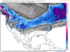
Seems to me the models are worse than ever before at predicting where and when precip happens. Not sure why we even bother looking.... 12 hour span of GFS models: 18z: 00z 06z4 points
-
Looking at your post history, you seem to be a bundle of joy. Not saying you're wrong on a lot of your posts, but couldn't hurt to be a bit more decent.3 points
-
I’m excited for sunny and 40’s this weekend. That’s a lock. whatever happens (snow wise) after that will be a bonus. 10 days til March.3 points
-
The desperation around here is palpable.3 points
-
It is snowing now in Cedar Rapids. I wasn't expecting any snow today. Radar suggests it could last for at least a few hours.3 points
-
We've had the 4th wettest February on record. Total of 3.01". More rain on the way from the south beginning late afternoon and continuing through the night. Temps in the 40's. More rain possible this Sunday. 40% chance. I'm enjoying while I can as the tap may shut off early.2 points
-
The lead storm showing up late this weekend into Monday needs to be watched for a marginal set up for snow on the northern edge. Models have a tough time figuring out how much cold air there is to work with in these type of events. For example, the last system that tracked over the region, days before the event, the models were predicting there would be more rain than snow and many of you saw snow instead. I think this will be another similar setup. I'm seeing more evidence among the EPS/GEFS members that there could be a swath of snow on the northern periphery. Depending on how strong it develops, some dynamics may be in play to support more snow in the forecast. Meantime, the 00z EPS continues with a more southerly track with the second system and taking on a more TX Pan Handle Hook up into the OHV. Once again, this has been the hot spot in recent weeks where storms enter the "slot" and then track towards the OHV. I know there has been some discussion on here regarding teleconnections not favoring a wound up storm, however, it's not always about the AO/NAO but moreso where exactly the blocking is setting up. That being said, the good Ol' "Banana HP" across S Canada is going to be a key component. There is no down playing it, a massive and expansive HP will grow across the northern tier of the U.S./Canada allowing the flow to slow down quite a bit. Just need to see the models figure out what to do with the pieces of energy and how much they can dig. At this range, both the GEFS/EPS are very similar in terms of placement of the HP & SLP. This pattern screams to me there will be a ton of moisture available to tap. Not only that, but both the LRC/BSR indicate this could be one of the more stronger signature storms of the season. Let's see where we go from here.
 2 points
 -
Wow, haven't been on here in a while. But not much to talk about. Would love one huge storm and then for spring to move in. These constant teases and short blasts of bitter cold air are getting annoying! But, I have been talking to Dean Wysocki and he said the AO doesn't really favor a big storm like this and a more progressive system. YAWN. But hey, stranger things have happened right. Latest CMC is the complete opposite with a dry cold arctic blast with a rainstorm ahead of it. Lovely!2 points
-
Yeah, crush job from the 00z GFS. I have spring fever, but I wouldn't pass up something like this. The problem is the Euro has nothing like this. It does not dig the energy in the Rockies like the GFS.2 points
-
Some pics/images from our big blizzard last year on 2/23. Crazy storm!

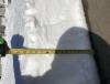
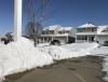
 2 points
 -
Heading down to -8F tonight with the massive high sailing overhead. I’m ready for upper 30s and possible low 40s this weekend. I have a bit of spring fever. Cue the upper Midwest spring snowstorms in 3...2....1.1 point
-
Well you better get ready then because word on the forum is that REAL WINTER arrives in.... that’s right, TWO WEEEEEEEEKS!!!1 point
-
Grand Island has been reporting moderate to heavy snow the past couple of hours. Clint must not be too impressed because its silence from him . The usual steady light pixie dust has commenced here with a very light dusting now.1 point
-
So far for the first 19 days of February, I've had .2" of snow and .01" of lt rain. Average temp has been 2.1 degrees above average as well. Zzzzzzzzzzzzzzzzzzzzzzzzzzzzzzzzzzzzzzzzzzzzzzzzzzzzz...........................................................................................................1 point
-
Here's a shocker, the NWS thinks the GFS is way off base. Sunday night into Monday the GEM/ECMWF/GFS both have a system affecting the area. The momentum fields vary widely between the models so confidence is low on potential impacts. We currently look to start out with rain and then transitioning to snow across the area. Amounts of for each are uncertain at this time as the GFS says its game on and the GEM says we barely get clipped, with the ECMWF between these two. Believe the GFS is greatly overdone and if not using a blended like forecast, would stay away from. Otherwise we will have to wait until we get closer to determine effects.1 point
-
There is something falling from the sky. It is white. https://nebraska.tv/weather/camera-network/holdrege1 point
-
Right, I just got a bit excited to see snow because we just haven't had any big snowstorms this winter, and we are running out of time to get something big.1 point
-
12z EPS and GFS ensembles for the next 180hrs1 point
-
At 24F under beautiful sunny skies and patches of snow around.1 point
-
1 point
-
Of course today NWS Hastings is lowering snow amounts because that is the theme of this horrible winter in this area. Was maybe going to get 1-3" now T-1" at most and that might be generous. Been a long time since a snow event has over performed around here.1 point
-
The 00z Euro is down to a weak to moderate clipper. The GFS and Euro both show the energy reaching South Dakota, but at that point they diverge. The Euro shows a significant lobe of energy up in Canada that dives down and keeps the Dakota energy moving e/se, so nothing can slow down and spin up into something big. The GFS does not show any kicker energy, so the Dakota energy stalls, which allows the backside jet streak to dig south in the Rockies and southern plains and spin up into a major storm.1 point
-
That is the largest weenie run of the year for me1 point
-
Fantasy Land-1 point
-
Measured 3.5" when it was just about ending here last night. Can't believe I beat SPS Top 1.5" was total cotton balls. Stuff was pretty fluffy despite temps just below freezing. By the time I stepped out for work, temp had risen to 36F and the snow was a very slushy 1.5" Ofc, it had rained a bit too but that's some serious compaction!1 point
-
Lol at the GFS once again...1 point
-
If it stays cold, my ski hill has a chance at setting a record for the longest ski season. I was talking with one of the people who work there today, they said last Sunday they had their third-highest day of ticket sales, ever.1 point
-
Pretty obvious where the winners have been this season...just across the "cheddar curtain" and points north...you guys have had a decent snow depth for some time now, right?1 point
-
13" snow pack atm.1 point
-
18*F yesterday morning. Barely beats the 18.3*F from a month ago, for a new coldest low of the winter. Pathetic. By far the warmest “coldest low” of any winter on record except for 1878/79. Maybe. Depends on whether you account for station relocations, UHI, etc.1 point


This leaderboard is set to Vancouver/GMT-07:00