
Leaderboard


Popular Content
Showing content with the highest reputation on 02/26/20 in all areas
-
Up to 2.5" now...the top layer has the look of puff balls...everything is covered with a nice covering of snow...it's back to Winter in this yo-yo season. Should be a nice scenery when daylight emerges and with cold temps hanging around for more than 48 hours, the snow should stick around for the longest period post-storm for any system this year (sadly).7 points
-
Looking like a split flow remains for the foreseeable future. If it isn’t going to snow, let’s rock and roll with an early spring.6 points
-
Was at 4.5" imby as of 7 pm. As expected (and all too common this winter) there was a ton of melting on concrete due to the 3 day torch beforehand. Shoveled my driveway which had 3" over 1/2" of slush. Salted streets/roads had much less than that even. Not complaining ofc, especially with so many of our Sub Peeps getting shafted by the models.
 5 points
 -
Wowza! URGENT - WINTER WEATHER MESSAGE National Weather Service Buffalo NY 1258 PM EST Wed Feb 26 2020 NYZ006>008-270200- /O.UPG.KBUF.LE.W.0004.200227T1200Z-200229T2300Z/ /O.NEW.KBUF.BZ.W.0001.200227T1200Z-200228T2100Z/ Oswego-Jefferson-Lewis- Including the cities of Oswego, Watertown, and Lowville 1258 PM EST Wed Feb 26 2020 ...BLIZZARD WARNING IN EFFECT FROM 7 AM THURSDAY TO 4 PM EST FRIDAY... * WHAT...Blizzard conditions expected. Total snow accumulations of 3 to 4 feet across the Tug Hill Plateau, and 1 to 2 feet for surrounding lower elevations. Winds gusting as high as 50 to 60 mph will result in severe blowing and drifting snow. * WHERE...The Eastern Lake Ontario Region. * WHEN...From 7 AM Thursday to 4 PM EST Friday. * IMPACTS...Travel could be very difficult to impossible. Areas of blowing snow will produce near zero visibility. The hazardous conditions will impact the morning and evening commutes Thursday and Friday. Strong winds could cause some tree damage and scattered power outages.5 points
-
Level 2 snow emergency has now been declared for my county. That means people should only travel if they absolutely need to. Don't think we'll get to level 3, which means that all roads are closed to non-emergency personnel.3 points
-
End of the 12z GFS (I know lol) has a massive cutter. 60s and rain here, maybe even some thunder. If this February isn't already the start of Spring, then there it is.3 points
-
My parents live in McPherson,ks lol
 3 points
 -
00z Euro...this storm just annihilates Ontario as it bombs out Thu/Fri...
 3 points
 -
Tonight's Euro has 53º here Saturday and 61º Sunday. Unfortunately, it also has no precip for the next ten days, so it could get a bit boring.3 points
-
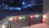
Those be year-round festive lamps!2 points
-
If you don't get snow, may as well have it warm. I'm about ready for Spring.2 points
-
Amazing what just a couple degrees does! And yeah, blowing everywhere here, driveway has anywhere from a quarter inch to well over 6. Best measurement I have here in a protected area non-drift is 5 inches, so that's what I'm going with so far. Edit: Which makes me happy after seeing the late morning dry slot (third of the storm and first un-forecast) which definitely dashed my hopes.2 points
-
Highs this weekend keep getting bumped up with every new forecast package the last couple of days. Now low 60s for both Saturday and Sunday. Hello spring!!2 points
-
Yes...I am getting moderate to heavy snow attm. Temps are thankfully in the upper 20s.2 points
-
Enough snow yesterday that they had to plow the streets and parking lots. We have new snow piles.2 points
-
Snowing moderately, temp at 29F. Will be snowing all day into late tanite (midnight) or so. Canceled my flight to Boston for later today due to inclement weather. I guess its worth it not missing this snowstorm (I think)2 points
-
WOOF! WOOF! Big Dog wakes up alright...for Canada Peeps2 points
-
This weenie band is lasting longer than radar would indicate. Looks like the flakes are finally starting to get a bit smaller, but I'd say I've picked up 1.5" or so in the past hour. 32.2*F.2 points
-
I've been lucky to have the band of snow continue to re-develop over Cook county. Temps have dropped a tad below freezing (29F) and the snow is a little fluffier. The dendrites are nice and big about moderate size which has been the common theme with this system thus far.2 points
-
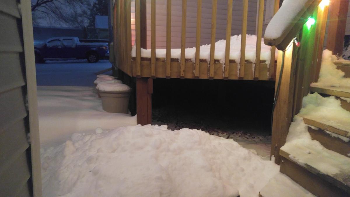
Just measured 2.1" on my deck...surprised to even have that much. Took a look at the local radar loop and it hasn't stopped snowing since about 4:30pm yesterday which in my book is about as good of a win from this system as one could expect.2 points
-
Thanks amigo...hope you score good w this storm. Cant believe that w this type of mild Winter, Detroit manages to get its 3rd snowstorm of 6"+. Wow! I think so far, the city is at 31.6" or so (give or take).2 points
-
As far as im concerned. Winter is over. I've completely given into it. We can no longer just say "we have plenty of winter left".1 point
-
Nice pics amigo..... Btw: I like your Christmas lights1 point
-
I forgot something! Wind has picked up so blowing snow is now a thing!1 point
-
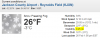
Remember the post I made where I said temps were too warm? Yeah, well.... Temps have dropped sharply. The slush on the roads that was previously not an issue flash froze, and snow is falling on top of that. Roads are a disaster here. 23°F.1 point
-
Coming down moderate to hvy at times, blowing snow as well. Not sure I can tell from my window, but looks like more than 3 inches have fallen and counting. I will measure lata on tanite......Im thinking 6" or better should be doable by the time it all ends by midnight. We will see. Complete Winter Wonderland out there! Winds are gusty as well. Temp at 27F.1 point
-
Scored a light dusting and a lot of rain.1 point
-
Thanks amigo....btw, how did you do w this storm. If I'm correct, I think you were on the fringes of of the main precip, no?!1 point
-
Was Rip City here for a bit around 2 pm
 1 point
 -
Should be another warm day today, but not as warm as tomorrow. Then by Sunday it's chilly again with more insignificant rainfall possible.1 point
-
Currently in a lull. Should pick up again by 2pm or so and start accumulating.1 point
-
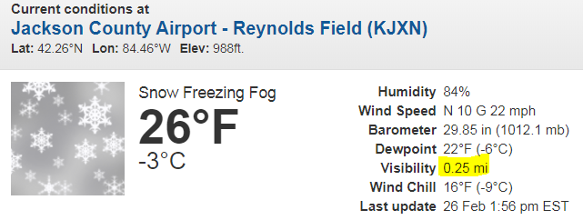
Wow, you did alright over there. Due to a 7 hr lull in anything meaningful (04z-11z) I gained very little while I slept. Measured just 1.3" when I stepped out for work. Pretty disappointed in that tbh. Per my airport unit, it's been a pretty good stretch since 8 am tho, so there should be more to measure when I get home. Here in Jackson, the cars have perhaps an inch? (since 8 am)1 point
-
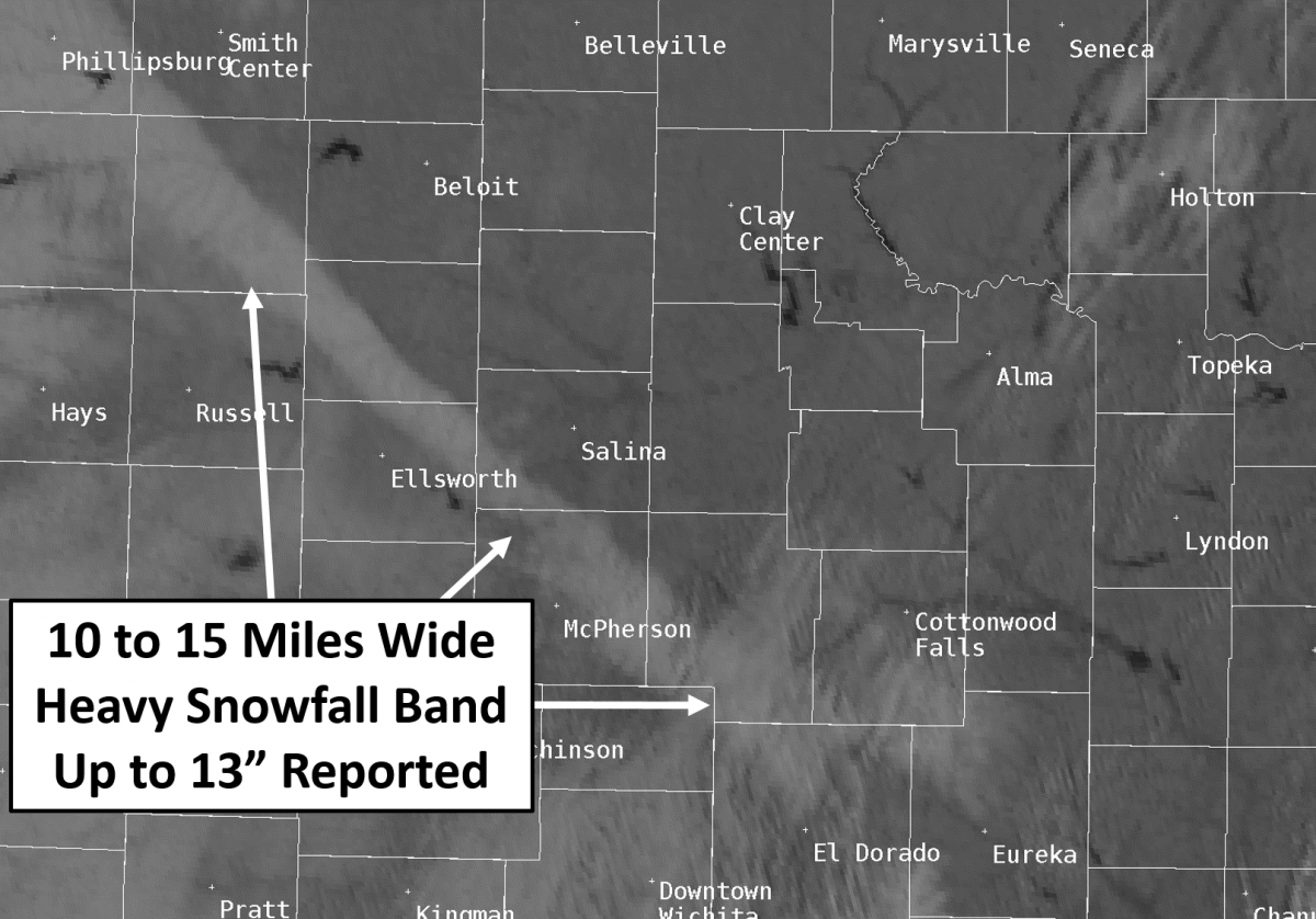
Here is another look at the snow band from NWS Twitter. Really cool to look at both of these. https://twitter.com/NWSHastings/status/1232697861000687617?s=201 point
-
I'm going to start paying more attention to the Ukie in day 4-5 range....still hoping for a nice thump this afternoon/evening but my expectations have been greatly lowered.1 point
-
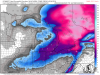
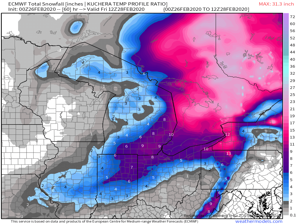
Looking at the water vapor loop, it's easy to see why this system didn't amount to much for much of the central US. It's pretty positively tilted and strung out. It will be more impressive once it reaches Canada and that northern wave dives in behind it.1 point
-
1 point
-
This has some potential to give accumulations greater than 6" here in SEMI.1 point
-
NAM likes SEMI big time. You'll be fine over there, just like all winter..1 point
-
Estimating 1" on my deck since it started, with about 1/2" on the concrete walks/street. Covering the pavement better than expected as my part of town seems to be quite the heat sink of warmth. As Tom said, it's been mild now for days. Kinda surprised much snow cover survived at all tbh1 point
-
Appreciate that SPS..epic model failures are a theme this winter, aren't they? Crazy!1 point
-
There is a old weather saying that "ice on a pond that can bare the weight of a duck in November the rest of the winter will be rain and mud" and yes there is way too much reliance on computer modeling and not enough old school meteorology of course now the meteorologists can point a finger at the models and now take as much blame1 point
-
Some good observations. Yea, I've heard it too, and from some "old school" meteorologists, that early snow and cold are not a good sign for a cold and snowy winter. Also, after this winter, I have come to the conclusion that computer models just suck! Unfortunately, I'm of the opinion that the field of meteorology is in a very bad state right now due to it's over reliance on computer modeling.1 point
-
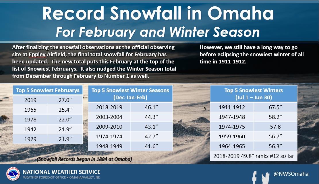
What a difference a year makes. 27” of snow last year in February. Not even 1” (.8”) this year.
 1 point
 -
Without any new snow, temps this week will not be as cool. With fresh snow, we would have been stuck in the 20s. Now, the Euro has one day of low 30s (wednesday), but then quickly back to mid to upper 30s and then several days of 40s and even 50s.1 point
-
Sorry. It's my microwave again. I've been on a major hot pocket binge. .... Hi. Very interesting and fascinating post.1 point
-
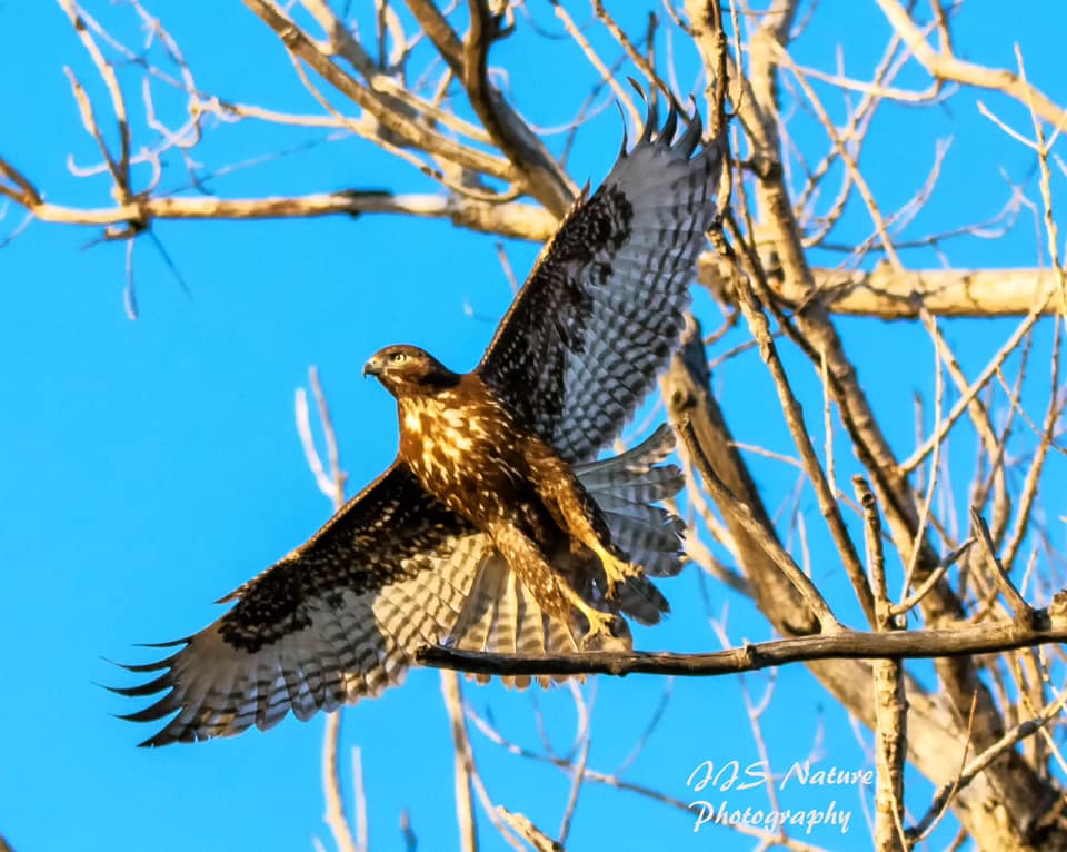
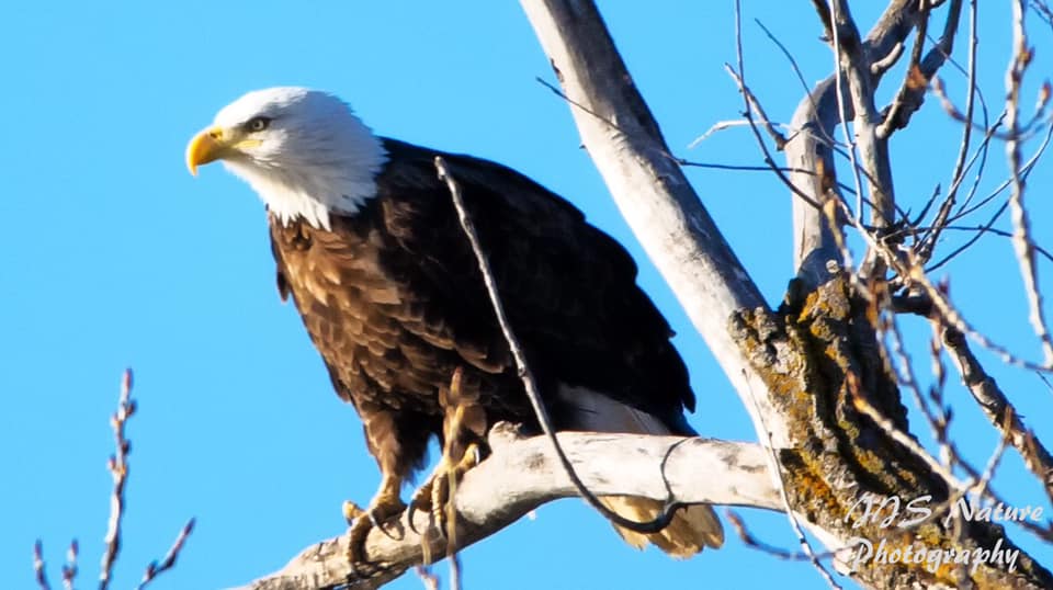
I went out to DeSoto on Saturday this past weekend and caught a couple of good shots. Saw at least 1/2 a dozen of Bald Eagles and several other large hawks. My favorite shot is probably the first one where this hawk was taking off from the tree. I've always loved these "action shots".

 1 point
 -
Beautiful day today and the neighborhood was buzzing. Everyone enjoying outdoor activities and kids playing everywhere. Some streets even turned into all out block parties. People are definitely ready for spring.1 point
-
I’ll add, “GFS extended was correct and Nebraska was buried in 30” of snow”1 point
-
Let's call this...THINGS YOU WILL NEVER HEAR ME SAY: WINTER EDITION! 1. "WOW...the heavy snow was supposed to hit Minnesota but it buried MBY instead!" 2. "The models locked me into the heavy snow track five days ago and totally delivered!" 3. "CRAZY...our official snow forecast called for 1-3" but we ended up with 14" instead!"1 point


This leaderboard is set to Vancouver/GMT-07:00