
Leaderboard


Popular Content
Showing content with the highest reputation on 06/09/20 in all areas
-
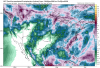
This is great! Cedar Rapids is parked under a heavy band. It appears I am over 1.50" now, will easily soar past 2".6 points
-
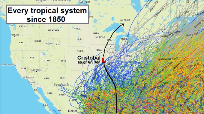
Very interesting tweet regarding Cristobal's track...living through history
 6 points
 -
Personally I'm hoping we get somebody from Fargo to join the board so they can spend the entire winter telling us about how awful continental air is and how we shouldn't be rooting for anything other than endless SW flow. That would be extremely interesting and highly relevant.5 points
-
Torrential rains in my backyard over the last half hour, went from a trace in my rain gauge to nearly one and a half inches in just over 30 minutes, and it’s still pouring rain with the cell stuck over Southwest Omaha. Winds are blasting out of the northwest with 40 to 45 mph gusts right now and have also seen some pea-sized hail mixing in.3 points
-
I just have more than a feeling the 4th is going to absolutely suck this year. #itsmorethanafeeling3 points
-
Flash Flood Watch has just been expanded to include the Omaha metro, for 2 to 5 inches of rain coupled with 60 mph wind gusts later today and tonight! Wow! Slight risk now encompasses both Omaha and Lincoln, with a 5% risk now for tornadoes. Needless to say it’s going to be a bumpy ride this evening and tonight.3 points
-
I agree that just west of CR appears to be where the heaviest will be, although CR should get a pretty solid total.3 points
-
This definitely feels like tracking a winter storm. The cut off over the Omaha metro area looks significant on the models with areas just north of the city not seeing much, while southern parts of the metro get nailed with 1 to 2 inches of rain and severe storms this evening and overnight. Interesting to see the enhanced risk issued for SE Nebraska and NE Kansas, could be a localized tornado outbreak in that area with all these ingredients coming together. Spent an hour this morning putting away lawn furniture and tying down stuff outside in preparation for the high winds coming in later today. High Wind Warning in effect for up to 60 mph wind gusts!3 points
-
Cool GOES-16 shot of the system as the sun comes up this morning. Clouds from Virginia to Kansas. https://weather.cod.edu/satrad/?parms=regional-midwest-02-24-1-100-1&checked=map&colorbar=undefined3 points
-
Prior to 1990, Eugene's last white Christmases were 1983, 1948, and 1924. In other words, it's pretty dang rare and not something that you would regularly anticipate.2 points
-
So 30 years since a White Christmas. You are due dude!!2 points
-
Preferences and opinions vs. opinions. Repeat twice a day unless otherwise directed by Dr. Phil.2 points
-
My weather station at home has 2.53” so far. Unfortunately not there to see this as I’m on vacation.2 points
-
3.88" in West Burlington. 2.65" in North Liberty.2 points
-
Yes I remember a number of tropical systems have produced good rains in my area over the years, but the rarity of this one is the low center itself is grazing far southeast and eastern Iowa.2 points
-
A report of 3" coming from Marengo in Iowa county! Heavier totals are just nw. and sw. of me.2 points
-
The personal stations near my house are all well over 2" now. The pivot point for the heavy rain is one county west of me. The biggest totals may be there.2 points
-
57 over in Grand Island this afternoon while still 85 in Lincoln. It looks more like a late Spring front, I haven't seen a sharp front like this so late in the season.2 points
-
It's like tracking the defo band of a Big Dog...this is the summer version...2 points
-
Tornado watch incoming2 points
-
Radar looks crazy at my place right now. Too bad I wont be home til 5302 points
-
It’s actually a bit stormy right now. Heavy rain and wind gusts around 30 mph under this shower. Definitely feels like late October.2 points
-
Hints of summer showing in the long range. A glimmer of hope.2 points
-
My total is approaching 1" and heavy rain just moved back in. 2" should not be a problem. The only thing missing is thunder.2 points
-
1.31" in Tiffin now. Likely will get to 2". I'm very happy with how this has turned out.2 points
-
Loving this before a looming dry spell!2 points
-
First enhanced risk of the year for my area I believe.2 points
-
Up in SLC they had a high of 100 and 3 days later a high of 55! That's pretty extreme for June.2 points
-
Great to slay the drought.2 points
-
Up to .65" here today since midnight. Whet!2 points
-
Pretty decent soaking this morning...with more rain to come over today and over the next 10 days things are going to be rather green and healthy headed into July. We only had 0.69” during May and June combined last year....nearly 3.5” now through May and the first 1/3 of June this year much better!2 points
-
The speed of that cold front out in the eastern Dakotas is going to decide everything. Seems as if its eastward progress has been hung up a bit. If that is the case, the remnants have a wider path to come north instead of veering off to the northeast. No reason to assume any of the short-term models are wrong though. Cristobal is a nowcast apparently.2 points
-
Flash Flood Watch expanded to cover the TC metro. 2-4" expected with localized amounts of 4+". Areas east of I-35 may see 5+". However, the NAMs and GFS are so far east now that the metro gets either nothing or very little precip. 11z HRRR and RAP are also a shut out. WOW. lol2 points
-
5 AM and I'm already up to 0.65" for the day, a daily record for June 9th.2 points
-
It’s been a bit breezy here too...definitely didn’t feel like June. So far it’s the 3rd wettest day I’ve recorded in the month of June in the last 15 years.1 point
-
Getting blasted by some non-severe but fairly strong thunderstorms currently in Omaha. Haven’t picked up much all that much rain so far this afternoon and evening... however plenty of moisture is coming up from the south and west. Lincoln is under a Flash Flood Warning currently, and this same system of storms is moving into Omaha now.1 point
-
the native american indian tribe has reduced the number of weekends i can go buy explosives to try and lose a finger or eye with it's a bad omen1 point
-
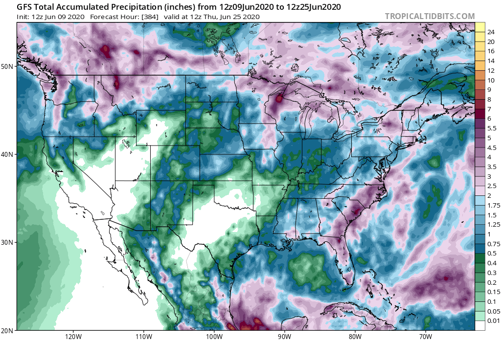
Future drought regions I've made mention of starting to show up. These 2 areas are what I was expecting to a "T". I'd look for this to expand throughout the month and then build out over and to the E/NE with an anchored ridge system/Bermuda high. The Western US ridge/drought area should remain pretty steadfast throughout the summer other than occasional migration into the monsoon season. After a few years of strong activity out there I look for that to be half or less of the last 3 years averages. Long term drought look as like the outcome here and a late summer with legs for Eastern areas of our sub as the late summer wears down. (Late July-Aug time frame for that area into the NE US. My $0.02 worth. For now. Is it right? Guess we'll see.
 1 point
 -
Good question. He didn’t specify in his post but I assume it’s every tropical storm that made landfall?1 point
-
Definitely more disposable income when you’re single. This family thing kicks the out of your bank account1 point
-
from what I recall the spring and early summer of 2017 had a decent amount of rainfall around western WA then it turned hot and dry in the second half of June. Ended up being a smoky hot summer still because there was virtually no rainfall after early June. We will just have to wait and see hopefully we can avoid that.1 point
-
Around 0.94" here so far. More moderate rain moving in.1 point
-
Good luck down there!1 point
-
About half an inch of rain overnight. 1.43” on the month.1 point
-
.32” now. It’s dumping!!1 point
-
Pdx well over 2” on the month now.1 point
-
And all we had to show for that labor was a jet ski and winter 2002-03. Thanks.1 point
-
Euro gave up on the east rain band. I would be happy with 2".1 point
-
Got clipped by the south edge of the cell. 15 minutes of heavy rain and gusty winds. Glad to be missed by the potential of 2 inch hail.1 point


This leaderboard is set to Vancouver/GMT-07:00