
Leaderboard


Popular Content
Showing content with the highest reputation on 09/06/20 in all areas
-
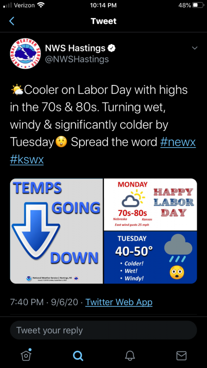
Talk about extremes: -There is a Winter Storm Watch for Tuesday in the Denver Metro Area -Meanwhile, 98F is the projected high for today -Rain will be changing to snow on Tuesday with a high of 36 along w significant snow accumulations4 points
-
I picked up 1.06" of rain this morning.4 points
-
Looks like we “only” made it to 93 today. First front has come through and turned winds out of the northeast to 15 mph. We’ve fallen to 88 degrees right before 5 pm. Going to be an exciting weather week around here. Need rain desperately.3 points
-
Saw someone on a different board point out Laramie... Just poking through the daily summaries in Laramie, the record lows look to be in the upper 20s or so this time of year. THREE BELOW ZERO is forecasted there Tuesday night.3 points
-
"Only" made it to 95 here today, after several days of it looking like we would be making a run into the 100's today. The rainfall deficit continues to deepen closer to 12" on the year, however this next week offers us a nice respite with some really solid chances of moderate to heavy rainfall. Either way, I will welcome the cooler and rainy weather, and I have some hope now that we will put a bit of a dent in that rainfall deficit by the end of the week.2 points
-
#KeepTheLikes2 points
-
Reasonable accumulation season here is October-April. Fargo has received early October blizzards the past 2 straight years. Fargo averages 50.1" annually, however that was heavily inflated after a snowy 2001-2010 period. The 1971-2000 average was 46.3".2 points
-
April '91 in NMI is my personal wildest swing. Saturday was spent riding my bike in shorts under sunny and 85F. By Tuesday evening was riding my snowmobile around my place on a solid 5" snowpack from a storm the night before. That was my first year up north and I'd never witnessed such extremes. I was totally stoked!2 points
-
Some of these crazy CF scenarios hit last autumn Iirc. Are we just witnessing the same (old) pattern prior to a new LRC developing? I think so tbh. Those are some wild wild wx flips on deck. Not sure how many caught news on this, but there were several anomalous wx events on the other side of the globe during this summer. I know China had some unusual snowfalls. Even Beijing saw wet flakes in July. That'd be like a Midwest city seeing them. Very rare stuff due to Solar Minimum imho2 points
-
12Z NAM has the snow line over Central Nebraska Tuesday night. Ground is way to warm, but it’d be something to see some flakes on September 8 or 9th.2 points
-
A tightening pressure gradient is resulting in rapidly increasing south wind gusts over the nearshore and open waters of Lake Michigan. Winds are increasing to 15 to 25 knots with gusts to 35 knots. Snowstorm fanatic's dream pattern aka 07-08 & 13-14. Need this to come back in Jan2 points
-
Iowa city airport reported 0.93” so that’s as good of a guess for here as I can give. I thought maybe an inch so that seems in line. I need to buy a new rain gauge2 points
-
Today's high in Denver is 98.2 points
-
With all due respect to Euro, I don't think I've seen a recent seasonal map from them that hasn't been ridiculously globally warm.2 points
-
Sitting in my fam rm with a nearby window ajar. Just heard a distant long thunder rumble. It's getting closer..1 point
-
Tbh, radar doesn't look too ominous. We will see. Sometimes these cells explode outta nowhere.1 point
-
I like how you can add files straight from the mobile version now. Seeing who likes posts would be cool but if it's not possible I understand.
 1 point
 -
So far, the Severe Watch hasn't produced any severe warnings to our north even tho NWS statement mentions that any of the current storms could get stronger and reach severe levels. I'm more/mostly concerned with getting another drink of water around here. Otherwise, it's a great night and I mowed the part of my lawn that were tall just before dark anticipating the storms and because I have a road trip tomorrow.1 point
-
Going to try out the new upgrades. I apologize if I mess up.
 1 point
 -
Temps actually plateaued after the front passed. It quit rising, but it was also very slow to fall. I now have a stratus deck which I will likely have until Tuesday, and that will moderate temps until then. Persistent NW wind which will usher in the CAA. 72.5*F. Omaha currently bakin' at 95*F. Once again, glad I got the front in the morning.1 point
-
Well at least now we’ve discovered the only type of weather you are content with. Just have all time record warmth year round and you will hear no complaints from MML.1 point
-
Can't wait to see if your KFAR snow total beats your KTOL from last winter. Shouldn't be a heavy lift but not familiar with ND clink tbh. Thinking your season will be way longer than Ohio tho. Beck, even my total almost doubled Toledo's1 point
-
Barometer is down to 1006mb here, winds are up to 35mph out of the NW. Summer is over. I'm glad the front passed in the morning, I didn't want the 90 degree temps that would have happened with an evening fropa. Sioux City forecasted into the mid-90s today.1 point
-
Attm, it is a pleasant 71F under mostly cloudy skies. Lotta wet weather coming during the next several days. Should impress the "Drought Monitor."1 point
-
Yeah jaster I'm also happy to see you back! I thought you ghosted us for good. You were like 90% of my liked posts1 point
-
Euro enjoys a couple weaknesses and seasonal seems to one of 'em1 point
-
Thanks everyone for the warm welcome back. Here's to hoping this is a winter where the actual results mirror our sub's expectations. I know those N and W of SMI have scored some big storms the last 2 winters. Forgive me if I'm cheering on a shift eastward hahaha1 point
-
Yup, they started in October and this pattern is the same “Old” LRC Pattern. I’lm curious to see what this years pattern looks like. Only a few more weeks to go!1 point
-
@Jaster....nice to see you back!1 point
-
Managed to get the very tail end of this system and at least got a nice little downpour of 0.46” and 2 close lightning strikes. Otherwise not much lightning. Was hoping for two storms following each other but the last one crapped out just before it got here.1 point
-
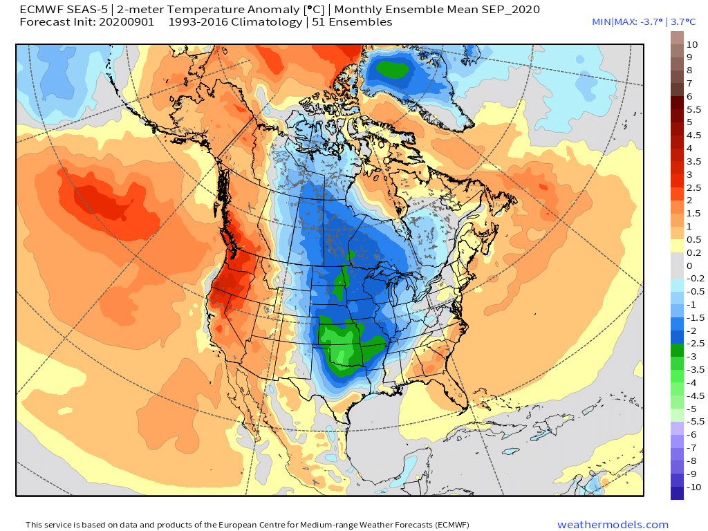
So, the big clue coming out of the Euro seasonal is the blocking that is trending up across Canada and the Pole as we get closer in time. The La Nina signal is growing colder and stronger across the central & eastern equatorial PAC. October has come in much colder for the central/southern Plains and wetter. November temp map looks skeptical and prob advertising a warm bias. Look at the blow torch over the Pole/Archipelago and how does that translate to a warm CONUS??? Needless to say, these are positive signs for the new LRC.1 point
-
The latest Euro Seasonal came out today and the maps speak for itself as the model has trended a lot colder for the central CONUS. I posted maps before on the placement of the ridge in the NE PAC, or lack thereof, from 2 runs ago and now its showing up as a monster NE PAC ridge. It has also trended wetter. Let's not forget about the Bearing Sea trough as well. Interesting run.
 1 point
 -
Storms finally sunk down to I-80. I’ve been getting hit with heavy rain for the past 20 minutes.1 point
-
Congrats to the Iowa peeps who need rain!1 point
-
Unfortunately, the storms did not track farther sw. They are training just barely northeast of Cedar Rapids. The Manchester area, west of Dubuque, has received over 5 inches of rain. The storms are trying to sink/build south a bit, but I'm just now getting into a bit of rain. The tail end of the line should get us.1 point
-
They're getting the reward for what they've built/allowed. Waaahhh!!!1 point
-
Yeah because normally blue or darker colors are for colder, which is what ice is. Haha Anyway, welcome back Jaster!1 point
-
There he is! Whats going on bud! Are ya ready for this upcoming Winter?!1 point
-
Hey welcome back!!!1 point
-
Omaha finished with it's 7th warmest summer ever and 4th driest summer. It's been a struggle to keep up with the watering. We're at about 50% normal precip so far this year.1 point
-
Naxos, Greece AHHHhhhhhhhh........NO place like Greece!!1 point


This leaderboard is set to Vancouver/GMT-07:00