
Leaderboard


Popular Content
Showing content with the highest reputation on 09/15/20 in all areas
-
The haze here is so thick that our high temp forecast has dropped from 81 to 72. It basically looks cloudy out there, and the sun in the sky is so faint that I can directly stare at it. 59.4*F and barely rising.3 points
-
The latest IRI Multi-Model ensemble came out to day and has trended kindly for the majority of our Sub if your looking for Winter to return this season. Let's dive in... OND... Here's a comparison from last months run for the NDJ period... Last month vs current run... VS Current Run...cold across the Plains/Upper MW/MW/GL's/SE...Warmer in the SW U.S./S Plains and over near Greenland... Finally, the last comparison is for DJF period from last run to current run...same scenarios are happening as the model got colder and warmer in the same regions mentioned above...I see you Blocking! VS Current Run...2 points
-
Today is noticeably more sunnier than yesterday. I can see blue color up in the sky which was non existent yesterday.2 points
-
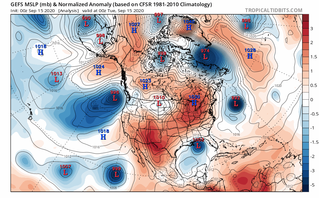
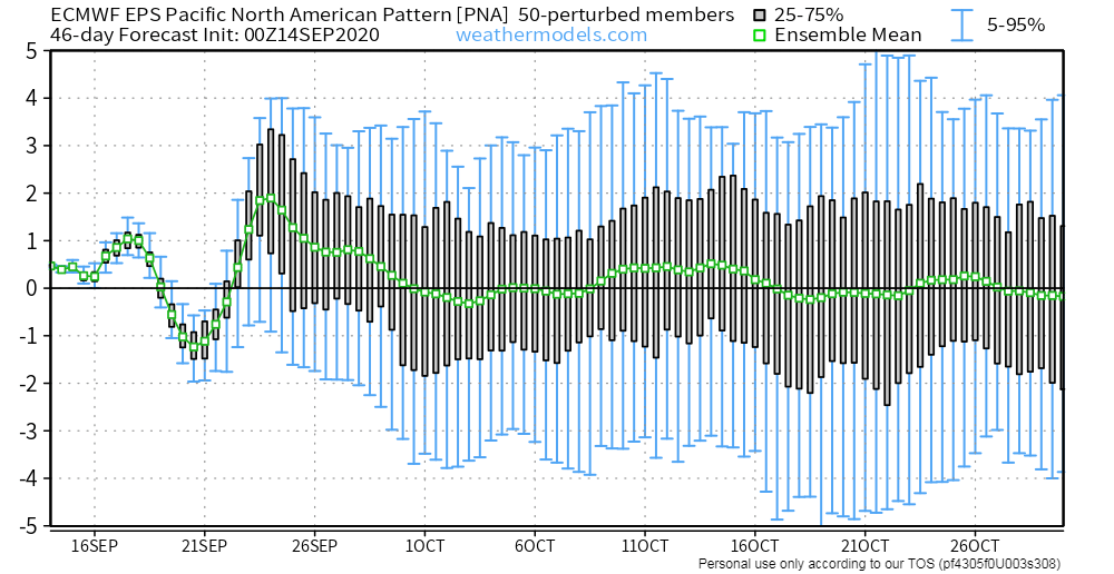
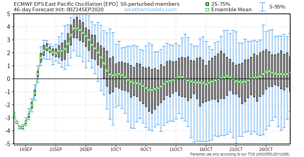
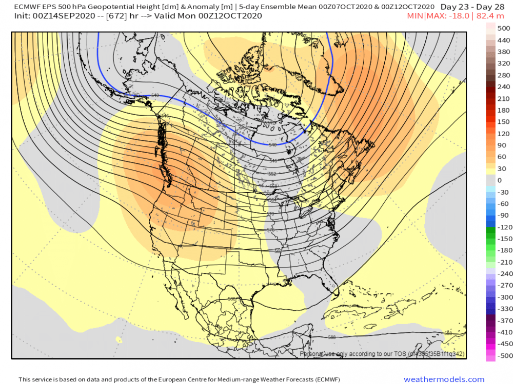
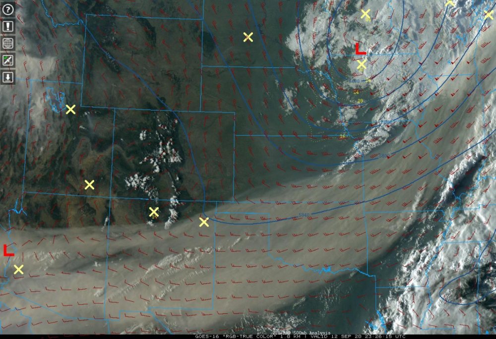
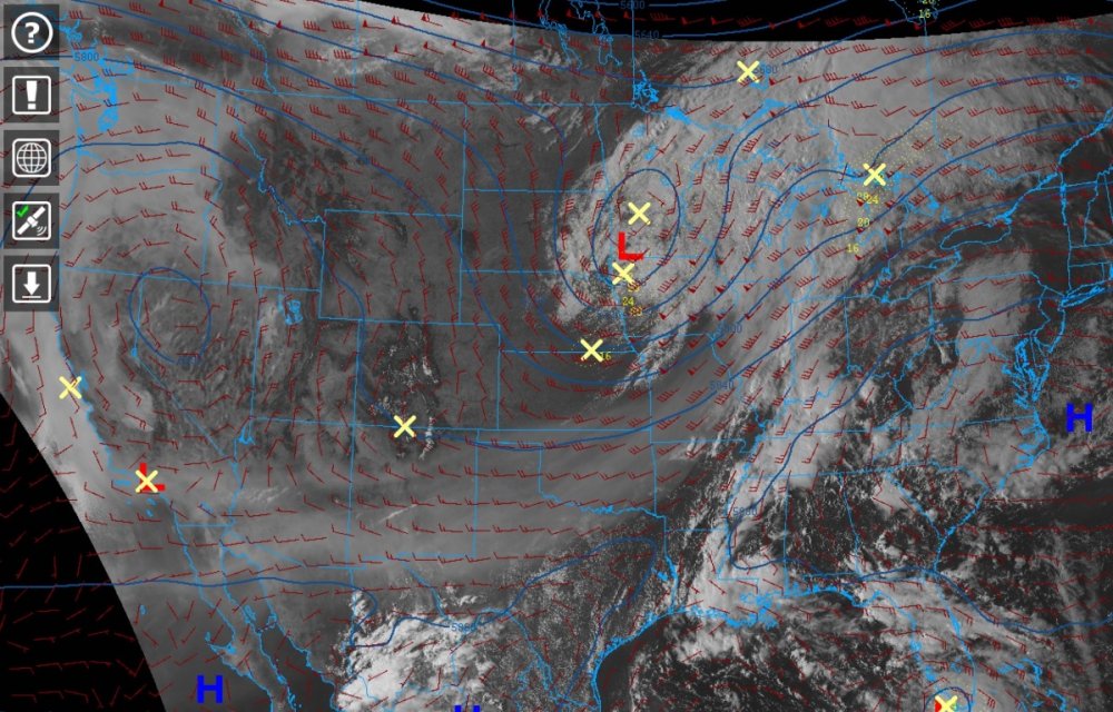
While sippin' on my coffee this morning, enjoying the cool and fresh air flowing into my room from outside, it reminded me how much I was yearning for these Autumn mornings during the HOT Summer season. With that being said, I took a gander at the pattern all the way across the N PAC and wanted to see what it may show for the October opening. I'm not sure if you all remember, but over the past few years I've shown how storms that form near the Sea of Okhotsk end up advertising a similar pattern across the PAC NW/Western Canada. This September, I'm seeing a similar but different pattern that is producing what was a dominant -PNA pattern last year and the year prior. Storm systems that are coming off the Asian continent are tracking farther south, thus, impacting W NAMER in a different way this year. Back on Sept 8th-9th, there was a stalled out storm near this region the meandered for a period of a few days near the Sea of Okhotsk which then tracked into the Bearing Sea. Fast forward about 6 days or so, the storm that has formed just offshore of the PAC NW which will bring relief to those being impacted by the Wild Fires, I believe is directly related to this pattern. In years past, these storms would have tracked into British Columbia, this year they are tracking farther south it appears due to a +PNA pattern. Sept 8th....the blocking Eurasian HP to the N of the system near Japan is a much different pattern, almost opposite of what it looked like last year which then correlated into a dominant W NAMER trough (+EPO/-PNA). Fast forward 6-8 days, we see the storm off the PAC NW slowly make its way to our coast....see animation below... Another clue this year's pattern is different than year's past is the behavior of storms near the Aleutians/Bearing Sea. The BSR is going to be a big clue in this years pattern. Last year, how many times did we see a massive 500mb ridge build just S/SE of the Aleutians??? This, in turn, correlated to a huge SER signal in the extended and we saw a never ending -PNA pattern. While we do see a spike in the EPO and a dip in the PNA next week, the overall pattern off the Euro Weeklies is predominantly the opposite of what we saw in previous seasons. The storm that is poised to track through the Sea of Okhotsk over the next couple days (see below) will enter W NAMER in 6 days and 6 Days later...massive storm across W Canada causing the +EPO...but the ridge builds back near the Sea of Okhotsk and that will build the ridge across western Canada. Now, that massive storm in the GOA that tracks between Sept 20th-23rd will be interesting as it should appear sometime during Week 2 in October and produce an eastern CONUS trough, unlike last year when we saw massive ridges near the Aleutians which then correlated to a East Coast ridge. What did the Euro Weeklies flash yesterday....fast forward 17-21 days...see map below...eastern CONUS trough! When I see medium range modeling agree with a LR model run, I tend to believe it based on the BSR theory. I know this is a lot to digest and understand but the way this September has behaved thus far is MUCH different than in recent years. Does that mean we will see Winter finally make its appearance when it counts this year and NOT the warm December's we have seen? IMO, yes...we are seeing signs that nature has #flippedthescript....add to the mix the blocking the models are missing in the LR and we may be seeing an interesting cold season ahead.
 2 points
 -
We hit a high of 77F yesterday and it really didn't feel that warm in the sun, or the lack thereof, due to the milky/hazy skies. It's wild how smokey it is out here and it looks like it will continue for the next couple days. Woke up this morning to the smell of burning wood throughout the house. I think my neighbor had a fire last night and I sure love that smell! Nice, cool and calm morning here today...61F/54F...I see some upper 40's are in the grid later this week/weekend. That's gonna feel a bit chilly for my thin blood. Slowly but surely I'm getting used to this pleasant weather. I accomplished a lot of yard work yesterday and while I was doing so, for the first time this season, the D**n mosquito's were out! Wouldn't ya know it, that at the tail end of the season, I had to deal with a few of them.1 point
-
I wish I had of made a forecast. These temps ended up verifying exactly as I thought they would of.1 point
-
I miss cool-cold Novembers and cold Decembers. I remember many of those in the late 1990s and early 2ks. After 2008, autumn has been remarkably different here. Here's to a shift in 2020.1 point
-
Funny how that works right.....and a month from now, 60F will seem very mild to us as well. Idk bud, but, October is sometimes a month that can have us all crank up the AC, as heatwaves have occurred in the past. So, we will see on that. Hopefully, like you said, we are mostly done w/ the AC.1 point
-
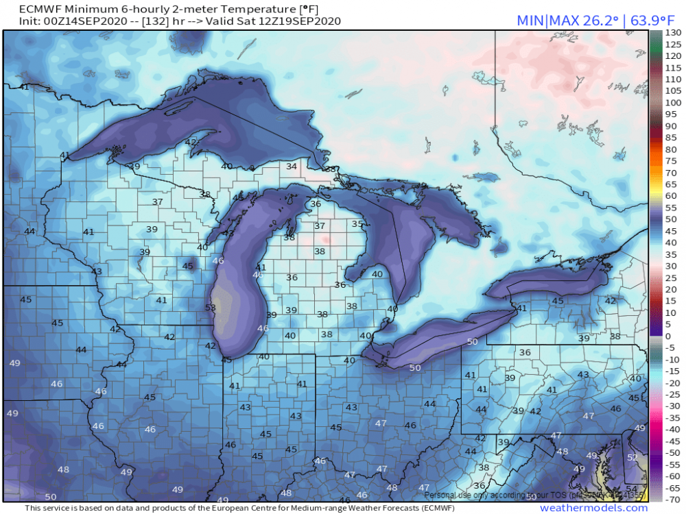
The departure from average so far this September at Grand Rapids is at -2.6. Some other Michigan sites with cooler that average means so far are Flint -2.1. Alpena -3.1 The Sault -4.0 and at Marquette they are at a whopping -6.3 so far this month.1 point
-
51° here at this time with a kind of milky sky that is either smoke or high fog. My guess it that it is smoke1 point
-
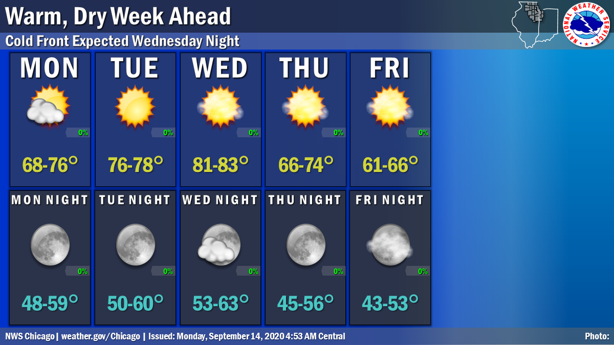
What a gorgeous day yesterday as we topped out at 77F with sunshine all day long. Things looked like they dried out a bit and that will allow me to finally do some yard work. A stunning week of weather and filled with bountiful sunshine. These are the Sept days I was looking forward to. A rather strong CF sweeps through Thu and Fri could be a tad nippy with highs in the low 60's. First 40's for overnight lows late week?? Excellent bon fire wx. 00z Euro a wee bit chilly for the GL's Sat morning...

 1 point
 -
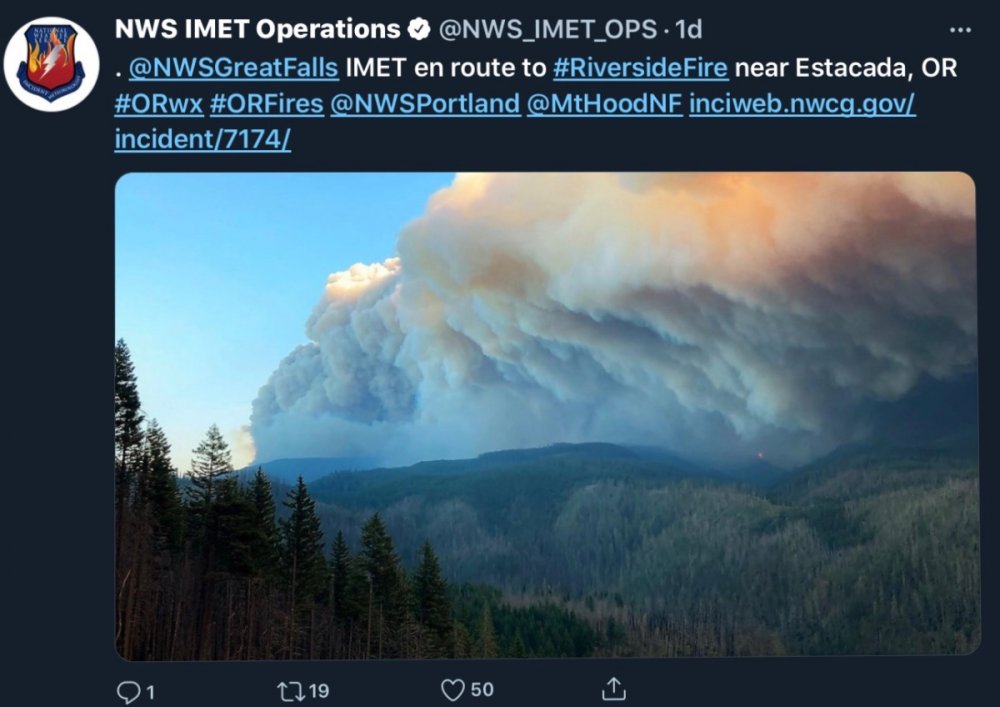
Here are some more smoke photos. Looks like it’s just to my southeast attm.
 1 point
 -
Me tou of.-1 points


This leaderboard is set to Vancouver/GMT-07:00