
Leaderboard


Popular Content
Showing content with the highest reputation on 09/19/20 in all areas
-
Went out for some photography today, and the colors were near peak The leaves changed FAST. Last week they were still mostly green.3 points
-
Here is hurricane "Teddy" in the open Atlantic heading close to Bermuda and then "Atlantic Canada." Currently a Cat3.....3 points
-
Took a drive around town this morning after a busy week of school, coaching, and watching games. Leaves are changing rapidly and quite a few are coming down with a strong south wind. The colors are the best I’ve seen in years.2 points
-
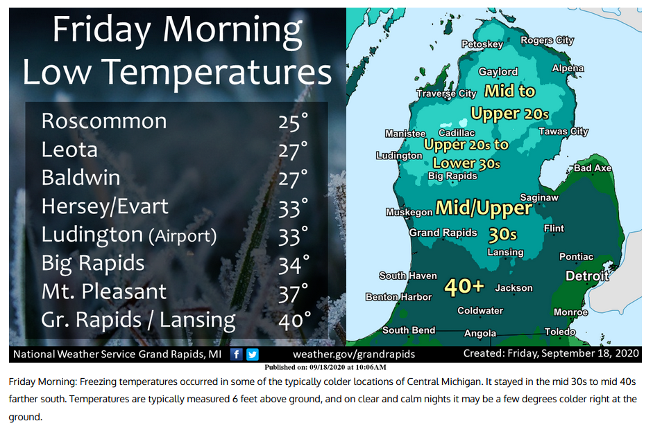
Frost was showing its presence this morning as cartops, roofs and grassy surfaces were covered in light frost. Here is my record low temp: The freezing mark this early in the season must also be another record. Have to check on that. NOAA: : ***MACOMB COUNTY*** RICM4: Richmond 4NNW :0900/ 68 / 32 Detroit remained in the upper 30s. Still, that is impressive for this early in the season. There were a few upper 20s in the far northern suburbs, (especially north of i-69).2 points
-
Thanks buddy! Even with windows closed all night, I had to activate the de-chilling devices, aka kitchen gas range burners and a space heater in the Fam Rm. Bedroom was tuck-under-the-covers cold. Best sleeping imho. Now I'm ready to enjoy round 1 of Indian Summer. I'm sure there will be several cold snaps followed by mild conditions this autumn by the looks of things.2 points
-
We did it! Nice to see Ma Nature still remembers how to send an early cold shot down into the Lakes. This is what '76 must've been like. I was just a sixth grader and can only remember deer hunting in absolutely bone chilling cold, but that was mid-November by that point.
 2 points
 -
The low at both the airport and here at my house of 36 ties the low for any September 19th at Grand Rapids. Here at my house there is frost on the roofs of houses and cars. With some areas of frost on the grass. So while not a killing frost there none the less was some frost. At this time it is sunny and 38 here with some of that frost still visible.2 points
-
It still hurts what seemed like what "could have been" an amazing winter for many of us while the LRC was setting up last year during Oct/Nov. I'll take that learning experience and move forward. Lot's of lessons learned and I'm REALLY paying attn to those signals that didn't work out last year, for this year's cold season. IMHO, the N PAC is catching my eye and the Greenland Block will be one of the wildcards this year. In recent years, the G.B. seems to show up in the Autumn and then re-appear in the Spring when the jet is weaker or weakening, but then disappears when the jet intensifies during Winter (DJF). I'm really curious to see if this year it breaks that trend.2 points
-
No reason at all for there to be a thread about it .2 points
-
Not any records that I'm aware of, but the northern 2/3rds of the Mitt chilled this early Friday morning. Saturday morning will be our turn down south. 38F with a 35F DP since midnight here. IF we could slide to 32F by morning, it would be more than 2 weeks earlier than average in this region. Needless to say, trees will start to respond in about 5-7 days. There are already a scattering of maples. September is normally our month of gold. The corn and beans are yellow, and there's a healthy crop of Goldenrod this year. Many trees and grasses get a pale green almost yellowish hue. October is the month of blazing reds and oranges. Ahhh....autumn is a wonderful season here in the Mitt.
 2 points
 -
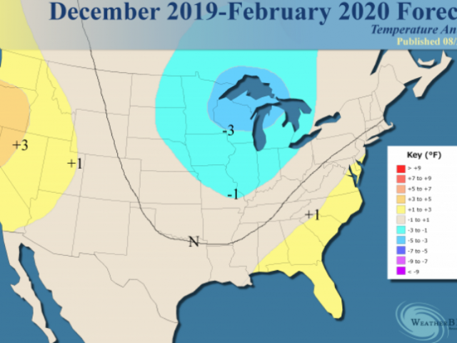
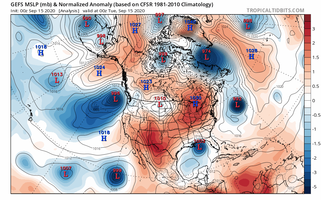
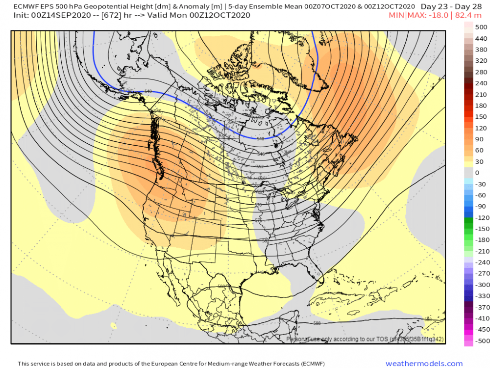
In OKwx's defense, at this time last year the winter WAS actually looking stout. But, we had to re-learn the age old lesson that SON looking awesome is NOT a guarantee that DJFM will rock. The weak-ish Modoki Nino was supposed to deliver the cold S and E but never did. It was another flavor of 18-19 when the winners were the W and N members of the sub. 19-20 was mostly the N members that did well as even your area (OMA) rode the line on many storms. A couple maps from last year at this point:
 2 points
 -
Tom, jaster and FAR_Weather, I love you guys. I appreciate that.1 point
-
Glad to hear her symptoms are mild so far! We’re having beautiful but boring weather here as well. The grass is mostly nice and green, but there still are some small cracks in parts of the lawn, etc. I’m still in the abnormally dry area on the drought map. Just a few miles north and southeast had better rains during the summer, so they’re in better shape. Could use another 2” of rain now. Today I was in nw. C.R. with a group of guys helping with storm cleanup. We were cutting down some badly damaged trees in someone’s backyard and cutting them all up. Some were large trees so we didn’t get it finished. There’s no decent access to the yard so I think they plan to just let the piles of wood rot. People from my area are going up about every week. Anyway, I got a good workout and I’m tired and kinda sore.1 point
-
An almost perfect day here weather-wise (outside of some gusty winds), a great day to spend some time outside... the smoke from the western wildfires certainly has obscured the blue skies and the visibility has even dropped just a bit. Was out working in the yard this afternoon and felt very little warmth from the afternoon sun. My wife unfortunately tested positive for COVID-19 a couple days ago, so going to be outside a lot more with my two boys to keep our distance as much as we can... it’s not a great situation but she’s been feeling okay, no major issues with the virus so far outside of a few mild symptoms.1 point
-
Not a fall or winter guess but just looking as some average last and first events at Grand Rapids. As we are now past the half way mark of September 2020 I thought it would be a good time to take a look as some upcoming first and last events at Grand Rapids. The average last 90° day at Grand Rapids is August 23rd the earliest last one was on June 10, 2000 the latest was on September 29, 1953. 1951 and 2014 did NOT have a day officially reach 90 at Grand Rapids. Last year the last day was July 20th and this year GR had 16 days of 90 or better with the last one on August 26th The average last 85° day is September 14th the earliest was on August 12, 1989 and the latest was on October 21, 1953. Last year the last one was on September 21st The average last 80° day at Grand Rapids is September 30th the earliest was on August 28, 1918 the latest was on November 1, 1950 Last year it was on September 30th The average last 75° day at GR is October 13th the earliest was September 15, 1981 the Latest was on November 6, 1975 Last year it was on October 1st The average last 70 day is October 24th the earliest was October 1st 1925 and the latest was November 23, 1931 last year to was on October 10th The 1st 32° low that will signal the end of the growing season. Before I get to that I will remind everyone that the last 32° low last spring was on May 13th and while there was a green up Grand Rapids also had lows of 26 on May 9th and lows of 29 on the 8th and 12th So the official start of the 2020 growing season was on May 14th At Grand Rapids the average first low of 32 is on October 13th The earliest was September3, 1946. The Latest was November 14, 1918. Last year it was on October 18th For a killing frost of 28 the average is October 28th The earliest was on September 23, 1974 and the latest was on November 29, 1948 Last year it was on November 5th For a hard freeze of 25 the average is November 8th the earliest was on October 3, 1974. The latest was on December 23, 2001 (talk about late) Last year it was on November 6th And for snow fall. The average that the first 1” snow fall occurs on is November 19th the earliest 1” snow fall was on October 12, 2006 the latest was on December 23, 2011. Last year it was on November 11th For a 3” snow fall the average first one is on December 5th the earliest one was on October 19, 1989 the latest was on March 16, 1949 Last year it was on November 11th when 5.5” of snow fell. This past week we had a lot of high-level smoke and that made the sky look a pale milky white on several days. It more than likely also held the daytime temperature down.1 point
-
Sunny skies and very cool conditions continue to prevail as temps still stuck in the 50s and most likely staying there. Another "Frost Advisory" for tanite as temps bottom out into the 30s once again. Although, if might not be as cold as 32F, temps will certainly drop to at least the mid to upper 30s.1 point
-
Never forget Jan 2019 with a high of 2 and just a crusty patchy dusting on the ground. Awesome winter overall, but that cold snap came right after a thaw lol.1 point
-
Tbh, I noted that both 2000-01 and 2005-06 were both classic examples of how a Nina winter can play out around the S. Lakes. Namely, you get an early onset of snowy conditions, or at least a December that would make a good January proud. Then "poof" winter pretty much dies right after the holidays. Not really what I'm dreaming about tbh, but the historicness of 2000 could never be turned down. 52" in Battle Creek that December! Grand Rapids did even better iirc. Now, 04-05 was a YUGE winter for SEMI with multiple storms and even a legit blizzard. The last legit one for Detroit proper since GHD-1 was a fail (7 or 8"), and the 2015 16.7" Big Dog (GHD-2) didn't have much in the way of wind.1 point
-
I kinda feel like if October is cold and snowy, there's going to be a bad DJF. I remember some of the best winters being out on the lake in early November on a jet ski on a nice day, and then a week or two later it's under 28f long enough to cover the ski hill in snow. Kind of like someone just flipped a switch and went, "hey buddy it's time to get off the water and get on the snow." Last year we had that early snow on Halloween (IIRC) got a nice cold snap, and then everything until Christmas was foobar. I remember because Alpine Valley blew snow first cold chance they got (their earliest opening over, I was out of town because they never open that early), and some of the other places waited. The places that waited barely made it open for Christmas season. A very nice cold snap in the second or third week of November is perfect for making snow and giving me a long season.1 point
-
Congrats amigo!1 point
-
NORTHWEST FLOW! My favorite! Yeah I'll take a January 2019 with a crusty inch on the ground and highs consistently in the negatives, please.1 point
-
Looks like many records are being broken to our neighbor to the east!. From what I see, KAZO is at 37F so far establishing a record low. Edit: Add Battle Creek, MI to the mix...new record low of 36F thus far... It's a chilly and crisp 42F here from one of the local reporting stations. Calm winds and clear skies will do the trick. I'm surprised its as chilly as parts of McHenry county where temps there are in the low 40's as well. I'm looking forward to having a bon fire at my sisters place later today. Got my space heater out for the 1st time this season warming up my room. Still not flipping on my furnace...well, at least not yet.
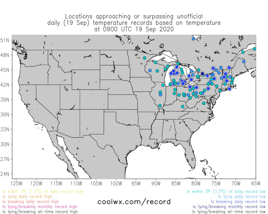 1 point
 -
Oh, I loved when it forecasted 110 here but it only hit 80. Like, 5 different times GFS has a dry bias over the heartland and it translates to some absolutely ridiculous temps.1 point
-
GFS has been a heat weenie model all Summer. GFS is about as laughable as GEM now. Iirc, even GEM got one storm right last winter.1 point
-
Thought I mention this, but yesterday I saw something really odd. Well, I was driving up to Romeo (not too far from my Pl) to my uncles house to help him set up his new TV set that he bought. Anyways, to get to the point of this, I happened to see a "Surrey" with 3 people riding it and mind you, there were 2 of them on the street riding along w cars. Now, I see these often in NYC, on 5th Ave and Central Park West, but never thought I see them here in Romeo. Interesting indeed! Btw: I wonder if the ride was free!1 point
-
The updated long range guess from the CPC is out and they are thinking that this fall will be warm and for the winter the idea is for a equal chances on the temperature (think near average) but their thinking is for a wetter than average winter season and into the spring. We will have to see how that plays out. With sunny skies and no noticeable smoke the temperature here is 66.1 point
-
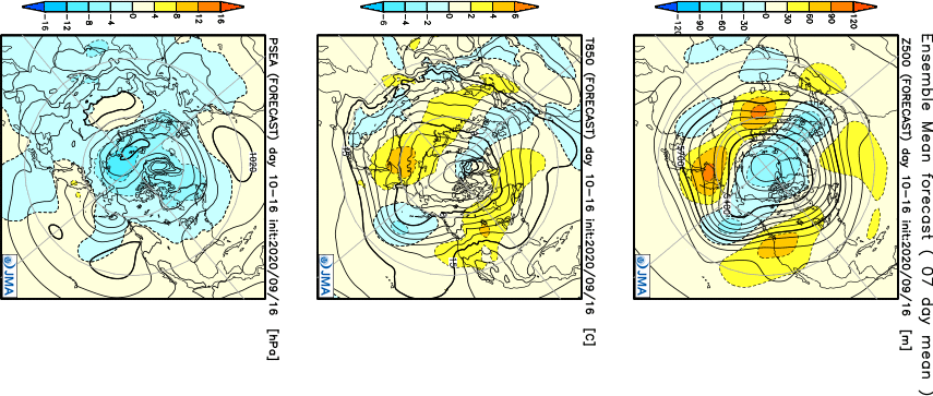
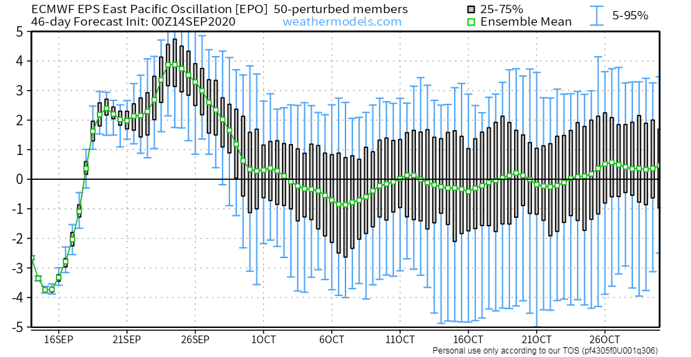
West-Based Greenland Blocks are the best for our the majority of our Sub while East-Based blocks tend to favor the EC bombs to develop. Guess what I'm seeing, at both 10mb/30mb, there is a significant warming event ongoing over N/NE Canada/Greenland which suggests to me the models will be increasing the -NAO signature in the coming days. In fact, you can already see the blocking at 500mb developing in the modeling as we close out Sept and open Oct. Gosh, this morning I've analyzed a lot of interesting data and the trends are favoring the BSR/N PAC pattern which has been so dominant over the past 2 weeks during the month of September. The latest JMA weeklies are showing the drought and persistent West Coast/SW Ridge to continue through the end of this month and into the first 2 weeks of October. Hints of the new LRC are beginning to show up in the LR which does NOT include a SE Ridge. Interesting, ay??? You would think there would be one in a La Nina season but nature may have a different tune. Well, for the most part, I do NOT see a strong signal for a -PNA pattern and the primary reason for this is what has transpired across the Aleutians the past 2 weeks and what is going to happen over the next 2 weeks to finish off the month of Sept. Week 2 Temps/Precip...I'm seeing a strong CF to sweep through towards the tail end of the month across the central/eastern Sub, but before that we will see a "puff" of very warm and delightful late season warmth next week. This model is showing a wet signal across the MW/OHV. Week 3-4...Slightly Warm overall and Dry...I believe this will turn more wet during next weeks run given the 500mb pattern it is suggesting and what both the East Asian rule and BSR are showing. Finally, I will end with this, here are the SST anomalies over the past 4 weeks and the shifting of the warm/cold pools across the N PAC/NE PAC are catching my attention. Aug 18th... Aug 25th... Sept 1st... Sept 8th... Sept 15th...
 1 point
 -
It was a splendid day yesterday. Perfect autumn day in my book. Temps topped out at 84F but the breeze made it feel quite nice. The CF swept through yesterday evening and I woke up this morning to the sound of the gusty winds blowing the trees in my back yard. Looking forward to a stretch of cooler days in the low/mid 60's and nippy nights in the 40's! Dry weather in the foreseeable future with bountiful sunshine.1 point
-
While sippin' on my coffee this morning, enjoying the cool and fresh air flowing into my room from outside, it reminded me how much I was yearning for these Autumn mornings during the HOT Summer season. With that being said, I took a gander at the pattern all the way across the N PAC and wanted to see what it may show for the October opening. I'm not sure if you all remember, but over the past few years I've shown how storms that form near the Sea of Okhotsk end up advertising a similar pattern across the PAC NW/Western Canada. This September, I'm seeing a similar but different pattern that is producing what was a dominant -PNA pattern last year and the year prior. Storm systems that are coming off the Asian continent are tracking farther south, thus, impacting W NAMER in a different way this year. Back on Sept 8th-9th, there was a stalled out storm near this region the meandered for a period of a few days near the Sea of Okhotsk which then tracked into the Bearing Sea. Fast forward about 6 days or so, the storm that has formed just offshore of the PAC NW which will bring relief to those being impacted by the Wild Fires, I believe is directly related to this pattern. In years past, these storms would have tracked into British Columbia, this year they are tracking farther south it appears due to a +PNA pattern. Sept 8th....the blocking Eurasian HP to the N of the system near Japan is a much different pattern, almost opposite of what it looked like last year which then correlated into a dominant W NAMER trough (+EPO/-PNA). Fast forward 6-8 days, we see the storm off the PAC NW slowly make its way to our coast....see animation below... Another clue this year's pattern is different than year's past is the behavior of storms near the Aleutians/Bearing Sea. The BSR is going to be a big clue in this years pattern. Last year, how many times did we see a massive 500mb ridge build just S/SE of the Aleutians??? This, in turn, correlated to a huge SER signal in the extended and we saw a never ending -PNA pattern. While we do see a spike in the EPO and a dip in the PNA next week, the overall pattern off the Euro Weeklies is predominantly the opposite of what we saw in previous seasons. The storm that is poised to track through the Sea of Okhotsk over the next couple days (see below) will enter W NAMER in 6 days and 6 Days later...massive storm across W Canada causing the +EPO...but the ridge builds back near the Sea of Okhotsk and that will build the ridge across western Canada. Now, that massive storm in the GOA that tracks between Sept 20th-23rd will be interesting as it should appear sometime during Week 2 in October and produce an eastern CONUS trough, unlike last year when we saw massive ridges near the Aleutians which then correlated to a East Coast ridge. What did the Euro Weeklies flash yesterday....fast forward 17-21 days...see map below...eastern CONUS trough! When I see medium range modeling agree with a LR model run, I tend to believe it based on the BSR theory. I know this is a lot to digest and understand but the way this September has behaved thus far is MUCH different than in recent years. Does that mean we will see Winter finally make its appearance when it counts this year and NOT the warm December's we have seen? IMO, yes...we are seeing signs that nature has #flippedthescript....add to the mix the blocking the models are missing in the LR and we may be seeing an interesting cold season ahead.
 1 point
 -
What's with the negative votes? Carefully reviewing it doesn't seem I broke any forum rules. Does red mean negative or does it mean just a low vote count on here because of being new? .0 points
-
There should've been some kind of thread about this. I'm surprised there was not. Back in the old days of forums in general there usually was a dedicated topic and anything related to the major upgrade would be posted on that thread. I was looking for a section dedicated to the website issues and couldn't find it. At least you replied so thanks.-1 points


This leaderboard is set to Vancouver/GMT-07:00