
Leaderboard


Popular Content
Showing content with the highest reputation on 09/20/20 in all areas
-
Thank you guys for the well wishes! It's definitely a sobering reminder that this virus isn't going anywhere unfortunately and is a threat to our health. I received my test results this morning, and thankfully I tested negative along with my youngest son. This is definitely not an ideal situation, as I cannot return to work for at least another week (I work in field sales so I can't work remotely) and the kids have been forced back to remote learning and they cannot participate in sports activities (after being back at school since the middle of August). Most important part is for my family to stay healthy, and to make sure my wife battles though and recovers from this virus.4 points
-
Stay safe and healthy my friend! Like you, we are having delightful autumn-like wx around here. While not active, I'm content having nothing but sunshine and temps in the 70's for the entire week coming up. As Jaster mentioned, 1st round of Indian Summer wx heading for our region. There were some isolated locals in the coldest spots that had some frost yesterday morning but more so into MI/IN.3 points
-
Hope she gets through it just fine! Been a nice weekend up here in St Paul. Had a nice bbq and fire last night.2 points
-
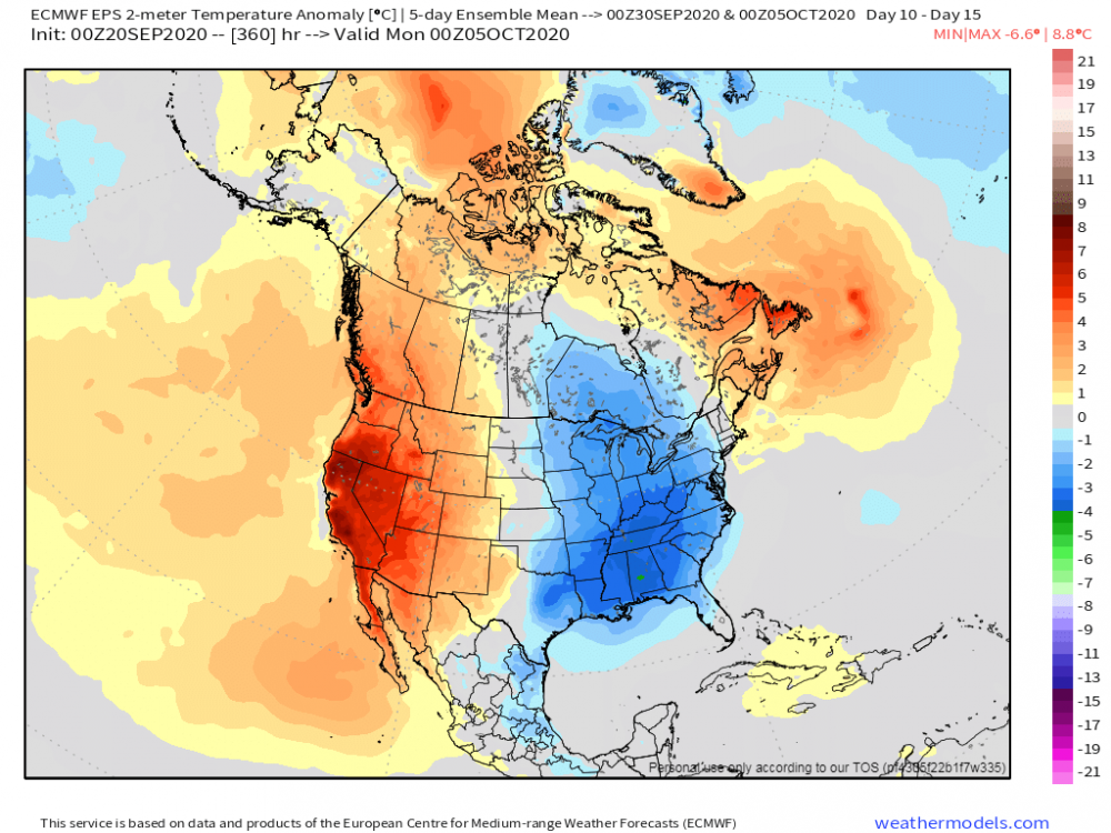
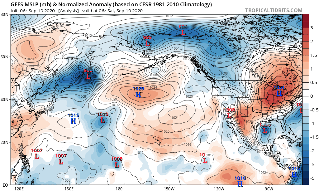
Models are beginning to pick up on a storm system next weekend and a wetter/cooler pattern towards the tail end of the month. 00z EPS, especially, trending towards a highly amplified pattern across North America that may very well deliver the coolest air of the season as we close out Sept and open up Oct. Unfortunately, it doesn't look to deliver a lot of precip for the central Plains and targeting more of the eastern Sub. We'll see how this develops over the coming week. Check out this animation below which shows the rolling 5-day 500mb ensemble mean for week 2. A number of big clues stand out to me as we move into the heart of Autumn. Firstly, the dominant SW Ridge that shows no signs of breaking down. Second, the northern stream energy that dives down SE out of western Canada (typical La Nina signature) into the Upper MW/MW/GL's region. Third, the blossoming Scandinavian Ridge and Greenland Block which leads to an expansive eastern CONUS trough. This, my friends, is a pattern to which we have not seen since for a few years to open up October. It appears to me that we have bucked the trend of recent Septembers and this cold season may in fact do just that for the eastern CONUS. The N PAC pattern that has developed this month and dictated a lot of what is happening now surely looks to continue. The BSR would suggest so...back on Sept 14th there was a very strong Bearing Sea storm system that spun up and slowly tracked E/NE in the Bearing Sea. This would correlate to a big storm traversing across the northern Sub with a trailing CF sometime during the opening days of October. A glimpse at what exhibit A of the LRC could look like?? Here's what I think would correlate to the 2020-21 LRC's first storm system right around Oct 6th (ish)...look at the 00z GEFS animation below and there is a storm today tracking near the western Aleutian islands and taking a due west/east track suggesting to me we could see a storm develop in the central Plains and track eastward right about the time the new LRC evolves. The pattern looks quite intriguing to me and with blocking in toe, I foresee an active and cool pattern for a lot of us on here to open up October. Pretty neat stuff happening all across the Northern Hemisphere as nature really starts to energize the jet stream.
 2 points
 -
Tom, jaster and FAR_Weather, I love you guys. I appreciate that.2 points
-
I've never made pretense one time that I'm anything but a very imperfect but kind and intelligent man who loves weather. I hope I haven't lead you to feel otherwise and I'm sorry if I have made you feel that way. You're fair, I took one shot recently at the NWS over neglecting a significant cold front when guidance was pretty well settled on it being noteworthy within 8 day range. Ultimately the result was, the temps split the difference between their thoughts and mine. Call it a wash. I have known that at some point a sharp cliff is coming and, no, im not yet sure why the pattern kept reverting back or would retrograde right at the core of winter other than the tropical domain has been incredibly dominant now for over 4 years. Not even NOAA quite has the tropics figured out yet and neither do our GFS/CFS as noted often by their revisions and sudden cat 4-5 hurricanes. I think I'm justified. I'm just a hobbyist that loves and really cares about people. If you really want to know the truth. God bless you. I make mistakes, but I'm willing to learn, its how we learn sometimes through effort, frustration, adversity and more. I hope I never stop learning because it would mean that I quit trying.2 points
-
Glad to hear her symptoms are mild so far! We’re having beautiful but boring weather here as well. The grass is mostly nice and green, but there still are some small cracks in parts of the lawn, etc. I’m still in the abnormally dry area on the drought map. Just a few miles north and southeast had better rains during the summer, so they’re in better shape. Could use another 2” of rain now. Today I was in nw. C.R. with a group of guys helping with storm cleanup. We were cutting down some badly damaged trees in someone’s backyard and cutting them all up. Some were large trees so we didn’t get it finished. There’s no decent access to the yard so I think they plan to just let the piles of wood rot. People from my area are going up about every week. Anyway, I got a good workout and I’m tired and kinda sore.2 points
-
Attm, 61F under mostly sunny skies. Dew is an incredibly dry 39F, which, enables you to write your name on your skin w your own finger. Just finished a massive work-out, including an intense cardio, so I am now about to do some (yes, paperwork in my homeoffice, which neva seems to stop, right, even on a Sunday..UGH). If time permits today, I might take advantage of a aggressive bike ride up the hills. Note: Medicane, also referred to as " Mediterranean cyclones," did some major damage to the western and northern parts of Greece. Luckily, my properties are on the far eastern side, so nothing really disruptive occurred on that part of the country. Very rare to experience that type of weather in that part of the world, but they do sometimes happen. Few rare occasions, some huge storms have been observed reaching the strength of a Category 1 hurricane. Friends and family sent me video and could not believe my eyes. Flooding was more than 2 meters. Btw: don't forget, Tuesday of next week, September 22nd, 2020 at 9;30am, "Autumn" arrives.1 point
-
I love seeing these picturesque signs of Autumn...Frost and rising steam off the lakes and ponds...

 1 point
 -
The low bottomed out at 39 here at my house. That 39 was also the official low at GRR. At this time it is sunny and a cool 41 at my house. And yes I had to turn the furnace on this AM for the 2nd time this month. I think it could be time to shut down the AC and put the winter covering on as I don't think it will get warm enough for the AC until next May or June.1 point
-
I did it in September in those 3 years also, vs November 1 like most of those last revision maps that Jaster shared. I'm going to research the 2015-2020 weather period for a really long time if I can because there's probably so much missed stuff in it and a lot to learn. It's been a truly unusual era in weather/climate.1 point
-
Went out for some photography today, and the colors were near peak The leaves changed FAST. Last week they were still mostly green.1 point
-
Not a fall or winter guess but just looking as some average last and first events at Grand Rapids. As we are now past the half way mark of September 2020 I thought it would be a good time to take a look as some upcoming first and last events at Grand Rapids. The average last 90° day at Grand Rapids is August 23rd the earliest last one was on June 10, 2000 the latest was on September 29, 1953. 1951 and 2014 did NOT have a day officially reach 90 at Grand Rapids. Last year the last day was July 20th and this year GR had 16 days of 90 or better with the last one on August 26th The average last 85° day is September 14th the earliest was on August 12, 1989 and the latest was on October 21, 1953. Last year the last one was on September 21st The average last 80° day at Grand Rapids is September 30th the earliest was on August 28, 1918 the latest was on November 1, 1950 Last year it was on September 30th The average last 75° day at GR is October 13th the earliest was September 15, 1981 the Latest was on November 6, 1975 Last year it was on October 1st The average last 70 day is October 24th the earliest was October 1st 1925 and the latest was November 23, 1931 last year to was on October 10th The 1st 32° low that will signal the end of the growing season. Before I get to that I will remind everyone that the last 32° low last spring was on May 13th and while there was a green up Grand Rapids also had lows of 26 on May 9th and lows of 29 on the 8th and 12th So the official start of the 2020 growing season was on May 14th At Grand Rapids the average first low of 32 is on October 13th The earliest was September3, 1946. The Latest was November 14, 1918. Last year it was on October 18th For a killing frost of 28 the average is October 28th The earliest was on September 23, 1974 and the latest was on November 29, 1948 Last year it was on November 5th For a hard freeze of 25 the average is November 8th the earliest was on October 3, 1974. The latest was on December 23, 2001 (talk about late) Last year it was on November 6th And for snow fall. The average that the first 1” snow fall occurs on is November 19th the earliest 1” snow fall was on October 12, 2006 the latest was on December 23, 2011. Last year it was on November 11th For a 3” snow fall the average first one is on December 5th the earliest one was on October 19, 1989 the latest was on March 16, 1949 Last year it was on November 11th when 5.5” of snow fell. This past week we had a lot of high-level smoke and that made the sky look a pale milky white on several days. It more than likely also held the daytime temperature down.1 point
-
Here is hurricane "Teddy" in the open Atlantic heading close to Bermuda and then "Atlantic Canada." Currently a Cat3.....1 point
-
I kinda feel like if October is cold and snowy, there's going to be a bad DJF. I remember some of the best winters being out on the lake in early November on a jet ski on a nice day, and then a week or two later it's under 28f long enough to cover the ski hill in snow. Kind of like someone just flipped a switch and went, "hey buddy it's time to get off the water and get on the snow." Last year we had that early snow on Halloween (IIRC) got a nice cold snap, and then everything until Christmas was foobar. I remember because Alpine Valley blew snow first cold chance they got (their earliest opening over, I was out of town because they never open that early), and some of the other places waited. The places that waited barely made it open for Christmas season. A very nice cold snap in the second or third week of November is perfect for making snow and giving me a long season.1 point
-
You’re fine.-1 points


This leaderboard is set to Vancouver/GMT-07:00