
Leaderboard


Popular Content
Showing content with the highest reputation on 09/29/20 in all areas
-
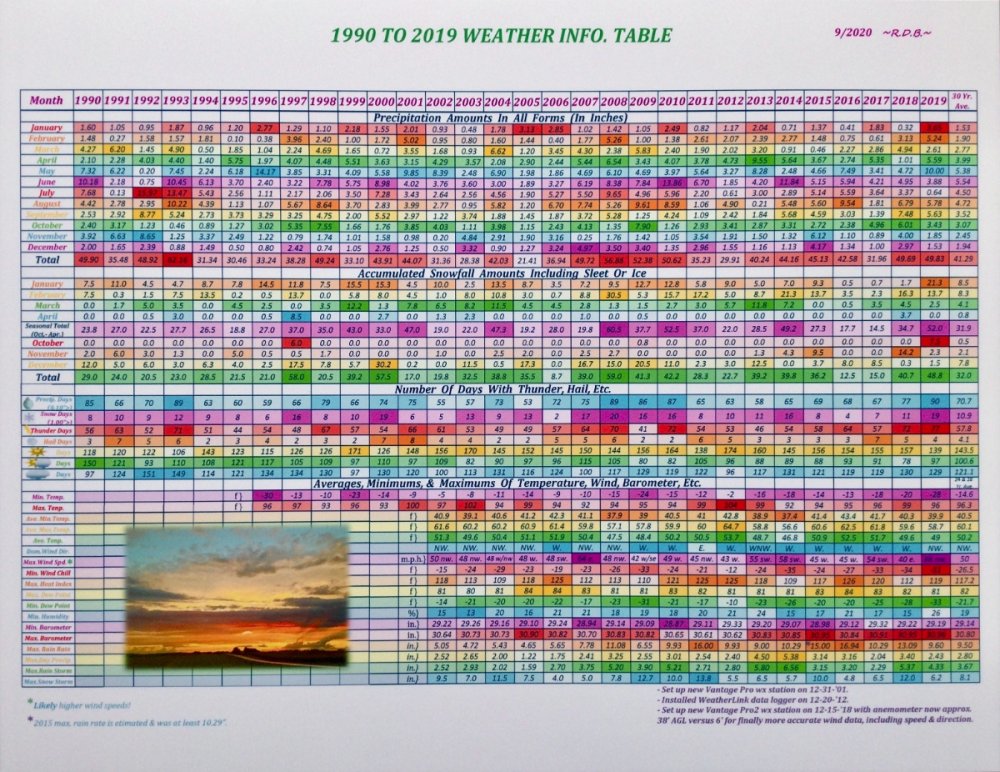
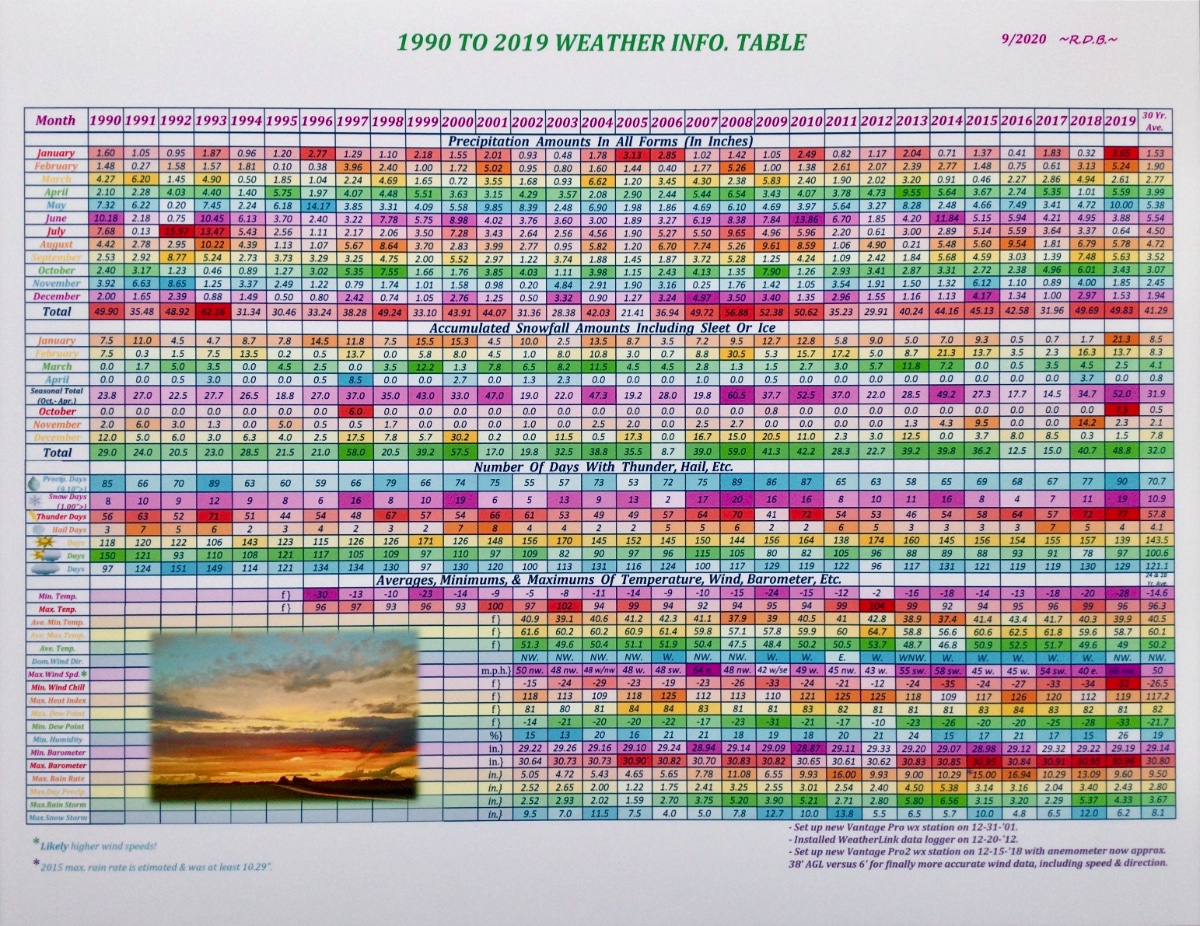
Another nice cool fall day here. Trees are slowly turning. Here is an updated table I made of precipitation etc at my location since 1990. In the earlier years I didn’t record as many different things. For some reason I wasn’t as interested in tracking temps in the 1990’s as I am now. Sadly, I didn’t even have a high/low thermometer till 1996. I also make other types (monthly/yearly) of tables, charts, or graphs. Not sure how well this will show up as it’s only a photo of a printed sheet. The brighter/darker colors equate to wetter, hotter, colder, etc. Edit: Bummer, the images don’t appear very sharp on here. Oh well. Good enough for now.
 3 points
 -
It's a chilly and calm morning with a temp of 46F. Instability showers are in the forecast today as the NW Flow continues. Indoor temp down to 66F but I'm not biting yet to turn on the furnace. Might wait till the Thu-Fri period when the real chill hits the region. Happy "National Coffee Day"...cheers to everyone who enjoys their morning cup of coffee!3 points
-
Seems my CWA has the most action attm. Just getting hammered by CFs! Here's a nice AFD outta my office: Area Forecast Discussion National Weather Service Grand Rapids MI 330 PM EDT Tue Sep 29 2020 LATEST UPDATE... Synopsis/Discussion/Marine .SYNOPSIS... Issued at 329 PM EDT Tue Sep 29 2020 -Periods of showers and tstms tonight through Thursday -Frost/Freeze potential Thursday night and Friday night -Rain system Sunday && .DISCUSSION...(This evening through next Tuesday) Issued at 329 PM EDT Tue Sep 29 2020 -- Periods of showers and tstms tonight through Thursday -- Expect an active/unsettled pattern the next couple days as axis of deep upper trough impacts the Great Lakes Region. While showers will be possible at any time due to the cold, unstable cyclonic flow off Lake Michigan, some features of interest that will ramp up the coverage/intensity of showers at times and lead to some tstms include: 1) Tonight... A sfc trough moves west to east through the region. Enhanced low level convergence with this feature as well as an increase in lake induced capes by midnight should lead to some locally heavy downpours and perhaps a few thunderstorms - especially west of highway 131. 2) Wednesday...A potent shortwave passes across srn Lwr MI Wed afternoon. This feature, combined with the arrival of the next sfc cold front and some very cold temps aloft (-25C at H5 and mid level lapse rates near 8 C/KM) will result in numerous showers and some tstms. Some small hail and gusty winds could accompany some of the deeper cells during peak heating. 3) Thursday... the core of the coldest air aloft will be overhead and yet another sfc cold front will be dropping down from the north. This will support another day of numerous showers and tstms, peaking in the afternoon. Lake induced capes are shown by the NAM to be around 1500 J/KG both Wednesday and Thursday. -- Frost/Freeze potential Thursday and Friday nights -- Winds behind Thursday`s cold front shift northerly and usher in a very cold/dry airmass. Any lingering lake effect rain showers should become situated at the immediate lakeshore or just offshore. Clearing skies and diminishing winds Thursday night may lead to a widespread frost. Even colder overnight lows are forecast on Friday night as sfc ridging arrives, with a freeze likely north of M-46 and frost likely elsewhere. -- Rain system Sunday -- Guidance continues to trend farther north and wetter with the system on Sunday. This may be a chilly all day rain type of system aided by a closed upper low. The showers may linger into Monday as well. && .AVIATION...(For the 18Z TAFS through 18Z Wednesday afternoon) Issued at 156 PM EDT Tue Sep 29 2020 VFR with only isolated showers/MVFR cigs this afternoon and early evening, then numerous showers and associated MVFR conditions developing for about a 6 hour period tonight (roughly 03Z to 09Z). This occurs as a sfc trough passes west to east through the region. Some IFR is also possible in any heavier showers that occur later tonight, with the best chance of that happening at MKG and GRR (where even a tstm cannot be ruled out either). After a brief lull in shower activity and extent of MVFR early Wednesday morning, more showers developing again by 14Z-15Z, along with gusty west-southwest sfc winds to 25 kts. A few tstms are also likely on Wednesday and some could contain small hail. && .MARINE... Issued at 329 PM EDT Tue Sep 29 2020 Have extended the Small Craft Advisory through Thursday as cold cyclonic flow and a series of cold fronts continues to impact lake Michigan. Persistent westerly flow reaching 30 kts at times with waves averaging 3-6 feet, sometimes higher. Prime waterspout set-up will be present over Lk MI the next 48 hours, with convective cloud depths of 20-25K ft and the water to 850 mb temp difference in excess of 15C. This yields high values on the Szilagyi Waterspout Index. && .GRR WATCHES/WARNINGS/ADVISORIES... MI...None. LM...Small Craft Advisory until 8 AM EDT Thursday for LMZ844>849.2 points
-
Nice table there. Was going to compare snowfall but I see it is by year vs season. Makes it a bit challenging. Do you have a list of snow totals by season as well?2 points
-
Good job! Its the effort that you put into that counts.2 points
-
Dittos for this guy, friend. Yesterday's high of 56F was 24 degrees colder than Saturday's 80F. Add in the contrast between overcast/damp/rainy and wall-2-wall sunshine and the contrast was stark. Not that a 24 deg drop is that huge (heck, that's a hourly obs for our Plains peeps) but it's nice to see autumn temps to finish our BN September in style. Should be a top-shelf day on tap with sun and low 60s around here. Trees are really noticeable already. Well ahead of schedule and especially noteworthy with all the recent frost-less autumns around here.2 points
-
Wow...looks crazy!!!2 points
-
On my morning walk, it felt kinda chilly and my hands got cold actually. It's also wonderful to see how much brighter the mornings are now without the smokey skies. Atm, there are pristine blue skies with a slight wind out of the NW and there was a heavy dew on the grass. Many trees starting to slowly change color.2 points
-
Thanks for allowing us to see who reacts posts again, Fred!2 points
-
LOL @ GFS showing a snow swath across N. IL for 5-Oct. Anyone in a betting mood?2 points
-
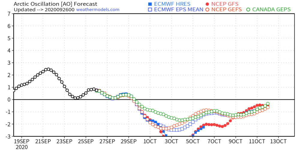
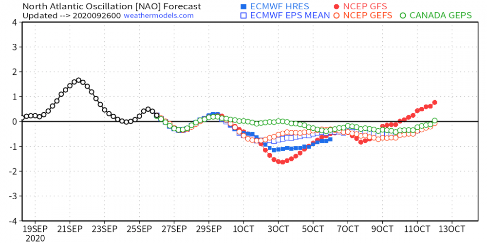
As we wrap up the month of September early next week, we will enter one of the more important months of Autumn that provides us clues what mother nature will have in store as we get deeper into the colder season. Some major changes in our wx pattern are dialing up as we open up a brand new month. Significant high lat blocking seemingly develops right at the start of the month as the new LRC develops, first, way up north in the high lats (good sign) and then trickles down into the mid-latitudes about a week later. What are the models showing??? Let's discuss.... The clues I saw long ago were beginning to present themselves about 10 days ago when I saw the warming developing across Greenland and the northern tier of North America at the 10mb/30mb Strat level. Low and behold, all the models are jumping on the -AO/-NAO pattern. Take a look at the animations below and its really encouraging to me to see that literally ALL the warming ongoing is happening smack dab over North America! It's fascinating to me that as the new LRC develops it is almost like clock work that the atmosphere "snaps" into a new pattern. The CFSv2 has been holding steadfast on the idea of a western US Ridge (+PNA) and eastern CONUS trough-like pattern. Remarkably, this is quite a different pattern we have seen for the month of October in what seems like ages to me. CFSv2 temp/precip trends... On the topic of High Lat Blocking, every single model is picking up on a massive and long lasting Scandinavian/NW Russia Block across the Pole on the other side of the Northern Hemisphere. If this is a pattern that cycles through and one of the LRC's exhibits where ridges will develop in the cold season, look out! Lastly, what about the Snow??? Nature is laying down the foundation way up north, as the sun has set this past week in that part of the world. Ol' Man Winter has arrived and has been awakened. While each run may be different, lately, the CFS has been sniffing out a dramatic expansion of snow cover over Canada next month (Euro Weeklies agree) and quite possibly a big cool down for the lower 48 towards the end of the month. Happy Halloween! North America snow cover extent is trending in the middle of the pack over the last decade...
 1 point
 -
Right now CPC's maps show a normal to BN first half around here temps wise with normal precip.1 point
-
Thank you. The row right between the April and October snowfall amounts is where the seasonal totals are listed or in the wider purple colored row. I guess that’s what you’re looking for? I want to try and share a link to my Excel worksheet sometime if I can. When I was updating this I didn’t know if 30 years worth of data would fit on a letter sized sheet decently, but I got it all on there. BTW, Don’t strain your eyes to hard!1 point
-
Before ya know it, these will be snowshowers for your area.1 point
-
The end of GFS is still wrong. It disagrees with its own AO trend. Those of you who are in drought, or starting a drought, this is bad news. If October is showing rainfall to your east in longer ranges, I'd retrograde that west in my mind when thinking futuristically. I guess I'm making my formal disagreement that east of the rockies will be "normal" or above in temps throughout at least October. Folks uo north need to get harvest done at the first opportunity.1 point
-
Currently at a chilly 52F w partly sunny skies. Autumn is showing its presence. Gotta tell ya, sure feels good to be outta this relentless heat from this past Summer. It almost seemed sempiternal. Anyways, thank goodness we are done w that. Big time chill arrives by weeks end. Highs imby may actually struggle in the low 50s on Friday. Everybody, even Detroit goes in the upper 30s to near 40F Fri-nite and Sat. NW burbs will be looking at some frost.1 point
-
I recorded 0.11" of rain here for a two day total of 0.58". At this time it is clear to the south but cloudy to the north. The current temperature is 51.1 point
-
Looks like 70s (above normal) return for me next week. Until then it looks cool with frost potential Thursday night and showers this weekend.1 point
-
2005 reached Zeta.1 point
-
Picked up a few quick showers early in the afternoon and this evening resulting in 0.17” for today.1 point
-
Wow, didn't realize the Nina was going to that strength. I remember some research showing that the extreme ENSO states {both + & -} were not too friendly for SMI. Having said that, recent winters have pretty much tossed any notions of expecting a traditional outcome when adding up all the "drivers" within any given ENSO state. I've seen a full on Nino deliver a cold and snowy winter (09-10), and a winter with a raging +AO bring the historic cold n snow (13-14). We even had a Mega-Nino deliver an above normal snowfall winter with (4) major storms (15-16). Then there's the past 2 winters when the weak Nino failed us miserably. I know there have been some strong Nina's deliver for this region, so I'm not considering this one a "toss". Regardless, I'll take my chances with a strong Nina over a strong Nino any time.1 point
-
Northwest flow1 point
-
Talk about flipping a pattern switch! Overnight we go from endless summer sunshine and benign repeat to active, active, active. Things that are in my AFD for this week: Up to 1" rain, classic autumn stratiform type Brisk north winds High temps 10-15F below normal Cold core thunder Likely waterspouts Lows in the 30s Possible frost1 point
-
Yep, those LR snow maps are the new "clown maps" of our era but you don't need to look any further than last Halloween to find a real snow swath thru the Midwest. Sooo...1 point
-
It's all a 15 year ruse. The guy loves to get wet.1 point
-
My extended for October does not even show a drop of water from the sky. "Bonedry."0 points
-
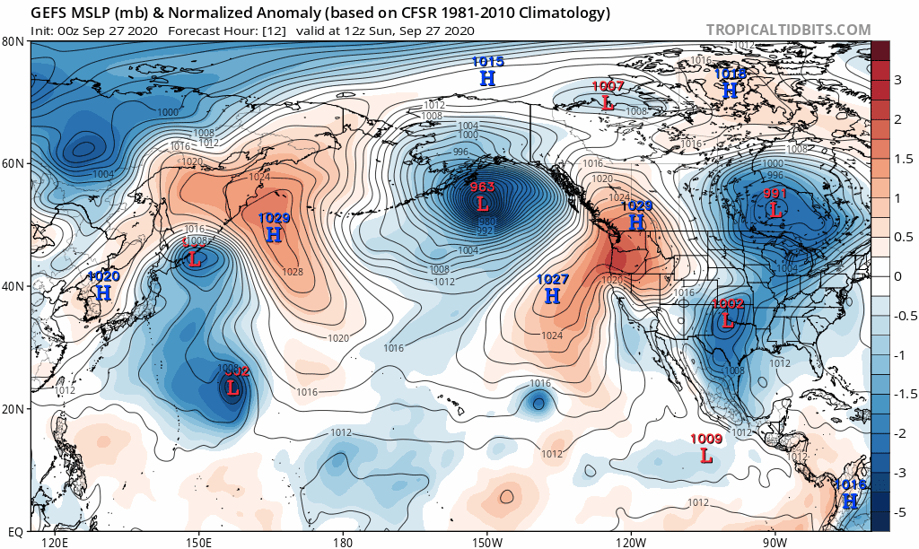
Some LR thoughts on this beautiful Sunday morning...I'm paying close attention to the wx pattern thousands of miles to our NW, near the Gulf of Alaska, where today a powerful and rare early season storm system is poised to thrash the SE coast of Alaska with Hurricane Force winds. My brother and his family have a cabin near the Kena coast where they had some great Salmon and Halibut fishing last month. Over the next week, this part of the North American continent is going to get lambasted by 4 storm systems in a week long barrage. Take a look at the 00z GEFS animation below... Why is this important??? Well, the track to which these storms are taking is critical to our wx pattern downstream as this pumps the ridge up along the western NAMER coastline in the near term. Last year, I remember these storms plowing east into western NAMER, thus pumping a huge EC ridge and very different compared to last year. Now, this is where I think the pattern may be heading towards Week 3-4 of October. The track to which these storm systems are taking suggest to me that we will see a lot of systems tracking up from the south (potential GOM systems) and ride up the App's or EC. Unfortunately, this means those members in our western Sub may not benefit from this pattern come Week 3. We'll see but if the PNA relaxes to more neutral by then it may allow a farther western storm track through the MW/GL's during this period. I'm thinking there will be a very active period by Week 3 and a persistent Long Term - Long Wave trough across eastern North America. This could be the chilly pattern both the Euro Weeklies and CFS model are seeing towards the later part of the month.
 0 points


This leaderboard is set to Vancouver/GMT-07:00