Glacier
-
Posts
80 -
Joined
-
Last visited
-
Days Won
1
Glacier's Achievements
")


-
 Correction: Lytton's record is actually 121.3F/49.6C! So you're WAY off!
 -
Canada is Burning
Glacier replied to AquariusRadar's topic in Climate, World Weather, and Earth Sciences
Western Canada/US is going to get lit up like a Christmas tree this weekend. According to models anyway. -
UPDATE: A new record was set for June in 2015. Therefore, the all time record highs for June are: 1) Hedley = 108F/ 42C in 2015 -- Boston Bar = 42C in 1987 (this one is probably a little high) 3) Trail = 106F/ 41.1C in 2015 -- Lytton = 41.1C in 1942 5) Oliver =41C in 2008 6) Osoyoos = 40.9C in 2015 7) Ashcroft = 105F/ 40.6C in 2015 -- Lillooet = 40.6C in 1925 -- Cumberland = 40.6C in 1942 -- Barriere = 40.6C in 1938 -- Woods Lake = 40.6C in 1925 12)Revelstoke = 104F/ 40.1C in 2015
-
105F is very common in the interior, especially in the Fraser Canyon around Lytton. It doesn't occur every year, but almost, and BC is almost always the hottest place in Canada. Hot temperatures occur because of stable high pressure systems that set up in the summer, which draws up hot dry desert air from the southwestern US. Here is a list of the year by year extreme temperatures in Canada... https://en.wikipedia.org/wiki/List_of_extreme_temperatures_in_Canada#Yearly_Canadian_temperature_extremes
-
UPDATE: I just realized that the Puntzi Mountain weather station was still in existence throughout the 1980s (source here: https://weatherspark.com/h/y/145177/1985/Historical-Weather-during-1985-at-Puntzi-Mountain-Airport-Canada) Anyway, during the extreme cold snap of November, 1985, Puntzi Mountain bottomed out at -47.9C, so it is Puntzi, not Smith River that holds the November provincial record.
-
Unusual weather trivia that is hard to google
Glacier replied to Scott's topic in West of the Rockies
In 2009 here in BC it was over 41C/106F in Vancouver Island. Even on some of the cool outcrops and lighthouse stations it was near 90F. While the coast is normally cool, once in a while you get strong outflow winds from the interior, and downsloping causes temperature records to be broken by 5 or even 10 degrees. Take for example Bella Coola on the central coast of BC. The hottest it has even been at the airport since records began 1983 was 36.3C/97F. In 2009, it was 41.2C/106F. That's 9F hotter than it's ever been, and the record is totally legit. To the west of this place on northern Vancouver Island at a place called Gold River a temperature of 41.5C was recorded (temperatures rounded to the nearest 0.5C at that station). Many places shattered the all time records on the coast including the likes of Kitimat on the north coast, while communities in the interior that frequently hit 40C/104F reached what they'd normally achieve in a typical year. So, yes, one-off records on the Alaska coast can be legitimate records. -
Unusual weather trivia that is hard to google
Glacier replied to Scott's topic in West of the Rockies
I was working on a blog post last year about the hottest day in Yukon history (but forgot about it until now), so I just looked at the draft and extracted this section. I will have to finish it off sometime when I find a few minutes to spare. Here's a draft excerpt: Since 1950 the Yukon has been able to hit 35C/95F seven times. Interestingly, the all time high was hit 10 years ago, and no one noticed. Environment Canada and the Yukon government says that the all time record was recorded in June of 1969 when 36.1C (97F) was recorded at Mayo (interestingly a mere half a year after the coldest winter on record) . Aside: We see this same pattern in other places like the prairies in 1936 where the coldest winter on record was followed by the hottest summer on record. Here is a list of the other hot spells that hit 35C. - June 1950 when Dawson and Mayo were 35C/95F, - July 1951 when Mayo was 35.6C/96F, - May 1983 when Forty Mile was 36C (96.8F) [i'd consider this a tie with 1969 since temperature was rounded to the nearest 0.5 degree C instead of the nearest degree F prior to the 1980s], - July 1998 when Mayo Road was 35C (95F), - June 2006 when Drury Creek was 35C (95F), and - July 2009 when Watson Lake was a record setting 35.4C (95.7F). (This was the same time that many places further south in BC set all time records such as Vancouver, Terrace, Comox, and Abbotsford). There was one more, and that was June 2004. In that month Mayo Road was 36.5C (98F). This was the hottest temperature ever recorded in the Yukon, and while the heat wave did get a lot of press for number of days above 30C, no media outlet picked up on the fact that this was a new record setting temperature for the territory. -
Unusual weather trivia that is hard to google
Glacier replied to Scott's topic in West of the Rockies
What do you have against the 1915 Fort Yukon record? Fairbanks, Circle, and Eagle Alaska often climb above 90F. Just doing a quick look at Dawson, Yukon from 1915, it didn't even hit 90F/32.2C in 1915, so hitting 100F seems at first glance to be a bit preposterous, but still, they are a couple hundred miles apart. EDIT: I found this: https://www.wunderground.com/blog/JeffMasters/baked-alaska-98-reading-ties-alltime-state-heat-record.html -
It's not a myth, but there are a lot of myths that have been attributed to it. Global Warming/ AGW/ Climate Change is the theory that human caused emissions mean that the planet is warmer than it would be if we were still living in the stone age. Beyond that, it's mostly myth. People think that human caused warming is bad, but natural warming is good (naturalistic fallacy). People think that all the consequences of warming are negative while ignoring the positives. ie. change is bad (appeal to tradition fallacy). People think that the warming of the planet is accelerating. When you call them out on it with science and data, they invoke the appeal to authority fallacy by claiming someone with more important title than you disagrees (even though they cannot actually cite the person's statement on this). People think that the only solution to the warming is Marxism, and thus have no time for scientific inquiry and cost-benefit analysis.
-
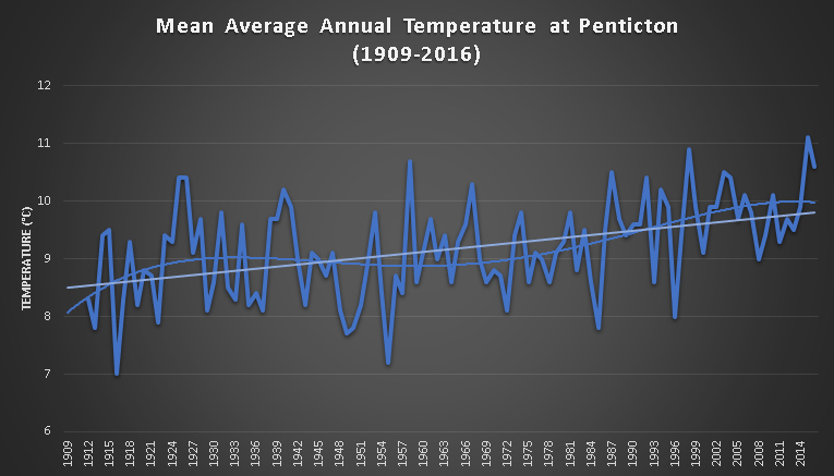
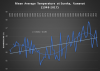
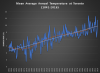
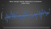
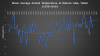
EDIT: Sorry about the typo in the title... I changed before hitting submit, but forgot to remove the second "is". NB: This is NOT a refutation of man made climate change. All I'm asking for a someone to show me a single weather station anywhere on earth that shows accelerated warming. I ask because the radio mentioned yesterday how warming is accelerating. I've had friends tell me it is. I've read articles about it, but when I graph the data myself, I cannot see any evidence whatsoever that shows this. Let's start with the premise that climate change is real, or least that it's immaterial to this topic. I don't care about that. I just don't like it when the news media lies about easily falsifiable facts. If climate change is real, then the facts should stand for themselves, and lying should not be a valid method for convincing the skeptics, so surely, there is accelerated warming somewhere. Here are 4 stations in Canada that I've graphed for the fun of it to get us started. I will do more in the future until I find this elusive accelerated warming.
-
I can't speak for California, but here in BC our valleys that get up to 25 days per year above 90 are so narrow that if you adjusted for elevation, you wouldn't even see these areas since 10 miles away east and west (or north and south) never hit 90 degrees.
-
I think it should be based entirely on vegetation (and equating vegetation with similar growing requirements). There are just too many factors to classify climates with measured variables. In addition to temperature, precipitation, and the like is latitude. For example, at Clinton, BC (51N) you have ponderosa pine growing all over the place even at above 3000 ft, but you go up to Williams Lake (52N) where it's warmer and drier and more conducive to ponderosa on paper, you don't get ponderosa because it's too far north.
-
A massive dump of snow near the water does not necessarily equate into a massive dump inland. On the contrary, I would say that it would have been one of those events such as across the water in Victoria in February 1916 or December 1996. Usually when a low elevation location gets record amounts of snow, the higher elevations don't.
-
Well, another climate heretic has been shown the door for daring the question the orthodoxy of the dangerous climate change all around us. Philippe Verdier, weather chief at France Télévisions, the country's state broadcaster, reportedly sent on "forced holiday" for releasing book accusing top climatologists of "taking the world hostage" http://i.telegraph.co.uk/multimedia/archive/03472/Philippe_Verdier_3472801b.jpg http://www.telegraph.co.uk/news/worldnews/europe/france/11931645/Frances-top-weatherman-sparks-storm-over-book-questioning-climate-change.html
-
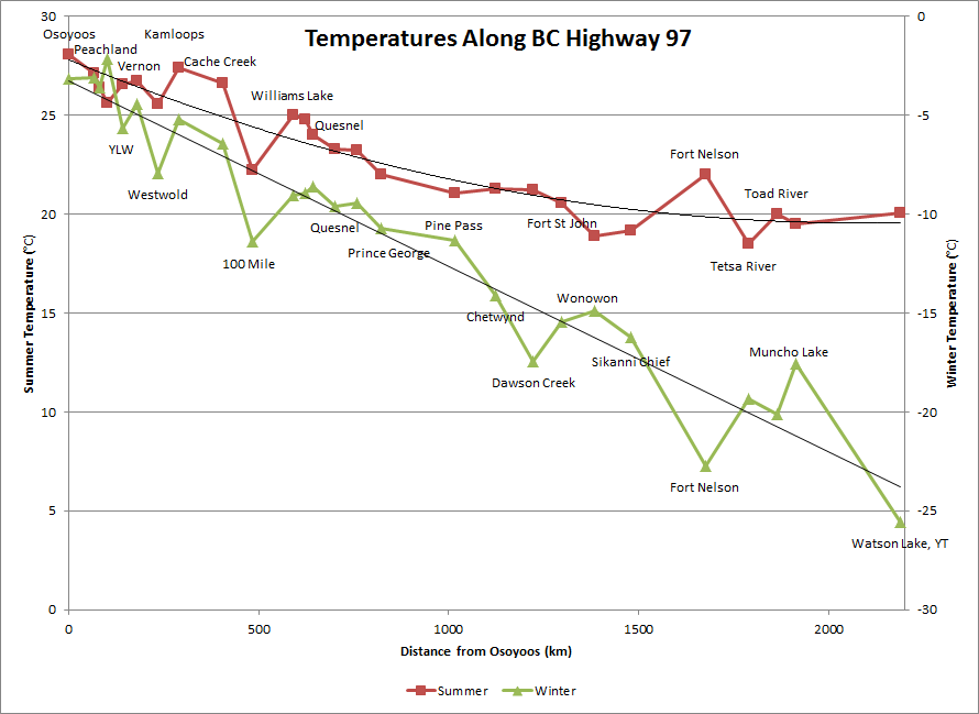
Very nice graph, I will have to update my graph in the future to include elevation. I've driven the Alaska highway 3 times, well 6 times for the 12 mile section between Tok, AK and Tetlin Junction (because I had to come home again), which is why I chose this highway. Another reason is that in the north the low spots mean hotter summers and colder winters. The point where this occurs seems to be around 54 degrees North. South of there, the inversions don't happen enough to actually make the inverted averages in the winter. Here's another interesting thing that I can't seem to explain. The place with the warmest summers in the Yukon is Mayo, and it's quite far north. Whitehorse, Teslin, Faro, Beaver Creek, and Watson Lake are all quite a bit further south, though 100 to 200 meters higher in elevation. Even places with lower elevations further south like the Pelly Ranch are cooler in the summer. It must be the long hours of light in the summer, which could explain why Yellowknife, NWT is warmer at night in the summer than Kelowna (one of Canada's hottest cities). On that note, it seems like cold summer nights peak around 52N. Once you get north of that, the long hours of light keep the temperatures up at night so any cooling the average is greatly reduced, and only continue to get cooler on account of cooler daytime temperatures. Here in BC the only places to get frost in July of this year were in the 51.5N to 54N range. Here's another graph showing the average temperatures along highway 97 from Osoyoos (at the Washington State border) to Watson Lake at the Yukon border (notice that at a certain point the temperature stops getting colder as you go north but the winter temperature does not)...