Grizzcoat
-
Posts
4878 -
Joined
-
Last visited
-
Days Won
16
Everything posted by Grizzcoat
-

Will Chicago receive more snow than Minneapolis this winter?
Grizzcoat replied to Hoosier's topic in East of the Rockies
Yeah not even close. Through April 2nd- both exactly at 60% of normal.
-
The Total Solar Eclipse of April 8, 2024
Grizzcoat replied to Hoosier's topic in East of the Rockies
Not sure if anyone has posted this yet but Pivotal has it's own dedicated page to the eclipse for clouds in ensembles. https://www.pivotalweather.com/eclipse2024/?m=cmceens&p=cloudcover_tle_4-mean&r=conus -
High 79 yday at DSM-- today day high of 45F and brisk N wind.40's feel much colder after a day like yday.
-
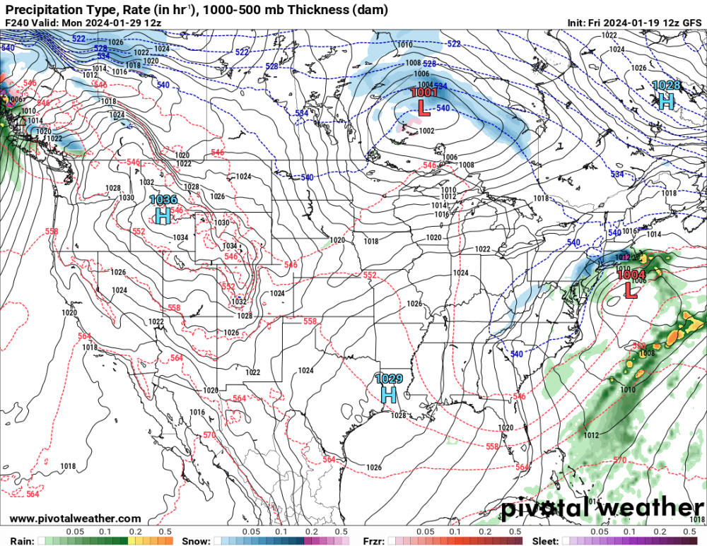
System late next week would cycle perfectly from the system that gave C.IA 1' on the 12th-13th of Jan.
-
34.2" of snow in DSM for the season. 29" or so when it mattered. Winter was not much-- but I'll take a 2nd snowiest Jan all time every year with normal temps. Winter only lasted 2 weeks- but I'll take that epic period over some past El Nino Winters (15-16' etc). Especially when DSM doubles MSP in snowfall. (thus far) . Can't be greedy growing up in MN. Sun angle is now too strong even in MSP for a 6" snow to last much longer than 2-3 days/ unless followed by record cold. Neither is happening. March can produce heavy snows but mainly ND / N.MN in this pattern. Time to flip the seasons into early Spring imo.
-
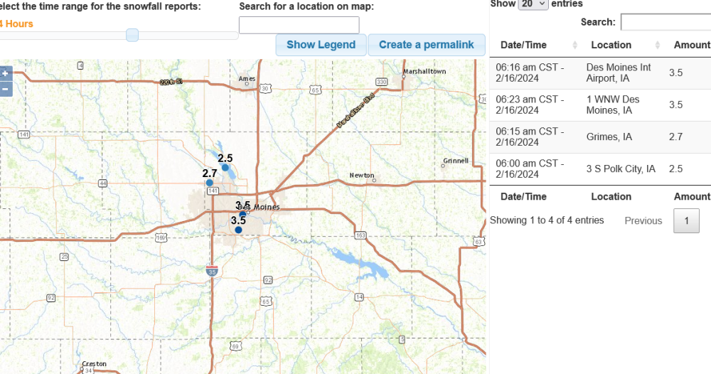
Have had 4 significant snow events since the beginning of the year here in C.IA. 2 of the 4 have seen highest amounts right through DSM proper and that includes the current system with 3.5" as of 6AM. Still snowing. Was supposed to be 1-2" and that was up from 1". Ratios are about 15:1 -- but it started out at 10:1 and is now finishing at around 17:1
-
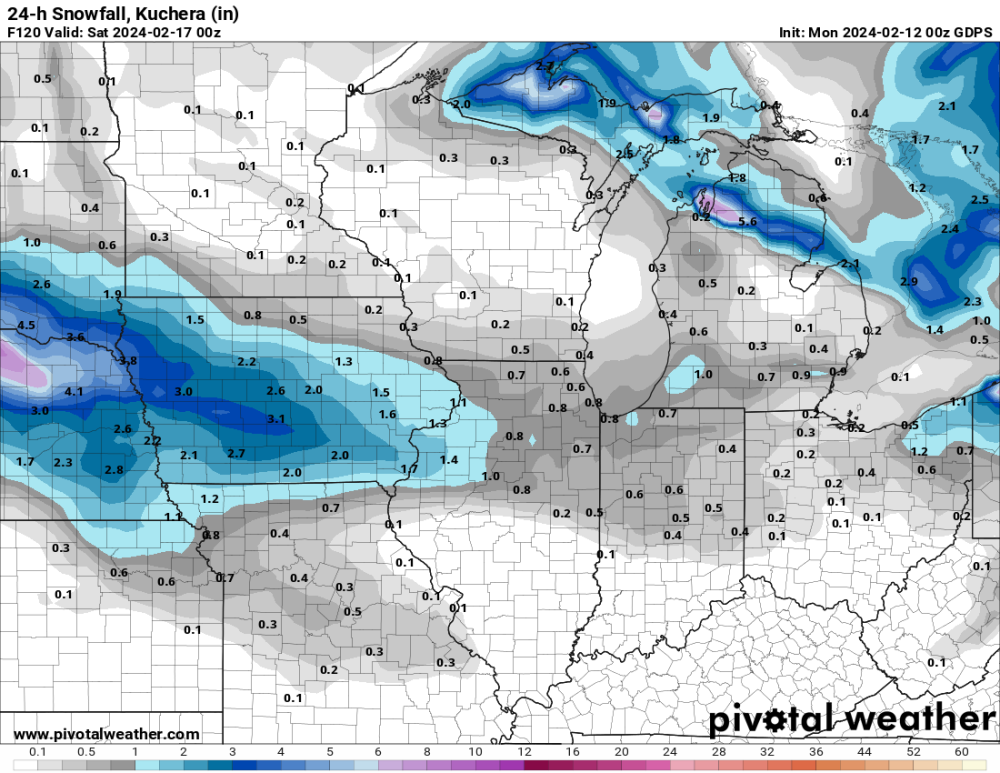
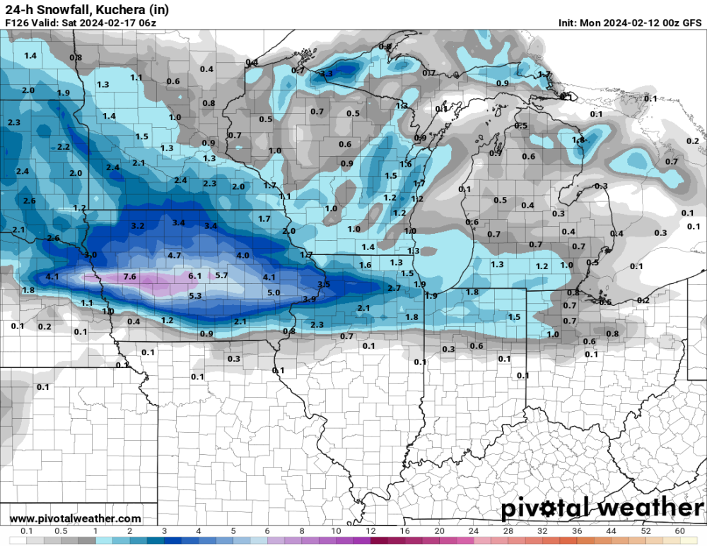
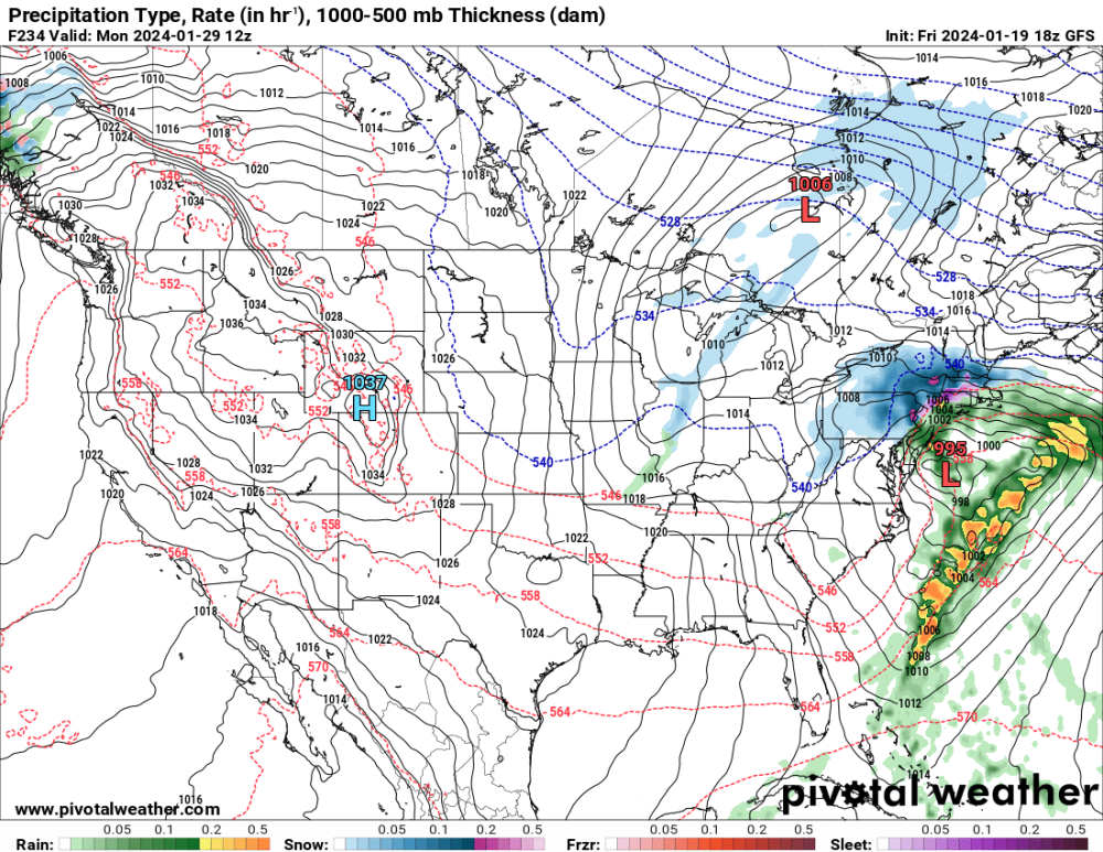
Clearly the 06GFS must be wrong...
-
CMC-
-
Friday system --- would put DSM at full seasonal norms with nearly half of FEB and all of March left. (Everyone knows March is going to be colder than FEB )
-
PDS tornado in S.WI= Tornado Warning WIC025-055-105-090030- /O.NEW.KMKX.TO.W.0004.240208T2350Z-240209T0030Z/ BULLETIN - EAS ACTIVATION REQUESTED Tornado Warning National Weather Service Milwaukee/Sullivan WI 550 PM CST Thu Feb 8 2024 The National Weather Service in Milwaukee/Sullivan has issued a * Tornado Warning for... Northern Rock County in south central Wisconsin... Southeastern Dane County in south central Wisconsin... Southwestern Jefferson County in southeastern Wisconsin... * Until 630 PM CST. * At 549 PM CST, a confirmed large and extremely dangerous tornado was located near Evansville, moving northeast at 45 mph. This is a PARTICULARLY DANGEROUS SITUATION. TAKE COVER NOW! HAZARD...Damaging tornado. SOURCE...Weather spotters confirmed tornado. IMPACT...You are in a life-threatening situation. Flying debris may be deadly to those caught without shelter. Mobile homes will be destroyed. Considerable damage to homes, businesses, and vehicles is likely and complete destruction is possible.
-
Totally agree on those pot hole spots you mentioned. A relative new Coop site is Cotton,MN just N of Cloquet on 33. In a spruce swamp. I haven't checked this year because it's just hasn't been that cold and they many no longer be reporting, but a few years back they were significantly colder than classic spots. I believe -54 or something like that. Who knows what they wouldve been in 1996. Jan of 1994 is another one that gets overshadowed by Feb 1996. It was overall much colder. I believe Crookston had a avg temp of -6F for the entire month. Places in E ND were even colder.
-
I believe Tower was -60F two mornings in a row. Also- some winter campers slept overnight one of those mornings in a swamp near Embarrass. They reported -70F on a thermometer. Not sure what kind but the story is true. I was living in New Brighton at the time and had -34F on a wired thermometer. That's D**n cold for a relatively close suburb of the UHI of MSP.
-
January 2024 Observations and Discussion
Grizzcoat replied to Minny_Weather's topic in East of the Rockies
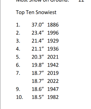
Start and end of month was a dud- but the middle was DOWN RIGHT legendary!!! January 2024 featured back-to-back snowstorms for Iowa, which made up a majority of the snowfall for the month. For Des Moines and Waterloo, that means placing in the top 5 for both the snowiest January and snowiest month of any month! Des Moines 27.2" of snow - 2nd snowiest January (#1 1886 with 37.0") January 2024 5th snowiest month of any month on record Waterloo 25.1" of snow - snowiest January January 2024 4th snowiest month of any month on record -
Need the MJO to get out of it's mini stall in phase 7 and head into 8 and preferably -- 1 and kick this doldrum pattern aside.
-
Interesting tidbit from the Nutrien AG guy video- models really lost clarity right before last Arctic Outbreak and snowy weather in the PLains.May we be going through something similar again?
-
January 2024 Observations and Discussion
Grizzcoat replied to Minny_Weather's topic in East of the Rockies
Look it up. Never happened. DSM being colder than MSP in winter month.Only one summer month -- you guys do the math, . -
January 2024 Observations and Discussion
Grizzcoat replied to Minny_Weather's topic in East of the Rockies
MSP and DSM are fighting for low mean temps in Jan. It's possible that DSM has colder JAN than MSP. Don't wanna go the heat island thing with no snow in MSP; but come on people, this has never happened before. UHI or not-- the climate is changing-- and seems to be getting colder S / and warmer N. -
Yeah- a month ago there were many more clear signals that a serious pattern change was going to start around the 8th of Jan. So much so that I even shared my thoughts that this was going to happen with my non weather Facebook crowd. NO way this time by Feb 10th unless things drastically change. The only model I've seen hint at change is the Euro 360 HR Control and it has been trending more mild of late.
-
January 21-23 Wintry Mix Transition Event
Grizzcoat replied to Black Hole's topic in East of the Rockies
Gotta give NWS credit on this one- the mention of little to no snow was spot on. -
January 2024 Observations and Discussion
Grizzcoat replied to Minny_Weather's topic in East of the Rockies
Say what you will about the long range GFS- but something is going on with it's long range. Anyways, no expert. This guy is pretty good
-
January 2024 Observations and Discussion
Grizzcoat replied to Minny_Weather's topic in East of the Rockies
It's also MUCH different in the longer range. Day 10-12. -
January 2024 Observations and Discussion
Grizzcoat replied to Minny_Weather's topic in East of the Rockies
It may not be correct- but tonights GFS run is MUCH different in the 8-10 day range with a storm and cold air for many. Day 9.5 last 3 runs-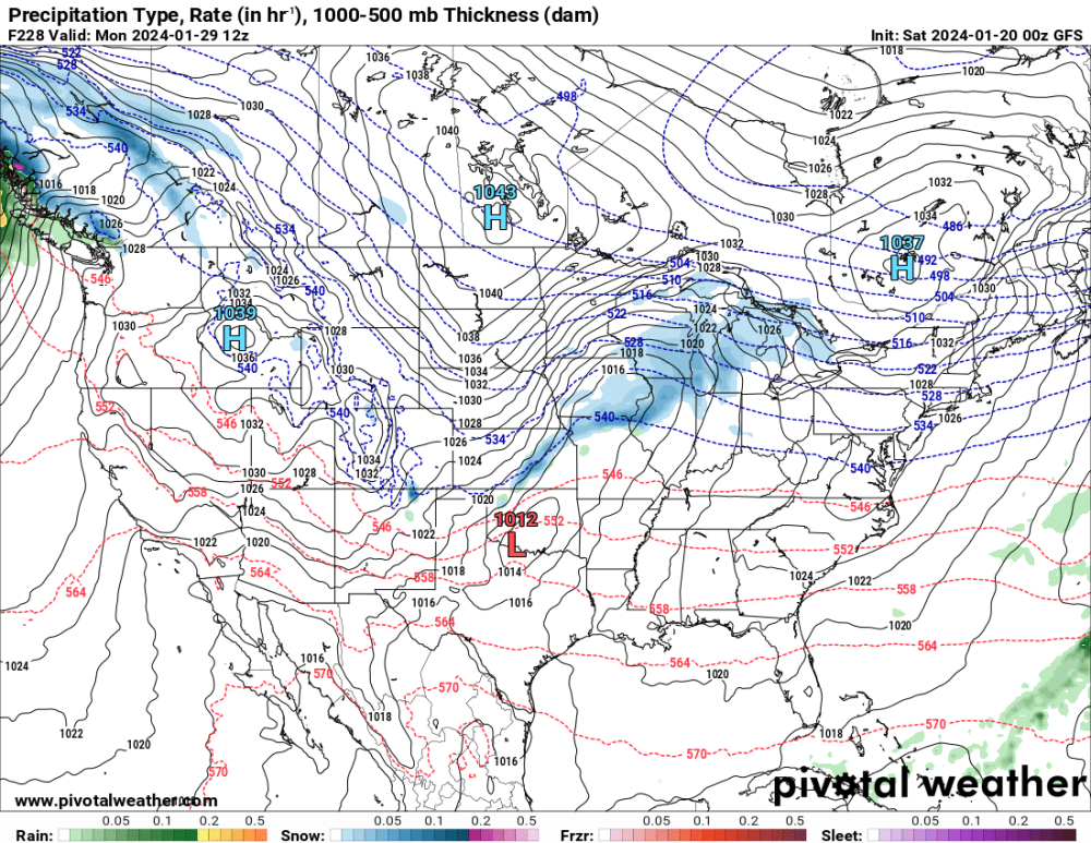
-
January 21-23 Wintry Mix Transition Event
Grizzcoat replied to Black Hole's topic in East of the Rockies
GFS tonight coming in colde aloftr and more qpf for many-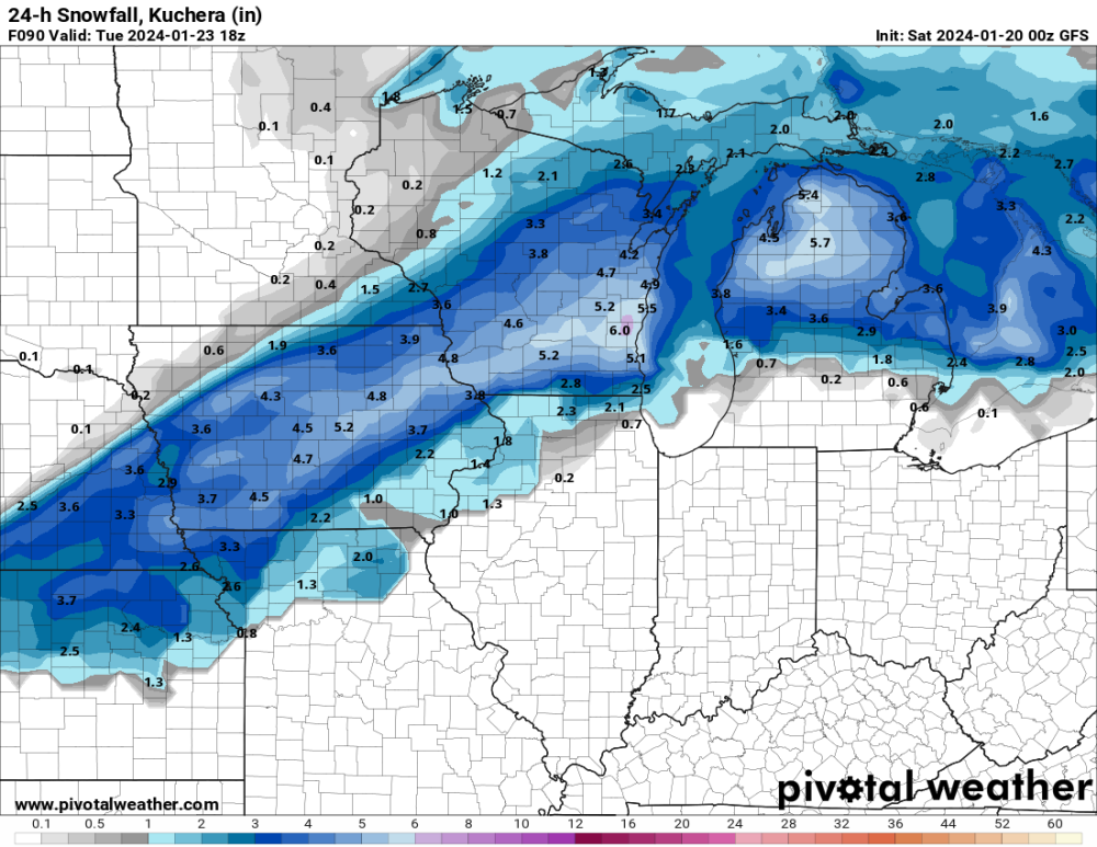
-
January 2024 Observations and Discussion
Grizzcoat replied to Minny_Weather's topic in East of the Rockies
Last 6 Jan's at KDSM for snowfall. Unreal. 2024 is now 27.2: 6 year avg since 2019 is an insane 18.1" or 8.6" above the 30 year avg. That's 6 years of data- 20% of the of 'mean' ( not just a a year or three) -- the new 30 years running mean for - minus some real low JAN's from 25' to 29' = Jan avg snowfall is going WAY up. FWIW -- the following FEB's in these years were no picnic for temp and snowfall. Avg is colder and snowier - esp temp.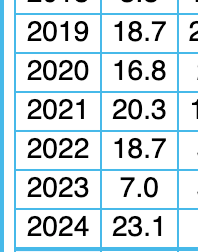
-
KDSM comfortably in 2nd place for JAN with near 27" thus far. Right around 4" at the airport. 4 of the last 6 Jan's are in the top 10 snowiest. Crazy