


OKwx2k4
-
Posts
5470 -
Joined
-
Last visited
-
Days Won
33
Everything posted by OKwx2k4
-

DECEMBER 2023 Observations and Discussion
OKwx2k4 replied to Grizzcoat's topic in East of the Rockies
I believe pretty firmly that this winter holds off til right at Christmas and then it's full-bore into it after that. One characteristic of El Niño of this type is that even in good winters, it's a delayed winter. Winters like 2009-10 are an anomaly with just near-perfect delivery time and again. Same with 2013-14. Those are a rarity. I'd enjoy the warmth while we have it on our side, though. -
We may all well get another two week torch in, but if we go 14-15s route, once we get cracked off, it'll be a 12 week adventure. That's the idyllic "both flavors of Niño" scenario, really. Even though I believe 2014-15 is regarded as a neutral. Some rounds of this pattern include reinforcing cold shots or a blocking effect as well and that is something to keep in mind going into the cold cycle of this pattern later in season.
-
I agree with you guys on the cycle length as well. It's been pretty steady and visible in my opinion. Seeing split camps continue on Niño..... My hat is tossed in the camp of cycling right into a Modoki style Niño. There are mets like Larry Cosgrove who state that the jet hanging further south over Gulf and TX/Mexico insicate a very high liklihood of colder air plunging deeper into the US over the eastern two thirds than would normally see in an East based Niño. I agree with this and have since way back in the summer. Time a surge of moisture here just right and it's fun times. The rest writes itself. While overall winter may not have that wall-to-wall thump, I'm feeling very strong about my thoughts that we will see something very stout cold and white stuff in our future.
-
I haven't said much and won't really add much to the same tune of winter being one that looks to lock all in place right at the right time. Evidence is mounting that my Niño call is a half-bust. While models are consistently showing forcing shifting to the dateline as I'd called for, the overall strength and continued occasional strengthening has continued even in spite of an unfavorable subsurface. I really think @Tom and @jaster220are hitting it on the head. I believe this region has the most favorable track for large, deepening snowstorms and tons of associated moisture. This month having a cold finish will be another positive sign. We'll see how that goes.
-
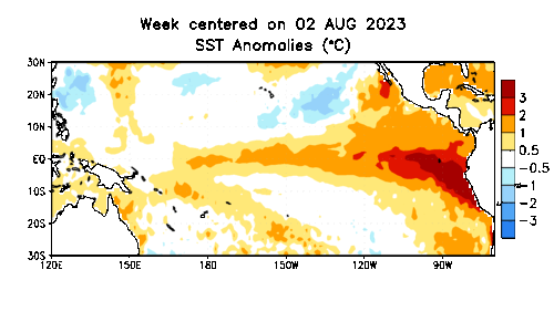
The atmosphere going into autumn. The late July cool spell then the top ten hot November for most of us are all very 2009ish. The other factor leaning to 2009 is the shifting nature of this Niño and where it's forcing are, as was in Bastardi's writing. 1987s Niño was a major east based canonical Niño. 2009 and this one fall in the strong, central/west based category in my opinion based on forcing.
-
Liking the forecasting stuff @Black Hole. I'm still sure that I'd add two years to that blend. 1969 and 2009. Possibly a third in 2002-03. Often, anytime we see Alaska struggling to stay cold, it often signals cold downstream here over the US, so the (first) analogs crashed on that part. Seeing enso start in earnest pulling a modoki-style 2009 shift is another big confirmation that we are probably shifting out of conventional Niño territory. I guess I'd take the pattern advertised in the blend you have, but retrograde it west due to NAO and other variables coupled with Niño.
-
A lot of longer range mets are writing November off as a warm month, but our models and the Euro seem to disagree. The coldest GFS (18z) puts a monster snow down in the day 10-13 range. Not boring at all. Jaster is right. I don't think there is a pattern that keeps the Ozarks in winter all season like the one we have had develop over the last few weeks. We'll be under the brunt of every cold front and it looks like a good healthy amount of backdooring and draining off the plateau if the GLs and interior Appalachians holds the cold down. Verbatim, I get about 4 days of the next 14 above avg before it crashes again.
-
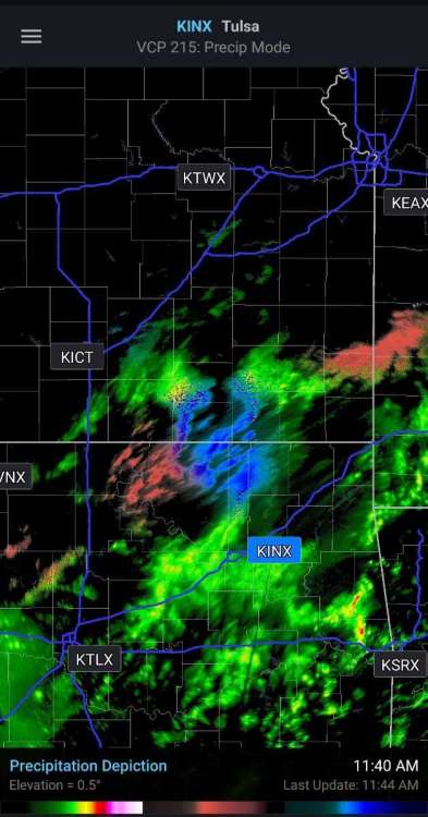
Mixed precip returns showing up on radar north of Tulsa.
-
Yeah. We may even see a taste of winter on the back end of this storm underway at the moment. Also, the trees are just hitting their best colors in some areas.. This year has been a real taste of everything here as far as weather goes. This is the first southwesterly-flow storm I've gotten in a long time. Thats very noteworthy as it indicates a major change in the long-term pattern here. I think winter 2023-24 will be a pretty special one for a lot of us as well. I think a lot of this group is going to be thrilled.
-
Steady and heavier rainfall getting underway this morning. Rather different than yesterday's more warm and humid airmass.
-
Seeing more and more in the winter weather community, both amateur and pro, abandon the bigger Niño calls over the last few days, especially since seeing a PDO flip trying to get underway. Among my favorites are Larry Cosgrove of WeatherAmerica and he's in my camp with a 2009-style winter with breaks. He's stated emphatically that it's not a super Niño style setup at all. I've held this since spring and it's seemed to hold up well.
-
That's pretty wild. I agree. There's not much logic behind that.
-
Not picking up a lot of rain in Eastern OK at the moment, but the wind has kicked it in gear. Rain chances hovering around 30 percent thru tomorrow evening at the moment but after, the moisture will be overwhelming per modeling.
-
That's an absolute blessing. Hoping Louisiana can get in on the moisture as we go forward as well. They're in significant drought.
-
Really glad to see the warm spot forming out by the dateline. Would hope to see forcing follow it as we go through November. Beautiful.
-
I still hold that we will or are already seeing peak in 3.4. 1 is still higher, but at this time, the shift west has begun. Any additional gains in 3.4 are from this as it appears the subsurface is nearly depleted.
-
Location of forcing is as much or more of a factor than total temperature number as well. A cooperative PDO, EPO and AO are all big factors to us folks west of Appalachia.
-
After the next 120 hours, we won't have any doubts about which continent will take the brunt if the cold this winter. What folks need to remember is that cold air doesn't move like warm air does without something to force it out. All bets still on for hard cold this winter in my backyard. Especially Jan-Feb.
-
If it becomes an extremely west based NAO block, the east won't have winter, but the central/interior eastern US will.
-
My fellow okies have covered all the points I came to write on for my area of the region. If ensemble trends are continued, the shot at the end of this month will bring early winter temps to half the state and possibly much earlier snow than normal. The pattern developing and retrograding over the US is how you set up real deal winter.
-
The day before my birthday. How cool. I know a lot of football history but didn't know this one.
-
Jaster covered the BSR pretty well. Just imagine, in modeling, seeing the US over the Bering Sea, then give it 6 weeks or so. You should see a shadow of the pattern repeat. It's why folks talk about hoping to see an Aleutian Low in late summer and fall. It means good winter.
-
If one believes the BSR and its relation to our weather pattern here in the states, its literally a non-stop freight train of lows passing by every run. I'm actually becoming worried about how hard this may get after month's end and on out. This is a solid 4 day cold wave on tap here by October standards and as of right now, I'm on the back edge of where they'd phase at in a southern-branch phasing scenario. There's literally a 24 hour warm up and crashes right back down. Worth noting, for sure if you believe in patterning methodologies for later seasonal forecasting.
-
Models now trending to leaving me cooler than avg all but 48 hours or so of the entire run. That's definitely noteworthy.
-
Still a pretty low amplitude phase as well. Would expect these to increase in amplitude as we go forward.


