Black Hole
-
Posts
2602 -
Joined
-
Last visited
-
Days Won
1
Recent Profile Visitors


Black Hole's Achievements
")


-
 Last spring was boring and dry and this was has shaped up similarly so far, but that looks to change finally! I don't need my house blown away, but a good multi day soaker would really help.
 -
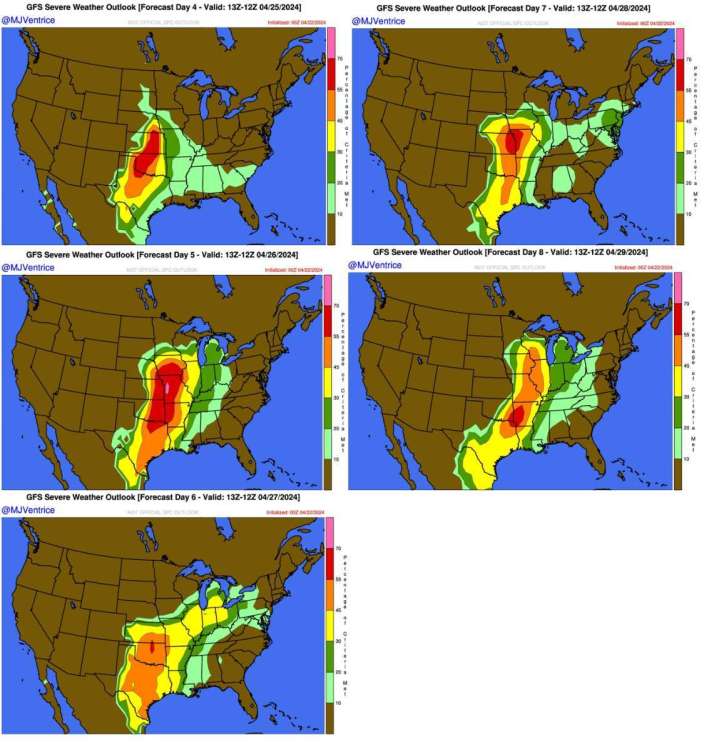
From Michael Ventrice using the GFS
-
April 2024 Observations and Discussion
Black Hole replied to westMJim's topic in East of the Rockies
I posted a new thread for the coming multi day severe weather outbreak. -
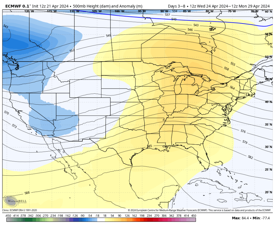
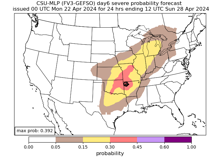
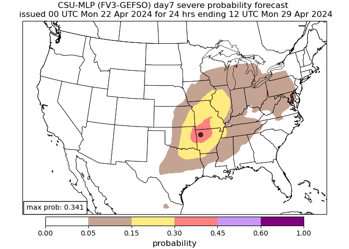
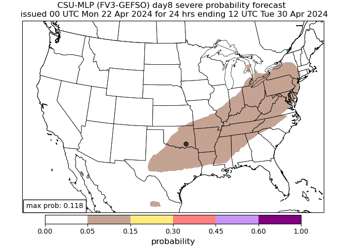
A multi day severe weather outbreak will occur across the southern and central Plains beginning as soon as Wednesday. Persistent troughing west of the area will encourage warm and moist southerly flow with repeated rounds of dry line convection possible. Forecast parameters and pattern recognition show obvious severe potential, potentially significantly severe. It always comes down to the details, but we will have multiple chances for something. For my part of the country, I suspect Friday-Sunday will be our main window but time will tell.
-
https://www.washingtonpost.com/weather/2024/04/17/indonesia-volcano-eruption-ruang/ Paywall, but WP says ash got up to 70k feet. That would probably impact the climate a bit the next 1-3 years. Maybe counteract the warming from the other volcano.
-
April 2024 Observations and Discussion
Black Hole replied to westMJim's topic in East of the Rockies
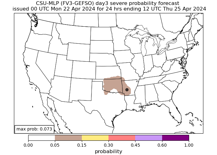
This is looking more lame with time for me. Almost certainly not going to get in on the dry line activity during the day. Some weaker banded stuff may move in overnight but the severe weather threat looks low. I expect this to be dropped to marginal for Tulsa. -
The Total Solar Eclipse of April 8, 2024
Black Hole replied to Hoosier's topic in East of the Rockies
I ended up in Clarksville AR. I went the day of but massive traffic getting out there meant I couldn't go quite as far east as I wanted and the partial was well underway when I got to the park I stopped at. With that said, there were just a few high clouds and overall it was a great viewing experience. It definitely got darker during the eclipse than 2017 since I was a little more under the totality path. I was able to see two prominences, the diamond ring effect on both sides, and the mesmerizing corona. I think the corona looked even better than last time and few pictures can capture how amazing it actually looked. The one in 2045 goes right over my house so if I am still here that will be fun. -
April 2024 Observations and Discussion
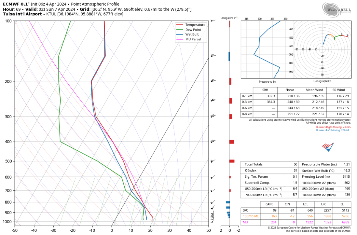
Black Hole replied to westMJim's topic in East of the Rockies
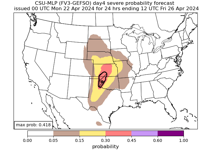
That Saturday night system is looking more interesting. This is a tornadic hodograph with strong speed and directional shear in the lowest levels. The only limiting factor is that low level moisture looks a bit iffy still. But I've seen this enough before to know that a QLCS tornado threat may develop along the front. Otherwise, it just looks like some good rain/thunder. The limited CAPE will not allow for much of a hail threat.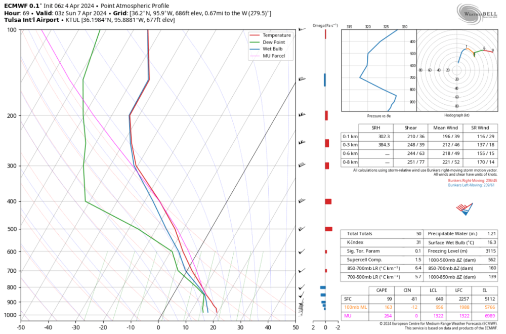
-
The Total Solar Eclipse of April 8, 2024
Black Hole replied to Hoosier's topic in East of the Rockies
I'm not too worried about the almost saturated layer at 850 hPa because the lack of sunshine should limit the low level thermals so presumably there won't be a lot of low level cumulus. -
The Total Solar Eclipse of April 8, 2024
Black Hole replied to Hoosier's topic in East of the Rockies
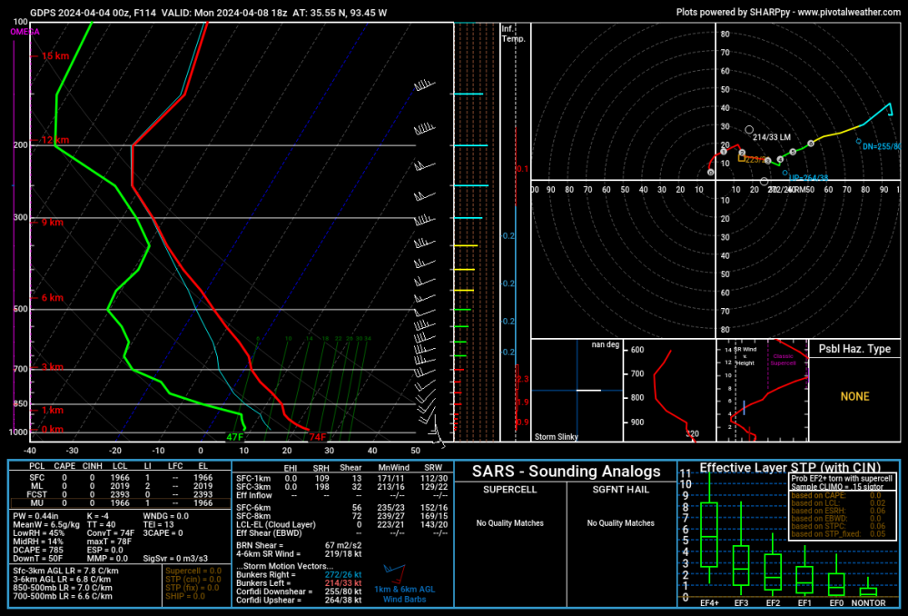
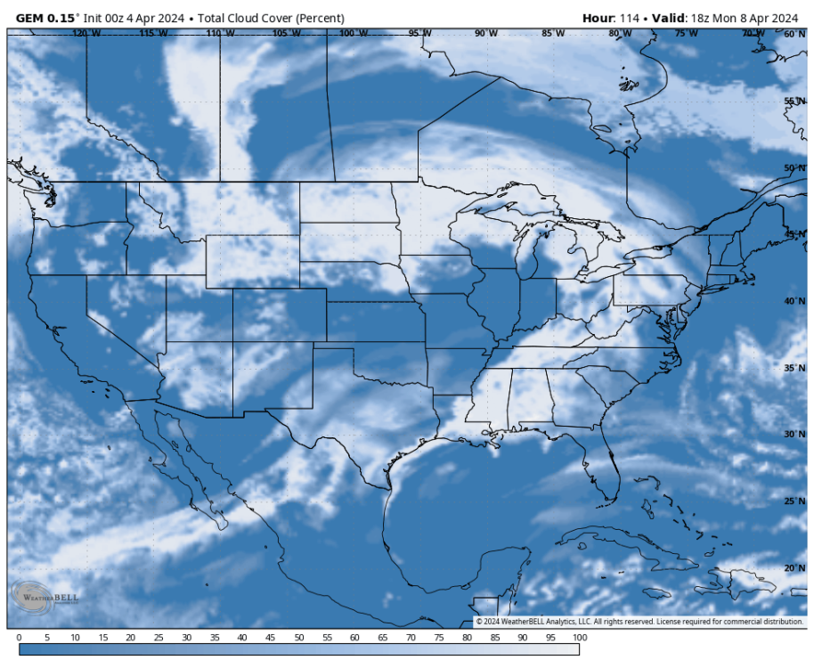
Here are some maps I am looking at this morning. CMC seems to have the most realistic cloud cover. Based on the soundings below (GFS and CMC) I'd say patchy high clouds are likely but the eclipse will be visible in NW AR where I am headed. Plenty of moisture in the upper levels, but upper level height maps show neutral to confluent flow so I suspect light sinking motion will limit the amount of clouds that are able to develop.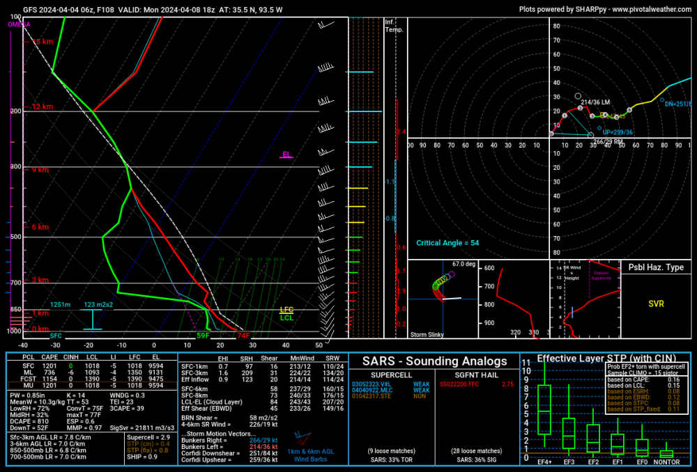
-
The Total Solar Eclipse of April 8, 2024
Black Hole replied to Hoosier's topic in East of the Rockies
Since I live about 2.5-3.5 hrs from a good chunk of the path that's been my plan too, and I am traveling the day of. Probably going to the spot I posted the image for, Russellville, but I could also go south to the Dallas area if its more clear. -
The Total Solar Eclipse of April 8, 2024
Black Hole replied to Hoosier's topic in East of the Rockies
Supposedly the GEFS over forecasts clouds, and perhaps the EPS too. Some in the know are saying the CMCE might be overall the best. If so, its looking decent for viewing in northwest AR.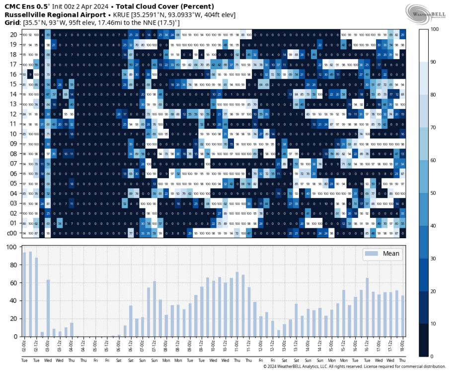
-
March 31st - April 2nd Potent Plains Storm
Black Hole replied to Clinton's topic in East of the Rockies
Nothing severe in Tulsa yesterday, though there was a tornado and some hail damage yesterday about an hour north of town. We got a good squall when the front came through and I had 1.59" at my house. A few way too close lightning strikes too Storm Video I Took If you watch that, there was a huge boom right at the end. -
March 31st - April 2nd Potent Plains Storm
Black Hole replied to Clinton's topic in East of the Rockies
No big changes on tomorrow evening. Dry line storms appear likely with large hail being the primary threat. My best guess on timing is 6 to 9 PM. We will see!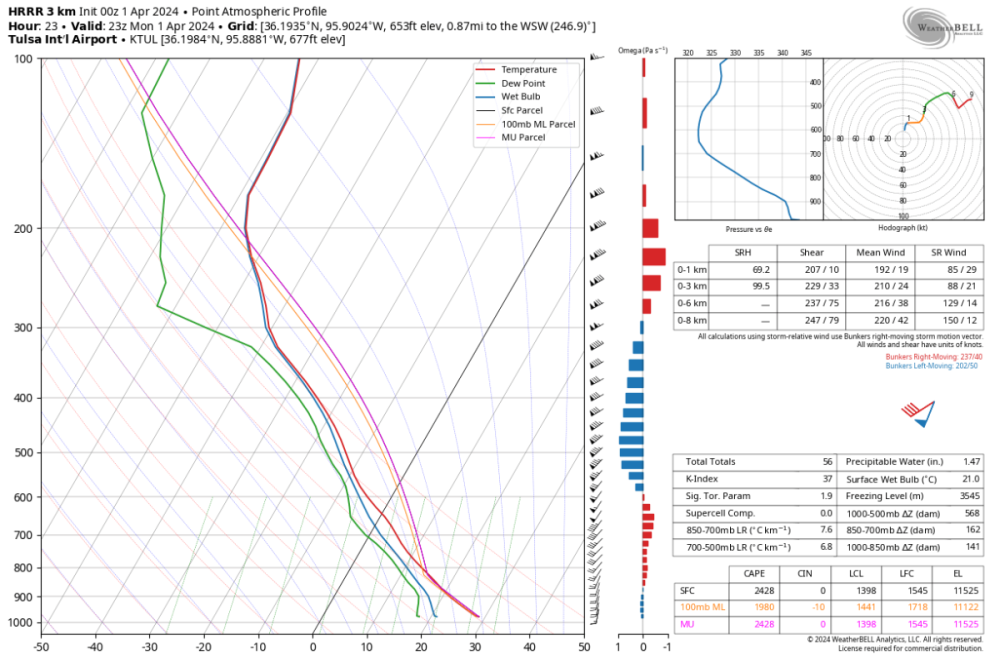
-
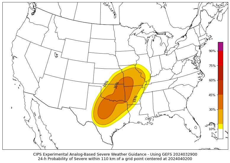
March 31st - April 2nd Potent Plains Storm
Black Hole replied to Clinton's topic in East of the Rockies
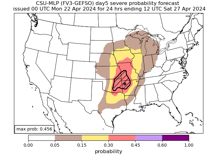
Here is the CIPS analogs, which are similar to the SPC. At least for my area, it looks like mostly long straight hodographs, which will favor splitting storms. Lapse rates are excellent and the temperatures aloft are cool so large hail is probably the biggest hazard. It looks like an initial discrete supercell phase near or just east of here, following by a transition to QLCS stuff. Should be a potentially fun event at least.