
All Activity
- Past hour
-
Had a low of 38.
-
 This could end up being the crappiest workweek in California history for the month of April, but some warming looks like it could take place by the weekend. Fingers crossed about that.
 - Today
-
April 2024 Weather in the PNW
Anti Marine Layer replied to Tyler Mode's topic in West of the Rockies
When does it start? -
Some weather history for Southern Lower Michigan 1968: A tornado struck Big Rapids in Mecosta County, injuring 11 people and doing half a million dollars in damage as it covered a path 10 miles long. 1986: Freezing weather prevails across Lower Michigan. Record cold temperatures for the date include the 19 degrees at Muskegon and 20 degrees at Grand Rapids which is also a record for coldest so late in the season. 1985, the daytime temperature rose to 85 degrees in Flint, which is the record high temperature for the day. Curiously enough, the very next year, in 1986, the overnight temperature dropped to 22 degrees, setting the record low temperature for this day. Across the USA 1948, A three block long section was devastated at the edge of Ionia, Iowa in Chickasaw County by an estimated F4 tornado. Six homes and a church were leveled, and nine other homes were severely damaged. Two deaths occurred in the collapse of the Huffman Implement Store. Overall, the tornado killed five people, injured 25, and caused $250,000 in damages. An F2 tornado touched down initially 5 miles northeast of Rochester. Barns, silos, windmills, and machinery were destroyed on four farms as this tornado tracked north. 1961, Severe weather struck the south suburbs of Chicago, IL. Joliet, IL reported an inch of hail with some hailstones the size of golf balls. Heavy rain from these storms also resulted in some flooding. A tornado struck the town of Peotone resulting in damage to nearly every building with damage also reported in Lorenzo and Wilton Center, IL. Estimated damage was $9 million with about 30,000 structures affected. 1989, Salina Kansas was the hot spot in the nation with a high of 105 degrees. The high of 105 degrees established an April record for the state of Kansas.
-
The 30 year average is around 110, The all time record most was 145 in 2020 while the all time least was 48 in 1913. The number of days has really gone up since the 1970's
-
The official H/KL yesterday at Grand Rapids was 64/34 there was no rainfall the sun was out 74% of the time. It was yet another windy day with the highest wind gust of 41 MPH out of the SW. For today the average H/L is 61/40 the record high of 84 was in 1915 and 1925. The record low of 20 was in 1986. The most rain fall of 1.44” was in 1999. The most snowfall was 0.7” in 2005. Last year the H/L was 46/34. The overnight low here in my MBY was 50 there was 0.03” of rainfall. At the current time it is cloudy and 55.
-
Yes, it sure does...the avg 100F+ degree days are between 100-110 days if I remember correctly. This will be my 1st official summer here in the PHX valley, however, I may be doing some traveling so maybe I won't spend as much time in the valley during the peak Heat season.
-
 Here is the latest CSU ML severe forecast for the next 6 days.
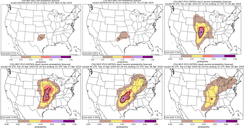
-
April 2024 Observations and Discussion
Black Hole replied to westMJim's topic in East of the Rockies
Your "100+ season" extends into October so hopefully you can keep up the good mood for the next 6 months lol -
PHX torched yesterday and it sure did feel HOT...it hit 102F at 2:04pm...I was at the pool earlier in the day around Noon and it felt like a day in late May or early June. some ppl were complaining but I embraced it and didn't mind the Heat at all. Looking forward to the cool down coming later this week into the weekend.
-
 https://www.msn.com/en-us/news/technology/ar-AA1nstjc Two organisms join to form a new organism. Scientists amazed.
 -

April 2024 Observations and Discussion
chescowxman replied to westMJim's topic in East of the Rockies
It was actually slightly warmer last night with more spots remaining above freezing than Monday AM. The lowest reading I could find was the 29.9 in Warwick Township. Here in East Nantmeal we only made it down to 35.7...I also did not note any frost. While many lower spots have had several days below freezing here in April in EN we have not been below freezing in almost a month (March 25th) Today we should reach the mid 60's for highs. A slight chance of showers tonight and tomorrow with cooler temps again to close out the work week before a nice warming trend kicks in starting Sunday. Chester County records for today: High 91 degrees (1960) / Low 24 at Coatesville (1922) / Rain 2.38" at West Chester (2012) / Snow 2.0" Sadsburyville (1911) -
Putin destabilizes another nation. …Gobble Gobble https://www.newsweek.com/russia-moldova-putin-shor-sandu-1892802
-
How deep into the year can you see snow? Seattle proper has arguably seen flurries as deep into the Spring as May 1st (at night w/o accumulation and probably a precip mix of course), so I imagine May is no issue up there.
-
Had a low of 33 here this morning. So close to a freeze.
-
49F and clear. Nice night.
-

April 2024 Weather in the PNW
Sunriver Snow Zone replied to Tyler Mode's topic in West of the Rockies
00z GFS gives me a foot of snow, ITTTTTSSSS COMIIIINGGG!! (I refuse to look at the kuchera map).thumb.png.db394dec03f2da22c396f13216d7e450.png)
-
I'll send you my summons then
-
5. I’d have to read the book to see if and how much I agreed with it, and if it is being summarized accurately and representatively above.
-
I like a couple sub zeros a year when possible to know i'm alive, also a couple triple digits. Spokane ideal.
-
Pretty nice day. Cool start, then sunshine and somewhat hazy skies with some high clouds at times. 69/38 spread. One more well above average day tomorrow before a cooler and wetter pattern moves in for at least a little while.
-
Agree.
-

West Coast Sports Talk and Other Banter
Front Ranger replied to Anti Marine Layer's topic in West of the Rockies
Nuggets are so fun to watch. Legends. -
 We drove to the Royals Orioles game on Sunday (go O's!). And there was quite few dry areas between here and kc.. much wetter here thankfully. But looks like we all get in on it soon!
 -
Your climate seems like it would be heaven for Jim.


.png.adef18d54aee895f2fa17d13a1f5298a.png)


