
Leaderboard


Popular Content
Showing content with the highest reputation on 02/16/14 in all areas
-
You don't seem to like any forum or discussion environment where you're not the sole source and arbiter of information (see The Weather Space on Facebook), unable to be closely examined and possibly criticized as a charlatan and where people don't grovel in the face of your narcissistic vision of self-grandeur. After all it is 9 parts ego-stroking, 1 part "hey there's a storm coming".3 points
-
no problem, I will say that band offshore of OS looks really impressive and would be nice if it held together as it moves inland, likely a lot of hail, lightning, thunder and definitely some VERY strong winds embedded in that line.2 points
-
Surprisingly getting snowy around my neck of the woods. http://img.photobucket.com/albums/v204/batman7150/cookcreek.jpg http://img.photobucket.com/albums/v204/batman7150/pahump.jpg http://img.photobucket.com/albums/v204/batman7150/blcreek.jpg2 points
-
I see that Tom and if that contain that for a good 5-6 hrs we def be looking at solid warning type snows out of this. It's gonna be a messy commute coming home tom eve.1 point
-
Exactly! I'm hoping mother nature will turn the pattern around next weekend to all snow, all that rain and flooding will really do some damage around here!1 point
-
Cook now under WSW!1 point
-
IBChris, I'm going to call you Dwight from now on. You're brilliant.1 point
-
D**n. That was good.1 point
-
Yeah he said it on facebook. But he's feeling really excited for the thundersnow potential we may be in for a new surprise if this system turns convective. Thinking WSW is all but a given after his strong wording of crippling 2"+/hr totals possible1 point
-
Here's Rap run thru only 22z rather scary, juicy, and snowy!
 1 point
 -
I thought you were in the midst of a 72 hour binge of steady February discontentment. My bad.1 point
-
Uwavingbro?1 point
-
lol! That was a great weekend. Up in the National Forest in SW Washington. My bro in law's bachelor party camping trip. Serious thunderstorms the first night. It was all cloud to cloud lightning as well, so it was an incredible light show. Hiked up to Kalama falls. Just a spectacular view. Lots of alcohol! Great weekend.1 point
-
I am so upset right now.1 point
-
There are other reasons to be upset. Weather isn't one of them.1 point
-
Here's Fort Victoria's journal from January 1847, presumably milder there than further inland. http://www.fortvictoriajournal.ca/1847-january.php I know the Columbia was frozen over at Vancouver for a significant part of January and early February. Of course that was also the winter of the Donner Party down in the Sierras.1 point
-
Tammy model showing general 5-8 inches. Heavy stuff wont make it til 1pm here til 7pm.1 point
-
If this can over perform ORD could crack 70 out of this but not likely it will be close by tommorow night. We just need a a big one and a moderate one by late Feb/March or several more mod winter snows like this to break record.1 point
-
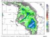
Looking at 3 hour precip totals from the hires NAM, the QPF range from bare minimum to extreme maximum is 0.46" QPF to 1.10" QPF. For example, if a certain color on the map was green, and the precip range for that color was 0.25" to 0.5", the 0.25" would be bare minimum and 0.5" would be extreme maximum, since 0.25" is the least that can be in that shade of green, and 0.5" is the most. Basically, I added up those minimums and maximums for the whole snow event. 5" looking like the floor, ceiling probably around 8" at best. Good range, IMO. Definitely overperformer potential here.1 point
-
I can't get a hold of my mom at the moment. It should be over me soon, keep ya posted.1 point
-
Any thunder, lightning or hail? Looks to be holding together as it moves inland.1 point
-
5 degree temp drop in Westport in 10 minutes with the squall.1 point
-
Marine Warning just issued for coastal waters just south of Ocean Shores Hail, thunder, lightning and wind gusts to 70MPH1 point
-
Oh yea, my mom said this is the worst one for wind in Westport, the whole winter.1 point
-
Doesn't surprise me, a lot of coastal locations are experiencing higher gusts with this storm than yesterdays1 point
-
I was working in Pacific Beach, just north of Ocean Shores around 4 and it had to be sustained 45 or so with gusts over 60 the whole time. And very heavy rain.1 point
-
I think we see MKE/LOT go WSW if the 0z model trends continue.1 point
-
I think the most snowfall amounts are going to be where this system starts going neg and places like IA/WI/IL/N IN are in prime spot for this happening. Folks in SE MI may not get as much bc the system looses its neg tilt as it lifts to the east. There are strong dynamics with this system and the high rez models are picking that up. We are within the 24 hour period and its time we start paying attention to the HRRR/RAP and other high rez models. Global models are good but they won't see the capacity this system may deliver. You can also see the 850's tank as this system goes neg and that will really increase snowfall accumulations tomorrow mid morning/afternoon hours.1 point
-
Must be that massive squall line that didn't come through yesterday1 point
-
Quite the line of intense rain out over the Pacific off the Coast of SW Washington.1 point
-
Hi-res models finally figured out this isn't just going to be a sheared northern wave. I love when trends get better as we get closer to an event.1 point
-
Nice to see the 00z NAM slower and stronger which allows more digging...models getting better sampling and feeding into the ridging out ahead of the system created from the departing Blizzard that hit New England.1 point
-
Interesting. 21z SREF made a huge jump with snow amounts with several members showing 8+ amounts. MKE: 5.22 Mean. Highest: 9.15 Lowest: 0.71 (lol) ORD: 4.39 Mean. Highest: 9.65 Lowest: 1.71 OSH: 5.60 Mean. Highest: 9.46 Lowest: 1.671 point
-
Why can't we let the man have his fun coloring weather maps? He didn't attempt any personal attacks this time, better than what could be said about half of our forum.1 point
-
The office downplaying this may well be the luck we need to get off the schneid of nickels and dimes. You can tell I'm somewhat superstitious.1 point
-
I've lurked on these forums for years. But I got sick of his "God complex" and outlandish forecasts and his refusal to accept the fact that he just doesn't understand how the weather works here. It's why I came on. I'll contribute to weather talk, no doubt about it. Just nothing of interest at the moment.1 point
-
Most systems have over achieved this winter so hoping for this trend to continue1 point
-
It's definitely for the best.1 point
-
One of his first posts was requesting a met tag... I guess he has banned a few people from his "companies" Facebook page over the years because they disagreed with his bullish forecasts. People who are reasonable and active on nw weather Facebook pages. Maybe it is for the best.1 point
-
I'll be leaving the forum , pending a change in where I'm at ... If they are made I'll return. But it was fun, have a good one.1 point
-
Next weekends storm on the Euro is going to have to come north a bit to give Chicago and Iowa snow, right now, it would pass just to our south. This is the Euro snowfall from that event alone. And maybe trend stronger as well.
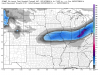 1 point
 -
This system is gonna put me pretty close to 50" for the year. Last I saw for Dubuque was 45.2", but I don't know if that's including yesterday's snow or not. I wish I knew a place that kept that updated.1 point
-
12z Euro...showing a "thump" snow scenario for N IL. Snow may be falling heavily over NE IL for evening commute. Edit: Euro also showing -8C 850's when its starts snow heavily. This may generate very rapid snowfall rates.1 point
-
Congrats Kevin. There were 4 lightning strikes.1 point
-
January 1868 was pretty cold at Fort Vancouver (monthly average of 24), but I believe it was pretty dry cold in Portland/Vancouver (after a near record wet month in December 1867). Eugene and Corvallis had a ton of snow with it, like 2'+.1 point


This leaderboard is set to Vancouver/GMT-07:00