
Leaderboard


Popular Content
Showing content with the highest reputation on 08/20/18 in all areas
-
Omaha Eppley has recorded a whopping 4.45 inches of rain from this system as of 7am this morning... that pretty much wipes out the nearly 3.5 inch rainfall deficit that was there for the year so far. Quite a disparity as usual across the city, as I have around 1.85 inches of rain in my rain gauge in the southwestern part of the city. The heaviest rain band certainly ended up setting up from the Missouri River and then east. Flash Flood Watches still up across the area too, as the wraparound rain continues to fall here, mostly light rain with a few moderate/heavier pockets mixed in... should be able to easily pass 2 inches total for this event in my backyard... would be plenty happy with that! UPDATE: As of the 8am update, the reporting station at Eppley picked up another .99 last hour - up to 5.44 storm total... that's very impressive! Wow!5 points
-
The hits keep on coming. Omaha’s 24 hour rainfall record has been broken today - sitting at 6.83 per the NWS at 12:30pm on social media. Flash Flood Watch extended to 7pm with another 1 to 3 inches possible for Omaha/Council Bluffs. This event is going to make a run at the August 6-7, 1999 storm total record of 10.48 inches. Currently sitting at a little over 9 inches storm total... this is just amazing! What a day here!!!4 points
-
Pouring like crazy outside, lightning and thunder crashing outside for the first time during this whole event... doesn’t seem like it’s going to stop for several more hours now around here. Eppley over 6+ inches of rain with Flash Flood Warnings covering most of the metro. As predicted the low pressure intensified just as it passed to the south and east of here, it’s been putting on quite a show around here this morning with the torrential flooding rains, current thunderstorms, and damaging north winds (up to 60 mph gusts in places). What a storm system this has been for Omaha, this has made up for the recent boring weather and constant misses.4 points
-
A bit smoky out the hospital window on Marquam Hill. Can see the stars though so that's nice. Going in for more surgery early tomorrow morning. Cyborg implant. Several more jerseys on the way!!!4 points
-
Stepped out and tried to take a quick shot. Here is my attempt:
 3 points
 -
Madison getting pounded. Vehicles stranded everywhere many roads closed 5+ inches so far in some areas3 points
-
Haha, unbelievable. It’s been drier than average since friggin’ February in Tim’s backyard and he’s still b*tching. And minus those 2 weeks in April, it’s been downright desert-like, relative to his average. It literally couldn’t get warmer/drier in the warm season if it tried.3 points
-
Incredible totals might be the norm when all is said and done. Here is one for you! PRELIMINARY LOCAL STORM REPORT NATIONAL WEATHER SERVICE OMAHA/VALLEY NE 1139 AM CDT MON AUG 20 2018 ..TIME... ...EVENT... ...CITY LOCATION... ...LAT.LON... ..DATE... ....MAG.... ..COUNTY LOCATION..ST.. ...SOURCE.... ..REMARKS.. 1139 AM HEAVY RAIN 5 E MISSOURI VALLEY 41.56N 95.80W 08/20/2018 M9.86 INCH HARRISON IA TRAINED SPOTTER STORM TOTAL SINCE YESTERDAY. STILL RAINING HARD.3 points
-
Eppley now up to 6.11" at 9am, still raining heavily. This station has reported rain or heavy rain for twelve consecutive hours.3 points
-
Glad to see Omaha has done well. They have been more of a screw zone this Summer than we have so they glad to see them in the defo band alongside us. Light rain still though there is a pocket of heavy rain coming. We have a steady North wind, which is the first time I have been able to say that since May. 65.3*F. Feels like October.3 points
-
Guys, I just checked my notes of the storm systems we had back in November, and this storm matches the LRC to a "T" way back on Nov 11th-12th when a weak system tracked out of CO, and took a due west/east track from KS/MO/IL that had a defo band signature today's system is showcasing. Nature is amazing. #mindblown3 points
-
Good luck man. Pretty brave of you to opt for this new treatment and potentially pave the way for so many others.3 points
-
That's terrific. And now the whole region is way past overdue for some wetter than normal weather and sustained troughing. Been a long stretch.2 points
-
What an awesome wrapped up storm you guys are having in the midwest. I hope we see more of this in the cold season! Today we are traveling thru the mountains of Pennsylvania. Beautiful scenery. Its cloudy and cool. Very fall-like.2 points
-
Sounds like it was a pretty wonky setup that caused that massive model fail, involving among other things a Pacific hurricane invigorating the cutoff energy. The troughing for that period also never quite made it into the range of the currently advertised pattern change.2 points
-
Can't wait for cooler weather2 points
-
Just confirmed on Facebook that the 24 hour record is 6.46”, currently at 6.15” as of the latest update. Have a pretty good feeling that 24-hour rainfall record from ‘99 is getting broken today here in Omaha. Crazy stuff! Even though the heavy rain band is shrinking in coverage, there is still some very heavy rain coming down here as my backyard rain gauge is showing 3+ inches now.2 points
-
I believe the 24 hour record was set in August of 1999 and was 6.46” if the climatology webpage I viewed is correct. That storm was a gusher I remember with over 10 inches of rain over a two day period, most of it falling via intense, severe thunderstorms between 8pm the night before and 7am the following morning, hence the large two day total of 10+ inches of rain. That series of storms caused some pretty nasty flooding in the Omaha area, I remember there being tremendous lightning and thunder going all night long. This storm system won’t be as bad flooding wise as it was spread out over a much longer time frame and wasn’t nearly as intense rainfall rate-wise.2 points
-
6.83" at Eppley as of 10am. Radar suggest at least another inch is on the way. The deformation zone couldn't have been placed any better for Omaha/Council Bluffs. I also just noticed Eppley gusted to 59 mph at 5am. Wow, what a storm.2 points
-
We received more on the Southeast side. About 2.60 inches or so.2 points
-
I was just going to post this. Radar suggests another inch may be on the way, too. The Omaha guys just need this same system to pop up in winter.2 points
-
Raining right now for the first time in 16 days. This after MPX dropped the chances today from 70% down to 40%.2 points
-
Definitely. I enjoyed a nice barbeque (chicken kabob) w wine and salad outside my patio and it was a fantastiko evening. Crystal clear skies and a pleasant breeze. Although, a tad humid.2 points
-
Euro is Almost out to September now. Soggust is almost over
 2 points
 -
Almost 2” exactly from morning rain and this evening’s torrential downpour with possibly more in the next several hours. Unreal. Will this have any correlation to winter precipitation patterns? Should be interesting to see how things play out in the coming months.2 points
-
Just think of it as a nice, cool marine layer.1 point
-
What a beautiful sight this marine push is. Finally liberation from the hellish heat and smoke is within reach. Looking forward to some real precip soon too. Do not want to see any ridging again for a while unless it involves us getting arctic air of some kind.
 1 point
 -
Had a good break from 545 to 730ish... back in it now up to 4.091 point
-
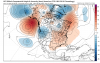
It's better with the Friday trough (which is not a major trough), but does delay the big-time trough for early next week by a day. 12z 18z at same time The big trough drops down at hour 174.
 1 point
 -
I think the biggest issue is he doesn't adjust his interpretations of what is normal for his micro-climate, compared to what's normal for everyone else. Unless it's convenient to one of his narratives. And he also consistently uses inconsistent logic, which is one of my pet peeves.1 point
-
18z goes boxworthy!!! If you lose your mind over individual weather model runs..... you might be a red neck.......... and a weenie.1 point
-
I initially read that as "jerkingoff time."1 point
-
It really is a unique climate - very Mediterranean in the warm season, but very maritime in the cool season. The really rainy reputation really only applies to about half the year (10 months at Tim's location).1 point
-
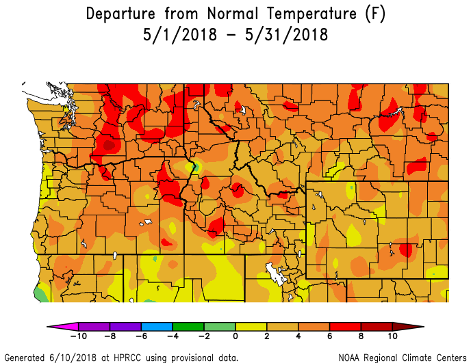
But now even the past 6 months are below normal for your area. Just think how this would look without that crazy wet April!
 1 point
 -
I stopped at "warmer and drier than normal here since late April". That's all that's really needed to be said at this point.1 point
-
Haven't you heard? It's been a completely different word on his side of Rattlesnake Ridge. A completely localized but totally historic washout in February, March, April, and perhaps most infamously in early July. Palmer doesn't reflect that and they are a very dry spot.1 point
-
Upon closer inspection, it's easy to see why Tim felt left out of the warmth in May.
 1 point
 -
Will be lots of continental cold to tap into this time with the anticyclonic upstream wavetrain, where-as the previous fail pattern was more GOA vortex/pseudo-ULL reliant with the cyclonic upstream wavetrain. Opposite of this one.1 point
-
Happy basement flooding to y'all Neb peeps! (j/k) 'grats on the broken record(s) too. Now why can't you (we) get 6 feet of snow when it's cold??1 point
-
This has been in the models for the last several days. Forecasters are gaining more confidence in a major pattern change. Still time of course for things to go bad though.1 point
-
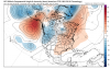
The 12z GFS shows a nice trough digging in over us just before the end of the month. It shows very cold anomalies for this time of year and also brings much needed rain to help put out the wildfires.1 point
-
Man, I’m jealous of you guys. Looks like a beautiful multiweek stretch of troughing is officially in the cards out there. Perfectly timed MJO pass for an early finish to summer west of the Rockies. This pattern is unlikely to change until we’re well into September, given how early we are in this cycle of poleward +U propagation. Gonna get miserable out this way, though. Hopefully it’s not as awful as September 2015. [shudder]1 point
-
Definitely. The -AMO pattern shows up in the EPS mean right through D15 (reverse tripole).1 point
-
Lately, it feels more like Smogust. Hopefully, we can avoid a Smogember.1 point
-
Yeah, the -AMO and Arctic temps correlation has been clear for awhile. Will be very interesting to see how this affects the ice going forward.1 point
-
This after the 29th coolest July on record for the Arctic above 75N since 1850. Hard to argue the -AMO/-AMM isn’t playing a role, perhaps via reduced aggregate poleward fluxes of diabatic/latent heat.1 point
-
The wind is AWESOME! I haven't heard my windows howling since Winter.1 point
-
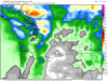
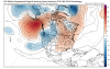
Today's wrapped up storm system is quite the site on radar. I don't think I've ever seen a nice looking defo band as such in late August. Congrats NE/IA peeps who are cashing in on timely rains. This storm reminds me of a few vertically stacked systems we saw in previous LRC cycles that took similar tracks. Meanwhile, Chicago set a record in August...1 point


This leaderboard is set to Vancouver/GMT-07:00