
Leaderboard


Popular Content
Showing content with the highest reputation on 04/06/19 in all areas
-
12z Euro came back S again and nearly covers the entire state of NE with 12”+ of snow along with a raging Blizzard. What a run.4 points
-
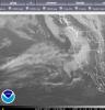
Big storm moving in. It's so dark it looks like just before dawn. Windy, air is so heavy and oppressive. I'm in that hook where it says Benbrook. Fun Saturday, Y'all! Here's the big picture. It's picking up steam as it hits the deep gulf air just east of me.

 4 points
 -
@central neb. and @clintbeed; this disco got me interested wow! Also interesting hearing them talk about previous weather patterns; you can call me crazy but that sounds a lot like the LRC to me. Pattern: a major pattern change is in the offing. The global mdls and ensemble means conts to advertise a longwave trof developing over the Wrn USA. The look over the E Pac will be similar to what occurred in Feb and early Mar...with a high-over-low config between AK and HI. That means odds will favor cooler than normal temps...with a couple days of much colder than normal. Some snow will be possible as well. 1) There will probably be no shwr/tstm activity in the warm sector. This system will advect a significant cap/EML from the Desert SW. All of the precip with this system (at least while it`s over the Plns) will be on the cold side of the warm and cold fronts. 2) Light rain (and more likely drzl) will struggle to form over S-cntrl NEB Wed while a raging blzd will be on-going from the Sandhills back into the NEB panhandle. This area of deformation hvy snow would then move into the CWA Wed night into Thu...with blzd conds probable. This scenario would result in some parts of the CWA measuring svrl inches of snow with significant drifting and severe blowing snow. 3) Sct shwrs/tstms develop Wed eve with steady rain/snow moving in from Wrn NEB and NW KS Wed night into Thu. Most likely any rain would change to snow. Can`t rule out just snow moving in. This too could result in accumulating snow. These are preliminary thoughts and they could be significantly altered. There are probably other scenarios not mentioned.3 points
-
Officially reached 70 here in Cedar Rapids. Feels very nice outside! The last time Cedar Rapids reached 70 was October 9, 2018.3 points
-
Quite a stat from NWS Hastings Twitter: Back-to-back days 70+ degrees in Tri Cities for first time in 6-7 months! Fri-Sat marked the first time Grand Island had CONSECUTIVE days 70+ degrees since Oct. 26-29. At Hastings, it was the first time since Oct. 2-3, and at Kearney it was first time since Sep. 26-27! #NEwx2 points
-
Most years we would be rooting for a big storm, this would not be one of those years.2 points
-
Went to Roscoe,NY today and I saw snow there. (elev. is 1,296'). Temp was in the low 40s., but rebounded slowly. Will try to post some pics. Headed back to NYC later today.2 points
-
Three replies to one post? Someone’s triggered.2 points
-
My car thermometer says 73°. Absolutely beautiful day. I hit the driving range for the first time.2 points
-
We’ve gone past the forecast high as well. Temperature of 77.7 so far today2 points
-
Once the morning clouds cleared, it turned into an awesome day. We've over-performed a bit and reached the low 70s with full sun and a modest breeze. It actually feels warmer outside than inside.2 points
-
2 points
-
How does wildfire smoke from July 1st to September 30th sound? Just enjoy the heavy convective rain while you can. Before you know it, it's gone until October.2 points
-
As promised. Now that I figured this D**n thing out.

 2 points
 -
This was a good one. It blew and rained so hard that nothing showed up in the rain gauge. Plenty of thunder and lightning visible in daylight. Good start to spring. Edit: they're saying we got .80" but I think it may be a bit higher.2 points
-
For this winter, I'd bet on that result vs what it flashed 12 hrs before. Twas a classic punt fake for those of us left out of the main action this #winter.2 points
-
Omg I just want warm weather!2 points
-
Phil is probably the only non-PNWer that posts a lot in the PNW Weather Discussion topics. Looks like they've got a pretty active pattern up there this week. Southern California is a boring place for meteorologists and weather enthusiasts.1 point
-
Still waiting just to "touch" 70F here in the South of the Mitt, let alone up north. Pretty amazing after such a gorgeous day to see not only deep snow OTG but these new snowfall amounts in the last 24 hrs:1 point
-
The 67F we reached around 4 pm beat the forecasted high by a full 4 deg's. With the light winds, it was (to me at least) the first true spring-like day with plentiful sun and no jacket required to be comfortable. We had that one day we briefly spiked to 66F last month, but I was indoors at work and there were some winds iirc. Either way, by the time I headed home in the evening I wasn't hot with my jacket on whereas today I certainly would've been. Took advantage of the light winds this evening to get after my first outside home project scraping and painting the wooden portion of my garage. Mostly the door and it's frame. Been here 10+ yrs now so it's overdue and I've been procrastinating. I like the painting part but all the scraping is a pain especially for a dust-allergic person like me and you can't avoid getting covered with the nasty stuff. Place next door sold and there's been a construction crew for about a week doing quite the make-over. It's giving me some ambition to tackle a home improvement plan I've kicked around for about 5 yrs. Perfect working wx this evening in the upper 50's. Too bad the sun had to set or I'd have been out there another 6 hours.1 point
-
Hillsboro Station (which is more representative of my area than Portland - farther from the Gorge + West Hills) is at 1.25" MTD. That's well above average. On a side note we are also above 10" YTD now.1 point
-
I have a lady in my office who has year-round allergic rhinitis. She clears her throat every 1-2 minutes when it's at its worst. Sometimes she sneezes and clears her throat with absolutely no pause in between. In fact that happens on about 80% of her sneezes. Achooahem. I have never heard any other person do this before. It must be really annoying for her.1 point
-
Now I see the 18z GFS has a 4pm temperature of 75 on April 21st should I wear a light jacket or short sleeve shirt to work that day you think. However for Boston at 5pm the next day I see it is showing a temperature of 63.1 point
-
Storm wind wise busted big time1 point
-
Welcome to the Great Plains and the state of Nebraska in April. Yes; even with all the rain, snow and flooding we have seen we can still see red flag warnings. Other things we will need to watch... Wind: There is potential for high winds (sustained around 40 mph with gusts at or above 58 mph). Fire Wx: If the warmer/more N GFS scenario unfolds...can envision Red Flag Warnings being needed. We will need to check on status of fuels. Severe tstms: can`t be completely ruled out in the further N scenario...but we would still be dealing with a significant cap that could mitigate the risk of svr tstms. Needless to say...there is potential for multiple hazards with this mid-wk storm. Cont to closely monitor fcsts and be prepared to take any necessary precautions.1 point
-
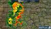
Looking like anywhere from a cutter up through central neb. to a slider over KC. Yah that has some major differences in terms of types of precip on it. Right now if you would say; the Euro is the outlier if you could believe it. Of course things will continue to change but your looking at a major storm with 978-990 mb pressure at its center going off long range guidance. That's something we should see in March or November in terms of snow, not flipping April! EDIT: OAX not buying the Euro but wow if that panned out it would be another historic event to unfold for us in Nebraska. The GFS...and particularly the ECM...are still indicating sufficient cold air advection will move in promote snow accumulations over the CWA. As of now, the ECM is the most bullish with amounts. Still not ready to follow along with this scenario, thus will maintain mention of possible rain/snow mix along/north of I-80 corridor on Thursday night.1 point
-
Got in 27 holes today and man was it fantastic! Tried out new clubs and by the time the round finished I finally figured out the wedge shot! Got an eagle from 70 out and nearly did it again later in the round. Thinking I'll be keeping these babies for the summer! Speaking of; my thermometer on the ram had 78 on it which would be the highest temp since god knows how long!1 point
-
Ended up going with the Embassy because I know what I'm getting there. Happy hour and breakfast ordered is tough to beat! Looking forward to the trip and it might not be worth going to two cubs games with the way they are playing!! Beaching it up for sure so hoping for hot weather that weekend!1 point
-
Feels like an early June day. 55.3*F when I woke up this morning, 78.3*F now.1 point
-
After the low clouds cleared up this afternoon temps spiked into the mid 60’s and feels delightful. Lake breee starting to kick in a bit but it’s still pretty nice out. I can’t wait to feel the low 70’s on Monday which is the Cubs home opener as well. Rough start to their season.1 point
-
Had a high of 72° here. Feeling great! Currently 71° with a dew of 56° & s. wind gusting in the mid 20 mph range.1 point
-
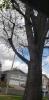
People are trimming some trees right across the street for a few hours now and it is really annoying. Speaking of trees, here is the tree on my front lawn today compared to May 2 one year ago.
 1 point
 -
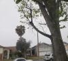
Love seeing this in April.
 1 point
 -
I sure am looking forward to getting thunderstorms again.1 point
-
Picked up .26" this morning, so already .74" on the month. Should be warm for a few days now before a strong system moves in Tues-Thurs. Will likely be a rain to snow event but several inches are possible.1 point
-
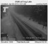
Area of low pressure associated with the system today spinning up right off the WA coast. Looks like a low from a typical December storm very cool looking. A buoy 20 miles west of ilwaco registered a 56mph gust not too long ago.
 1 point
 -
Geez, models, get a clue.1 point
-
What's a few hundred mile shift in 12 hours?? As I said before good look pinning track in transition season..1 point
-
Went from snowstorm to 70 degrees here in Michigan on the GFS. Classic spring. Don’t trust anything more than 5/6 days out.1 point
-
I’m pretty sure the tstorm frequency drops off as you travel north in western Washington. I know the Canadian forum always jokes about the border force field killing thunderstorms during summer convection episodes. Southern Vancouver Island sees even less frequent thunderstorms than The Vancouver area1 point
-
YEP -GFS way north. Would really prolong ice out on lakes- as the snow would insulate the ice from insolation and prevent the ice from breaking up. Got a canoe trip to USA/CAN border here in 5 weeks and this storm would actually help the fishing - if this is the last one-. and the GFS is right.1 point
-
00z GFS a giant leap north, rain up to Duluth and Marquette. Nice consistency, GFS. The FV3 is also north, although not so drastically.1 point
-
We stayed there in May of '14. Somehow got one of their skylight suites with a ton of windows and neat angular design. It was up about 20 or 30 stories too so the view over the river and up to Trump's place was awesome. I liked it. Only downer was catching a very cold weekend of 50s/30s which put a real chill on the normal warm season festive atmosphere along The Mile. Hope your plans work out!1 point
-
GFS has 8-15 inches of snow in Iowa and Illinois. Heaviest falls north of interstate 80. A lot of things will have to come together exactly right for this to happen, if it even does.1 point
-
Ryan Maue tweeted a few maps. You can see the impressive cold feed at 850mb from the southeastern Canada trough.1 point
-
Honestly why I love the Midwest. I enjoy have all four seasons in a week. Keeps things lively.1 point
-
a foot of snow is not. snow mold loves snow cover this time of the year especially after initial melt off. Your yard takes it pretty good. Bent grass of golf courses not so much1 point


This leaderboard is set to Vancouver/GMT-07:00