
Leaderboard


Popular Content
Showing content with the highest reputation on 06/21/19 in all areas
-
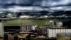
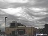
I forgot that yesterday was 13 years since some really weird clouds were spotted over Cedar Rapids. Nobody had ever seen clouds like these before, and there was no name for them at the time. In 2017, they were finally classified was asperitas clouds. These photos led to their worldwide recognition in the world metrological organizations cloud atlas. Photos are from June 20, 2006. I did not take pictures of them at the time, and I really wish I did. https://en.wikipedia.org/wiki/Asperitas_(cloud)
 11 points
 -
You're going to trigger people LOL4 points
-
But I thought we were all going to burn up and die with endless heat and massive droughts and famine and smoke...this summer. What are the fear-mongers going to talk about now?3 points
-
Not much of a storm at all,but at least had some nice looking clouds as it slowly moved in.3 points
-
Omaha has a dome over it this morning.3 points
-
Wow 1-2” of rain here. Seems hard to believe2 points
-
Woke up briefly to the storms this morning. It appears the good stuff stayed south, but now our chances for severe weather have dropped considerably.2 points
-
I haven't been following too close, but I see our rain chances for tonight have decreased. It involves thunderstorms and not just regular rain, so no surprise there. God forbid we actually get some good thunderstorms up here2 points
-
@ IowaWx, today's Severe Wx threat for SE IA may the one that finally provides your strong thunderstorm "fix". Based off everything I've looked at, there is a solid signal for the MCS to track across E IA and more redevelopment overnight and through the weekend.2 points
-
CPC out with their July forecast...2 points
-
Come down to Texas Tom ! 108* heat index today. I'll make enchiladas and margaritas !!2 points
-
Just another October...I mean, June day here in Chicago...one of the more lousy, raw, damp and dreary mornings I've had to experience in late June. This system took the perfect track to hit the lower lakes and to see such a healthy system, comma-shape on radar in the Summer is quite the show from nature. Current conditions at Chicago, Chicago-O'Hare International Airport (KORD) Lat: 41.98°NLon: 87.9°WElev: 666ft. Heavy Rain Fog/Mist 58°F 14°C Humidity 100% Wind Speed N 10 mph Barometer 29.59 in (1001.9 mb) Dewpoint 58°F (14°C) Visibility 3.00 mi Last update 20 Jun 4:51 am CDT Here was the radar loop from yesterday... The last few hours... Widespread 1-3" rains...2 points
-
On June 20, the northernmost town in Alaska, Utqiagvik (formerly known as Barrow), set an all time record high of 73 degrees for June. They were warmer than some California coastal areas socked in June Gloom. However, the heat, at least by Arctic standards, did not last long. An hour later it was back down to 59 and 4 hours after that it was down to 49. This is despite 24 hours a day of sunlight. Tomorrow their high temperature is only supposed to reach 36. So like our early June heat wave, it was short lived.1 point
-
They are the very vocal minority. The rest of us are out enjoying the beautiful late spring and summer weather!1 point
-
The angst in here from the heat misers is hilarious given the month is still running way warmer than average. A few cool weeks and y’all are spinning narratives like there’s no tomorrow. I can’t wait to see the reactions in here when the next round of cool summers arrives in the early 2020s, with that next strong multiyear -ENSO cycle.1 point
-
You do realize this map only goes to July 6th right?1 point
-
should swing through 8/30 at 4:21 and 56 seconds exactly.1 point
-
They had a huge fire in the Strawberries a few years back, but the topography kept it out of the Strawberry and Little Strawberry Lake basins. Here I am casting a line at Little Strawberry Lake.1 point
-
Those clouds would pretty well leave a man awe stricken. That top picture is amazing.1 point
-
To prove that SEA's numbers are 100% legit. Warmest anomalies in the region be damned, other stations in the area are close in temperature.1 point
-
56 and mostly cloudy this morning. I know this weather pattern isn’t everyone’s preferred weather but I’ve been enjoying the last week or so of cooler days and looks to go on the next week or so. Has been somewhat dry here locally but I’ll take this over June 2015.1 point
-
Beautiful pictures. Looks like an awesome place to visit. I'll have to make a road trip down there this summer.1 point
-
As much as I'd like to see some storms, i'm also quite ok with a dry warm day tomorrow. So I'm rooting for that. .78" reported already in Tiffin at Clear Creek HS this morning. Probably will push over an inch.1 point
-
Maybe I’ll just move to Southern California. Sounds like one of the most gloomy and depressing places on earth based on your daily b*tching.1 point
-
Finally, by looking at my extended forecast, Summer weather is imminent. Temps may actually stay in the 80s next week for several days in a row. Wooohhoooooo!!!!!1 point
-
Perfection. Simply perfect. I'll bear this heat out. That PAC is a drawing from my dreams. Historic.1 point
-
As with the 06z run the 12z HRRR has nothing here tonight. I hate it when the first big round of storms of an expected active pattern mostly tracks south. That forces the next round to track south, which forces the next one to track south, etc.1 point
-
Yeah I don’t want to hear it from you CR peeps about always being missed by storms, LOL! Outside of one lousy hail storm that hit a localized area, the severe storm season locally has sucked so far for the most part. Missed to the west, south, north and east - I feel that we are paying for our awesome Winter now. Heard some thunder and had less than a 1/2 inch of rain from this complex - pretty darn disappointing as I was expecting some good storm action here early this morning.1 point
-
Glorious, fantastiko day outside, deep blue skies, not a cloud to be found in the sky, crisp, dry air w temps in the upper 50s, along w a very refreshing NW breeze. Lows tanite will fall in the mid to upper 40s under crystal clear skies. A chilly one indeed. Any outdoor activity today will be approved by Ma Nature. Just, absolutely splendid.1 point
-
We received 2.25” overnight in multiple rounds of storms, 4” just to my west. The last time I can remember a pattern like this was summer 1993. Water standing everywhere with more chances tonight1 point
-
We've had line after line of storms. I took a bunch of mini-naps throughout the night between those waves it seems like. Last wave is moving thru now. 64.6*F.1 point
-
It's a wonderful, crisp, cool and sunny sunrise here in Chicago! My goodness, this is a welcomed sight for sore eyes to see the sun which always brightens up the day with my morning cup of coffee. I like where we are heading over the next 1-2 weeks as Summer weather is finally showing up throughout next week and I better get used to the higher humidity levels. TBH, I really don't mind as I would like to put away my "hoodies" for the time being. Holy smokes, now this is prob the biggest SOI crash of the year! Look for a big cool down Week 2 as we enter the 4th of July holiday period of just thereafter. SOI values for 21 Jun, 2019: Average SOI for last 30 days -8.78 Average SOI for last 90 days -5.20 Daily contribution to SOI calculation -35.291 point
-
Thanks Tom. I think if you go by the actual spring period of March 20th to June 20th you will see KC was right about average. (Maybe) The month of April officially was 1.7 degrees above average, MAY was 1.6 below, and first 20 days of June we were .6 degrees above average. My math may be way off...LOL MCS with thunderstorms on the leading edge heading for KC this morning, we need it as most of the area is 2-3 inches behind for the month.1 point
-
Julian should be in the fog tonight. It's going to be a rather chilly, wet Summer Solstice west of the mountains tomorrow, but it's not the first time such a thing has happened here. Check out June 20, 2003. Here were the highs that day. Even the Inland Empire did not clear out. Great excitement though, as Fullerton was 71 F last Winter Solstice and could have a cooler high than that tomorrow for the Summer Solstice. Remember, CA weather and seasons are not logical.

 1 point
 -
Today, some people had on hoodies and jackets1 point
-
Still raining IMBY, but radar is showing clearing taking ova just to my west. Temps are at a cool 63F w damp conditions. Btw: Being that tomorrow is the first day of Summer, lows tomorrow nite will be in the chilly 40s. What a way to welcome Summer1 point
-
Wow. Cool and wet in the heartland. I'm ok with that.1 point
-
So first two weeks of July likely for heat wave?1 point
-
Dont ya wish it was Winter right now and w cold air in place. Just imagine the beauty outside.1 point
-
If the 00z EPS is correct, we will transition out of this western trough/-PNA wave structure during early July, as intraseasonal tropical forcing leaves the EHEM and emerges over the WPAC/warm pool. In which case, a warmer, ridgier pattern is likely to take hold for the West during the first two weeks of July. So, seems there is still not much of a background state present, should this evolution occur. The subseasonal cycles have dominated to this point. Hopefully this is quick enough to prevent any strong Plains/SE ridge from developing this summer. Need to keep those soils saturated.1 point
-
Where is Summer??? This is a sad stat and an eye opening one...1 point
-
Wow. We have had our windows open the last 2 days. House dropped to 62 degrees this morning and Tuesday it never got above 66 all day in the house. This is the lowest energy bill I have ever had for June. Still have not had to turn on underground sprinklers and after another inch yesterday, back to some standing water on the ends of fields. We might finally get our real first taste of extended warmth and humidity by next week.1 point
-
Probably one of my best photos, exactly 2 years ago today. A strong thunderstorm occurred around the CA border. Later as it got dark I did hear thunder from it, and there was a considerable amount of lightning out of it.1 point
-
Yup, this forthcoming setup is prime for long-lived MCS's to traverse the region. I'm looking forward to witness my first real thunderstorm threat this season. I missed out on all the action while I was out west so hopefully this weekend will deliver. I don't necessarily need the real severe stuff just some strong, electric storms would be nice. As anticipated, SPC has the MW in the Slight Risk for now, prob will end up Enhanced Risk as we get closer.1 point
-
It would certainly be nice to see some real MCS action around here. There hasn't been much of that so far this season. The last couple euro runs have 4+" of rain here over the next week.1 point
-
The 00z Euro is showing some nasty rounds of severe storms across the MW late Friday through the weekend. After flipping through the models, interestingly, the 00z ICON lines up very similar to what the 00z Euro is showing and the MW will be the epicenter of heavy precip.1 point
-
Nice days have been hard to come by here in the Chi, but once the thick fog began to clear up yesterday around 10:00am, blue skies took over and it ended being a top notch day in the upper 70's with comfy DP's and light winds. Driving back from the gym yesterday morning, the skies almost looked exactly what it looks like in San Diego when the fog clears up during the mid morning hours. I swear, if it only smelled like the ocean, it would feel like I was in Cali. It was one of those visual moments I'll remember.1 point
-
Can confirm1 point


This leaderboard is set to Vancouver/GMT-07:00