
Leaderboard


Popular Content
Showing content with the highest reputation on 08/13/19 in all areas
-
Just finished the front yard after several days of neglect. (I may have a problem)7 points
-
Just returned from a whirlwind trip to Yosemite. Left at 4am Saturday and went down the east side of the sierra. Went over Willamette Pass and once on the east side, it was absolutely pouring and temps in the high 40's. I guess we missed some of the TSR action down that way. Weather cleared about 50 miles south into CA but windy and mid 70's. Woke to 31 degrees at our campsite at around 7000' and was in the upper 20's when we hit the summit, just shy of 10k'. Beautiful show of meteors Sunday night, although the moon was annoyingly bright. Something magical though, about seeing the meteors with a moonlit Half Dome and Yosemite Falls. Came home through the Central Valley up I5. Missed all the storms that came through the day before. Mid 90's by the time we hit Redding. Arrived home to a lawn that needs mowing and three days worth of dog poop clean up, but a great way to end my summer travels. Sounds like I missed some weather action, but oh well.4 points
-
Picked up about 1.1” in just over 30 min. Crazy rainfall rates these last few storms within the last week.3 points
-
Beautiful morning here in Lincoln City as well. Fog bank looks to be about 10 miles plus offshore. Got up at 330 am and headed down to the beach with blankets. Just laid back in the sand and enjoyed the moon setting while watching the meteors! A few meteors were intriguing as it looked like you could see the smoke trail and some skipped like a flat rock across the pond! Also saw four burst flashes almost like someone was taking a picture but from space. It was rather strange and need to look that up as I’ve never seen this before. Fascinating stuff just like weather3 points
-
Terrible for TV, cell, and internet coverage, everything is more expensive, and you generally feel cut-off from civilisation. It's really not that great to live there. Stick to visiting, you can take it from someone who lived there and was repeatedly disappointed by missing out on most of the fun weather.2 points
-
I’m heading up to Haida Gwaii this weekend. I’ll send some shoutouts to all who want them. Videos to come.2 points
-
Whether or not we have a warm end of August, I still feel good about October - January 20th.2 points
-
Can't believe someone free solo'd this chunk of rock.2 points
-
Yes, parts of the NATL and NPAC were warmer as well thanks to intensified anticyclones/subsidence. All kinds of chicken/egg/hatchling stuff going on.2 points
-
I think a suppressed but strong SE ridge/Bermuda high generally correlates pretty well with periods of cooler global temperatures.2 points
-
You drove by my exit, Holdrege/Elm Creek MM 257 just west of Kearney. Storms are moving southeast so you should be good.2 points
-
Driving across Nebraska today on I80 west. Almost to North Platte. Looks like we are gonna drive into a thunderstorm. There's a Tornado Watch out over here! We were in Lincoln last night and Omaha Sunday. We're on our way to Los Angeles and then over to Texas and then back up to the midwest!2 points
-
I wanted to share with you some LR thoughts, specifically post Labor Day. Are there any clues on what we may be expecting??? Well, it's about that time of year when I begin paying more and more attention in the N PAC/Western PAC. This year, not surprisingly, I'm beginning to see signs that its going to be an active season of tracking weather systems in this part of the world which will undoubtedly effect our weather pattern going forward. In fact, some very interesting weather is setting up over the next 7 days. With that being said, take a look at the 12z GEFS animation below and one will quickly notice how active the pattern is poised to develop from Japan and points east into the Aleutian Islands/Bearing Sea. If we use the Bearing Sea Rule (BSR), we can extrapolate these systems which will be tracking over this region, and expect storm systems to target our Sub Forum (based on the forecasted track/trajectory) sometime during the 1st week of Sept. I'm looking for what could possibly be an early Frost potential across the north??? Nearly all the operational/ensemble models are suggesting a large storm to spin up south of the Aleutians in about 7-8 days that'll have a big impact to our weather earlier next month. Is summer going to start fading soon...possibly abruptly??? Surely there will be warmer spells out ahead of systems next month which is the usual theme in Autumn. However, I'm fully onboard that strong CF's will be on the agenda so long there are no tropical disturbances in the GOM. I do anticipate seeing tropical systems along the eastern seaboard to track in close so we'll have to see how that plays out. I always seem to enjoy tracking Autumn storms and this year will likely be another active season.2 points
-
WPC has some impressive rain totals over the next week. Hope this verifies.2 points
-
This is our last day of a string of 100*+ days. Currently 91* and rapidly heading for 103*. Good news? 50% chance of rain tonight. Scattered storms. Tomorrow high - a chilly 94*. It will feel like spring after this last week.2 points
-
Did you used to work at Kayak Point? Golfed there decades ago, very nice course. We do have underground irrigation, and yes it is very difficult even with professional maintenance to have every spot in the yard equally watered. And some places need more and some need less, etc. Still I love having it. Just program it and make a few changes throughout the seasons and go. But we do have to blow it out every Fall.1 point
-
Yep. When I would be out syringing greens in the middle of the day, people assumed it was to keep them hydrated. You know a properly constructed green would be just fine with a custom watering schedule as far as hydrating the root zone. I had to explain that the topical water was just to cool the blades via evaporation. I always explain it as a person can be completely hydrated but still get sunburned.1 point
-
Lived in Hebo, some 25 miles south of Tillamook. Everything costs at least a dollar more, we had bush league internet that cut out daily, was lucky to have sat line of sight cuz plenty of folks out there didn’t, no OTA TV, no cell service and 30 min to work anywhere. Why anyone would choose to build their house there is beyond me. This doesn’t even go into the draconian ideologies plenty of the locals have.1 point
-
The 55 at Aurora does seem suspiciously cool...1 point
-
I have a relatively inexpensive McLane 7 blade reel mower that I have rebuilt for about $200 including a new 3.5 horse Briggs engine. The mower sets the pattern pretty well but I always follow up with a weighted roller that really finishes well and also keeps the base level as I mow at 5/8". Requires a lot of watering when it's really hot, but it's only about 500 square feet, so it's not too bad1 point
-
Suspicious. I don't think the 60 degree low this AM had anything to do with it, though.1 point
-
It was cloudy almost the entire time I was there last week.1 point
-
El Capitan in the Yosemite Valley. Taken on Sunday during our visit. 3000' of vertical granite off the valley floor. You can stand at the base and look straight up. Amazing!!1 point
-
It's still 81F past 3pm, yet the beaches 12-14 miles away have been socked in all day by the marine layer stratus clouds. The onshore flow has been really weak the past couple days in Santa Maria.1 point
-
PNW heat events LOVE crushing this sort of hubris. Trust me I’ve invoked their wrath many times before.1 point
-
Matt’s been in a fight picking mood the last few days. Maybe Tim isn’t paying him enough.1 point
-
The storms have sunk south of I-80, so you should be good except for some light rain.1 point
-
Definitely a huge improvement over recent summers.1 point
-
Do you have one of the UHI tracker apps? Free at the App Store, just like the several apps for tracking King County foothill summer cloud cover.1 point
-
Of course. They have seen even more of an uptick in UHI affect the last few years, though, from what I can tell. To me, it’s interesting to track. Is that OK with you? If not, send me a quick PM and I’ll post something about da Ducks instead.1 point
-
Auburn's defense is going to be fantastic and our receivers can't catch the ball.1 point
-
Both the GFS/GGEM are in somewhat agreement that we will see several rounds of storm potential Fri-Sun....nice to get some precip back in the forecast, esp across the D0 drought regions of the MW...1 point
-
DMX had an explanation in their morning AFD on why storms didn’t pan out in Iowa yesterday. Part of the AFD below.... DISCUSSION.../Today through Monday/ Issued at 322 AM CDT Tue Aug 13 2019 Before we go forward, a short review of how things evolved since yesterday morning's discussion. Out of the three scenarios outlined in the discussion issued at 243am on August 12, it seems scenario 1 was the most in line with what occurred. A stronger area of convection developed southeast of the existing thunderstorms coming out of Nebraska yesterday morning. So, southern Iowa had the higher rain totals. Overall, rain amounts in the official forecast were not bad looking at 24 hour MRMS estimates, but were not placed correctly with that caveat mentioned due to the development of the southern storms. The model QPF was well overdone and also not placed properly. The storms did push the warm front/stationary boundary into southern Iowa per objective analysis, though not as far south as the thinking at the time. Reviewing GOES-East visible and Day Cloud Phase Distinction RGB imagery, the cloud shield with the convection moved off to the east in roughly the expected time frame if not a bit faster for western Iowa as outlined in the 604am update. However, the breaks in the clouds were not as numerous in eastern Iowa with plenty of convective cloud debris. The boundary layer did recover with SPC analyzed 2000 J/kg of MLCAPE with deep layer shear marginal. Further, 20z 700mb temperatures were between 10 to 12C over central and southern Iowa and 00z RAOBs from KOAX and KTOP showed a slight cap at 850 and 750mb, respectively. These warm temperatures aloft likely kept things in check over the forecast as far as robust thunderstorm development versus the boundary being too far south.1 point
-
Areas just to my south received nearly 4"+ of water. Very hvy rainfall last night. That line of precipitation was not moving at all. My area got around .50".1 point
-
Finished with 1.05" of rain yesterday. What a surprise that was.1 point
-
We will be in Tukwila Fri-Sat for our daughter's soccer tournament, looks pleasant, mid to upper 70's, maybe some clouds but should still be light out.1 point
-
Is Tim okay? Wow, today was beautiful and he still got triggered.1 point
-
Thanks! Loved it, what a treat! A few years ago I kayaked the Salmon river down below. I wanted to kayak towards the sea but was a bit nervous of the tides. Didn’t want to get sucked out to sea so I kayaked inland. Next time going to kayak west...just looks so inviting Will plan it this time so tide can carry me out then when the tide pushes in begin the journey back. May need to throw a fishing poll in and just chill!1 point
-
.11 herr... bust central after calling for 2+1 point
-
T'stm just popped ova my area outta nowhere. Currently hvy rain and vivid lightning. Under a Flash Flood Warning.1 point
-
I've been drastically wrong in my state and points southeast of me for 2 winter seasons. I'm not self-preserving in the least, in regards to that. When I'm wrong I usually know it by January 1 and try to keep myself off here and from influencing opinion anymore if I miss. I still get sucked into the modeling, like everyone else. I hate that. I want snow. Shoot me. Lol. One handicap I have in my region, (call it excuse or explanation, whichever you choose) is that out of the last 15 winters, I've really only had about 3 to study for the cold side. I have to go backwards to data from the 60s-80s (pre-climactic shift) and sift out what happened. Satellite era is 1979-present so you get where the problem is there. Not excuses, just learning and growing in wisdom here just as we all are. That is what makes it a challenge and a ton of fun. Even if I fail. I want to admit it and do better.1 point
-
Our focus right now, in terms of looking ahead should really be centered on watching the magnificent show of HP building over the next 240 hours in the Arctic and in Canada. The tropical domain and subtropical down here are at their largest in terms of stable heat and heavy wet air. It's just the season. It's still August, no matter how desperately I want for it to be October. Lol. Just watch Alaska/GOA, the Arctic, and far western NAO regions for the next 10. Fixing to watch earth's most beautiful thermo-regulation system kick in to perfection. Canada may not see much above average temperatures for awhile. That's not a wish cast. There are telltale signs also when Alaska records mid-90s+ in July and they did this year. In 40 days, our world down here will be a lot different, I believe. Particularly north of the Kansas border. Going to be a battle for me and Texas, possibly a rough Autumn severe season in the making too. For us (Andie and I), thunder in autumn sounds ahead for winter. I'm excited. Very very, after looking up north today.1 point
-
I can tell you that you're in a winter forum so like you mentioned expect to always see probably somewhat skewed calls for crazy epic winters with things never seen before and predictions such as a new Ice Age coming with the planet going negative starting next year. I wouldn't ever expect a forecast for a dry warm winter anywhere in this forum even down in Texas. I found this forum several years ago before finally creating an account last year I believe and I've never seen a call for a boring winter so it's always take things with a grain of salt I'd say. At the end of the day long term weather forecasts (60-90+ days) are still a crap shoot. Methods are getting better and it's interesting to see some of the techniques being used. I love snowstorms(not so much the cold), and that's why I hang out around here to see what's going on around the region and of course to hope for big storms this winter.1 point
-
Time to celebrate...maybe? Nice little cell about to hit. The first two just grazed to my north and northeast.1 point
-
As we approach the height of the sea ice melt season, I draw my attention up north into the Archipelago region of Canada. Whether you believe we are amidst of a climatic shift or not, I certainly have been intrigued by the resilience of ice cover over the past several years in this part of the world during the summer months. Keeping that in the back of my mind, the northern hemispheric pattern is going to be very favorable for the sea ice to maintain itself throughout the month of August. In fact, it may even begin growing later in August into early Sept. It's going to start getting cold up north (sub 32F) and snows are coming early. IMO, this is part of the reason why I firmly believe the early stages of the "North American Vortex" will brew up once again this cold season. "If you built it, they will come"... Taking a gander at the current state of the sea ice chart below, the Northwest Passage of N Canada are solidly ice covered. Certainly looks like we will have another year where ships will not be able to pass through. Arctic temps have been running just about normal this season.... http://ocean.dmi.dk/arctic/plots/meanTarchive/meanT_2019.png In my own opinion, models are having a devil of a time seeing cold in the longer range. More importantly, they are busting badly on where blocking is setting up. I maintain steadfast that Autumn is coming early and hard up north, farmers across southern Canada should be worried about crop failures as early freezes are in the cards. Similarly speaking, when looking back at the Autumn of '16, southern/western Canada saw very cold air build early and often, esp in October. I do anticipate this cold to build in Sept, not October, a month in advance of norm. Remember last year? We saw a similar tune. Autumn is coming...1 point
-
Yes it was definitely something I'll never forget. There was an 87 mph wind gust at the GI airport before power went out You just don't see this kind of power in non tornadic thunderstorms very often. Mother Nature is amazing.
 1 point
 -
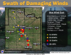
Grand Island just got hit with the best storm I've seen in the 3 years I've lived here. 80 mph winds that prompted the sirens to sound. This went on for a solid 30 minutes and there are trees uprooted all over the city. Power was out for 4 hours. I was awake when it came in around 2:30 AM and I honestly thought we were getting a Tornado when the sirens started going. It looked and sounded like it. I live in an apartment so this was extra nerve racking. I walked around and it looks like the storms I remember as a kid. It's been lame for years here but this one was a classic.1 point
-
There has been lots of talk about a big earthquake in Utah where I live at some point. Apparently up to 7.0-7.5 is possible. I've done my best to get ready but I hope it never comes.1 point


This leaderboard is set to Vancouver/GMT-07:00