
Leaderboard


Popular Content
Showing content with the highest reputation on 09/04/19 in all areas
-
Prayers for Alabama after the lashing they got from Dorian.4 points
-
If the Bahamas get hit again that would be absurdly cruel and unfair. But yeah, I don’t think the US is done by a long shot after Dorian. The season could keep going strong through October given how the system state appears to be trending.3 points
-
This month so far has reminded me of September 2013.3 points
-
This is humbling. We’re so lucky to live where it’s much safer. Grand Bahama island is now 70% underwater. Storm Chaser Goes Silent - Feared Dead. You gotta check this out. https://www.msn.com/en-us/news/world/a-storm-chaser-went-silent-as-dorian-hit-the-bahamas-he-re-emerged-with-a-harrowing-story/ar-AAGM1jQ3 points
-
00z models look pretty favorable for some periodic thunderstorms moving into the valleys from late morning Thursday into Friday morning across western OR and SW WA. LI's forecast to get to -6 in the valley as the upper low swings into a favorable position offshore.2 points
-
Funny story that Bob told me. This happened sometime in the 80's. He and some other relatives own a condo building with a pool. There was a bar across the street and the longest pier in NC. Anyway, a waterspout came ashore and it picked up thousands of empty beer cans that were stored outside of the bar. They completely covered the pool to a depth of about a foot. The bar employees were nice enough to retrieve them.2 points
-
I have an uncle Bob that lives on Long Beach, NC. He's not boarding up, but his house is on 12 foot stilts. He's not too worried. He's been through at least a dozen hurricanes.2 points
-
2007, or 2000 depending on what you mean by "legitimate". For WA/OR/ID in meteorological fall, 2007 was 0.3F below the 20th century average. 2000 was 1.8F below it. They are the only two cooler than average falls the region has seen since 1996.2 points
-
Yep. 2-3" on 1/1, another couple inches on 1/4 with the Arctic front, then about 6" on 1/6 before it changed to freezing rain.2 points
-
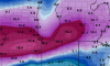
Hurricane Hunter P-3 aircraft took this pic on August 31st, 2019...... Beneath is Dorian's fury. https://s.yimg.com/ny/api/res/1.2/J4QJ_MATXFE1TsQAhupJCw--~A/YXBwaWQ9aGlnaGxhbmRlcjtzbT0xO3c9MTI4MDtoPTk2MA--/https://media.zenfs.com/en/people_218/68b25922e68af43b80994c6a13adaa082 points
-
Something tells me Trump is no weather weenie. Or he forgot he was.2 points
-
Please keep the politics off here. Thank you.2 points
-
This is the first time he ever heard of a category 5 hurricane. Give him a break.2 points
-
https://explore.org/livecams/frying-pan/frying-pan-cam Here we go again ....deja vu
 2 points
 -
The cone had a tumor. Cancer is not funny.2 points
-
Making fun of his boobishness makes you the boob. -Matt2 points
-
Makes sense considering that was only about two years prior to the end of global warming.2 points
-
Plenty of snow fell here in February 2014. We don’t always get screwed after all.2 points
-
May 2013 featured a very impressive 5-6 day in a row stretch of pretty wet thunderstorms in southern OR. I had two afternoons in a row of minor downtown flooding on the 7th and 8th that May. While nothing severe in my area, one of the storms got close. Recorded thunder on the 5th-6th-7th-8th-9th. Third longest stretch of storms I think in this area over decades of t'storm activity. A few of the underpasses had water high enough a vehicle would just get stuck in. At KLMT 2013 was supposedly the driest overall year but clearly the airport here missed the bulk of some of the storm events. I can pull up quite a few examples of spotters reporting 1+ inch in an hour, and there might only be a tenth of that at KLMT.2 points
-
May 2013 also had a pretty decent rain event. Other than that, a very dry year that got drier the farther south you went. It was the year responsible for kickstarting the CA drought and was the driest year on record at many CA locations if I’m not mistaken.2 points
-
Latest gfs run looking wetter over the next week.
 2 points
 -
I'm going to Florida again in November. We'll see if it really hooks me this time.2 points
-
GFS has a terrible sense of humor.2 points
-
T'storms occurring in northern CA, been seeing flashing last 30 minutes or so to the south of the border. Radar trends favor me getting some action in town sometime before midnight.1 point
-
66F and clear. Good star watching night. Jupiter still super bright.1 point
-
I always figured that the Old Farmers Almanac’s claim of 80% forecast accuracy is totally far fetched. On September 4 Terry Swailes posted on his blog the results of Steve Gottschalk’s observation of how accurate or inaccurate they were last winter. On most months last winter our area was opposite of the Almanac’s forecast! I expect you Iowa posters already saw that, but thought I’d mention it anyway. As far as woolly worms go, what I’ve seen so far were light colored or a yellowish white. I’m not sure what that foretells as I’m not much into weather folklore. I remember last fall I saw a lot that looked exactly like the one pictured on Terry’s post. There are a lot of crickets, or more than usual right now, and I’m often running into those many nasty spider webs lately, but that’s normal this time of the year. https://www.tswails.com/home/Date/2019-091 point
-
Did Tacoma get snow in Jan 2004? That was one of the better snowstorms in these last 15 years in the PDX Metro.1 point
-
Cousin getting a bit nervous now regarding his rental on the Outer Banks. Luckily it’s just that and not his primary home. At this point he’s expecting just minor damage. Watching with great interest Live cam link he gave to monitor this area....https://m.youtube.com/watch?v=0JUaF0CY7Co1 point
-
February 6-8 14 was pretty fun up here. Three snowstorms on 3 consecutive days doesn't happen often.1 point
-
13-14 with larger deformation precip shield. 08-09 was torturous down this way.1 point
-
Yeah, give me 08-09 over 13-14 any day of the week. I will always sacrifice some cold air for more moisture.1 point
-
Sea surface temperatures were just about average where Dorian was the worst, so we can't really blame this one on climate change.1 point
-
True...although most on here would take 1 big snowstorm over two dry Arctic blasts.1 point
-
Wilmington area again...ouch1 point
-
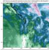
https://cdn.star.nesdis.noaa.gov//GOES16/ABI/SECTOR/TAW/GEOCOLOR/GOES16-TAW-GEOCOLOR-900x540.gif https://cdn.star.nesdis.noaa.gov//GOES16/ABI/SECTOR/EUS/GEOCOLOR/GOES16-EUS-GEOCOLOR-1000x1000.gif Takes a moment to load but cool animated shots Just fascinated how Dorian is following the contour of the East coast! Currently 73*1 point
-
Ryan Maue, the voice of reason in this, had a good thread about it. I did not know the NHC has a 7 day cone that they do not show the public. Ryan MaueVerified account @RyanMaue 4h4 hours ago More Insane people: Extrapolating the NHC 5-day cone of Hurricane #Dorian is most definitely an impeachable offense. Normal people: yeah that's probably a reasonable extrapolation into Day 7. Ryan MaueVerified account @RyanMaue 4h4 hours ago More The NHC creates an internal 7-day forecast -- not for public consumption -- but will in future years. The huge 7-day cone would definitely be over Alabama for Hurricane #Dorian even though there was ~0% chance of a direct landfall. This will lead to further confusion. Ryan MaueVerified account @RyanMaue 3h3 hours ago More Maybe it's a good thing we don't issue 7-day forecasts yet. Had I advised the President on Wednesday evening, I'd probably have told him that #Dorian could cross the peninsula into the Gulf and end up in Alabama, sort of like the WPC 7-day surface prog. Ryan MaueVerified account @RyanMaue 2h2 hours ago More Thankfully, the acting NOAA admin Neil Jacobs was asked to personally brief the President with trusted, accurate information. The threat to Alabama quickly went to zero as new model data arrived. But, Trump's Tweet didn't reflect that new info. Ryan MaueVerified account @RyanMaue 2h2 hours ago More In summary, the "Alabama" Tweet was based upon stale information. The motivation was obviously to inform the public & update on Dorian. Nothing nefarious. Just admit it an move on, right? Nope. That's not how this works between media and Trump. More 31 replies 42 retweets 1301 point
-
Heard that people in Louisiana are bracing for impact.1 point
-
I’m sorry summer got off to such a late start. We’ve never seen a late summer make landfall before. Unprecedented.1 point
-
UHI. Low solar.1 point
-
13-14 repeat would be great. S valley got the nice early Dec event with 5-7" of snow around Eugene/Springfield and temps getting to -10F tying the all-time record low. Then the great early Feb instance with a cross-cascade mountain wave event and lots of snow. Was a Willamette Valley Special for sure.1 point
-
Fo shizzle!1 point
-
That December was crazy dry. A record up here with just 1.23” of precip.1 point
-
That was an interesting month. Had 5.95” of rainfall here, and we also hit 90 degrees 9/11 which is rare for Tacoma that late in the year. In 2013, September was also the wettest month of the year.1 point
-
That is why I will neva build or buy a home down south.1 point
-
Yeah I was just reading DMX and they said it should be short lived as another cold front is expected mid next week. We're kind of on a roller coaster right now.1 point
-
Played in a four man scramble on Sunday as a part of an all lefty group. Too many people were giving us a hard time. We won with a 57 gross. Buddy notched a hole in one on a 178yd par 3 to put the nail in the coffin.1 point
-
Looks like a severe t-storm warning went up today up around yale BC.1 point
-
Cold ocean water creates gloomy marine layers and drizzle. Warm ocean water creates deadly hurricanes and heavy rain.1 point


This leaderboard is set to Vancouver/GMT-07:00