
Leaderboard


Popular Content
Showing content with the highest reputation on 11/02/19 in all areas
-
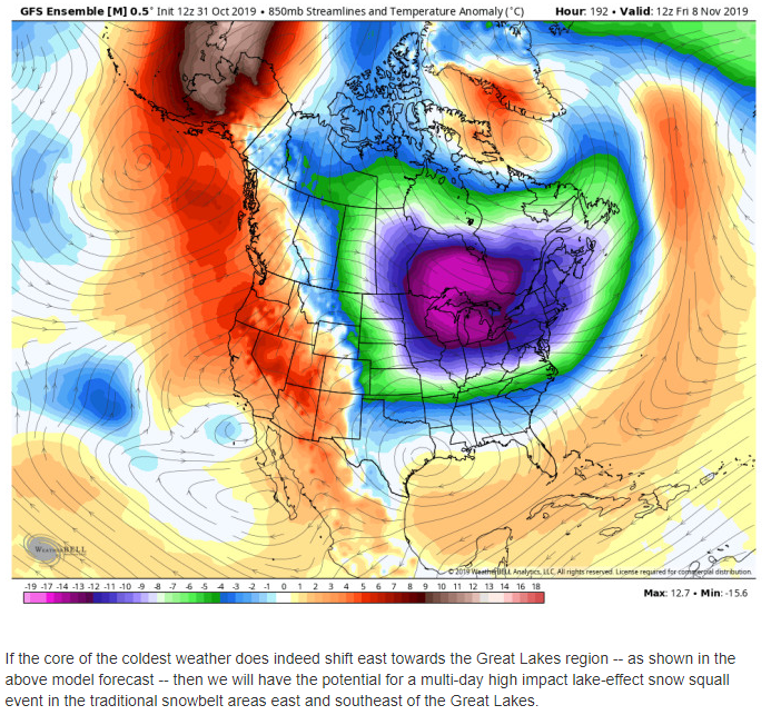
Man the gfs is bouncing that storm all over. But really intense near the great lakes.5 points
-
Policy change at ECMWF now allows imagery (model run charts etc) and data (tables etc) to be shared publicly similar to the GFS and CMC/GEM. It’s a long overdue change and a welcome one.4 points
-
The saddest day will be when Phil loses touch with his memories of living at high altitudes.4 points
-
The system that Clinton has been talking about on the 7th/8th has everything to do with the trough that has been spinning just west off the coast of CA. The timing of when this energy ejects out into the plains while the northern jet drives south into the heartland will be the determining factor if we end up with a potential storm system to track. My gut says the Euro has the right idea and has been slowly trending this energy to eject out quick enough and allow the time for a formidable system to develop. With that being said, it's laying down a swath of accumulating snow from N MO/IL/IN/MI/OH. Hopefully this trend will continue. I'd like to dive in farther into this pattern and what will be another big clue for the winter pattern and this trough that has formed off the SW coast of the U.S. is an indicator of the STJ ramping up. In the heart of winter, this is where you want storm systems or energy coming off the E PAC to track and ultimately phase with the northern stream. IMO, this is an interesting feature of this pattern that has not happened yet since the start of the LRC. As the jet continues to strengthen, we might see more of this down the road bc I have no doubt in my mind the NE PAC ridge is going to flex its muscles and this region may very well end up being a hot spot or the area where the Aleutian Low "hands off" energy into the SW U.S.4 points
-
Our obsession with analogs is sure gonna make all of our geriatric spirals into dementia quite interesting...3 points
-
I just wanted to add that I also hope DJ Droppin is correct with regard to his speculations.3 points
-
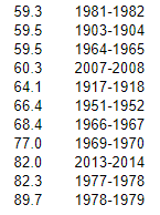
I've been gone a few days... Well here's October 2019 in Klamath Falls.. High: 59.5 (-3.4) Low: 25.7 (-5.3) Mean: 42.6 (-3.3) Second month in a row to end moderately to considerably below normal. September 2019 had a mean of -2.0. I could be wrong but haven't had a cool stretch of months like this in some time? There have been lots of months in the range between normal, to slightly above, to considerably above in recent times. I would like more moisture however, please rain a tiny bit this November.3 points
-
oh it will it always does.3 points
-
Truly an incredibly beautiful pattern. Wow.
 3 points
 -
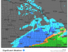
GFS wants to sink some ships on L Superior. When was the last time any model showed a 959mb in the upper Midwest?3 points
-
Halloween was the coldest day since March.
 3 points
 -
Sun spot cycle 25 looks to have begun. At this time there is one sun spot on the sun the magnetic polarity of this sunspot has reversed. This is a indication of new Solar Cycle 25 has begun. https://spaceweather.com/3 points
-
CMC putting together a much stronger and colder Thursday system.3 points
-
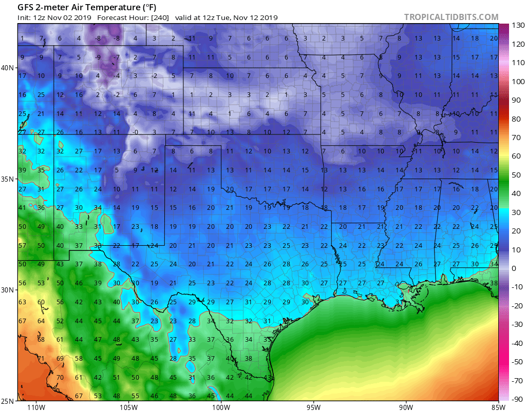
This would be the coldest November day in a long time. In fact, it would shatter records, I think.
 3 points
 -
What a pattern being depicted today. An 11-11-1911 run right there. Wow.3 points
-
It actually drops the low from 1002 to 959 in the matter of 36 hours https://www.tropicaltidbits.com/analysis/models/?model=gfs®ion=us&pkg=mslp_pcpn_frzn&runtime=2019110212&fh=2523 points
-
@ Tom From that link Niko posted, Chicago's top (11) snowy winters include so many analogs to this coming season, how can you not be giddy at the potential?? (so crazy that the top 2 were back-to-back). Got odds on breaking into that list??
 3 points
 -
GRR has a "kitchen sink" day for wx here: Occasional Showers, Some Downpours with Small Hail or Snow Pellets and Perhaps a Lightning Strike3 points
-
00z GEFS have been trending better in the precip anomalies and showing its bias correction again....as I type this, I just heard my first Christmas season song in the background....#holidayseason is around the corner...3 points
-
Im up 600.00.....so far.3 points
-
California had some surprise rain and hail and even lightning this morning from a misbehaving cutoff low just off the coast that proved to be a weatherman's woe. It was all very isolated, however, but it did bring some pretty clouds.2 points
-
A November 1985 analog dropped out of the sky and landed right next to my dog the moment I took this pic. Prepare now!
 2 points
 -
There have been some pretty good PNW winters recently. But no one nailed them, timing-wise. Which is a fairly impossible ask of LR forecasting.2 points
-
The thing is, seasonal analogs cannot always be predictive of tendencies on weekly (or even monthly) timescales, especially during seasonal transitions. And the farther back you go, the more likely it is that you will not have analogous large scale boundary conditions to work with, irrespective of ENSO or what have you. Furthermore, years with completely different ENSOs, etc can produce very similar outcomes both seasonally and subseasonally at particular locations. So the signal vs noise (background state vs intraseasonal variability) issue comes into play. The most surefire way to obtain predictability via analogs is to aggregate the largest sample size possible, with the greatest degree of homogeneity to the current system state from a lower frequency standpoint. The higher frequency variability can arise out of the lower frequency state, or sometimes vice versa, but it can’t be predicted accurately until the former (low-freq) progression is nailed down.2 points
-
You just reminded me of a Saturday my dad and I had to drive to the plant and install new veins in a water circulation pump or the pipes would freeze and break. It was 5* at like 3 in the afternoon. Darn cold winter.2 points
-
Lol!!! Jesse will encourage wet depends while Tim prefers dry. No want to imagine Phil’s !2 points
-
Our generation will be the first to enter the senile stage of life being so connected online...going to be some interesting posts on social media and this forum some day from the nursing home! Fred Jr will really have his hands full!2 points
-
The 70 year climate oscillation cycle!2 points
-
1949..forever and always the top analog.2 points
-
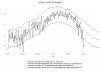
We are going to pay dearly for the doldrums we're in right now. 00z GFS in 4 hours 3 minutes2 points
-
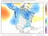
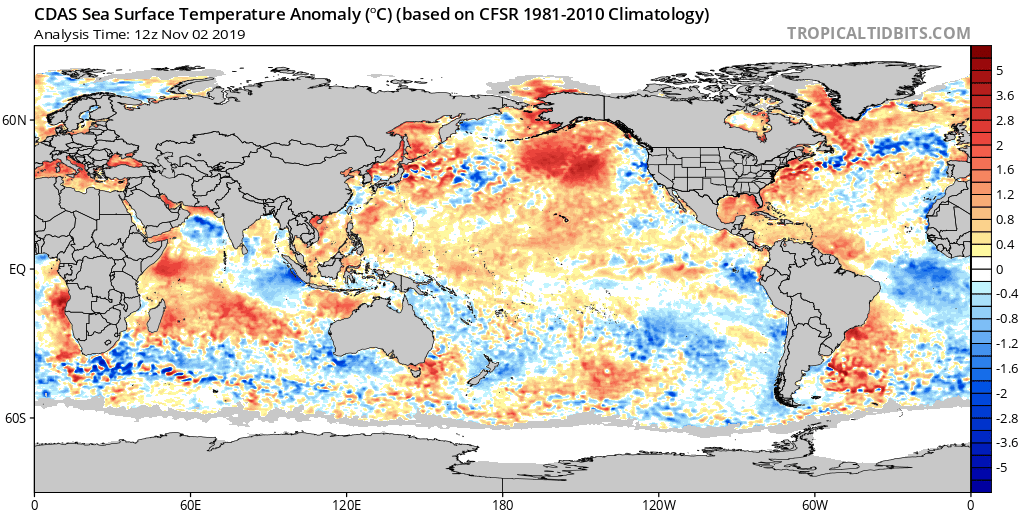
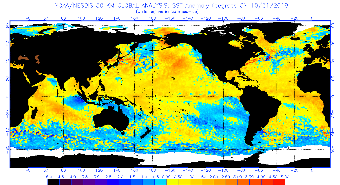
SST update as we open November....
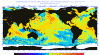 2 points
 -
I like the way that solid snow is right in mby. Awesome!2 points
-
If the 3 week rules apply over the BSR, it won't relax. I haven't saw any indicators it would relax at all, which goes against even my own assessment that it would relax. Add in a stratwarming event plus a CP Niño developing, cool waters off Baja, warm NE PAC, a tendency to go -NAO, and you're basically writing out the winter. Will be interesting to watch the pattern over the next 5 days. Especially the Bering Sea low area to see how long that persists. These cold waves have been coming one-after-another since the first week of October.2 points
-
It was cloudy and cold at my grandma’s house (she’s dead). Two days later there was eight inches of snow (Rod Hill). Two days later the church by my house burned down during an ice storm (haha Jesus).2 points
-
My 9yr old self prepared to eat turkey and walk on a frozen Lake Goodwin while my parents were sidetracked with said turkey.2 points
-
Nice 3” swath from MSP to near Money too. I’d take it.2 points
-
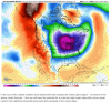
This is, in part, a response to the activation of the MJO (or its emergence over the dominating IOD signal which has been inhibiting its regular emergence out of the IO). It crosses the Maritime Continent over the next 10 days producing a trade wind burst, then propagates out over the warm pool/dateline, at which point constructive interference with the background state resumes, culminating in what should be two WWBs, the second one being displaced eastward. The CFS doesn’t represent this very well, but here’s the 850mb projection.2 points
-
And mid-November is the most “zonal” subseasonal period, with a +EAMT and modest jet extension (which might not even reach the PNW, or barely so). Could be the GFS rushing the progression, but if you want big cold, just wait until the rubber band snaps back with the flip to -EAMT, AAM is removed from the atmosphere, and the East Asian jet retracts. Gonna be a wavebreaking party in late November. No semi-permanent Baffin vortex in sight right now..the next two weeks are the closest we’ll get to that for awhile, and it’s still very displaced.2 points
-
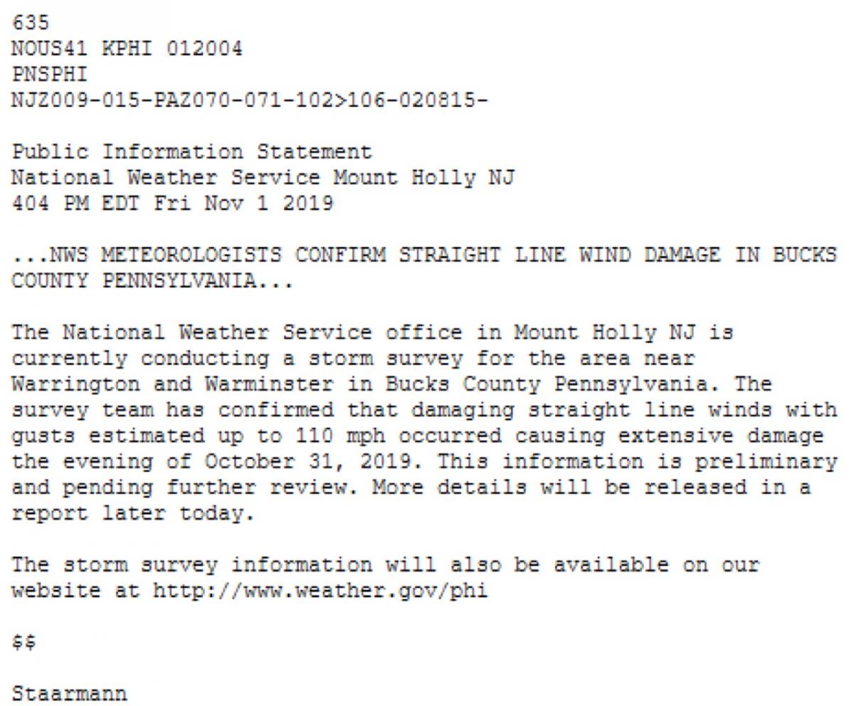
Estimated at 110mph, actually. Scary stuff.2 points
-
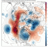
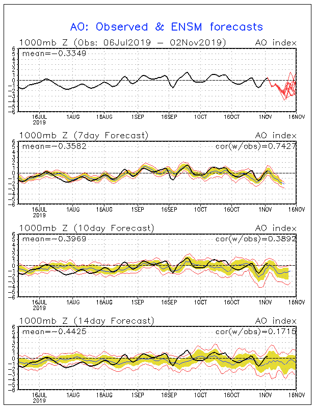
Big time AO crash trying to take shape.
 2 points
 -
Thanks for reminding me of that one. It may show up on the others.2 points
-
I know this is way east, but in response to the map and Okwx's comment get this.....100mph winds in Bucks County, Penn.!
 2 points
 -
2 points
-
It's a thing of beauty 1054hp in Montana. Wish it was a little closer.2 points
-
Yeah, Euro brings my first legit snow chance Thursday..hmm
 2 points
 -
May not be as extreme as Nov 2014, but we could be looking at a legit LES event. If your place is far enough away from the lakeshore you could score bigly.
 2 points
 -
Yes, there is definitely a pattern developing right across the heartland where storms energize and then eventually peak in intensity across the OHV/GL's. This is one of the more definitive storm tracks I've seen ever since I've been following the LRC. A lot of times in years past, the storm track would favor one part of the Sub or the other. This year, it does raise some eye brows as to where the pattern is heading.2 points
-
Now there is something ya don't see quite often in November.... Hazardous Weather Outlook Hazardous Weather OutlookNational Weather Service Detroit/Pontiac MI743 AM EDT Sat Nov 2 2019MIZ047>049-053>055-060>063-068>070-075-076-082-083-030845-Midland-Bay-Huron-Saginaw-Tuscola-Sanilac-Shiawassee-Genesee-Lapeer-St. Clair-Livingston-Oakland-Macomb-Washtenaw-Wayne-Lenawee-Monroe-743 AM EDT Sat Nov 2 2019This hazardous weather outlook is for southeast Michigan..DAY ONE...Today and TonightAn isolated thunderstorm is possible during the afternoon. Pea sizehail or ice pellets are possible with the strongest activity whilemoving west to east at 30 mph.2 points
-
2 points
-
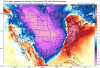
Think Cold and SNOW!!!! 6z GFS in 2 hours 17 minutes2 points


This leaderboard is set to Vancouver/GMT-07:00