
Leaderboard


Popular Content
Showing content with the highest reputation on 02/25/20 in all areas
-
Not only a solid snow event, but one falling primarily during the day? I'm down.6 points
-
For the second day in a row there is a snow squall warning in Kansas, this time in the Goodland vicinity. There is also a special weather statement for a strong snow squall northeast of the Wichita area. I can't recall this ever happening before unless it was back in the 1960s or 1970s (when I was a kid). This could have been a monster storm if all the pieces had come together correctly. There is heavy snow falling to my southwest - normally a good sign of things to come - but I likely won't see a flake. Crazy...5 points
-
I think we can put to rest the line of thinking that goes, "Oooh, look, a warm blob in the northeast Pacific! Winter in the east is going to be awesome!"5 points
-
Twitter reports of 6-10" from Johnson Lake to Cozad Nebraska both in Dawson County.4 points
-
3 points
-
Just like that, heavy snow has moved in. Visibility at 1/2 and dropping. Winds gusting to 35 MPH. How long will it last is the question.3 points
-
Haha, was such a busy Monday I couldn't follow after my early morning post(s). First bolded portion is why GRR hates synoptic systems and their challenges. While not a science focused AFD, they at least did a decent write-up overnight wrt models/trends/scenario3 points
-
About an inch on grass and colder surfaces...pavement is to warm and wet. The warmth from the past couple days really did a number on the frozen ground. I just can’t help but think what this storm “could” have been when they were flashing those big totals. The wind is howling and blowing the snow sideways. Yet again, we have a storm with marginal temps and warm ground.2 points
-
Missed some of these amounts by 1 county to my south, southwest, and west. Of course. https://twitter.com/NWSHastings/status/1232401882112495621?s=202 points
-
Well our snow stopped about 1:30. Probably got close to 2" but lots of blowing and some melting it would be a little less imo. I guess this is the winter we're having and nothing we can do about it.2 points
-
It's really going to take off once the energy phases. It's a shame that rarely happens around here.2 points
-
This march looks like worst case for me. Warm start to ruin my ski hill, then cool off so I can't go out on the lake. EDIT: Also, this winter doesn't seem like it was that bad looking at snowfall totals. It just felt really bad because December was a big fat nothing and we got ahead in average so fast because of the Halloween storm. I think this winter is a good lesson in trusting models too much. An early snow is almost always a bad sign for winter being snowy and cold. And this one would have ended up below average if it weren't for the early one giving the stats a big boost. In my gut I knew we were in trouble when we got an early snow, but the models kept teasing us.
 2 points
 -
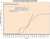
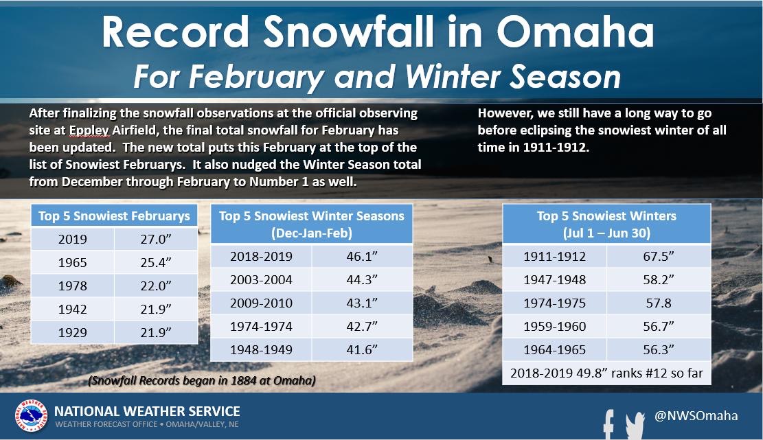
What a difference a year makes. 27” of snow last year in February. Not even 1” (.8”) this year.
 2 points
 -
2 points
-
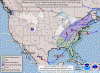
While falling thru the cracks of WPC's d3-7 hazards map, I did actually get on NOAA's day-2 for Hvy Snow fwiw..
 2 points
 -
The only chance I have at maybe 1-2", I'd guess less, is from another snow band north of Grand Island moving to the Southwest. Always interesting when you see precipitation moving northeast to southwest or east to west.2 points
-
Very very foggy out. That usually precedes a big storm, so I'm starting to get excited. 35°F, rain supposed to start this afternoon with a changeover tonight.2 points
-
bring on spring already!!!2 points
-
Bust here. Not 1 flake. The snow band set up 15 miles south, west, and northwest and sat for the night. It continued to move west southwest. NWS Hastings started trimming away counties on the east side of WWA and I'm sure more are coming. Been a rough winter for forecasters around here, and I know other places in the forum. Many schools have late starts or are closed just to my west. There have been unconfirmed reports of 6-10" in this band. This is the band that was predicted to sit over my county. Well, what can you do. Weather will do what it's gonna do. Frustrated. This is why I wasn't banking on this last night.2 points
-
CLE suddenly cares about this, as evidenced by the watch2 points
-
Not sure why but my office has issued a wwa for up to 2 in of snow, I think I'll be hard pressed to get a dusting.2 points
-
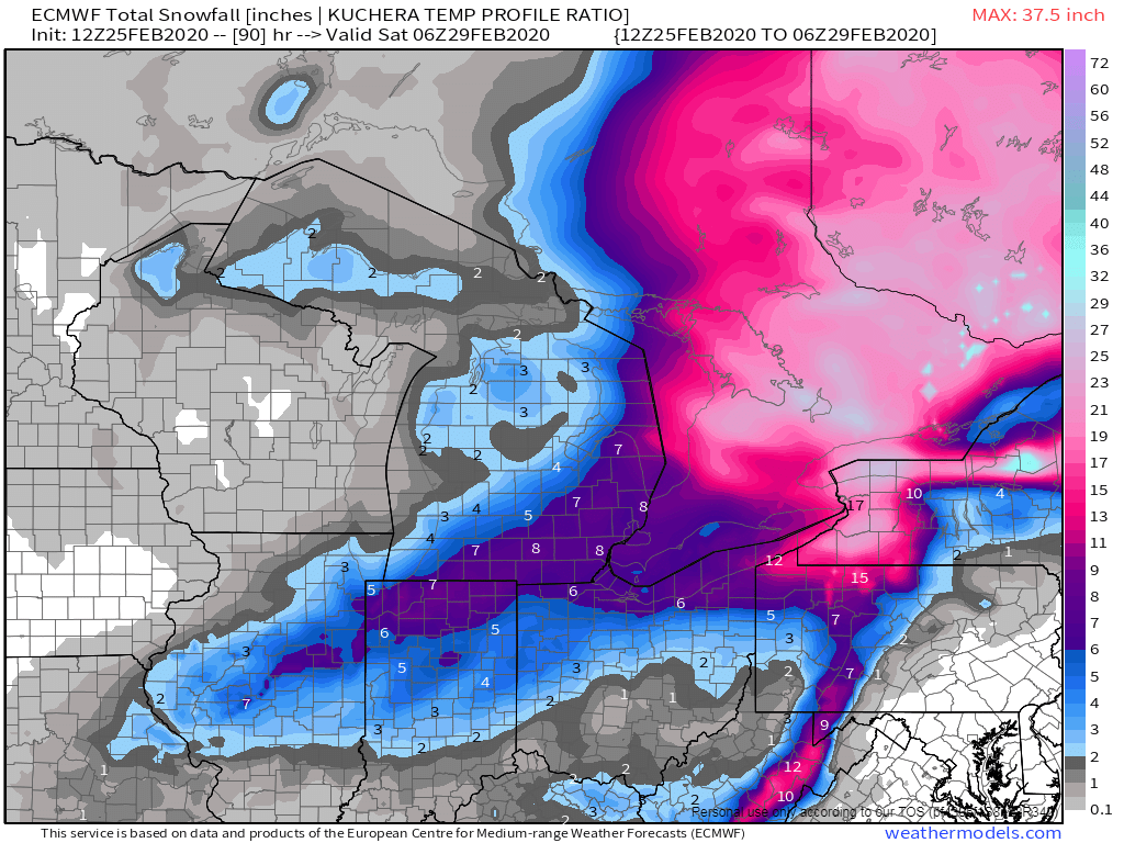
Thank you for the maps, Tom. 06z RGEM also supportive of 6-8" here. Thinking that's where it will land with an outside shot at some double digit totals. Unless the Ukie is right...2 points
-
00z Euro...@ Hoosier/Niko/Toledo, looks like this one is heading your way! Another stat padder, if that, heading for ORD.
 2 points
 -
Unfortunately "next" is about 8-9 months from now. The biggest snow of the winter in Lincoln was 1.8". Just terrible.2 points
-
Been coaching 7th grade basketball this afternoon and evening so have been out of the loop. NWS Hastings has a snow band setting up over my area of Central Nebraska and not moving much. They mention a general 2-4” but possibly a much heavier band that could drop warning criteria snows of 6-8” with winds gusting to 40 mph. All I heard after our games was “what are the chances for a snow day tomorrow”. This would be quite a storm it it materializes. Not assuming anything, but hoping for the best.2 points
-
what an epic collapse!2 points
-
Glad you enjoyed the time up north. Sounds like a blast! Pretty crazy to think that winter fishing season is quickly coming to an end. I got out on our lake exactly one time all winter. Pretty soon we’ll be talking about ice out dates. This winter has been enjoyable like you said. Not too cold, and a good amount of snow. But I’m looking forward to spring after this past weekend. Thoughts of rolling the dock into the water and planting the garden.....ahhh! But, there’s another decent snow storm or two to deal with first. As long as we don’t get 30” in April like we did 2 years ago. Not sure I’m interested in that again so soon.2 points
-
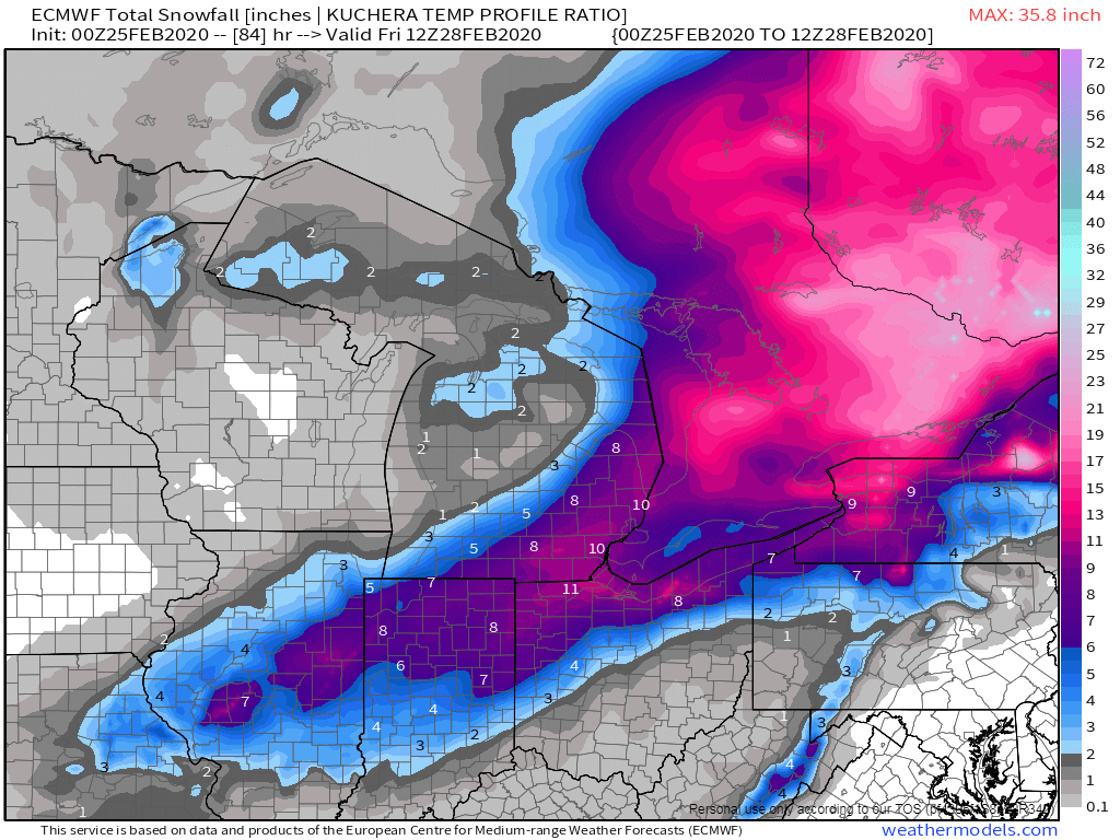
Riding the NW edge of the solid 0.5" qpf shield, and thus GRR's 4-6" map cutting thru here looks pretty accurate. I expect to lose a lot on warm ground, but elevated surf's and remnant snow cover should stack ok.
 1 point
 -
Interestingly though the AFD reads 6-8" attainable in eastern counties and our zone forecast explicitly totals 5-8". Regardless, let's hope for some enhanced banding (3km NAM style) to get us to those higher totals.1 point
-
GFS and other long range data showing winter is ending quite abruptly. Lot of spring like days showing up. Winter was okay here in KC, would have been a wild winter had temps been much colder. We had way more rain storms this year compared to last year as last winter was much colder. We had the storms this winter, just couldn’t get the thermals to match up. JAN. by far was the best winter month here, ice and snow totaling 5-8 inches around town. Only had one winter event in DEC. and FEB. officially we had 15.4 inches of snow during the winter season. 1.9 fell during the fall months. So, if we don’t see any more snow, KC will finish below average on snow and way above on temps. We had a wet winter here so spring should start with a bang. Looking forward to spring and baseball!!1 point
-
Shoulda expected the models to dry this thing up a bit. Now looks like the highest totals will be a mid-range WWA.1 point
-
Pretty LOL worthy the way my office is so inconsistent with the "Watch" headline. With just 3-6" amounts in the actual wording, it's baffling how they considered this worthy, while Jan 17-18 delivered a solid 6" of concrete (with models showing 8-10+) in short order, yet that was automatically a WWA1 point
-
Hate when my office is right, lol. Their early call y'day of "this looks like a 3-6" event" (while maps were showing 10+) seems likely to be reality. Weak/SE trend of the season for most of our Sub continues. Congrats on being one of the few Peeps still in the game.1 point
-
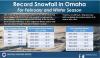
Picked up another 3" yesterday and early this morning. Up to 41" of snowfall on the month now. Ski resort in town reporting 16" of snowfall in just the past 24 hours as well. February has been very good to us in what is normally our driest month of the year.1 point
-
00z UK - If this continues, the storm won't phase until it's out of the country.1 point
-
Local mets have me back in the 40s next week, which will be first week of March. Definite spring vibes.1 point
-
I haven't seen this in Kansas for awhile...DDC has issued a snow squall warning for parts of their CWA...here is some of the text... * Until 700 PM CST.* At 601 PM CST, dangerous snow squalls extended from near Dightonto near Garden City to near Ulysses to Liberal, expandingsoutheast at 30 mph.HAZARD...Poor visibility in heavy snow and blowing snow. Windgusts as high as 50 mph.SOURCE...Radar indicated.IMPACT...Dangerous life-threatening travel.Be aware of very rapidly changing visibility in heavy snowshowers.1 point
-
CLE couldn't possibly care less. The contrast between them and neighboring DTX is actually weird considering they usually coordinate pretty well. The difference in the lengths of their AFDs shows it. CLE I love how obvious it is too that they didn't wait for Euro before writing it. DTX1 point
-
By the way, congrats to you peeps in N IL and S MI. At least I hope you folks are able to cash in from this storm!1 point
-
If it wasn't for last minute Southeast shifts, I'd be in play for record low snowfall.1 point
-
UKIE won this battle in terms of placement of the snow shield but amounts were lower than what they will prob end up being. Boy, the forecasters must be so frustrated with the modeling this season. If one would have read the LOT discussion this morning, you'd be banking on a major snowstorm for N IL. Crazy how many shifts we have seen inside 24-48 hours.1 point
-
Whoa, sorry about that. Happened here many times over the years as well. I know how frustrated many on here must be.1 point
-
If the trends continue, you may see some headlines in Central Nebraska. With 40 MPH winds, could we some "blizzard conditions"? One can dream.1 point
-
Time to think spring, boyz...
 1 point
 -
Good luck everyone south and east! Hope you score!1 point
-
Every model run has seen it's fair share of shifts so I would expect it to continue until start time. This time tomorrow we should know which model will end up being the winner.1 point
-
12z NAM and 3K NAM with huge shifts southeast again compared to 00z and 06z. At this rate, we will be lucky to get a single flake. This was the type of storm where everything had to come together just right, with the timing and phasing of the 2 pieces of energy. So not a shock that once again they were way wrong. This is gotta be at least the 3rd time this year that models showed upwards of a foot of snow for Iowa City/CR within 72 hours of the event only for it to shift dramatically or decrease significantly. Oh well. Can't control it. But this officially puts me in spring mode. Can't wait for a sustained warm up. The weekend was really nice1 point


This leaderboard is set to Vancouver/GMT-07:00