
Leaderboard


Popular Content
Showing content with the highest reputation on 10/22/20 in all areas
-
I just learned that 14% of the US is covered with snow and that is a record for this time of year. Interesting fact.9 points
-
Seahawks game in the snow in November 2006...
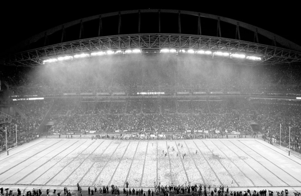 9 points
 -
Up to 3 fluffy inches. Still ripping, radar doesn't seem correct at all.7 points
-
Just had a flash of lightning and thunder here with sleet. The sky is really strange looking right now.7 points
-
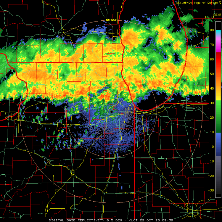
Got awaken by several loud rumbles of thunder and heavy rain this morning. My gutters are over flowing with water and I'm seeing reports of over 2" of rain so far in the southern burbs. Speaking of thunder, our local photographer captured this shot of a triple bolt that hit Trump Tower around 2:15am...this guy never seems to disappoint us with amazing photos.
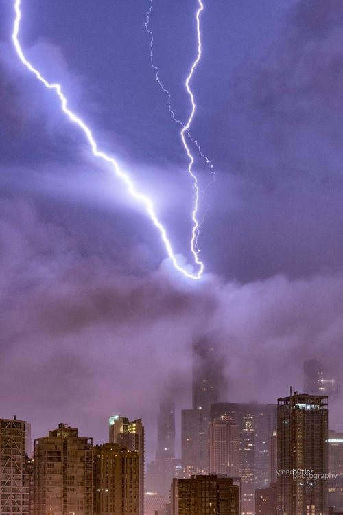 7 points
 -
The stadium appearance of the eye wall never gets old...enjoy! Here is a short clip of the hurricane hunters entering the eye wall. Bless these guys as they must have nerves of steel doing what they do best. https://twitter.com/i/status/1319081639922860034
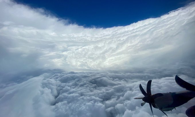
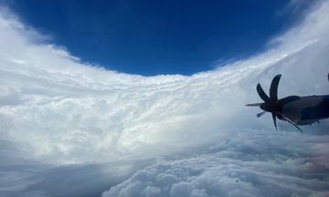 7 points
 -
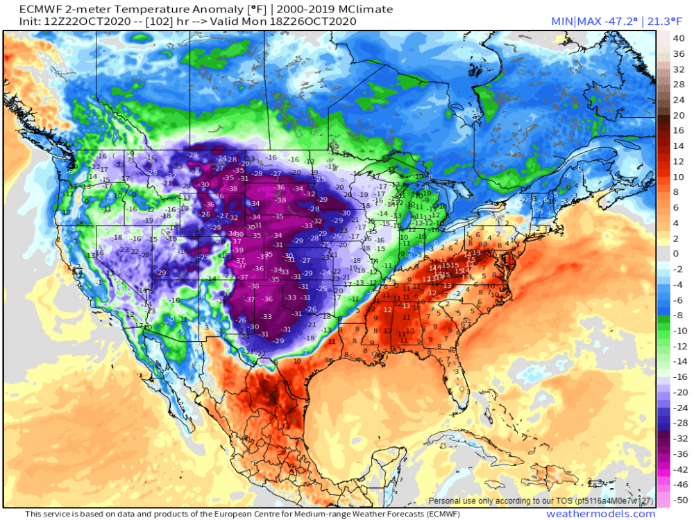
Need to keep these kinds of contrasts as we get deeper into winter!
 6 points
 -
Here's the reason why the skies are so dark over IA/MN and nearby...smoke has make an appearance... https://twitter.com/i/status/13192774607567298626 points
-
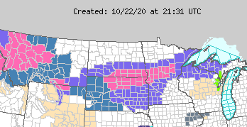
GFS ensembles starting to move toward a solution for the Sunday-Tuesday storm. EPS not as bullish.6 points
-
This is some high ratio stuff. I haven't really had any appreciable rates so far and it's already accumulating decently.6 points
-
It's 42 degrees and there are thunderstorms all around. What a weird day of weather.5 points
-
Downpouring and temp has dropped to 37. Only made it to 45 today. Forecast a couple days ago had low 70s. Front stayed south of guidance.5 points
-
80 currently in falls city ne, 52 in nebraska city. Pretty sharp temperature gradient.5 points
-
Elevation and drier air. Diurnal temp swings can be insane there on a clear day.5 points
-
Crazy sky. Snowing like mad now here on the Minneapolis/Roseville line. I heard the thunder but didn't see the flash. Good stuff.5 points
-
GFS is slightly weaker toward my area for late weekend but still not bad. I mean it is October after all. Nice to see the other models and DMX jump on board! GFS for the win?5 points
-
It's absolutely pouring out there right now...been getting waves and waves of heavy rainfall. I'm hearing of a lot of ponding on the roadways and highways causing traffic jams during the morning commute. These rains should put a big dent into our deficit.
 5 points
 -
Some LR thoughts on this thundery and rainy morning...the latest JMA weeklies are in and they show a continuation of the BN temp pattern through the early part of November before a relaxation of the cold appears to be in the cards later in the 1st week of Nov. Week 2 temp/precip...drier pattern overall... Week 3-4...temp/precip...the model seems to be building up cold in western Canada and bleeding into the Rockies/Upper MW whil the west & east coasts of the U.S. are warmer than normal and seasonal weather throughout the majority of our Sub. When looking at the Northern Hemisphere 500mb maps for Week 2-4, what stands out to me is the impressive and long standing Scandinavian Ridge. Dr. Judah Cohen has mentioned in his blog that if this block continues into November, it will have big implications on the Polar Vortex and could/should weaken it considerably. As always, it's a wait and see what happens with this wild card atmospheric feature. Lastly, our current state of the SST pattern continue to show the strengthening La Nina and a growing cold pool NW of Hawaii while warmer waters are beginning to "hug" western NAMER. Doesn't that look like eye candy??? Interestingly, the recent run off the CFSv2 is showing this pattern to continue into November...
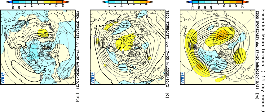
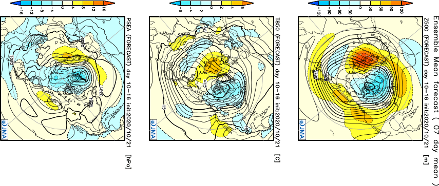 5 points
 -
5 points
-
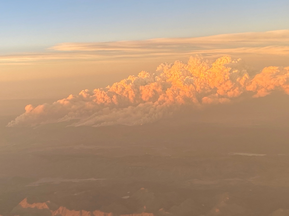
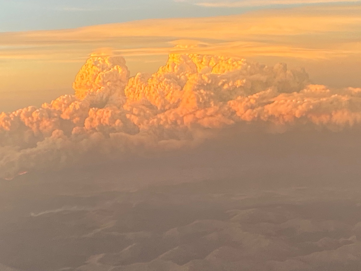
I posted these the other sub forum, but interesting pics flying past the Cameron Peak Fire in Colorado today.

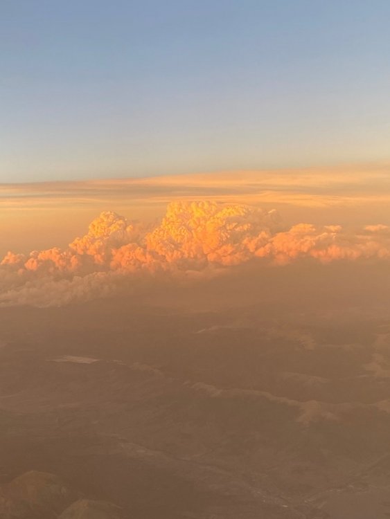
 5 points
 -
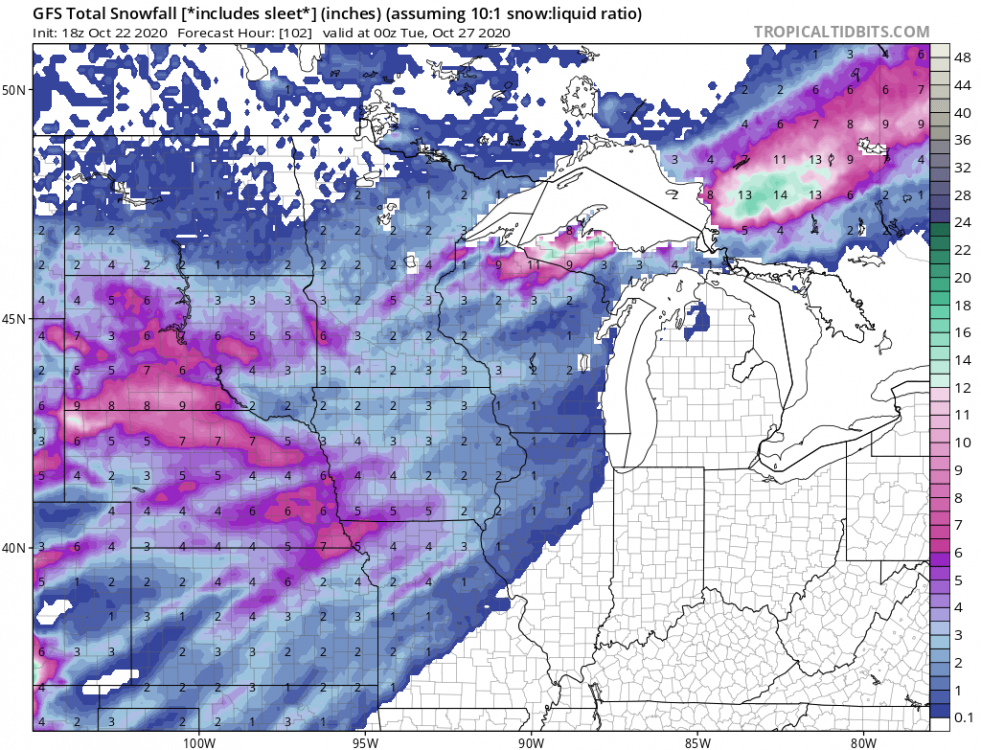
I think this is my first event topic, so we'll see how this goes The main potential looks to be for members west of the MS river. Even OK and TX may get in on some action later on. Can Lincoln get 3 Octobers in a row with accumulating snow? 18z GFS:
 4 points
 -
Crazy weather. I've been 36-37 for the past few hours with full on t-storms. My dish went out a couple times. This has been one heck of a pattern.4 points
-
In other news, Trump just signed into law the Space Weather Bill. It basically allows the government to have access to many more assets to study space weather and the relationship between the Sun and Earth. https://spacepolicyonline.com/news/president-signs-proswift-space-weather-bill-but-with-caveats/4 points
-
Whoa. 37 here with falling temps and a wind chill in the low 20’s. Low clouds make it feel worse.4 points
-
Loving all this from Des Moines NWS. Snow and potential record cold on the way! Sunday Snow: Another trough will develop late Saturday Night into early Sunday morning across the southern Canadian Prairie Provinces, and surface lee cyclogenesis will again occur in response to this. This system will have rather robust dynamics with it, and likely will have areas with enhanced frontogenetical forcing. Convergence in Iowa will not be hard to come by on Sunday. What is interesting, is that the 12z GFS has tracked the surface cyclone further south, but the ECMWF tracks the center further north through the Ozarks Region. Regardless, it is still looking like a widespread precipitation event for Iowa on Sunday. Ensemble means for Sunday with respect to QPF have a widespread 0.10", but several members in multiple locations depict as much as 0.40". If a track similar to the GFS occurs, the air will be quite cold, and most of the precipitation would likely be snow. However, if the track remains further north, there likely will be periods of rain followed by snow, dependent on when the temperatures drop again after the center of the low has pushed east. In addition, a north vs. south solution will also impact how much moisture works back into Iowa ahead of the low pressure. As mentioned at the top of this section, there likely will be frontogenetical bands that develop as this system passes by, and could result in some locations of the forecast area having snow accumulations that would require headlines. For now, will be conservative with the forecast and let today`s system pass by, and allow subsequent runs to better depict the dynamics and additional ensembles address the uncertainty with QPF and temperatures for Sunday. But, be prepared for wintry impacts Sunday and maybe early into Monday morning. Extended: Long range guidance in decent agreement with with trough acquiring positive tilt as it propagates away from the Rockies. Closed low over Hudson Bay moves south, forcing the flow further south and allowing the trough to dig toward the Gulf Coast. This will allow a strong Polar Airmass to move into the Upper Midwest, making for unseasonably cold conditions across the state. This will lead to a high potential for daily overnight low temperature records, and may even lead to a few locations achieving daily record low maximum temperatures. There may also be a few perturbations in this flow leading to wintry precipitation. More details on precipitation in the extended will be better known at a later time.4 points
-
Temps keep creeping up and now sitting at a balmy and humid 78F! Wow, it feels like Summer. No joke. I think I’m going to grill my marinating chicken thighs instead of leftovers from yesterday along with grilled Zuchinni. #WeberTime4 points
-
The warm front moved through here at 3:17pm. while I was mowing the lawn in short sleeves! It was mild with an east breeze then suddenly the wind shifted to the ssw. and warmed up some more. Usually the wind slowly shifts around with a w.f. but this was a strong front. It’s in the mid 70°s with a dew in the upper 60°s while it’s winter across nw. Ia. all day!4 points
-
This is what an active winter (errr..autumn) looks like! Storm Watches hoisted while current storm headlines are still rolling. Can't remember the last time I was personally enjoying that situation. It's been a while for sure.
 4 points
 -
A couple days ago it was supposed to hit the mid 70s today and instead the high was 45.7 at about noon and now it's down to 40.3. Had light drizzle and mist all day only totaling .09" so far.4 points
-
So wpc finally on board massive shift from this morning.4 points
-
Barney rampage as far down as Western Texas.
 4 points
 -
Euro looking pretty nice. Its coming around....4 points
-
Flurries for me… I’ll take it!4 points
-
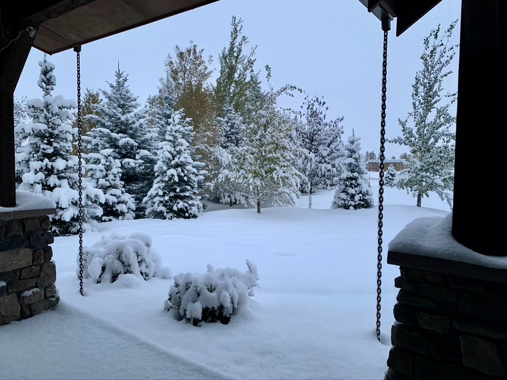
Ended up with 7" of snow last night. Looks like town had similar amounts as well. Dropped down to 16F, currently 18F. Still on track for another 8-12" Friday night into Saturday.
 4 points
 -
Today’s Skykomish view, cannot see it in the pic but there is snow on the trees on the far ridge line.
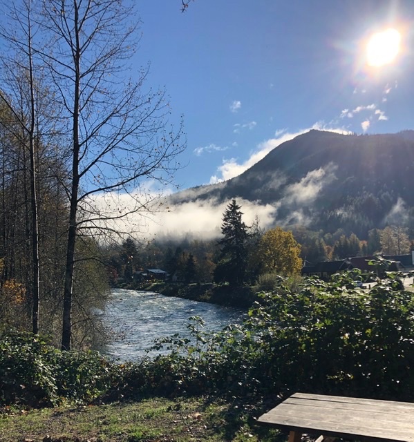 4 points
 -
Gonna make me start watching models now too, lol. Thx for commenting on this. Maybe Nina comes through for us, eh?? Here's what skiers out west are thinking about it..
 4 points
 -
12z ICON out with it's coldest and snowiest solution so far.4 points
-
Actually ripping pretty well now. Like I said earlier, this stuff is high ratio so I'm up to an inch now. 30.4*F.4 points
-
30 degrees this morning, my first freeze. My average is Oct. 31st so close. 192 growing days, not far from average as well. The graph shows growing days since I started this station in Battle Ground in 2011.
 4 points
 -
Local wx station is reporting a 2-day total of 2.62" of rain...I'll take it! Just got back from a walk around the neighborhood and everything is soaked. It's that quintessential autumn-like day with cloudy, dreary skies, cold and damp weather. Currently 49F with calm winds. It will be one of those days where we see 2 seasons as low 70's are in the grid for late this afternoon. Hopefully skies clear up quicker than models show. Didn't realize there was a Flood Advisory hoisted...4 points
-
Pouring out there currently and steady at 43°. Saw some lightning on way to work. I'm curious how far north that warm front gets today.4 points
-
Convective sleet quite possible today here in the TC metro. All of this rain I've been hearing about over the last few days is going to stay mostly mixed precip now, which is good. I don't want the rain with the snowpack still around. Still 7" officially otg at MSP as of the 2am report.4 points
-
Currently 33 degrees at my home in SLE. One more degree. Let’s go!4 points
-
SLE hit 34 before midnight, that was nice to see.4 points
-
6z NAM - By far the coldest NAM run yet, especially Gorge/Cascades east4 points
-
Down to 39 here already. Easily the coolest evening of the fall so far. Shouldn’t be too hard to fall well below my seasonal low of 38 which was set last Wednesday night.4 points
-
Euro weeklies
 3 points
 -
I agree. It would be silly to split us up into different threads. We can all be big boys and girls.3 points
-
12z UW WRF-GFS 8 AM Sunday Cold!3 points
-
Yes sir ..its the elevation. Its at 3,605' and in case you are wondering, their mayor there is Ginger Nelson. Added a little bonus for ya there pal. Btw: elevation does play a major role. Dont forget that!3 points


This leaderboard is set to Vancouver/GMT-07:00