
Leaderboard


Popular Content
Showing content with the highest reputation on 01/02/21 in Posts
-
Hey everyone! I have been loving the life here in Spokane WA. So glad to leave western WA (the swamp) behind. Had numerous snow since living here. Recent storm brought about 5 to 6 inches here in Spokane Valley. I will share more as winter progresses. Been very absent this year, since our move.12 points
-
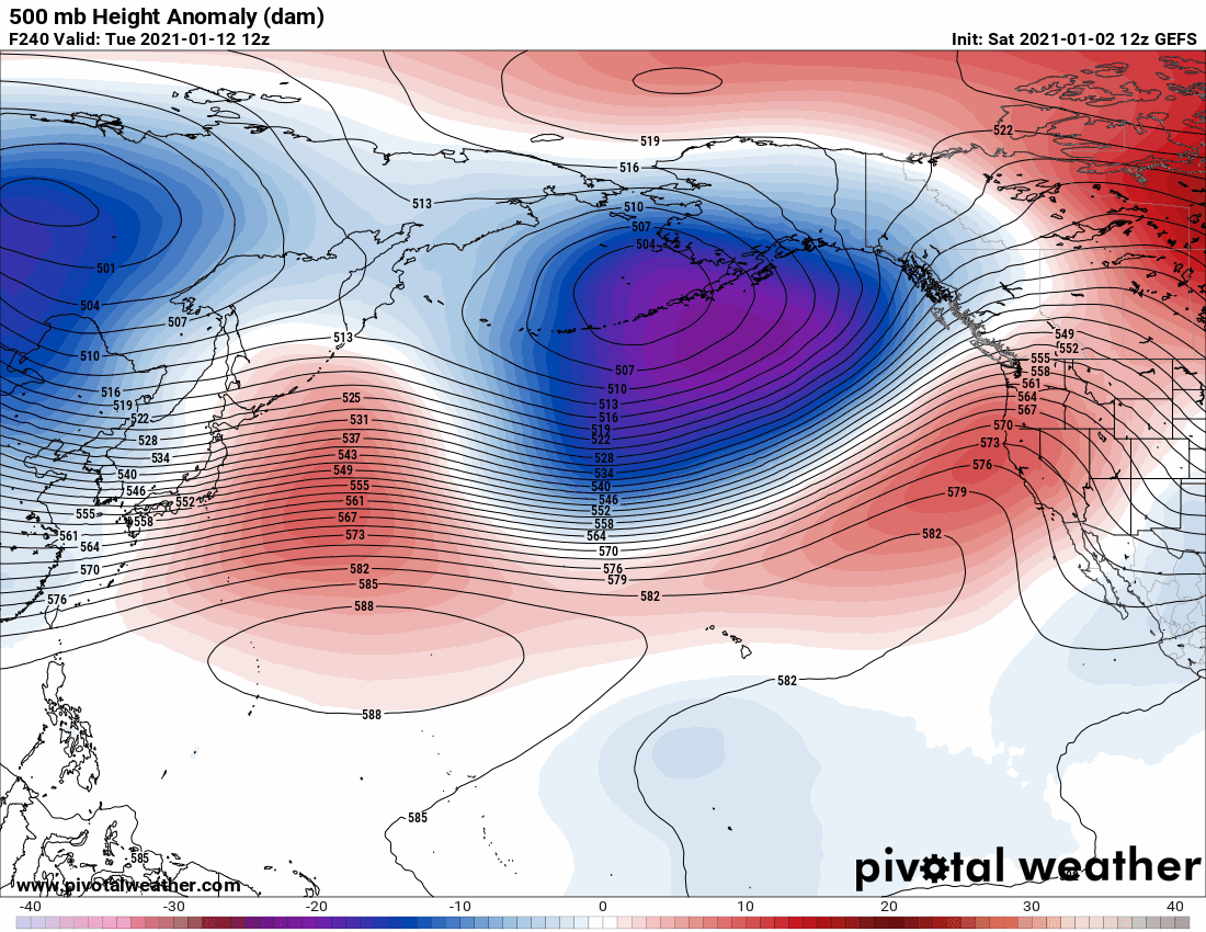
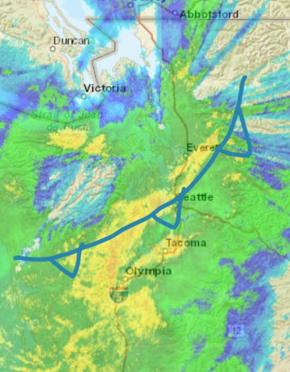
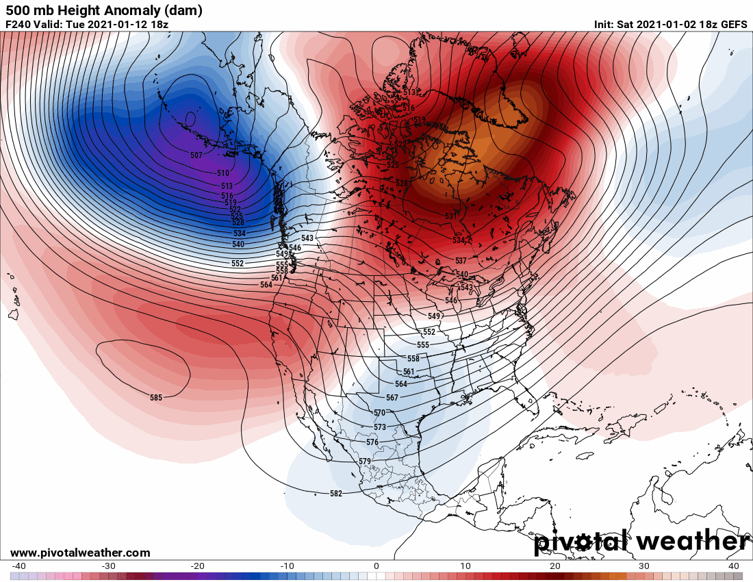
The models just haven’t realized the SSW. When it happens a strong ridge of high pressure will set up in the GOA. A strong low will advect down the B.C. with a 1060mb high already in place to the north causing sub-freezing highs in the PNW. As the low rounds the base of the trough heavy snow expand across the Olympics and into the lowlands. The trough tilts negative and moves slowly to the North and East due to the blocking high. Heavy snow bands train over the same areas. Seattle records almost 2 feet of snow. Fresh Arctic air behind low keeps snow on the ground for over a week after the event.9 points
-
3.38" of rain here so far today, already 4.88" MTD.6 points
-
12z GEFS looks excellent with what appears to be continuous retrogression beginning around the 12th and jet retracting. CMCE similar. EPS showing signs of it, but a bit slower. Everything to me appears on track for a cold and fun back half of January through the 1st 10 days of February. Very encouraging. C'MON!!!!
 6 points
 -
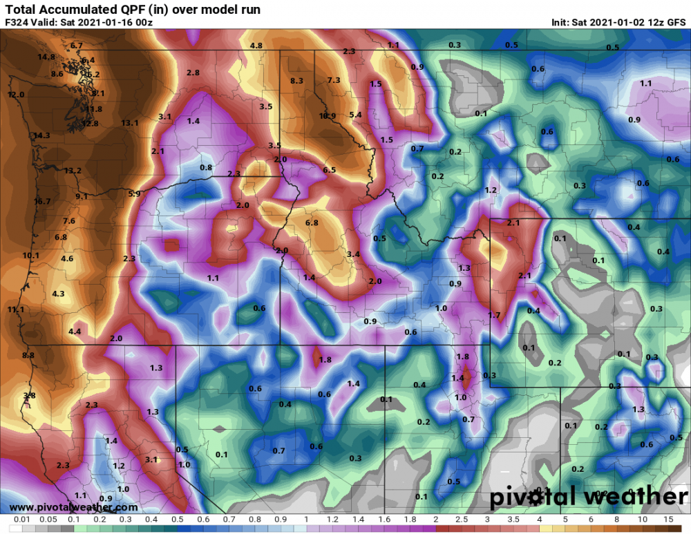
12z GFS is insanely wet. Precip totals through hour 324
 6 points
 -
Not too shabby5 points
-
Lol there’s not even a rug to pull yet.5 points
-
Yeah, here's the link to the map site in case anyone ever wants to play around with dates. They have it archived from 1979 to 2014. http://www.meteo.psu.edu/fxg1/NARR/1979.html Prettiest dates are probably going to be these two. What'd I'd give for even a GFS run that looks like these! http://www.meteo.psu.edu/fxg1/NARR/1989/us0203.php http://www.meteo.psu.edu/fxg1/NARR/1990/us1220.php5 points
-
It's coming. No one can stop it. You think the 18Z is an outlier. Maybe it is today. In the next few days the goods will show up on all the models. We'll be buried in snow up and down the I-5. I'm predicting 20.21" of snow in the swamp before it's all said and done. Book it Dano! It's coming and we are OVER due.5 points
-
More encouraging news! The 18z GEFS continues the trend with retrogression and the NPAC jet retracting. Timing has sped up a bit too. This run also builds heights over the Southeast US. Nice! C'MON!!!!
 5 points
 -
If we can actually score something big in the last half of January it would be the first time since 1996. Been way too long.5 points
-
The whole SSW process has trended into a more slow, prolonged displacement and shredding of the vortex vs a quick cut of the jugular. Now the major warming is just the opening act that throws the vortex off balance/tilts w/ height as it slowly bleeds out from follow up wave activity. So perhaps the pattern response will be of the slow variety as well instead of a quick flip.5 points
-
5 points
-
Really the only signal that matters in the LR.4 points
-
Winter cancel cancel?4 points
-
The PV split in 2008/09 didn’t take place until mid/late January.4 points
-
Some Serious Wishcasting4 points
-
Not sure how anyone posting here could have.4 points
-
I don’t know why people object. Heaven forbid that someone post weather forecasting model output on a weather forum!4 points
-
It wasn't an ideal setup for an inversion to develop, especially being later in the season with enough dry air advection to keep things solidly mixed for the most part. It really wasn't that short lived of a cold period at all, though. This was the initial push of cold from the NW on 1/31 http://www.meteo.psu.edu/fxg1/NARR/1989/us0131.php And then over a week later, 850mb temps were still well below average with the antecedent airmass still largely in place http://www.meteo.psu.edu/fxg1/NARR/1989/us0208.php And the next four weeks stayed cold with the PV hanging out close, there was a backdoor/Fraser River event at mid month http://www.meteo.psu.edu/fxg1/NARR/1989/us0216.php And then of course the big event at the start of March, the last really major March event for Portland and Seattle http://www.meteo.psu.edu/fxg1/NARR/1989/us0302.php4 points
-
Meh I don't care what hour it is it's just nice to see some arctic air build in Canada.4 points
-
It’s only a backdoor blast, but it’s a good place to start. Hopefully these signals improve with time, rather than being a blip in the endless sea of dullness.
 4 points
 -
According to my friend Davis, “it’s raining cats and dogs”. 1.11” on the day.4 points
-
Officially, Topeka 5.1" My house 5.6" (seasonal totals)4 points
-
Nice to see a wind advisory for the valleys and a snow advisory for the Cascades tonight, at very least. As has been said by others, the current pattern beats endless death ridging by a long shot. Although it would be great to see things turn colder and snowier at some point this month. I will say I am a little disappointed the jet won't be as suppressed the first 7-10 days of January as previously advertised on some of last week's runs. What looked to be a 2008 type pattern has morphed into more of a 2006 type pattern.4 points
-
I survived the warm-nosed and dry-slot dusting of 01/01/2021. Lol. What a way to kick off the new year all around me. I'm so glad. Many folks needed some snow and some fun and I'm glad to see everyone having a blast. That's what it's all about. Parts of okc and west are already a foot plus on the snow season. That's nuts.4 points
-
Get that forcing out of the Indian Ocean and that probably solves the jet problem. The MJO should be triggered by the SSW so I really do think it will happen. Really, it’s the only thing standing in the way of a big league winter pattern.4 points
-
Retrogression and bridging cross-polar highs. Nice ensemble run.3 points
-
I’m pretty sure I lost my virginity as a result of a splitting PV.3 points
-
It was strong aloft but tilted with height, and the lower levels were being blasted. That was a bottom-up wave-2 with a stacked Aleutian High all the way from the troposphere to the stratopause. Might be decades before we see another one like that.3 points
-
Back to back runs. Nice to see.3 points
-
Looks like the cold front just moved through here. Had a period of very heavy rain, wind switched from 30+ mph South to North and temp dropped from 47 to 45.
 3 points
 -
1988/89 and 2008/09 are the two most recent examples.3 points
-
Highway 2 can be the worst. A 30-mile-long back-up caused by the traffic lights in Monroe.3 points
-
Super snowy winter3 points
-
Later in the year for one. Then I think the ridge moved overhead.3 points
-
Every optimistic post by Jim must be countered by a pessimistic post by Tim or the fabric of reality itself will rupture.3 points
-
Yeah, I get it. It’s about as valuable as a twinkie in a Kansas 7-11. But the signal for some kind of pattern change, minor or major, is beginning to emerge. At this point I’m just glad to see pretty colors within 16 days.3 points
-
3 points
-
This needs a DJ MBG!3 points
-
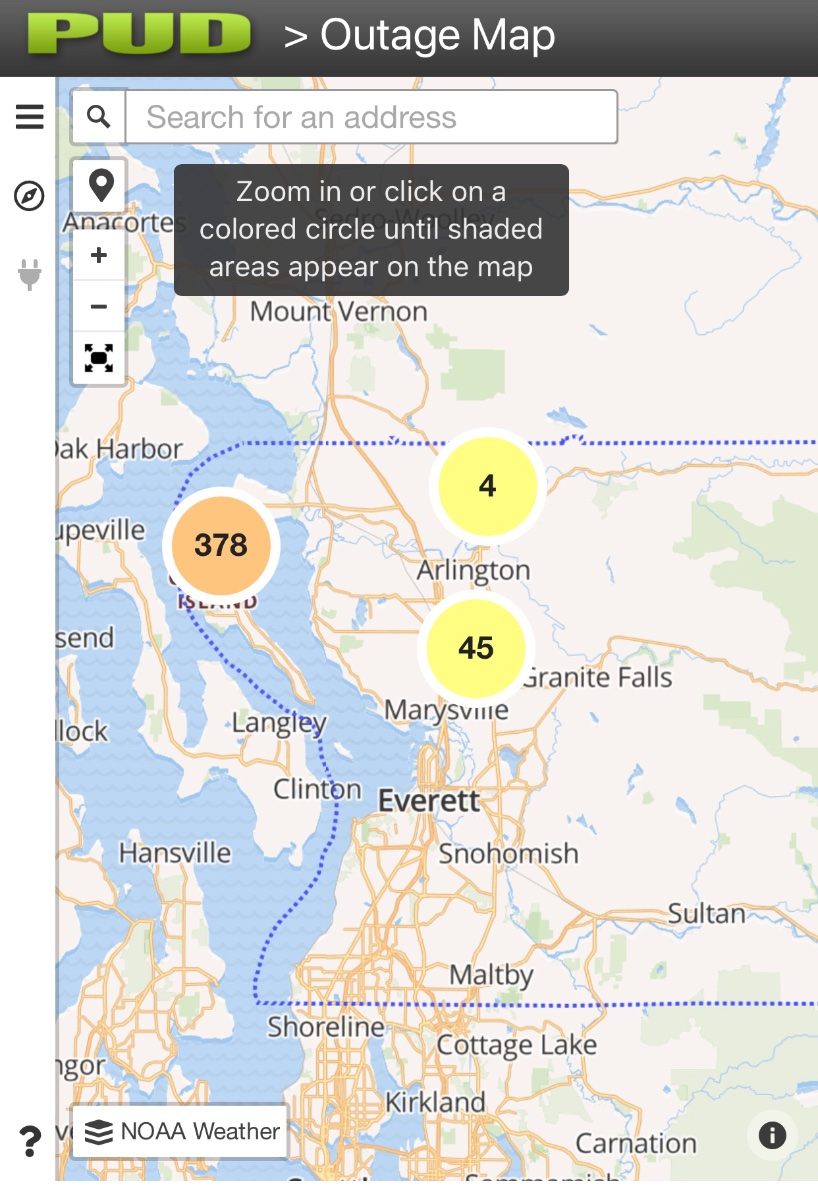
Big gust just now, rocked the house. Just checked the outage map, not bad yet.
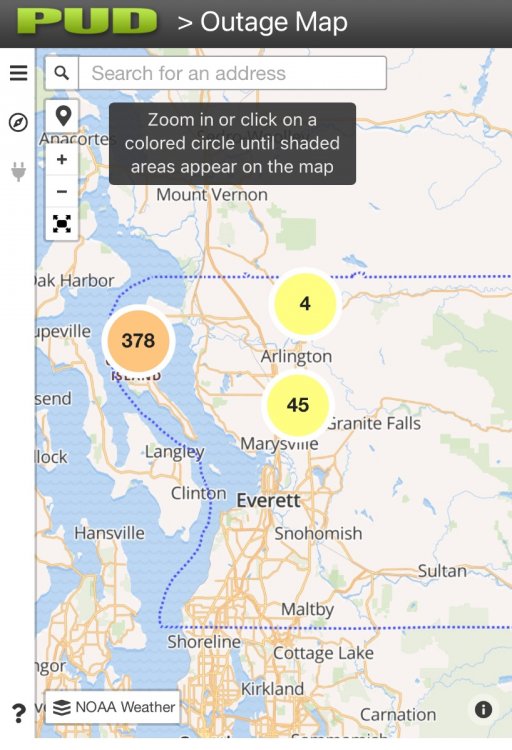
 3 points
 -
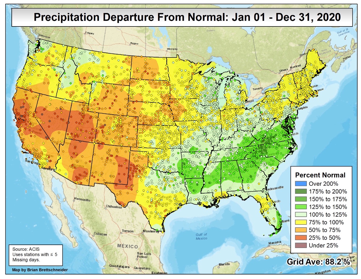
2020 precip, from the map god, Brian Brettschneider.
 3 points
 -
Snow between 10 p.m. and 4 a.m...3 points
-
Impressive radiational cooling right over the heart of the MW in parts of IA where temps have tanked into the single digits. Deep snow cover and HP will do the trick. Has anyone else notice their grid temps trend lower for next week? Especially those who keep adding to their snow pack around the MW/GL's region. I once had low 40's but now low/mid 30's are in the grid for next week. Speaking of snow pack, while we are going through an AN temp regime, I find it rather interesting that through the next 10 days the Euro is forecasting most of us to maintain their snow. If it holds true, that is #winning in my book. I forgot to mention, but I wanted to wish everyone a Happy New Year as we welcome 2021! The start of a new decade is upon us and what I believe will be the beginning of the "Roaring 20's".
 3 points
 -
ORD ended up with a whopping 1.3" when I for sure thought we would squeeze out at least 3" (on the safe side) from what the avg of all the models were showing. That warm nose crept about 50-75 miles farther north than expected. It ended up going as far north as parts of SE WI (Sheboygan/MKE area 4-5") which wasn't modeled until the nowcast moment. They ended up getting 3-5" and I think some of that was lake enhancement. We just didn't have the deep cold air in place to make it happen. End result, places in S WI got a surprise overachiever, as well as, one of our members in S MI who reported 5-6". Hey, the silver lining is that we finished with some "new" snow to cover up the "old" snow. On a positive note, Topeka/KS region got their first decent plowable snowfall in a long time. It looks like a solid 3-6" band set up right through E KS. Not only did they do well, but the hot spot OKC area got hit with yet ANOTHER snowstorm (6-10") and we shouldn't forget about our Lone Star state that got slammed with up to a Foot in parts of W TX. Crazy storm. I guess we'll have to see this part of the LRC cycle back in mid Feb. Till next time...3 points
-
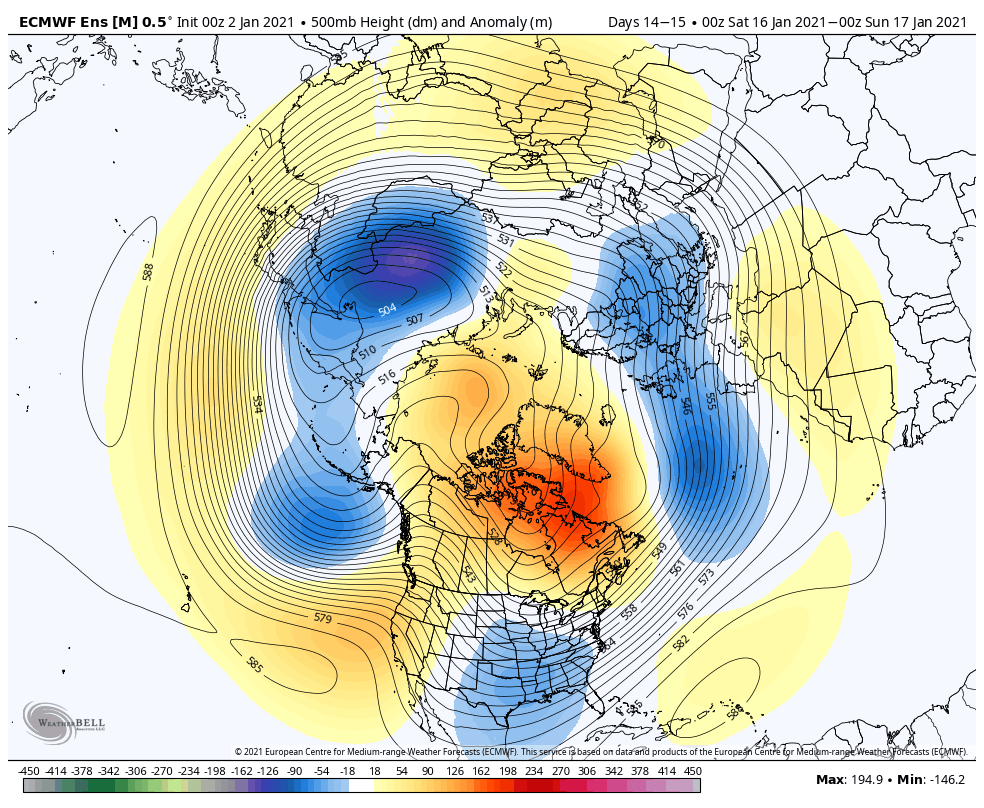
Weaker jet D12-15 but signal still hasn’t reversed yet. Russia still freezing to death. North America still warm.
 3 points
 -
The only thing you can say is this progression isn’t in the script. Like, at all. At least not since WWII. Not a single analog for a high amplitude Aleutian low and Eurasia/Barents High together with a SSW, west based -ENSO, and IO forcing/dateline subsidence. If you take the instraseasonal signal by itself and ignore ENSO then you end up with a real nice, blocky pattern for the second half of winter. But can you actually do that? Or is there a nonlinear relationship to ENSO/low pass that will produce a different outcome this time? Fascinating either way.3 points


This leaderboard is set to Vancouver/GMT-07:00