
Leaderboard


Popular Content
Showing content with the highest reputation on 01/13/21 in all areas
-
Everybody when there is model variance11 points
-
18z Ensemble is colder than the 12z, especially out this way. Deep breaths everyone. 12z. 18z
 9 points
 -
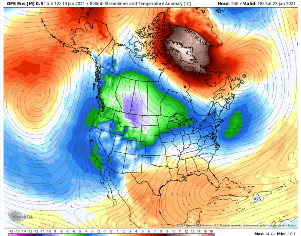
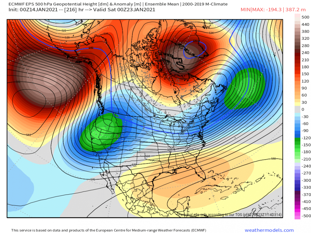
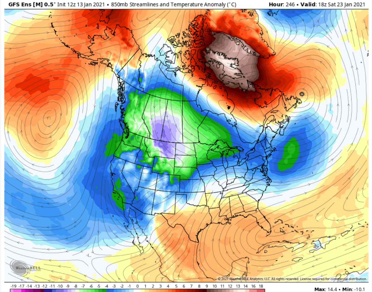
EPS has a stronger ridge, deeper trough, and colder 850s from about day 7 through at least day 109 points
-
It also is the method for delivering us a nice snowstorm on each of the past two runs. We'll take what we can get. The block is still largely in place right on through the end of the last two GFS runs. It's a nice pattern for sustained snow and cold opportunities.9 points
-
Let's keep the AGW and Political talk separate from this board as there are several members on here (including myself) that would rather discuss weather related business in here. You can choose to contribute in a a different section of this Forum in the tab below: https://theweatherforums.com/index.php?/forum/20-long-range-forecast-and-climate-discussions/9 points
-
You would think that the people in this forum who have been looking at these models for years would have learned that by now. You would think.8 points
-
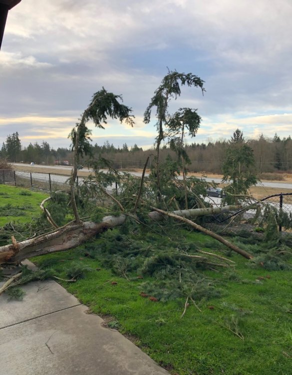
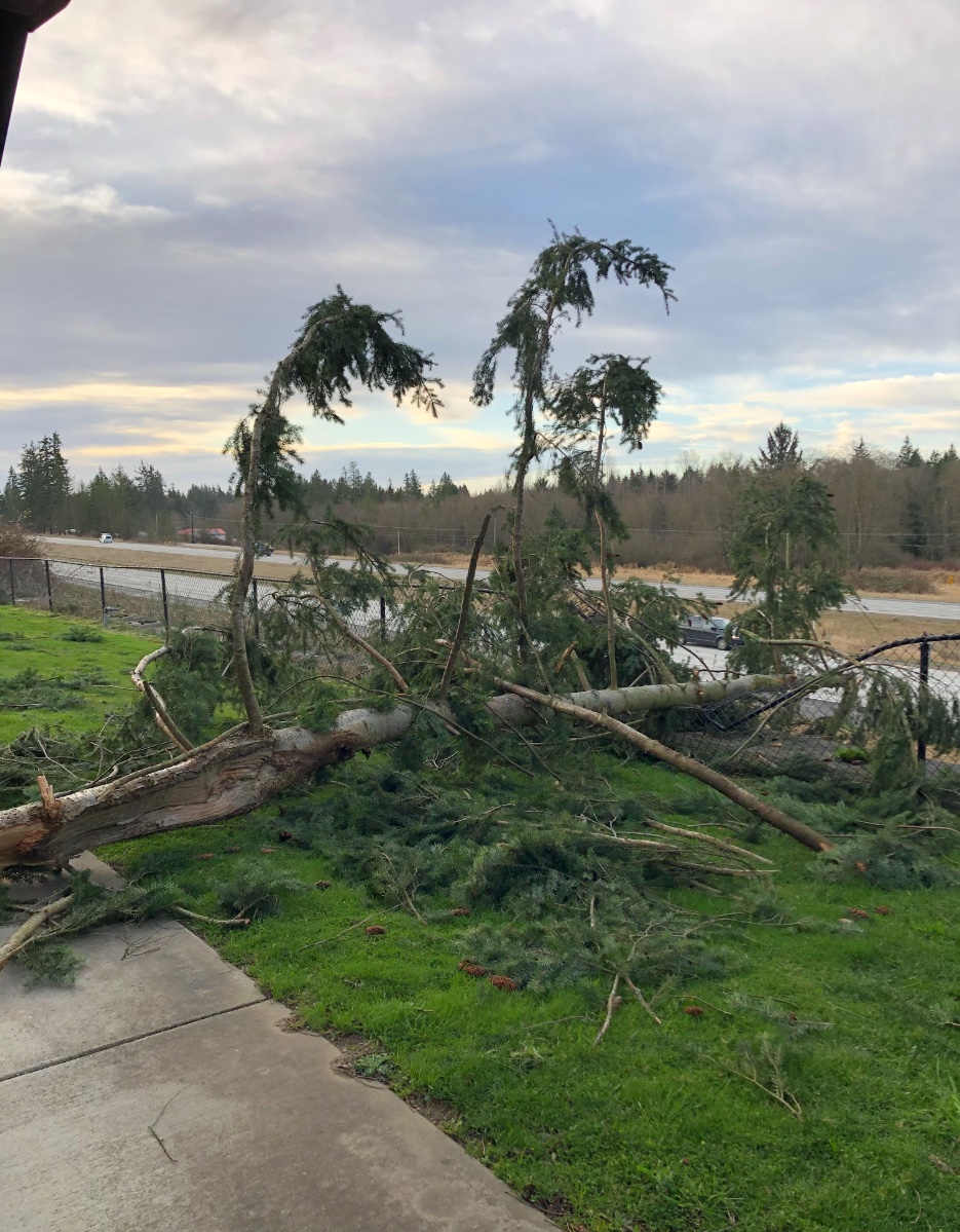
Well this night will be added to my memorable wind events...Could hear crashes in the distance at times and constant wind battering the house while I laid in bed in otherwise complete dark and silence (no fan running) That squall line that came through sometime shortly after midnight was amazing!!! The power surged non stop for about two minutes though so hopefully not everything is fried in the house that wasn’t surge protected. Will be interesting to see if I lost any trees on the property, need to inspect my fence line at daybreak. GOOD STORM!!8 points
-
Got a weathermodels subscription. Probably will cancel when winter is over. Anyways, much stronger signal on the EPS than the 00z which means more members are agreeing on the upcoming pattern.7 points
-
Quite a bit better6 points
-
EPS definitely a stronger more improved signal through the end of the run. It does drift too far west like it's been showing though. But this is a pretty good week 2 signal6 points
-
Yep he did, the EPS is improved over last night's run through day 10 (where it's currently at)6 points
-
I think you misunderstood him. EPS better through hour 240.6 points
-
MPX doesn't need the Euro's 12z run to confirm. They've pull the trigger on a Winter Storm Watch for 6-9". Blizzard conditions possible to the south and west.6 points
-
I'M ONBOARD.5 points
-
Not trying to be political. Just found it weird how low solar activity is correlated with impeachment’s. Weird coincidence
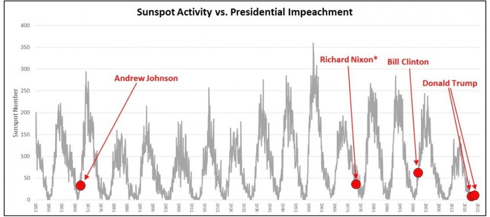 5 points
 -
They asked if they could use it, nice to see that they did. Thanks for spotting this5 points
-
2nd consecutive GEFS run where the ridge doesn't seem to exit stage left (West) like had been the case for several days. Hopefully the EPS follows suit.5 points
-
Power out here so the generator is up and running. Ended up having a few gusts to 45 mph which ties my record high. Pretty sure this was the strongest storm since the Hannukah Eve Storm. Took a drive around the area and saw probably over a hundred trees down. If I followed all the road closed signs I wouldn't have actually be able to leave my road as there are lines down at one end and a leaning power pole at the other. Couple houses in the neighborhood also have trees down on them although it doesn't look like much serious damage.5 points
-
Trying to pinpoint any winter event is tough enough. When a "L" gets vertically stacked and basically cut off from the upper level winds is near impossible. This will come down to now forecasting with radar. Trowals esp.5 points
-
whatitdo- I will respond once to this thread and that will be it. First off- not a degreeed MET, but i have been pretty much grandfathered in with my job as one and work with several. Most MET's actually agree with Climate Change, but how is the question. Most MET's DO disagree with AGW (man made to the extent it's shown in the media) but will revert to "I agree" or they suffer "set backs' in their career. Trust me. Seen it happen many times on the broadcast MET front with many tv people let go because of their beliefs agst full out AGW. If you want a list- I can provide it. Many i know personally. I could go on and on and on about many data points that point to a natural variation in climate being induced as AGW- one is urban heat island, but I know - that of course gets thrown out. I understand why- but no way is DSM IA going to break the all time min of -30F set on JAN 5th 1884 when official measurements were taken in river valley. If FEB 1996 didn't break it(-26F) at the Airport - with all time record lows set in MN,IA,WI (-47F in IA) nothing will. My point before I leave is that it's not apples to apples when you compare temperatures from even 30 years ago. Enjoy you day- but this is the last post I will have this topic in this thread. Peace out.5 points
-
Looks like this Nina winter is starting to wake up a little.5 points
-
The pressures being forecast in SE BC, north of Spokane, were very anomalous. 1 in 10 year event. Makes sense Spokane would get nailed.5 points
-
from Mass: “Let me be honest.....meteorological guidance underplayed this seriously. We knew it would be windy, but the forecast models (such as the UW ensemble) were only suggesting sustained winds of 15-20 knots with gusts to 25-35 kt” ——— I understand the need to rely on the GFS/GFS blend, but to say it underplayed it is wrong. Like I said in the previous post, the Euro was quite bullish with the windstorm and so was the NAM... 24 hours leading up to the event! both of which seemed to be correct. The NWS didn’t even sent out an advisory until 8pm last night after the GFS decided to jump on board. This will be an unpopular opinion, but as a weather and climate enthusiast, I’ve learned to move away from the GFS last few years and rely more on the ECMWF. But the experts seems to be having a hard time. Maybe it’s time some of us do the same.5 points
-
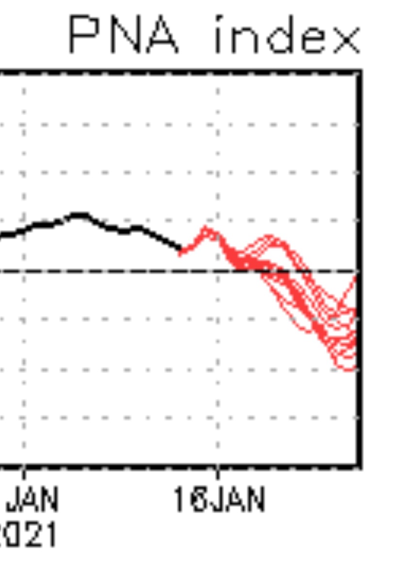
Here is your good morning PNA update. That one Tim member needs to settle down!
 5 points
 -
I work in a warehouse and here's a live update from my work lol. My shift starts at 6am and power went out at midnight. We were all sent home. According to PSE no ETA when it'll be restored
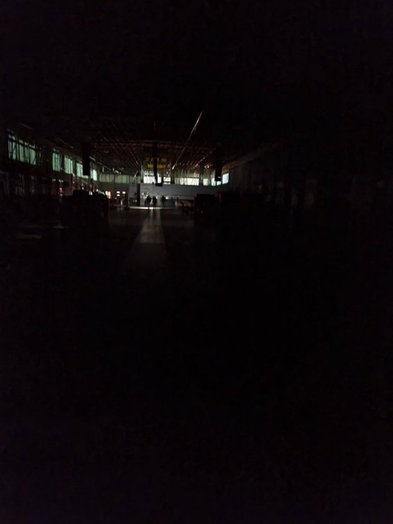 5 points
 -
Major event for Spokane, sustained 49 gusting to 64mph from the west at 7am.5 points
-
Was 55 when I went to bed, it’s now 40 degrees and still quite breezy. Walked my fence line in the woods and luckily no trees across it. Lots of branches everywhere however. This is how winter should be!5 points
-
52mph gust!5 points
-
EPS hour 216
 4 points
 -
Latest update is no power until tomorrow night at the earliest. So glad we got this generator. 6th power outage since Labor Day. Good lord.4 points
-
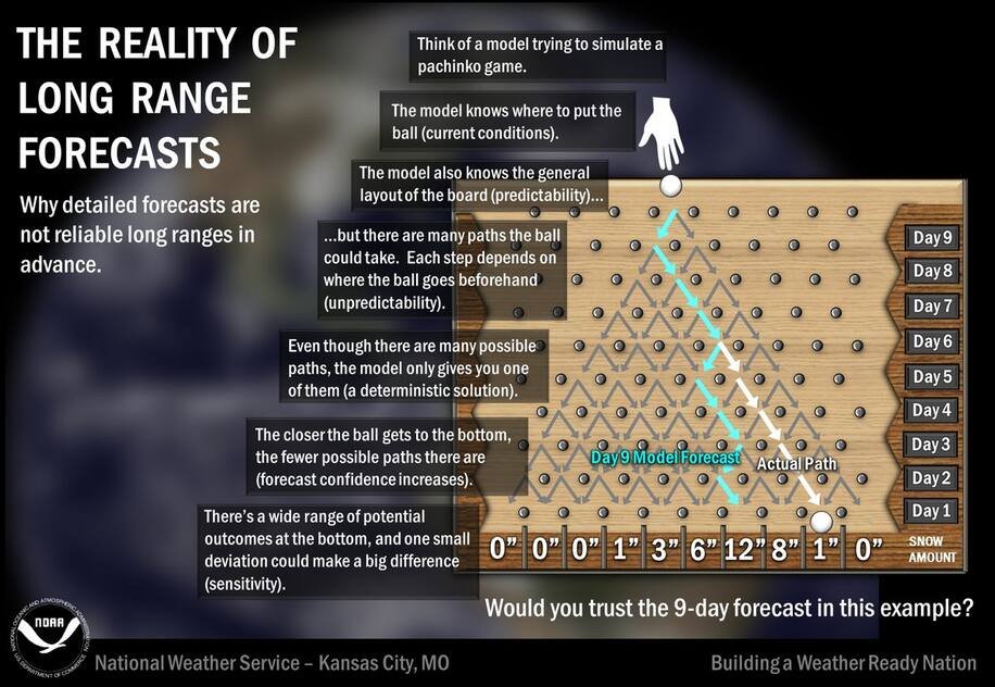
This is literally the best analogy I can come up with. An early error in day 3 or so as an example can throw the whole thing off. https://www.washingtonpost.com/news/capital-weather-gang/wp/2016/12/06/heres-why-computer-models-ten-days-into-the-future-cannot-be-trusted/
 4 points
 -
Power just came back on-- what a weird windstorm. Just some howling west winds for an hour or so that were strong enough to down a bunch of trees in this area. Overall a pretty interesting event, south winds were underwhelming but that surge of westerlies made up for it.4 points
-
Both GFS ops today are basically worthless because they put that cutoff right in the middle of the ridge merger. No other model or ensemble shows that. The progression is completely affected by that after it. Both runs are different with the handling of that.4 points
-
How the sneaky low snuck up on us and only the Euro saw it coming as it developed literally at the very last minute. GFS among other models needing a lot of work.4 points
-
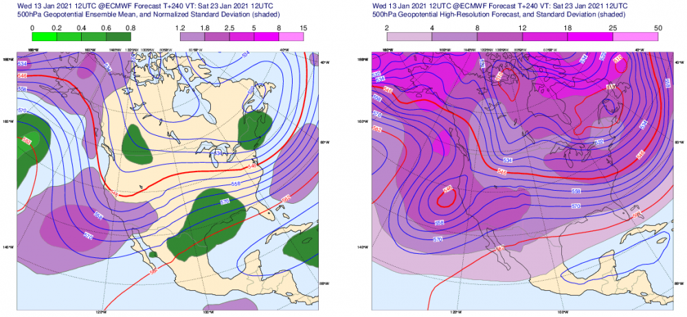
12z EPS at day 10 vs 12z Euro operational at day 10:
 4 points
 -
Spokane airport reported a 71 mph gust this morning. If that's confirmed it will be the 2nd strongest wind ever recorded there I believe.4 points
-
EPS still better through hour 294.4 points
-
Went to work for a bit, this chunk of tree just missed the building but did nuke the fence. Cell tower is down and no power so I didn’t have that option for working on my phone, so I came home to work. No power here as well but I have the satellite internet running on the generator. What a lovely storm that was...Hopefully just the warmup to the epicness coming soon!
 4 points
 -
The GFS and parallel GFS both have a weak system moving through the region early next week, followed by a more significant system around Jan 23-25.4 points
-
no worries my man i sincerely appreciate the input. We could discuss the AGW stuff in another thread sometime if that were to happen. FWIW I do agree there is an amount of unfair and lazy comparisons about this topic in the sense you have alluded to on both fronts. Have a good day as well!4 points
-
Looks like PDX scored two 60s for the price of one around midnight. At this point it will basically require a pattern like the 06z to avoid a top tier warm month.4 points
-
4 points
-
Lights flickered a teensy bit when I was reading before passing out last night. Didn't wake up to a 150ft tree in my bedroom and didn't lose power at all.4 points
-
Serious winds coming ashore now in Strait of Juan de Fuca- Data at: 0904 UTC 13 Jan 2021 CWQK 130800Z AUTO 27049G60KT 08/ RMK AO1 PRESRR PK WND 27063/0742 SLP972 T0078 53034 CWSP 130800Z AUTO 28046G53KT 08/05 RMK AO1 0PAST HR PRESRR 3034 PK WND 26064/0712 SLP972 P0004 T00820051 50014 CWLM 130800Z AUTO 26035G54KT 08/06 RMK AO1 8PAST HR PRESRR 3015 PK WND 27054/0758 SLP956 P0019 T00770062 50080 KNUW 130856Z 27042G56KT 6SM -RA SCT012 BKN028 OVC085 09/05 A2955 RMK AO2 PK WND 27056/0849 WSHFT 0806 SLP006 P0009 60013 T00890050 53057
.thumb.png.08db03f1d6a97fb48aee66940eed4a14.png) 4 points
4 points -
He hates these cans! Stay away from the cans! FullSizeRender.mov4 points


.png.ccbf4692786e2e5f3c6ac388e1879f68.png)

This leaderboard is set to Vancouver/GMT-07:00