
Leaderboard


Popular Content
Showing content with the highest reputation on 02/25/21 in all areas
-
This will help out for a few days, but I would expect plenty of red flag warnings in the Dakotas over the next few weeks given the lack of snow there this winter. They entered winter with drought conditions as it is.3 points
-
Lincoln is up to a -16.6 depature for the month. Plugging in the forecast for the next few days puts us at around -14. It's still going to be the 5th coldest Feb behind 1899, 1936, 1978, and 1979. For a while I thought only 1899 and 1936 would be ahead but I always forget how cold the late 70s winters were. Feb 1978 had a max temp of only 41, even 1936 hit 53.3 points
-
It's going to be an above normal March. It's pretty much a lock at this point. All spring? who knows. But March will be nice.2 points
-
I'm thinking a truly warm spring (MAM) is off the table. Fully expecting more shoulder season winter-ish stuff like we had for the NDJ period leading up to the arctic period.2 points
-
Today's JMA weeklies are showing the eastern Canadian blocking pattern that could put a wrench into any real warmth near the GL's region. The other kicker is the MJO could be heading into Phase 1/2 in the extended and that is not a welcomed signal for warmth. Monday's Euro weeklies sorta gave a hint towards that in the extended... The JMA's temp forecast over next 30-days... Precip... March MJO temp composites... Another LR clue for an eastern trough in the Week 2 period is the sudden crash of the SOI...this is a complete reversal of what has been weeks/months on the + side of things. It seems to me the models are loosing the blocking yet again in the LR over Greenland and eastern Canada as they did during the winter months where it will impact the wx pattern quite a bit in the early Spring months. Date Tahiti (hPa) Darwin (hPa) Daily Contribution 30 day Av. SOI 90 day Av. SOI 25 Feb 2021 1008.06 1006.40 -14.79 13.45 15.45 24 Feb 2021 1010.22 1006.20 -3.46 14.79 15.65 23 Feb 2021 1011.86 1005.55 7.54 15.24 15.75 22 Feb 2021 1012.44 1003.90 18.25 15.18 15.73 21 Feb 2021 1011.91 1003.05 19.79 14.73 15.55 20 Feb 2021 1012.36 1003.10 21.71 14.11 15.25
 2 points
 -
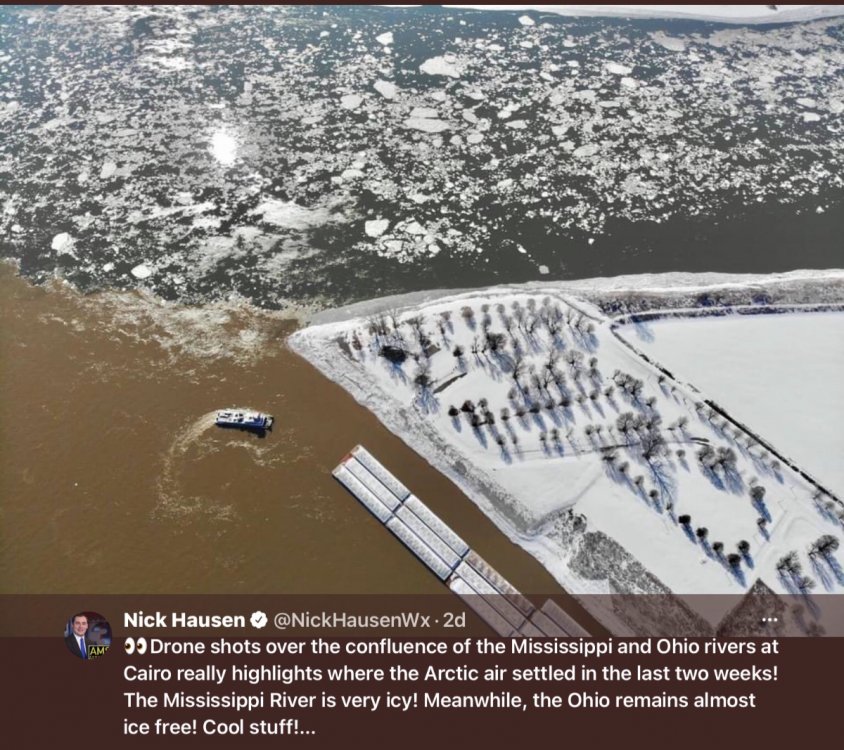
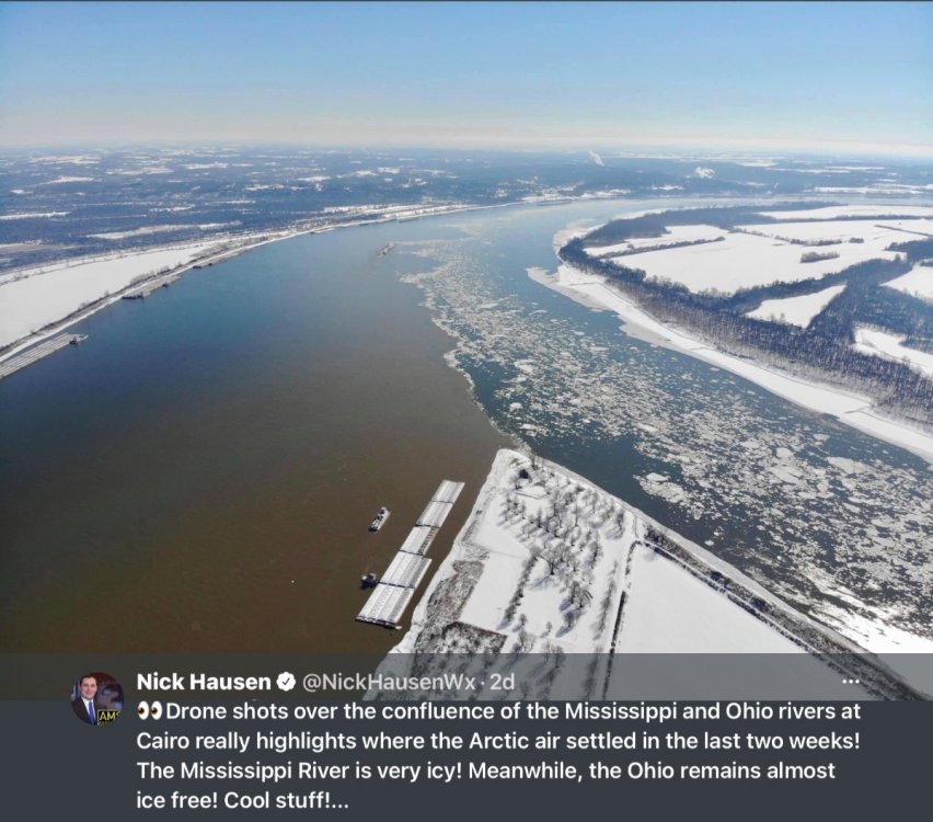
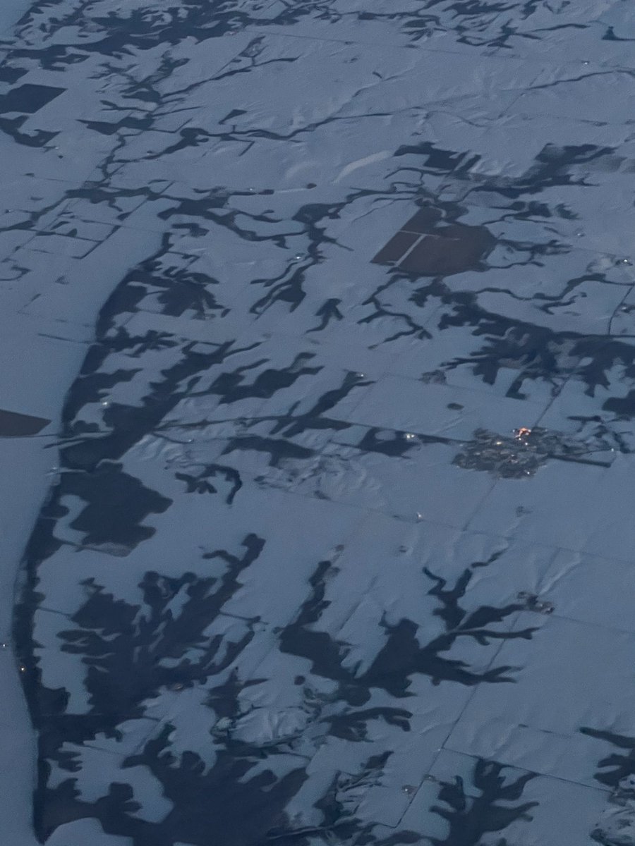
Interesting photos from a few days ago.
 2 points
 -
How are there data points clearly well into March on this chart? Doesn't make any sense.1 point
-
Worst case, destroy my ski hill then stop the lake from opening up. First world problems are so bad.1 point
-
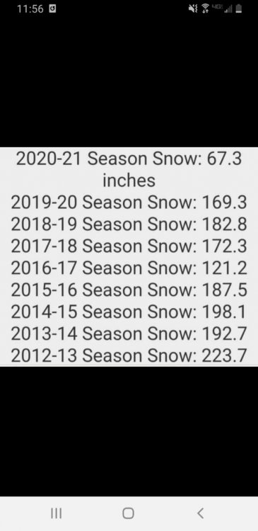
Lots of help....30 mi south averages 70". Thats probably the most crazy thing about this winter is not only the lack of system snow, but the non existence of the lake for the most part. Out of that 67", 10" fell in October as well. Just crazy!1 point
-
Your golden! It's going to be very nice down there so I wouldn't worry to much about cooler weather. I was actually thinking about visiting some friends down near Clearwater, FL around that time myself.1 point
-
That locale must get quite a bit of help off of Superior to avg 160"1 point
-
While this winter's total snow fall is only 44.8" This February will end up as one of the top snowiest February's in Grand Rapids history. We will end up at least the 6th snowiest and are still in play for the 5th spot. If Grand Rapids fails to reach 50" that would be the first time that Grand Rapids has not had at least 50" since the winter of 1986/87 And only the 4th time since 1950. At this time it is partly cloudy and 31 here1 point
-
Good lord what is your average when you still got 121" during the **** show of 2016-17 lmao.1 point
-
Buddy, I'm sorry. I know exactly how you feel though. I hope things are better next season for you.1 point
-
Looks like we're going to start March off and end February with low 40s, high 30s in SE Wisconsin. How disappointing, this winter was so good, but for snowboarding it had such a late start and probably an early end. Is there any hope for some cold anytime soon? 10 day forecasts all look bad, GFS said cold but I assume it was wrong and Euro was right.1 point
-
Back to back 46F and sunny days has halved Monday morning's snow pack. True winter was 3 week period for Mby. That's better than it was looking tbh. I could be fine with warmth in March.1 point
-
Good news is all the side roads and most of the drive is now snow free! still have a dense snowpack.1 point
-
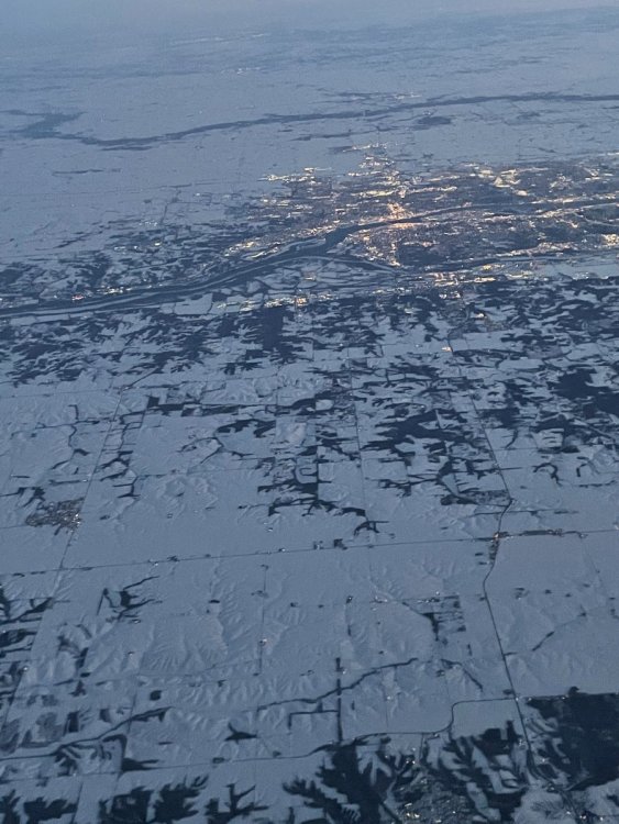
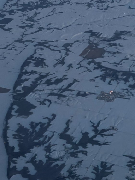
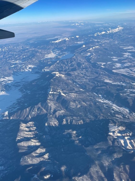
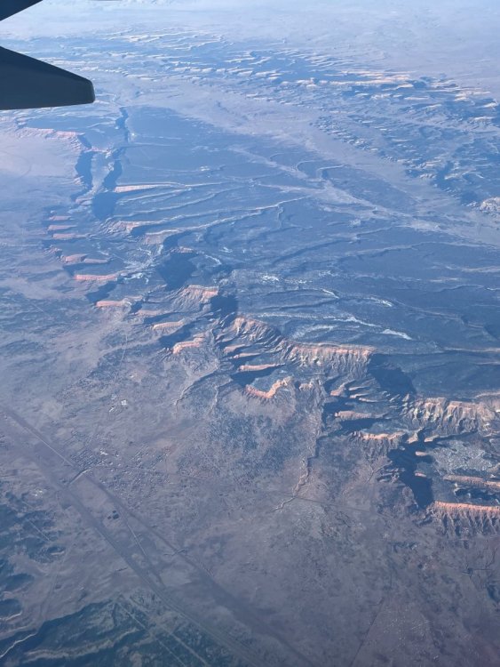
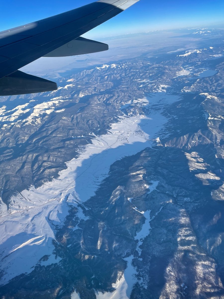
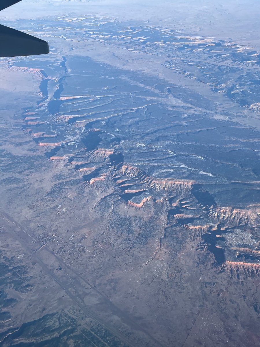
Once I saw the end was near, it was time for me to make my trip out to AZ. I wasn’t lying when I saw a potential pattern that could conceivably become historic and it did. I was open about it and admittedly delayed my trip. I’m glad I committed to it bc it was about a months worth of winter that I will never forget. The weather was about as ideal as one could ask for across the heartland. Clear skies, calm winds and barely any turbulence. I snapped these photos and vids along the way. Maybe some of you will notice the sharp bending of the Mississippi River and can tell me where this location was. My guess is near DBQ or NW IL!!?? The beautiful deep and expansive snow pack was evident. You can't tell from the pics, but with the naked eye you can see the rolling hills covered by a thick blanket of snow. We flew over a ski resort as well once inside IA. It could actually have been the one @bud2380 went to the other day. IMG_0177.MOV IMG_0174.MOV As we flew over IA and into NE (or maybe it was KS bc of the lack of snow cover), we approached the snow capped mountains of Colorado! What a gorgeous view from up top. The contrast of deep blue skies against the snow covered mountains was picturesque. Then we headed SW into AZ/NM and the geography changed quickly as the elevation dropped off fast. You could see the abrupt cliffs/plateaus below. IMG_0180.MOV

 1 point
 -
After a couple more years in Neb, my list looks a bit different. 1. Jan 25 2021: No explanation needed. Accumulating snow from before sunrise to past sunset. 12-16" in the Lincoln area. 2. Feb 23 2019: Blizzard conditions w/ snow already on the ground, 8" of new snow. 3. Feb 6 and 7 Clippers, 2021: 2 back to back clippers producing a total of 8-10", super rare here plus saved a dying snowpack. Not to mention the low singles and sub zero temps during these snows. 4. Mid Feb 2019: Not super notable, but a train of snow events which buried the area and prepared us for the blizzard. 5. Mar 7 2019: Kind of a random one to throw in here since there was only 4-5", but it's one of those that I remember fondly. Don't beleive much was expected, but it was kind of a last hurrah of the winter with 4" in just a few hours. Honorable mentions: Oct 14 2018: Surpise 4" of snow early in the season, loved it Apr 16 2020: 4.5" of spring snow following a GARBAGE season, was a nice way to end things for the year. Jan 2019: 2 different snow storms of 4-6" this month, I believe both overperformed as we were on the northern edge.1 point
-
My favorite snowstorm of all time will probably always be the "megaopolis" storm of Feb 11, 1983 in North Central Maryland. I lived on my grandparents dairy farm. The forecast at 6 pm on Feb 10 was for 4 to 7 inches. Snow began about 5 am the next day. Was moderate much of morning. Heavy by noon, becoming the most intense snow of my life to date. From 1 pm to sunset visibility was nill! I still remember repeated rounds of thundersnow. Rates of 4 to 5 inches per hour much of that afternoon. It ended about 7 pm.. a shocking 36" on our farm of about 1100 feet elevation. All in less than 17 hours! 1000s of cars were stranded on interstates. That complete area totally paralyzed. Schools were closed for 5 to 7 days. The 1993 "superstorm" was also quite intense although only 22" of snow due to hours of sleet, the low pressure and intense wind and 10 foot drifts were crazy! I also happen to be in Maryland for the January 24, 2016 storm. In that Baltimore set its all time record of 32" and on My grandparents farm a hour west they easily had over 40". In the midewest the groundhog day 2011 takes the cake. 17" and 8 foot drifts.
 1 point
 -
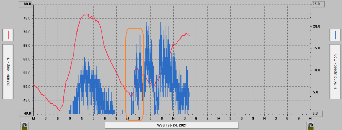
Still a relatively cool Santa Ana with Palm Springs barely reaching 70.0 points
-
Santa Anas kicked up in the middle of the night, immediately ratcheting up temperatures at my weather station. Highlighted here.
 0 points
 -
Season totals to-date are looking rather dismal, although there is still chance for even a semi-redemptive month ahead. With any precipitation through the next four days being very unlikely here, we can examine season totals up through February 28 of past rainy seasons and find ones that were similarly low or even lower. Downtown L.A. has only 4.39 inches to date. The "average" for them by the end of February is close to 10.5 inches. Quite a deficit. Temecula's season total right now is only 4.02 inches. Since 2000, only two rainy seasons were drier up to this point in Temecula: 2001-02 (2.85" through 2-28-2002) and 2006-07 (2.88" through 2-28-2007). Other similar totals were 4.32" by 2-28-2014, and 4.60" by 2-28-2018. My season total is lower (3.35") as I'm just far enough into the valley away from surrounding foothills and mountains that tend to boost rainfall totals for places like southern Temecula. Even a single good storm (1-2 inches or higher) or more in March or April could prevent the current season's totals from ending terribly low, but it's practically a roll of the dice. What happens (or doesn't) in March will be very important for our season.0 points
-
While cold for a 2 weeks stretch winter never really started and for all purposes snow play up here will be done after this weekend. On to next year.0 points
-
Enough said.
 0 points


This leaderboard is set to Vancouver/GMT-07:00