
Leaderboard


Popular Content
Showing content with the highest reputation on 04/16/21 in all areas
-
It is a winter wonderland here. There were 3-4" on top of my son's car, but in the grass it was probably a little over 2". Plenty of melting even in the dark. The streets were a slushy water combination. If this had happened during the day, I don't think anything would have accumulated. I would guess by late morning most will melt. If we officially finish with 3", we will be very close to 50" of snowfall for the season. My guess last night was we'd get 3", so I'm going to be pretty close.5 points
-
Holdrege at 6:50 am.
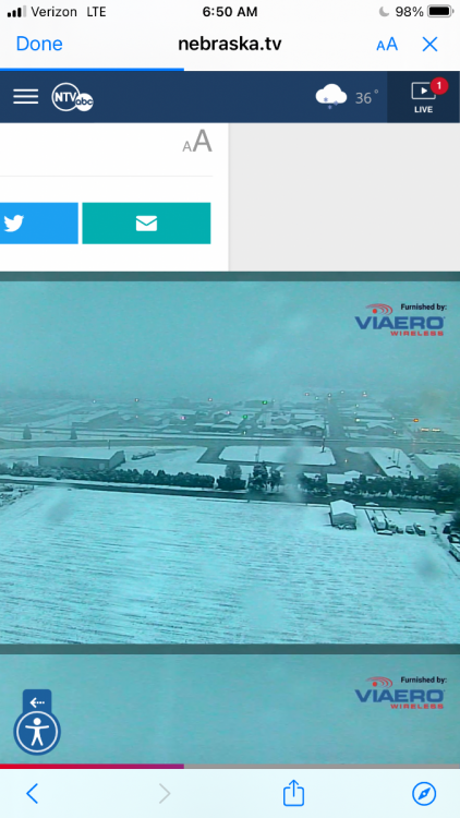 4 points
 -
I’m just south of the 6” circle in Central Nebraska2 points
-
Only a trace of rain here so far. I'm ready for some real spring weather and get my garden planted. Trees are beginning to leaf out so I'd rather not see much snow. Figures that mother nature would open up on us in mid April lol2 points
-
It's been cool lately, but I've been outdoors in full spring time mode recently (and real life has been keeping me extra busy of late). Yet here we are on 4/16 and I'm looking at model forecast snow maps. That's just wrong. @Clintonradar has looked impressive at times but I've only picked up 0.15" of rain today.2 points
-
Trees are flowering here. Most beautiful season in Marshall. Don't want to see it ruined by appreciable snow like 4/23/05. Worst climo when that happens bro2 points
-
With cloudy skies the overnight low here was held up to 39. Here is part of todays GRR NWS discussion. ” THIS AREA OF HIGH PRESSURE WILL BRING A CALM AND COOL NIGHT TO ALL OF THE AREA. NORMALLY WITH THE EXPECTED TEMPERATURES IN THE LOWER 30S FOR MOST, WE WOULD BE ISSUING A FROST ADVISORY. AS HAS BEEN MENTIONED MANY TIMES, LOCAL AGRICULTURAL EXPERTS ADVISE THAT IMPACTS WILL NOT HAPPEN UNTIL TEMPS GET DOWN INTO THE 20S FOR THE AREAS WHERE FRUIT TREES ARE STARTING TO BUD OUT. THE NORMALLY COLDER AREA OF INTERIOR CENTRAL LOWER WILL LIKELY GET DOWN INTO THE UPPER 20S, BUT THERE ARE NOT REALLY ANY FRUIT TREES UP THERE.” Having lived in Michigan for many, many years I never knew there was a line to the NE of Grand Rapids where there were no more fruit trees.2 points
-
I agree...GFS may not be cold enough...2 points
-
This is still several days out and accumulations will depend on timing. but a late season snow looking more possible.2 points
-
Good thing about the GFS in the longer range is that it's usually wrong and overdoes every cold push 9/10 times. THen it gets 1 right and people are like "wow the GFS nailed it". How many weeks did it take to get the GFS longer range right once this winter? 8 straight weeks it showed extreme cold air and finally the 9th week it happened? I'll take the Euro for the win.2 points
-
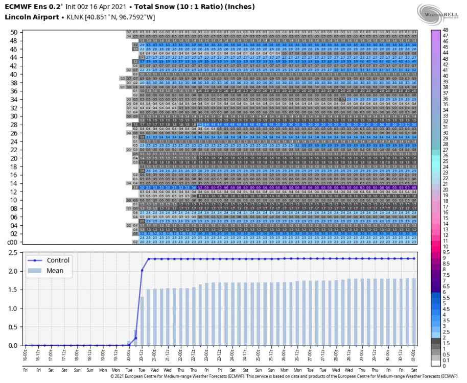
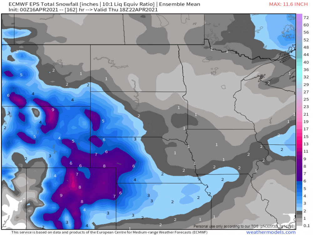
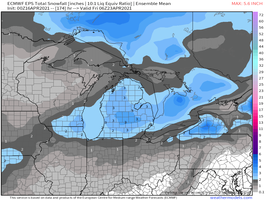
Euro 10:1 map It's looking like just a bit of white on the grass for me.1 point
-
Looks like we could be in for a slush fest.1 point
-
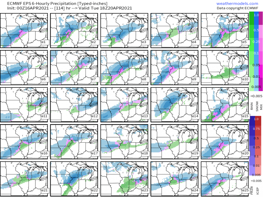
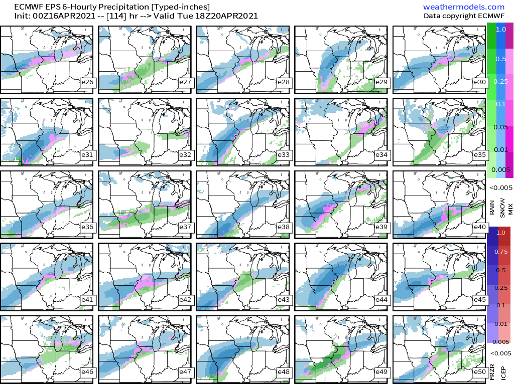
Every EPS member has accumulating snow Monday night/Tues morning for Lincoln....LOL what even
 1 point
 -
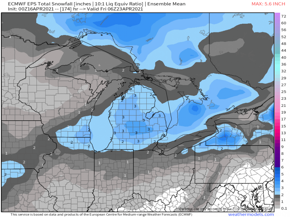
00z EPS members advertising a strong signal for an April version of a "front runner" cutting up into the lower lakes region...if this holds, it should push ORD past the 50" mark...I'm game...
 1 point
 -
The op Euro is also beginning to tease the return of spring warmth by day ten.1 point
-
Looking at the long term 12z GFS, it is one depressing run. Shot after shot of cold air. The jet stream is parked over the far southern United States, preventing any warm air from heading this way. Finally around day 9-10 the jet stream starts to buckle and eventually in the day 12ish time frame we start to see a warmup for a lot of the midwest from southern MN on south. But this is a long ways off, so definitely subject to change. We can only hope that is the start of the break to this awful weather pattern we are stuck in.1 point
-
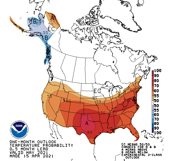
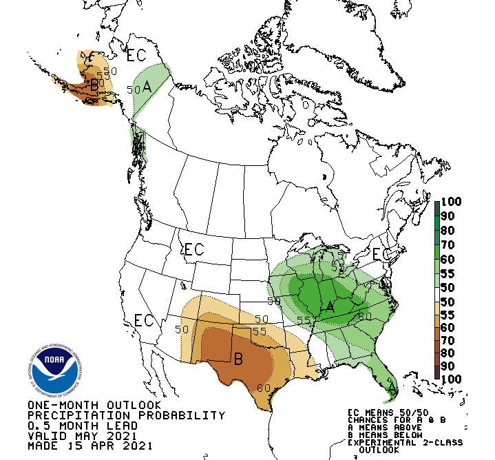
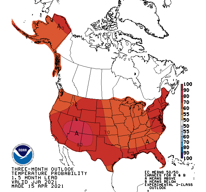
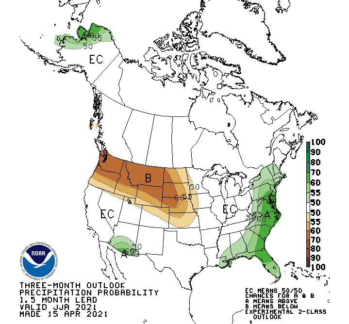
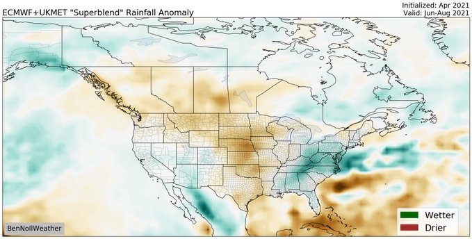
The CPC came out with their seasonal outlooks today and these are the maps for May. Since we don't have a summer thread yet, here are the summer maps...the signal is there for a central CONUS trough-like pattern and I'm really digging the SW Monsoon signal. Speaking of which, the ECMWF-UKMET superblend model also agree. The SW Monsoon is going to be a + signal for next year's cold season I believe. Late season hurricanes into the Baja??? The SE is going to see a lot of hurricane hits this year. Watch out Florida.
 1 point
 -
Same. This winter will really be one of the weirdest. Unremarkable but so very incredibly remarkable as well. Won't be forgotten for years to come and yet barely an extreme statistic in the entirety of it. Odd is right.1 point
-
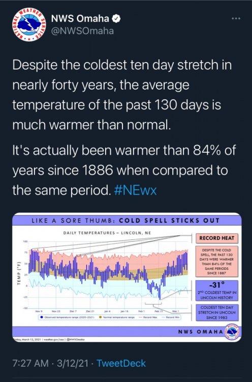
No suprise there. Dec and Jan torched despite respectable snowfall. Lincoln had no highs below 20 this winter outside of the 12 consecutive days (Feb 6-17). Now every day in March so far has been above average. Even with cooler weather coming, it's got to end up as some kind of record for difference in temps in back to back months. Odd winter for sure, but I would probably give it an A+/A.1 point
-
#SolarMin
 1 point
 -
Strat warming, Displaced Polar Vortex and the growing signs of a strong -NAO block...not a pretty combo to finish off the last weekend of April (except for the western Plains states). Last nights 00z EPS says Winter ain't over just yet and some snow may be flying around the MW/GL's region.
 0 points
 -
Well, this didn't stick. Last night's Euro replaced the warm surge with yet another blast of cold.0 points


This leaderboard is set to Vancouver/GMT-07:00