
Leaderboard


Popular Content
Showing content with the highest reputation on 04/17/21 in all areas
-
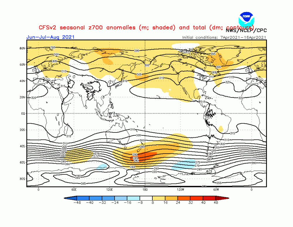
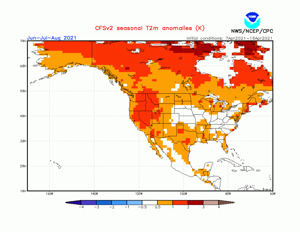
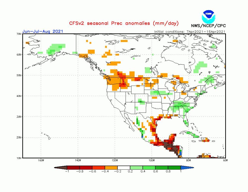
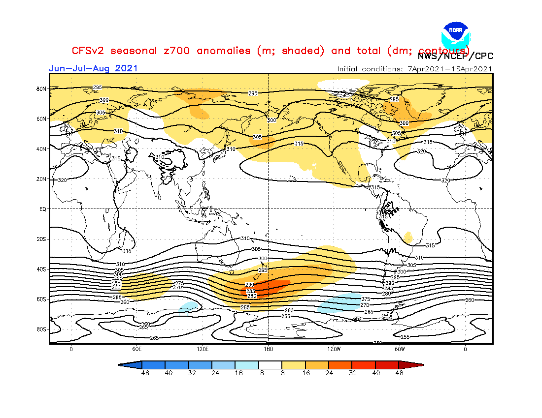
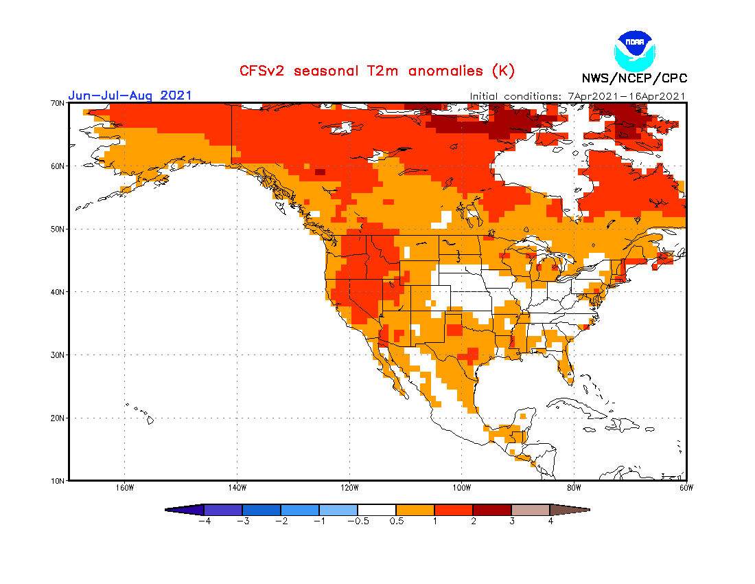
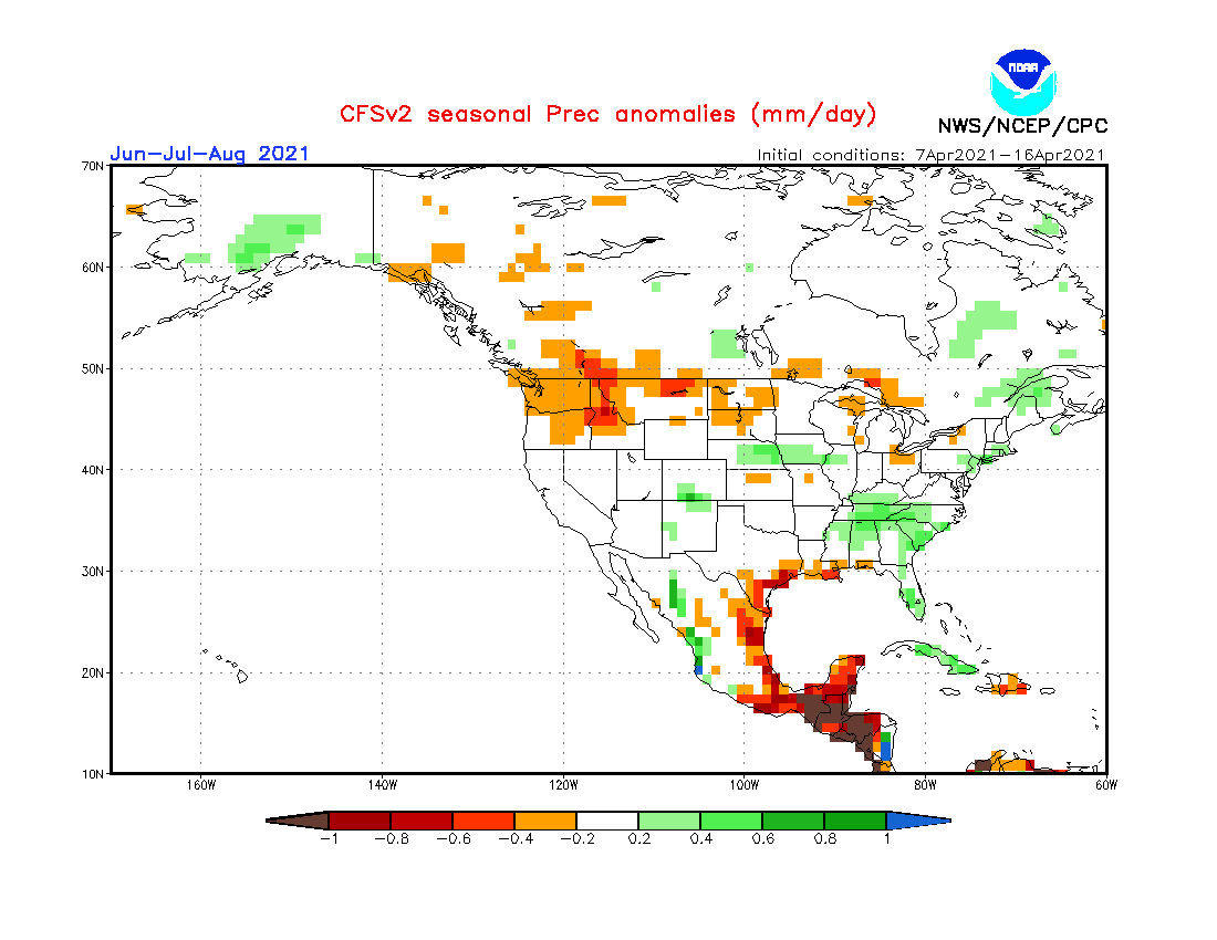
As we near the mid portion of Spring, the signals from mother nature are bi polar to say the least. It has been a really warm start overall since March but that has suddenly flipped around and some of you are feeling (or about to) the last signs of Ol' Man Winter for the season. Of course, depending on your location, that may change but generally speaking I can say with confidence that we are heading in the right direction once we close out April. By the time we enter met Summer, my prediction is for the Heat to build in from the SW into the heartland of the nation. My only concern is how strong does the blocking pattern form in NE Canada/Greenland that can influence the pattern across the MW/GL's region. Needless to say, this Summer will feature some unusual blocking formations and cut-off troughs IMHO. The west coast ridge will fire up early and often as it appears at this point. All the global models are signaling this to be a strong feature. Knowingly, the LRC, provides us with clues that the pattern will remain active. I know some outlets are all-in on a hot/dry summer across the corn belt/heartland, but I have this voice in my head saying " not so fast". How so?? Let's discuss... Blocking, Blocking, Blocking...I'm a Big Believer that this year and next will produce anomalous blocking patterns across the N Hemisphere. Coming out of what has been the lowest Solar Cycle in over 100 years, the jet stream is going to behave in unusual ways in the coming months. In terms of the Summer, could there be a benefit to this blocking? Yes, and I am already seeing the global models trending that way. The CFSv2 has been rock steady of late indicating lower heights over the eastern part of the CONUS. Notice that west-based Greenland Block (Strong LRC signal). Wet signal across the corn belt regions, SE and more importantly, the 4 corners.... IMO, this summer will be very active with regards to Severe Wx as we close in on June. Long-Lived MCS's/Derecho's? Could some members on here experience what IA did last year? I think the pattern could support this come June/July. Who will see bursts of Heat??? I don't, however, see long-lasting heat waves this summer but there will be some periods of heat, esp the Plains states and likely Upper MW.

 4 points
 -
The NAM is sticking with a farther nw track. My guess is it will trend southeast toward the other models.4 points
-
Today ended up being very pleasant. The temp over-performed a bit and reached the low 60s. The wind was fairly light and the sun was out. Sunday should be similar.3 points
-
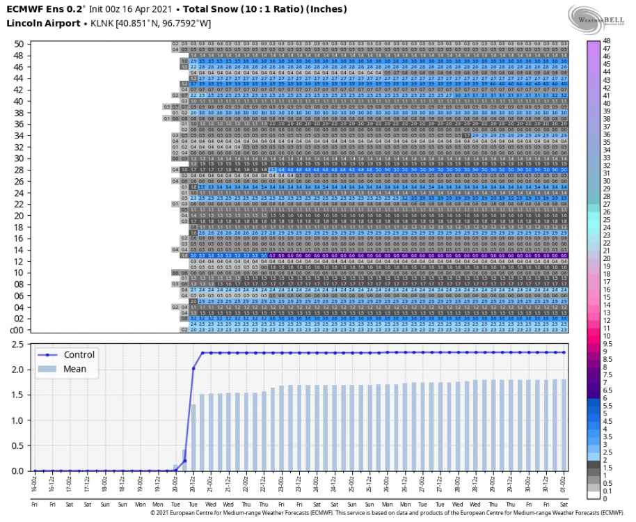
Fun fact: Our last measurable snowfall in TOP was Feb 17 (0.4") which would be over two months ago (62 days) from April 20 (our next chance).3 points
-
Snow chances automatically make me more active on here even if it's April Not that I'm a big severe person, but there hasn't been much to track the past few years anyways. Last year had a few good nighttime storms though. May 5, 2019 had that EF-2 tornado graze SW Lincoln, which was significant. Other than that, I think that's been the only TOR warning for the city of Lincoln since I moved here in 2017. You wouldn't think this is exactly "Tornado Alley"2 points
-
From EAX
 2 points
 -
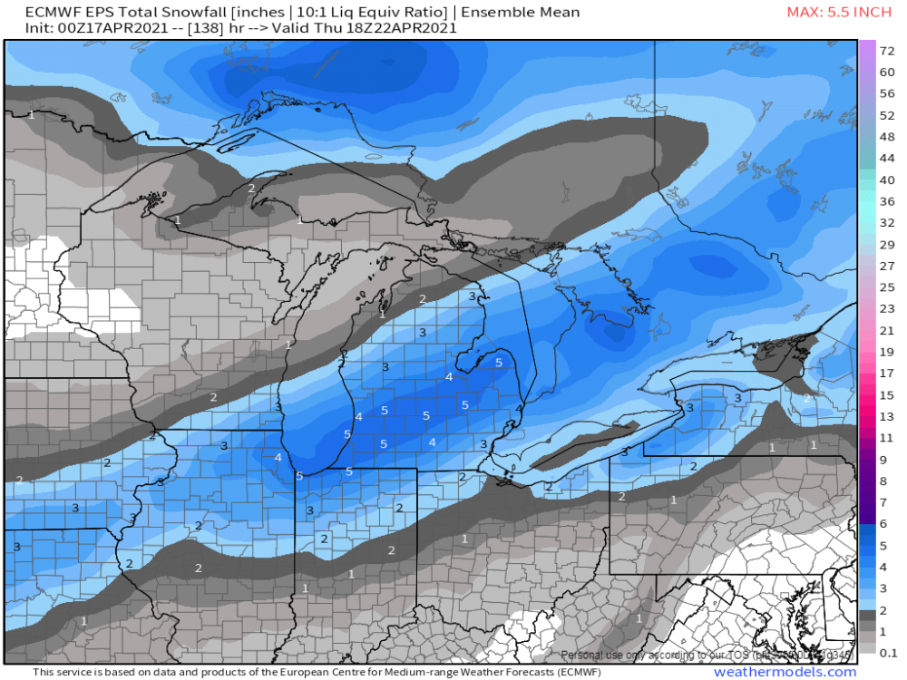
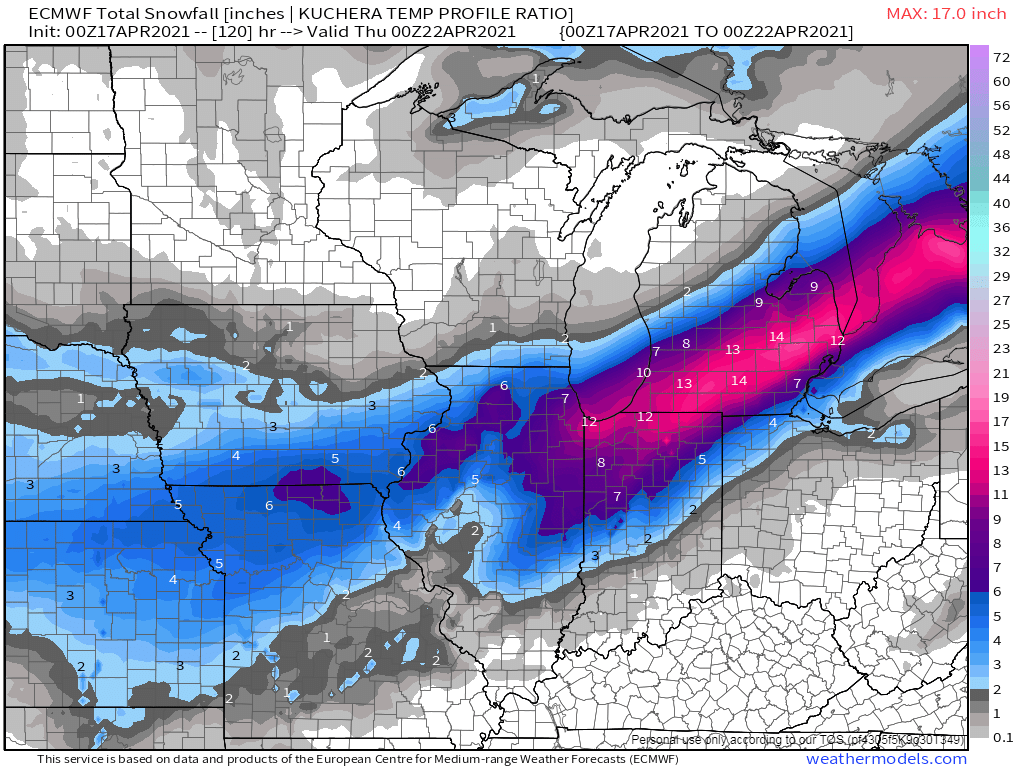
Here we are, mid/late April and we are tracking a potential formidable late season snowfall across the MW/GL's region. It will be April's version of a TX Panhandle cutter which will begin developing along a very potent cold front dropping down through the Great Plains on the infamous day of 4/20 (for various recreational reasons). Let's discuss... 00z Euro still holding onto the idea that MI will be the jack zone... @jaster220, I didn't realize that there is so much vegetation in bloom since I'm out here in AZ. This would be a bad scenario and I have to agree with you that it would be bad timing. In any event, the farther east you are the better chance of getting more snow bc it'll likely fall at night...otherwise, those who see snow falling during the day will prob just see slushy accumulations unless its ripping hard. 00z EPS...

 1 point
 -
00z NAM shifted south1 point
-
While we all keep praying for the inside slider that could bring some rain to the state, the reality is that California has nose dived into widespread and long term drought. Incredible as it sounds, the only remedies coming from Washington and Sacramento are those goofy ideas once thought to make a difference; put a brick in the toilet tank, replace the grass with cacti, etc. Helps a tiny bit but California needs big water-lots and lots of water. The ongoing infrastructure arguments in Washington should include requests for water infrastructure and research. The economy of the nation is highly dependent upon the success of the California economy. Even if you live in a waterlogged state, write or call your representative and urge them to do something big for water in California and the western states- an aqueduct, another dam and reservoir, desalinization plant? California probably has more scientists than any other state. Sadly, too many have eyes in the sky-spending billions to find out if there is water on the planet Mars. Finding more water for California would be a bettor effort.1 point
-
It looks like the heaviest snow is trending south of I-80. 12z Euro Kuchera is also somehow slightly higher totals than 10:1 lol. I can't imagine very good ratios out of this.1 point
-
Oh good, maybe we can make up the almost 3' snowfall deficit in GR this year...1 point
-
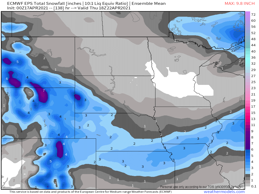
Yeah it is definitely going to be all about the timing all the models have heavy snow in my area but the GFS and the Euro have some of the snow falling while it's dark. The NAM has all of the snow falling in the daytime hours which would give me hardly any if any accumulation.1 point
-
I went ahead and started a storm thread for next weeks storm system... https://theweatherforums.com/index.php?/topic/7983-420-421-april-cutter/1 point
-
1 point
-
Cmon! What the hell is going on here? Give me spring! I have sand volleyball starting in a couple weeks. Unreal.1 point
-
Every EPS member has accumulating snow Monday night/Tues morning for Lincoln....LOL what even
 1 point
 -
It is a winter wonderland here. There were 3-4" on top of my son's car, but in the grass it was probably a little over 2". Plenty of melting even in the dark. The streets were a slushy water combination. If this had happened during the day, I don't think anything would have accumulated. I would guess by late morning most will melt. If we officially finish with 3", we will be very close to 50" of snowfall for the season. My guess last night was we'd get 3", so I'm going to be pretty close.1 point
-
Same here. Even if it's April. Ran across this the other day. -111C = -168F. 67,000' TS tops. Simply amazing. https://www.theweathernetwork.com/ca/news/article/super-cold-thunderstorm-sets-record-with-minus-111-celsius-cloud-temperature0 points
-
Monday and Tuesday are going to be cold. The Euro has us struggling to get above 40º both days.0 points


This leaderboard is set to Vancouver/GMT-07:00