
Leaderboard


Popular Content
Showing content with the highest reputation on 04/18/21 in all areas
-
Went down for a nap at 9am this morning and it was sunny and calm. Woke up at about noon and it was absolutely vomiting Buick sized flakes and the wind was howling.4 points
-
Here’s a preliminary look at the changes from the 30 year climate normals (1991-2020 minus 1981-2010). My part of se. Iowa hasn’t changed much temperature wise and maybe even dropped a hair if you look closely. It’s a little wetter though, which makes sense and I don’t mind.
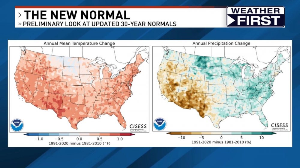
 4 points
 -
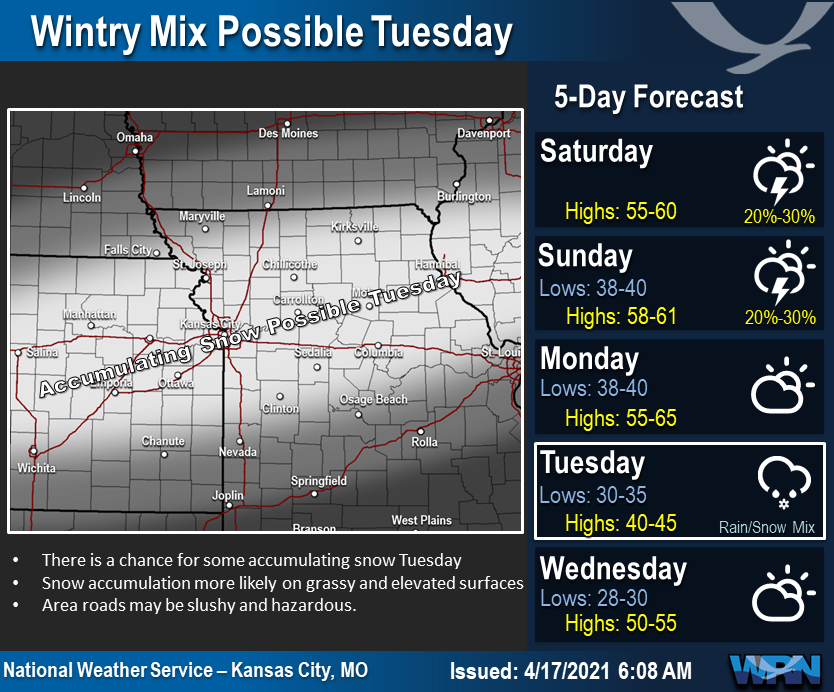
WWA issued for KC Winter Weather Advisory URGENT - WINTER WEATHER MESSAGE National Weather Service Kansas City/Pleasant Hill MO 259 PM CDT Sun Apr 18 2021 KSZ025-102>105-MOZ001>008-011>017-020>025-028>033-037>040-190400- /O.NEW.KEAX.WW.Y.0010.210420T0300Z-210420T1500Z/ Atchison KS-Doniphan-Leavenworth-Wyandotte-Johnson KS-Atchison MO- Nodaway-Worth-Gentry-Harrison-Mercer-Putnam-Schuyler-Holt-Andrew- De Kalb-Daviess-Grundy-Sullivan-Adair-Buchanan-Clinton-Caldwell- Livingston-Linn MO-Macon-Platte-Clay-Ray-Carroll-Chariton- Randolph-Jackson-Lafayette-Saline-Howard- Including the cities of Atchison, Wathena, Elwood, Troy, Highland, Fort Leavenworth, Leavenworth, Lansing, Kansas City Kansas, Overland Park, Stanley, Olathe, Shawnee, Lenexa, Tarkio, Rock Port, Fairfax, Maryville, Grant City, Albany, Stanberry, King City, Bethany, Princeton, Mercer, Unionville, Lancaster, Queen City, Greentop, Downing, Glenwood, Mound City, Oregon, Maitland, Forest City, Craig, Savannah, Country Club Villa, Maysville, Stewartsville, Osborn, Union Star, Clarksdale, Gallatin, Jamesport, Trenton, Milan, Green City, Kirksville, St. Joseph Airport, St. Joseph, Cameron, Plattsburg, Lathrop, Hamilton, Braymer, Polo, Breckenridge, Chillicothe, Brookfield, Marceline, Macon, La Plata, Parkville, Platte City, Riverside, Weatherby Lake, Weston, Gladstone, Liberty, Excelsior Springs, Richmond, Lawson, Carrollton, Salisbury, Brunswick, Keytesville, Moberly, Kansas City, Independence, Odessa, Higginsville, Lexington, Concordia, Marshall, Fayette, Glasgow, and New Franklin 259 PM CDT Sun Apr 18 2021 ...WINTER WEATHER ADVISORY IN EFFECT FROM 10 PM MONDAY TO 10 AM CDT TUESDAY... * WHAT...Snow expected. Total snow accumulations of 1 to 3 inches. * WHERE...Portions of east central and northeast Kansas and central, north central, northeast, northwest and west central Missouri. * WHEN...From 10 PM Monday to 10 AM CDT Tuesday. * IMPACTS...Plan on slippery road conditions. The hazardous conditions could impact the morning commute.3 points
-
Looks like the main show will pass to my south, but I just want 0.6" to hit 50" for the season, haha. Also might as well get snow if we're going to be stuck in the 30s all day tommorrow. Would probably break a daily record without a midnight high.2 points
-
The latest couple Euro runs are much warmer next week.2 points
-
The GFS is way south.2 points
-
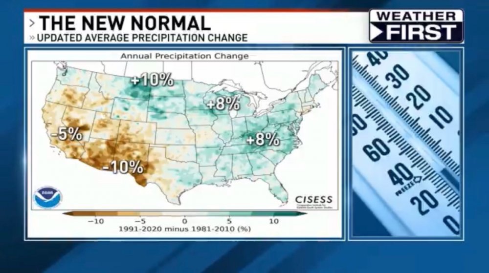
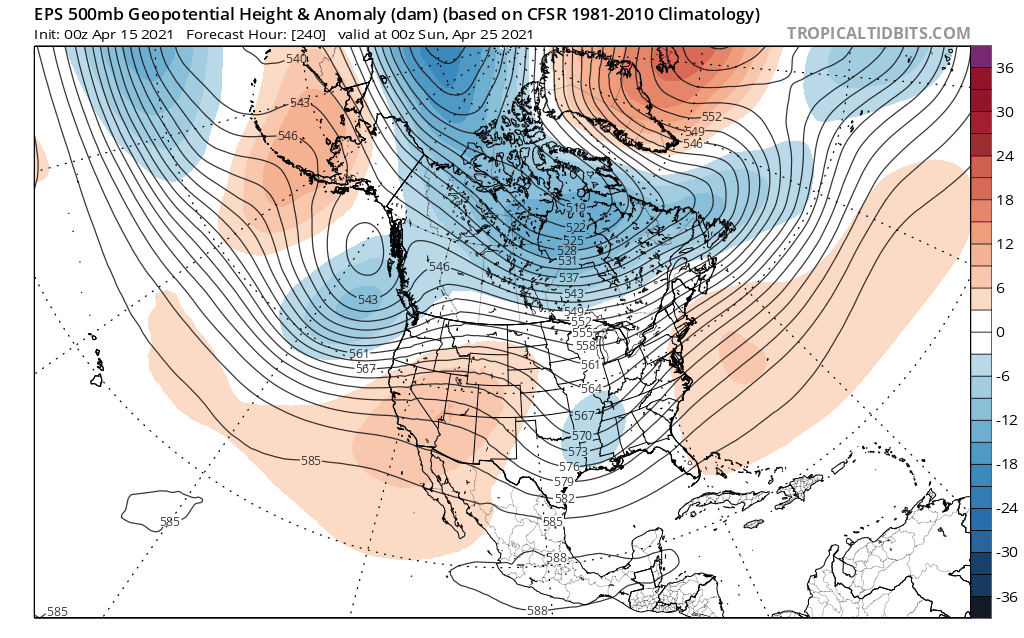
That is a fascinating map to see how much wetter things are getting up across the N Rockies/GL's/SE coast as well as the dryness that has transpired in the west/SW. It would be nice to have seen what a map of Canada looks like. I'd bet that it has cooled across the SW/C regions if you would take the map above and sorta see the cooler air up across the Dakotas/MT. You now, over the past 5 years or more, the N Rockies (esp MT) has seen tremendous amounts of snow in recent Winters and I've read that the glaciers up there are beginning to Grow. The national parks actually had to take down the signs which showed the glaciers were melting away...funny how nature turns things around in a positive light!2 points
-
The overnight low here was 29 and with clear skies there was some frost. At this time it is clear and 30. With some snow in the forecast it would not take much snow fall to set a new record for Tuesday as the record for April 20th at Grand Rapids is just 0.4" set in 1943. At Muskegon it is 0.3" set in 1953 at Kalamazoo it is just a trace and at Lansing it is 2.0" set in 1947. For Wednesday the record at Grand Rapids is 2.0" set in 1924 at Muskegon it is 0.5" set in 1912 at Kalamazoo it is 3.0" set in 1922 and at Lansing it is 3.0 set in 1868 yes that is 1868.2 points
-
Same here. Even if it's April. Ran across this the other day. -111C = -168F. 67,000' TS tops. Simply amazing. https://www.theweathernetwork.com/ca/news/article/super-cold-thunderstorm-sets-record-with-minus-111-celsius-cloud-temperature2 points
-
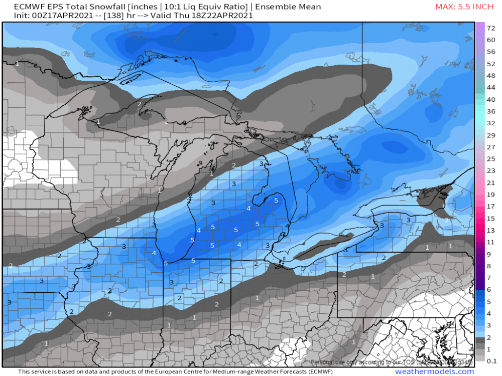
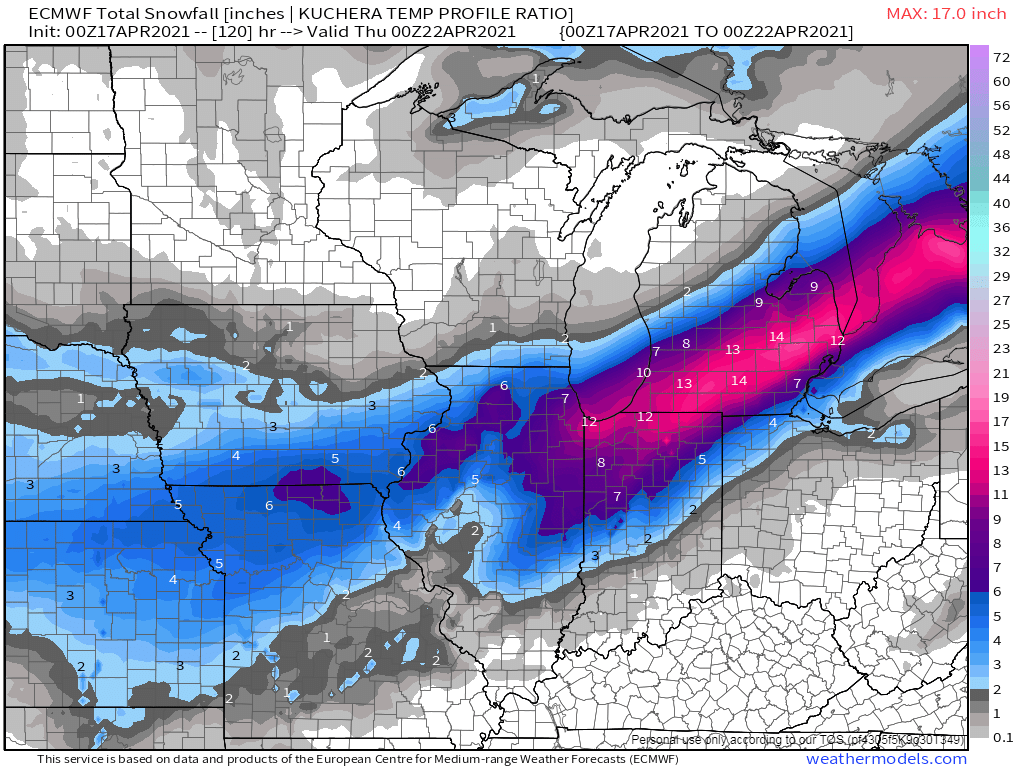
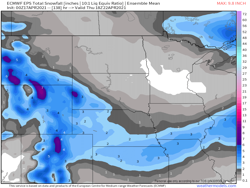
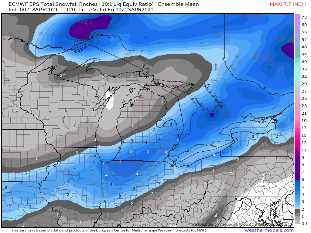
Here we are, mid/late April and we are tracking a potential formidable late season snowfall across the MW/GL's region. It will be April's version of a TX Panhandle cutter which will begin developing along a very potent cold front dropping down through the Great Plains on the infamous day of 4/20 (for various recreational reasons). Let's discuss... 00z Euro still holding onto the idea that MI will be the jack zone... @jaster220, I didn't realize that there is so much vegetation in bloom since I'm out here in AZ. This would be a bad scenario and I have to agree with you that it would be bad timing. In any event, the farther east you are the better chance of getting more snow bc it'll likely fall at night...otherwise, those who see snow falling during the day will prob just see slushy accumulations unless its ripping hard. 00z EPS...

 1 point
 -
00z HRRR... still much farther north than the global models.1 point
-
The trend for the snow is now more south and lighter. So it looks like the big issue for the week with be for a hard freeze. At this time it is nice and sunny and a pleasant 61 here at my house. I think this will be a good time to go out and cut the grass.1 point
-
12z Euro
 1 point
 -
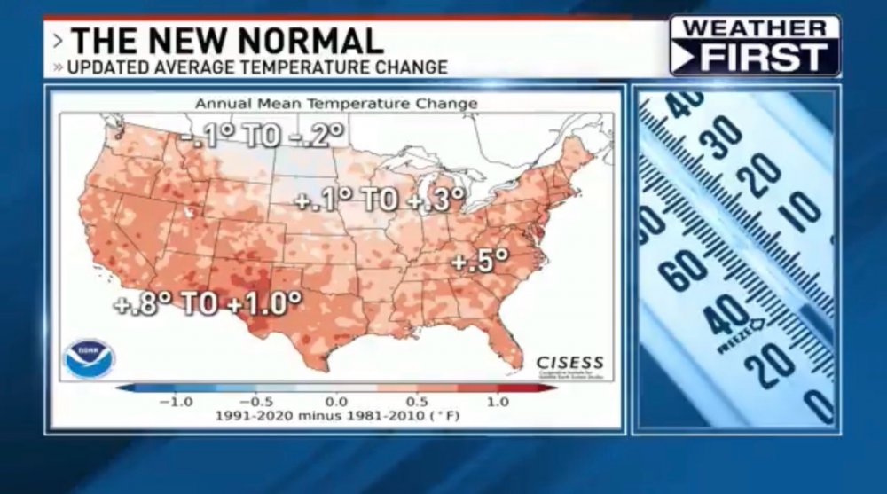
Be careful lumping eastern montana into the northern rockies. Eastern Montana is the same geography and climate as the western dakoatas and NE Wyoming...arid high plains. I am curious if the dropping of the 1988-89 drought has an effect on the averages. Does 2012 drought equally replace it? My Dad and uncles talk about how dry the 80s were in general for north dakota and nw minnesota, but I'm not sure if this is selective memory or not.1 point
-
00z Euro/EPS nudged SE a bit...
 1 point
 -
I'm seeing a late month Severe Wx outbreak across the Plains states and quite possibly into the eastern corn belt region. A powerful trough will come out of the Rockies (27th-30th) and plug into deep GOM moisture and pull up some early season heat and humidity. This could very well be a big ticket outbreak. Signs of an active pattern forthcoming as we roll into May. The power of the Greenland Block and Alaskan Ridge...impressive trends and unfortunately this means the warmth next weekend across the Plains is being delayed a day or two and looking less impressive. Quite the displaced Polar Vortex.
 1 point
 -
00z NAM shifted south1 point
-
Today ended up being very pleasant. The temp over-performed a bit and reached the low 60s. The wind was fairly light and the sun was out. Sunday should be similar.1 point
-
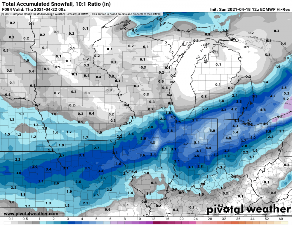
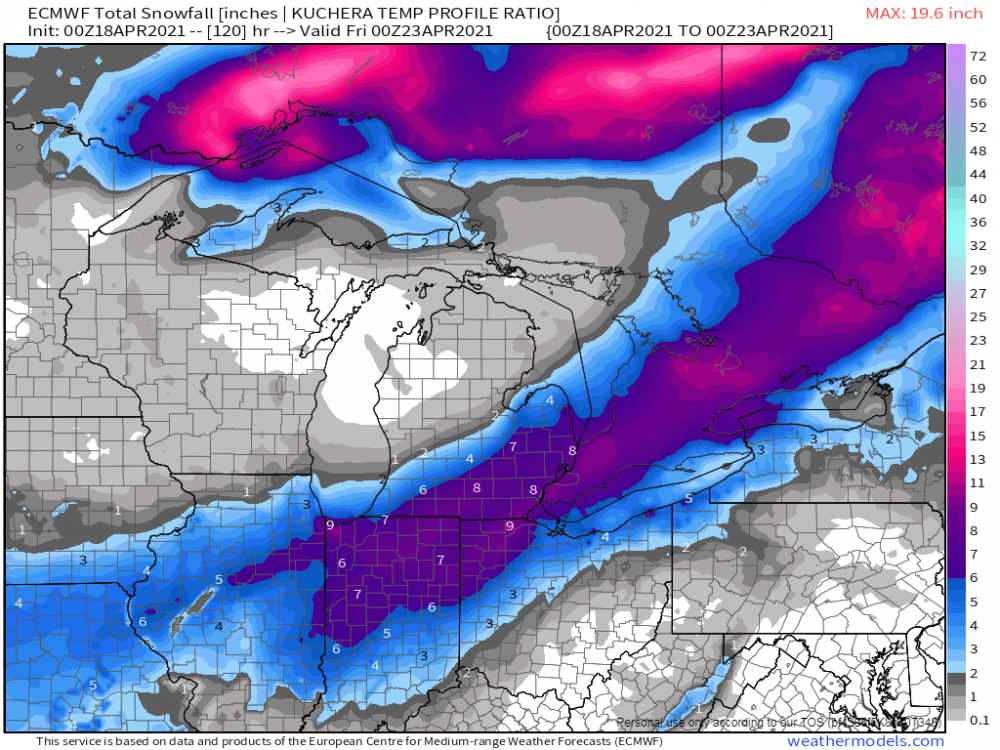
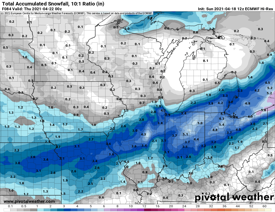
It looks like the heaviest snow is trending south of I-80. 12z Euro Kuchera is also somehow slightly higher totals than 10:1 lol. I can't imagine very good ratios out of this.1 point
-
The NAM is sticking with a farther nw track. My guess is it will trend southeast toward the other models.1 point
-
Fun fact: Our last measurable snowfall in TOP was Feb 17 (0.4") which would be over two months ago (62 days) from April 20 (our next chance).1 point
-
From EAX
 1 point
 -
Monday and Tuesday are going to be cold. The Euro has us struggling to get above 40º both days.0 points
-
Ended up with 8" overnight here. Looks like another quick-hitter on Monday could drop a few more inches.0 points


This leaderboard is set to Vancouver/GMT-07:00