
Leaderboard


Popular Content
Showing content with the highest reputation on 04/19/21 in all areas
-
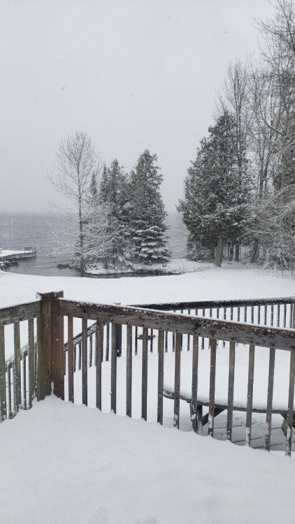
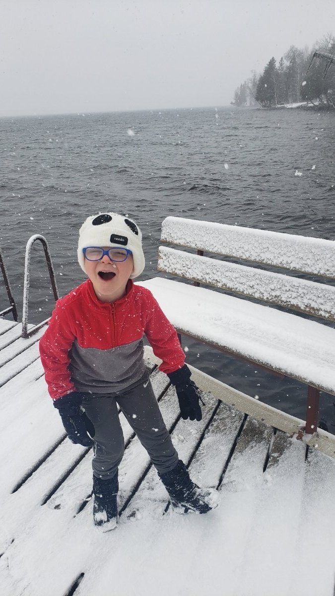
In da Yoop till move in day on May 7th. 3" down.


 4 points
 -
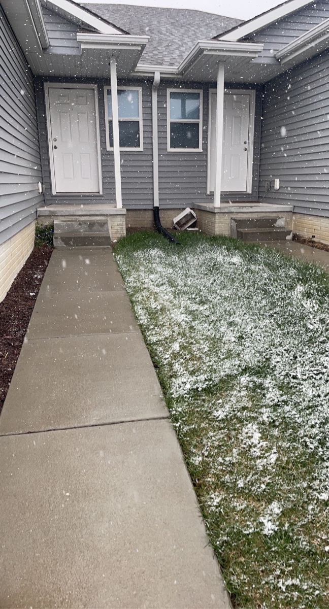
It’s trying (but struggling) to stick to grassy surfaces

 4 points
 -
April 19th folks lol! Too bad it’s the middle of the afternoon, this could probably accumulate at night. IMG_0336.MP44 points
-
There’s a rain/snow mix being reported in parts of central Iowa this morning. I don’t mind the snow mostly missing here. The main thing for me to worry about now is how hard it will freeze.3 points
-
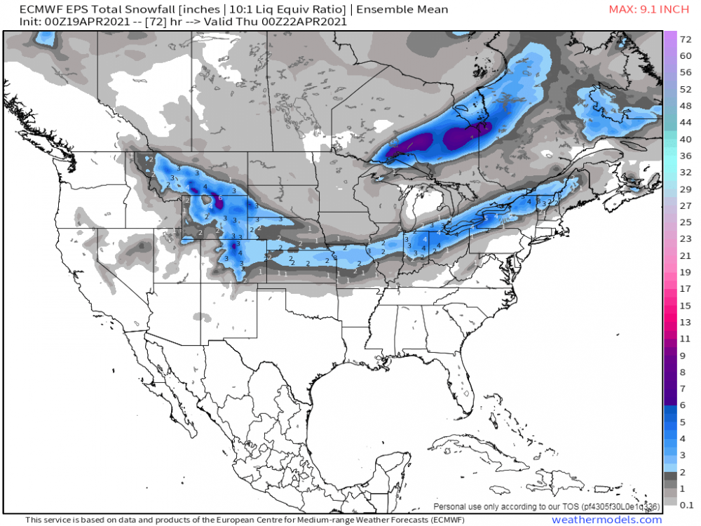
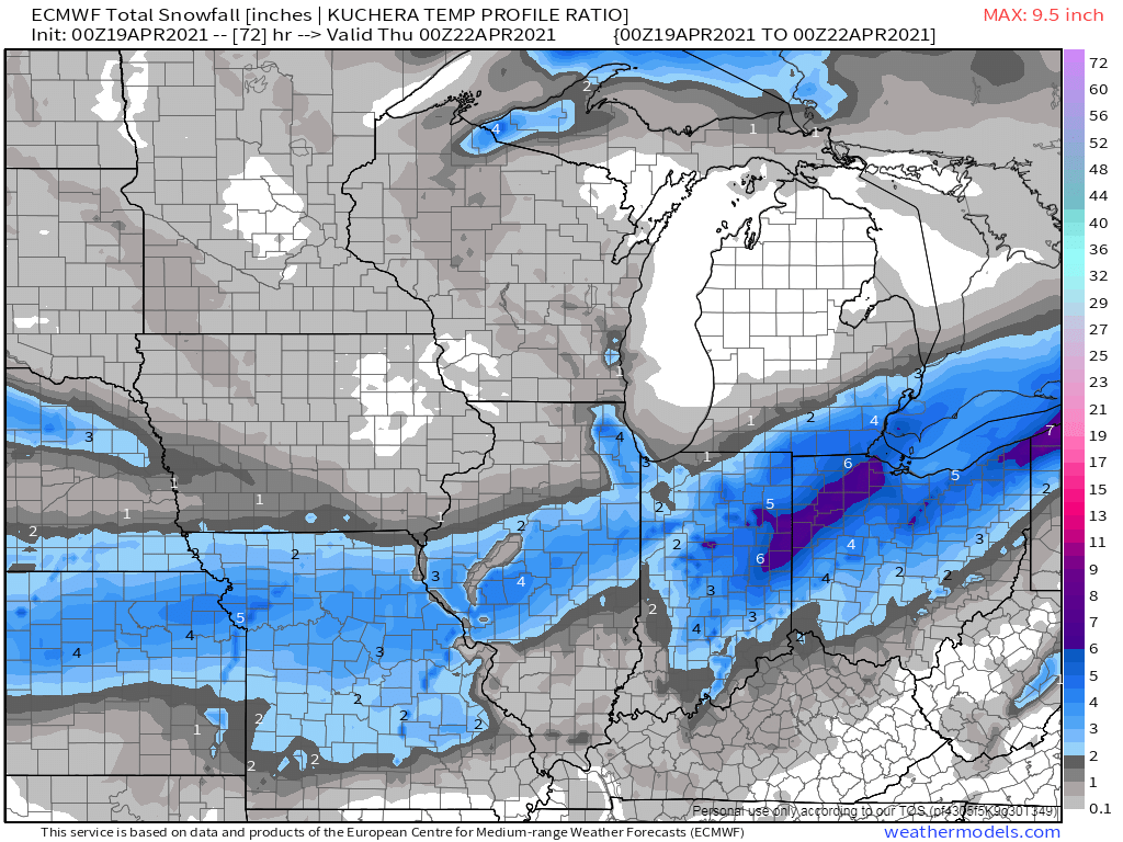
Quite the map for April 19th2 points
-
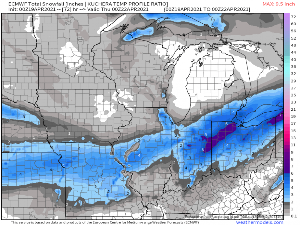
The global models won this battle. The NAM/HRRR blew it.2 points
-
Getting a few flakes right now. First time it's snowed in almost 2 months (2/21)!!2 points
-
The battle between the Euro/EPS and GFS/GEFS for this system...GFS/GEFS will win this one as it looks like a swing and a miss for Chicago (I'm sure there are plenty who are thrilled). The GFS always maintained a weaker and SE track across the Lower Lakes region but held steady near KC/MO.
 2 points
 -
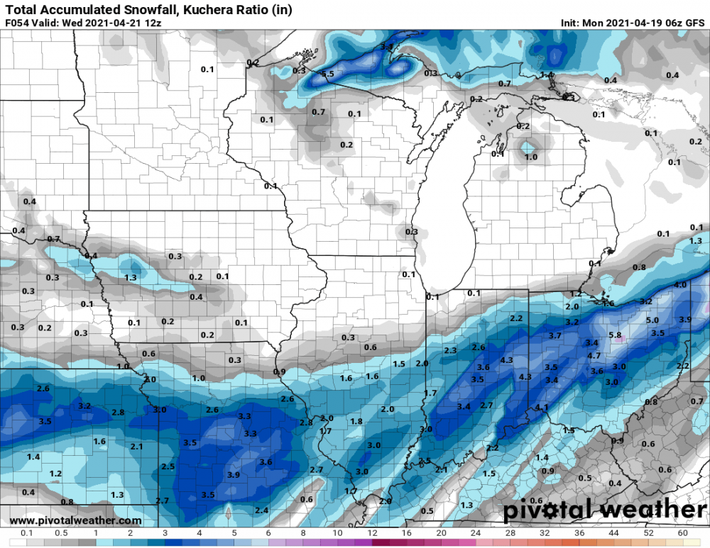
6z GFS remains mostly the same. For the KC area most of the snow falls between 4am and noon.
 2 points
 -
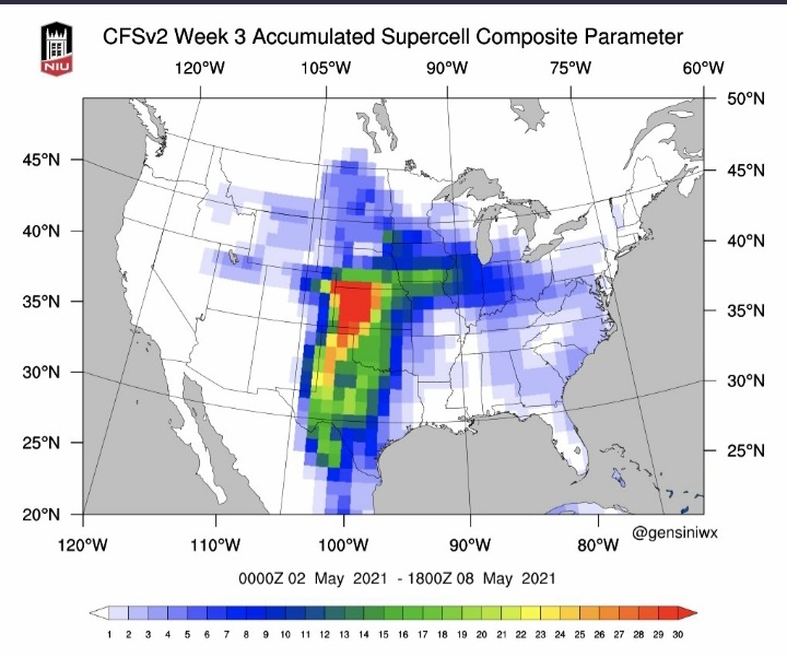
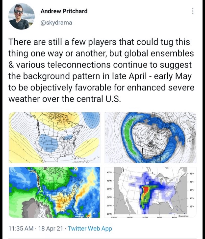
Pretty optimistic thoughts for severe weather chances really taking off by the beginning of May according to some of the veteran chasers


 2 points
 -
Went down for a nap at 9am this morning and it was sunny and calm. Woke up at about noon and it was absolutely vomiting Buick sized flakes and the wind was howling.2 points
-
And now DSM-
 2 points
 -
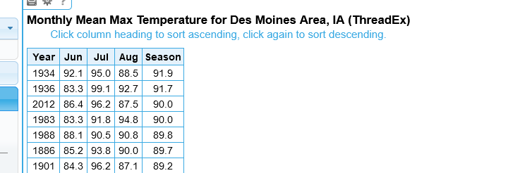
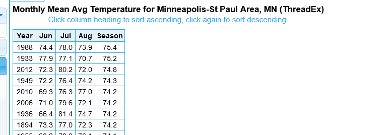
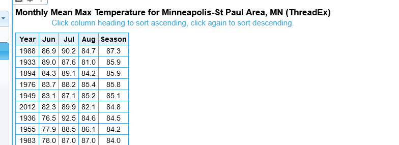
I lived in the Twin Cities in 1988. Was 15 yrs old. 2012 here in IA. I would say the 1988 drought was worse in MN compared to 2012 but that 2012 in IA was worse than 1988. I have data to back it up. (see below) Some recollections of the 1988- never seen grass as dead and brown so widespread. Water rationing (even house #'s got to water on even days of the month, Odd, on odd #'s )- but I grew up on lake and we pumped water, even with that we struggled to keep our lawn green and garden watered. Was at my grandma' / grandpa 60th wedding anniversary party on July 31st' 1988 near Faribault,MN, MSP got to 105F, I don't think it's even been close to as warm in MSP since, and was 107-108 at some reporting sites in S.MN. --*** the 99.1F AVG MAX temp for July of 36' for DSM is simply NEVER going to be touched *** First off Twin Cities-
 2 points
 -
The GFS is way south.2 points
-
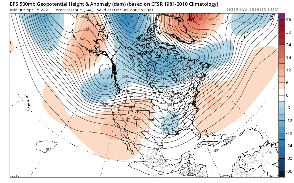
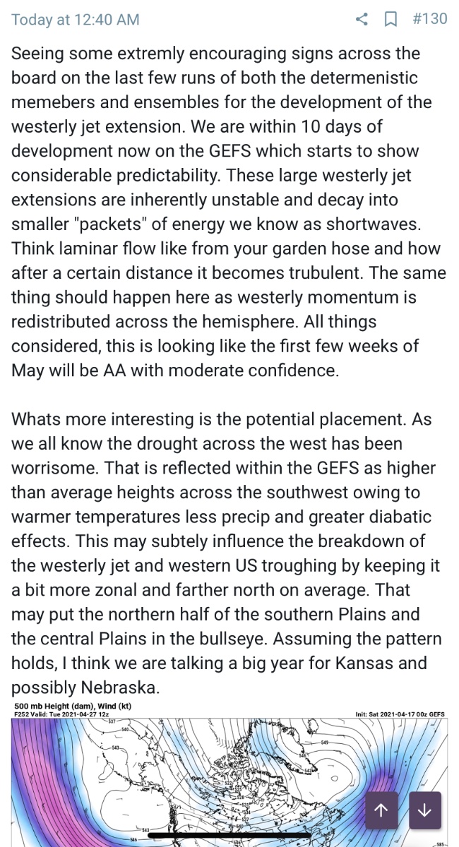
I'm seeing a late month Severe Wx outbreak across the Plains states and quite possibly into the eastern corn belt region. A powerful trough will come out of the Rockies (27th-30th) and plug into deep GOM moisture and pull up some early season heat and humidity. This could very well be a big ticket outbreak. Signs of an active pattern forthcoming as we roll into May. The power of the Greenland Block and Alaskan Ridge...impressive trends and unfortunately this means the warmth next weekend across the Plains is being delayed a day or two and looking less impressive. Quite the displaced Polar Vortex.
 2 points
 -
1-3 is in the forecast for mby followed by a hard freeze.
 1 point
 -
Snow has tapered off considerably now, just a very light dusting. 0.1" would be a generous number. It was quite the sight to see considering how late in the season it is and not a flake has fallen in nearly 2 months.1 point
-
Wet snowflakes are falling in Lincoln this afternoon. First time since 2/21 as well.1 point
-
ATTM NWS point forecast has 29° here for 2 nights. I hope the Euro is wrong! Currently it is raining lightly.1 point
-
The overnight low here at my house was 43 that looks to be the warmest low for a while. With highs in the upper 30’s forecasted for tomorrow and the low 40’s on Wednesday if that plays out we would be looking at some of the coldest maximums for both days. The record coldest maximum for April 22nd is 37 in 1914 and again in 1943 it was 38 in 2013. The record low for Wednesday morning is 22 set in 1953 all then 24 set in 2013 all other years were 25 or better. So April 20 and 21, 2021 could be one of the coldest for both dates.1 point
-
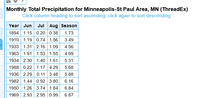
Precip for MSP- until AUG of 1988 it was neck and neck with 1894 as driest ever. I actually remember Bud Kraehling on WCCO comparing 88' at the time to 1894. RIP BUD- died at the ripe old age of 96 and did weather casts well into his 80s"
 1 point
 -
That is a fascinating map to see how much wetter things are getting up across the N Rockies/GL's/SE coast as well as the dryness that has transpired in the west/SW. It would be nice to have seen what a map of Canada looks like. I'd bet that it has cooled across the SW/C regions if you would take the map above and sorta see the cooler air up across the Dakotas/MT. You now, over the past 5 years or more, the N Rockies (esp MT) has seen tremendous amounts of snow in recent Winters and I've read that the glaciers up there are beginning to Grow. The national parks actually had to take down the signs which showed the glaciers were melting away...funny how nature turns things around in a positive light!1 point
-
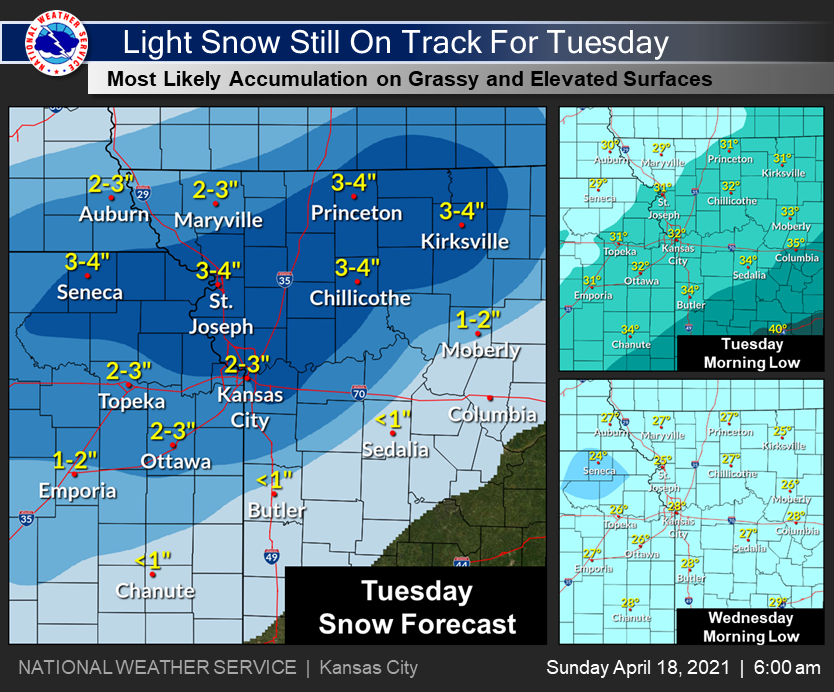
NWS KC targeting NW MO with highest accumulation.
 1 point
 -
Oh good, maybe we can make up the almost 3' snowfall deficit in GR this year...1 point
-
Fun fact: Our last measurable snowfall in TOP was Feb 17 (0.4") which would be over two months ago (62 days) from April 20 (our next chance).1 point
-
Only a trace of rain here so far. I'm ready for some real spring weather and get my garden planted. Trees are beginning to leaf out so I'd rather not see much snow. Figures that mother nature would open up on us in mid April lol1 point
-
It's been cool lately, but I've been outdoors in full spring time mode recently (and real life has been keeping me extra busy of late). Yet here we are on 4/16 and I'm looking at model forecast snow maps. That's just wrong. @Clintonradar has looked impressive at times but I've only picked up 0.15" of rain today.1 point
-
Ended up with 8" overnight here. Looks like another quick-hitter on Monday could drop a few more inches.1 point
-
1 point
-
It was absolutely weird. The snow for snowboarding was the best it's been in a very long time most of the year, but it also started later than any time in years and ended very early too. I easily lost a month of riding, which is a huge part of the season, but we had more powder days (for Wisconsin) than I can recall having in a single year in a very long time. This winter was weird, a lot of the things that make a winter suck for winter lovers was there, yet there was also a lot of good things. Personally it wasn't that good to me. The ski hill was absolutely slammed with people not having school, and November and March are usually the times when the regulars have the place to themselves, but we didn't really get that this year as season pass holder regulars. We basically jumped right into Christmas rush by opening on the 7th of Dec, then it all fell apart a little after President's Day, and March was easily half of what it normally is. I'd rather have the cold and a long season than warm and a lot of snow with a short season. I really hope next winter is better. For snowboarding and skiing, you just want it to get very cold as early as possible and to stay cold as long as possible. This pattern really sucks for me, it got warm enough to destroy the ski hills, now it looks like we'll get snow and cold for a while, preventing me from doing outside and lake stuff.1 point
-
The latest Euro has 27º here Wednesday morning and 24º Thursday morning. Plants will need to be covered well.0 points


This leaderboard is set to Vancouver/GMT-07:00