
Leaderboard


Popular Content
Showing content with the highest reputation on 04/27/21 in all areas
-
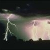
Don’t see this every day.. Occurred Friday in Lockett ,Texas Picture compliments of Capital Weather Gang7 points
-
Finally, I am on the receiving end of some much welcomed rainfall this morning. While its only about .10 or so it certainly has moistened up the ground and provided a fresh desert smell in the air. Birds are chirping and ecstatic to see the rain. The Heat is churning up later this week as a few 100's are showing up for the weekend. The "SW Sizzle" is going to be baking the deserts this weekend.5 points
-
Eppley airport hit 92 today. Just the 16th time in the month of April, a temperature of 92 or higher has been recorded at the airport in 151 years. Warmest April day since 4/15/02.4 points
-
Quite the temperature gradient over Iowa.
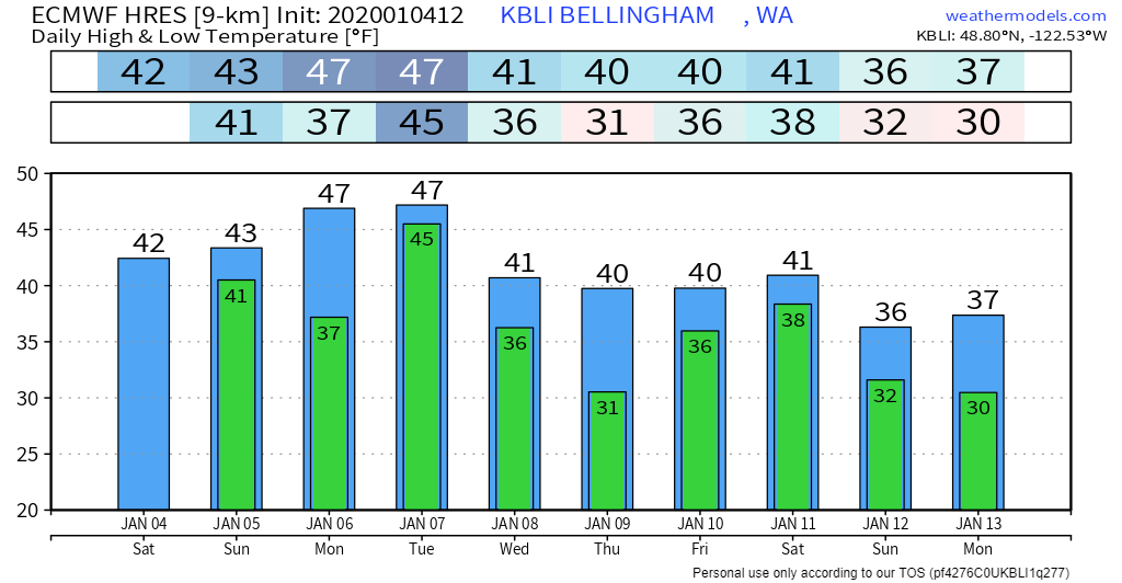 3 points
 -
Interesting this morning that the cold front has come through with a temp of 52 and north winds gusting to 20 MPH, it actually puts a chill in the air with cloudy skies. The roller coaster ride continues for the foreseeable future.3 points
-
The overnight run of the GFS does not shout a warm pattern as we get into May. Showing some nights in the 30's and highs 15-20 degrees below average. Hopefully it does not repeat this last 2.5 weeks in KC. Up until Sunday this past weekend, we had two straight weeks of well below average temps and some days just down right wintry. A windy 85 degrees yesterday. The warmth was nice after a very cold middle to late April. We did have quite a bit of freeze damage from last week. I dropped to 24 degrees in my part of KC. A lot of plants did have a moderate amount of new growth on them, so, a lot of the new leaf was burned badly. I have 55 Hydrangea plants on my property and they got destroyed. Now, I'm hopeful they will flush those leafs and form new ones. I'll know here soon..3 points
-
Had a high of 83° here today.3 points
-
One random downpour earlier this afternoon added an additional 0.12" to my total, while the nearby Murrieta station got 0.20" from it. It seems to have missed the rest of the valley entirely.1 point
-
Slight severe risk has nosed in to my area for this evening, also 2+inches of rainfall possible tonight and tomorrow.1 point
-
Fun fact. While it was hard for me to believe but on this date there have been a total of 8 years where it has gotten 80 or better and a total of 20 years where it has gotten to 75 or better. Now here comes the fun fact. Of the years it has gotten to 80 or better 5 of the summers that followed were cooler then average and 3 were average ( 1990, 1962, 1986, 1915 and 1970 cooler. 1899,1938 and 1914 average) but even more surprising is that of all of the years that it has gotten to 75 or better on this date (a total of 20 years) only one summer was warmer that average (1911) and only three more were average (1984,1952 and 1901) the other were cooler than average. So I guess the warmer it gets today the better chance of a cool or average summer. What a way to make a long range guess.1 point
-
Of course we will have to see just how warm it gets today in Grand Rapids. On this date there have been 8 years with highs in the 80's and a total of 20 years with highs of 75 or more. The last time it has gotten 75 or more on this date was in 2009 (76). Of note is that year July was one of the coolest on record here at Grand Rapids. It has not gotten to 80 or better here since 1990.1 point
-
With the ongoing drought in the SW US and last summer's "nonsoon", I feel that you are experiencing what is likely one of the most boring years that Phoenix has ever had in their history. I know that it is a dry climate, but this year has been downright dry! I am really hoping for a much more active monsoon this summer, not just for AZ, but for the SW in general, including portions of Socal as well.1 point
-
Made it up to 83 today and got my garden vegetables planted.1 point
-
It was 32 yesterday morning. Today it reached 88! Dewpoint all the way to 66. After so many days with highs in the 40s and 50s. A few 70s would of been nice1 point
-
Looks like 92.7 will be the high in my backyard1 point
-
I can believe that Lincoln averages an earlier date than KC, but not by almost a month. But behind MSP? No way lol1 point
-
Looks like our high will end up being 91. Humidity is a desert like 11%. Got the yard mowed. Didn’t sweat much with a breeze and low dew.1 point
-
90.7 so far in my backyard. The kids want me to get out the pool already1 point
-
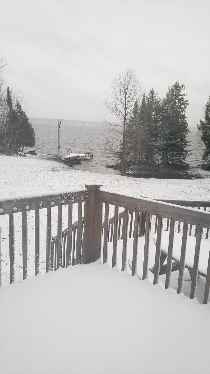
More snow in April than December
 1 point
 -
Notice how deep the marine layer was today. This view is from Palm Springs.
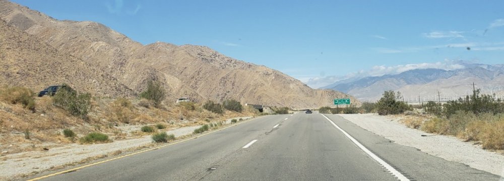 1 point
 -
I don't want to call it too soon but this storm looks like it was a major bust for nearly all of Southern California, with many areas having not received any measurable precipitation at all through this morning and any additional chances reduced to virtually zero. And to add insult to injury, later this week we have this to look forward to inland:0 points
-
It rained very lightly here in Orange last night but it wasn't enough to wet the ground or measure.0 points


This leaderboard is set to Vancouver/GMT-07:00