
Leaderboard


Popular Content
Showing content with the highest reputation on 05/22/21 in all areas
-
Hi, everybody. I have been lurking here for a while and finally joined. I recognize some of you from Mark Nelsen’s weather blog. I have been active on and off there for a long time. I love to complain about hot and dry weather. Yep, another one. Memorial Day week is not looking fun. Next Monday and Thursday hold some promise for meaningful rainfall. Here’s a depressing stat: PDX has not had more than .25’’ of rain in a day since Valentine’s Day. Hard to believe.10 points
-
I got only 0.06” yesterday and 0.07 today. In terms of severe storm and tornado warning counts for the DVN CWA this spring is comparable to 1986, 1987, 1992, & 1993 springs which also had very low counts. But I have fond memories of storms galore in summer of 1992 and 1993, but still maybe not a huge amount of severe wx. Spring of 1992 was extremely dry though and I’m sure in 1993 many farmers and folks along rivers were hoping to never see a repeat!! I recorded nearly 34” of rainfall from June through August of 1993 and my wettest month on record was July of 1992 with around 16”! I don’t have records or remember much of 1986 & ‘87. So this upcoming wetter pattern may just be the start of something? The weekend looks pretty good here. Surely we can get some decent storm action next week, hopefully. Farmers here are wishing for a dry week!5 points
-
Made it above freezing (barely) today after being below freezing for over 40 hours straight. 34/23 on the day and the snow is still on the trees. More record low highs and record lows set on the day. Truly remarkable for late May. Looks like maybe some more snow tonight before hopefully finally warming up into the 40's tomorrow with rain.3 points
-
3 points
-
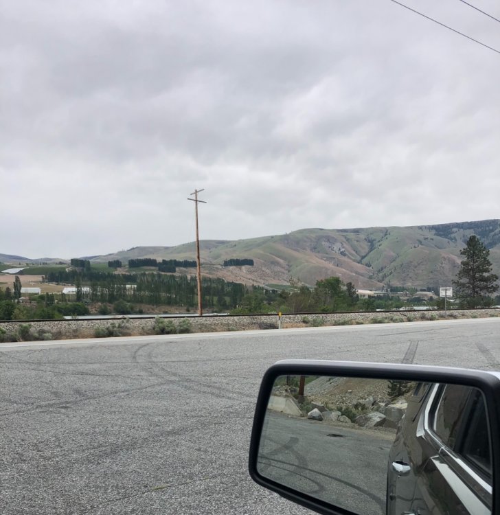
A little chilly and cloudy over here at Entiat...Tomorrow is supposed to be warmer luckily!
 3 points
 -
Very nice info! Ive only lived in Iowa since 2008. But the summer of 2010 was crazy wet. A friend ne of Ottumwa had over 60" for the yr and lake rathbun was absurdly over 70" 2008 was bad but seems most the river flooding originated further north? Its interesting to see 1993 started with low severe numbers. Ive barely heard any thunder here this yr. But plenty wet!!3 points
-
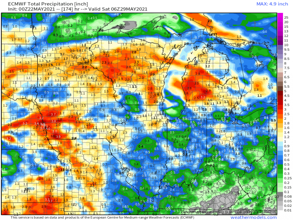
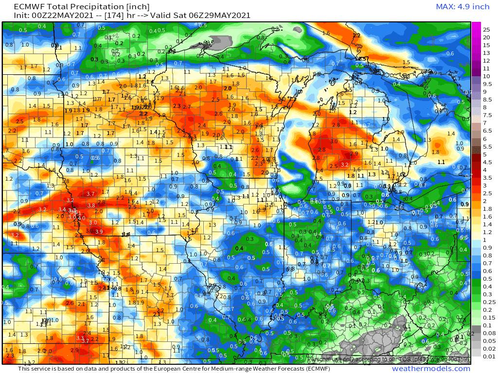
Thursday's Euro Weeklies run continues to illustrate a central CONUS deluge....the GOM will be fueling the atmosphere while CF's sweep through the majority of our Sub. I had an idea that by late May the severe wx threat would shift north and next week it is looking likely that our members in NE/IA will likely see there 1st severe storms.
 3 points
 -
Today was one of dampest days in this string of threats of rain daily. .26 my home. But .95 surprisingly at our shop east of Ottumwa. NWS had us a 20% for today yesterday evening forecast. Zero sun and still showering, Tropical. But high temp 73, not the 80s anticipated couple days back.2 points
-
For many days this weekend was looking like at least partly sunny with temps well into the 80s. Instead, it's more thick clouds with waves of mist and a temp near 70.2 points
-
It has already rained today so this is 8 consecutive days for TOP as well. Day 3 was .02 and day 7 was .01, but the other days have been generally around 0.50" or more. I was able to mow yesterday but everything was pretty soggy. More rain forecast for much of the upcoming week. Can you imagine if this was a winter snowy pattern? Yikes...lol2 points
-
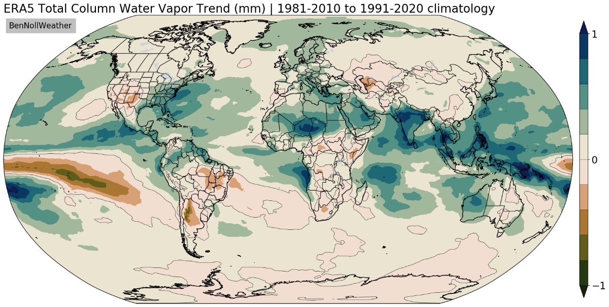
Looks like most of the world has seen an uptick in total column water vapor in the period of new climate normals. Of course, the SW US has dried out under the strengthening influence of the Hadley Cell descending branch. Also an interesting anomaly in the SE-Pacific.
 2 points
 -
This will be my 8th consecutive day of rain, the record is 10 back in 2017. Total rainfall over the 8 days is 2.76in. The last 4 days .2 or less has fallen each day.2 points
-
I woke up to a wet road and driveway. Went to the rain gauge and found out that a whopping 0.03"of rain fell. That brings the May total here at my house to 0.49" the official amount at GRR is 0.70 and to the west of me at Muskegon the official amount is 0.54" The overnight low both here and the airport was 65 and with cloudy skies it is now 68 here.2 points
-
While you guys a bit west are wishing for drier weather, folks over here are hoping for wetter weather! It appears that mother nature will attempt to balance things out around these parts but I'm getting more concerned for multi-day severe wx action days next week across the central ag belt. 0z Euro through next Sat...next Wed/Thu period could showcase an intense wave coming out of the Rockies producing the seasons first MCS or at the very least a widespread squall line???
 2 points
 -
Morning clouds and drizzle kept us a little cooler today than expected. 67 for the high.1 point
-
Colorado getting stormy. My brother moves there in mid-June. I'll probably scare him if I tell him Denver is in a Tornado Watch right now. lol
.gif.b16f77bd293a2b10cb84c6e475a5d740.gif) 1 point
1 point -
#SendingPrayers1 point
-
There’s some drizzle here this morning!1 point
-
Yeah DMX mentions possible severe and good rains next week.1 point
-
Finally have some good news on the tropical forcing front. Models have trended much lower in amplitude with the WPAC forcing (on aggregate). So the western ridge might be relatively short lived. We could be back in the “cool” phases 1-4 (for PNW in JJA, specifically) before the summer solstice. And the current (weak) troughy pattern has another week to run.
 1 point
 -
That is just insane! YUK!1 point
-
So refreshing to see some kind of impressive cold record again, in May no less.1 point
-
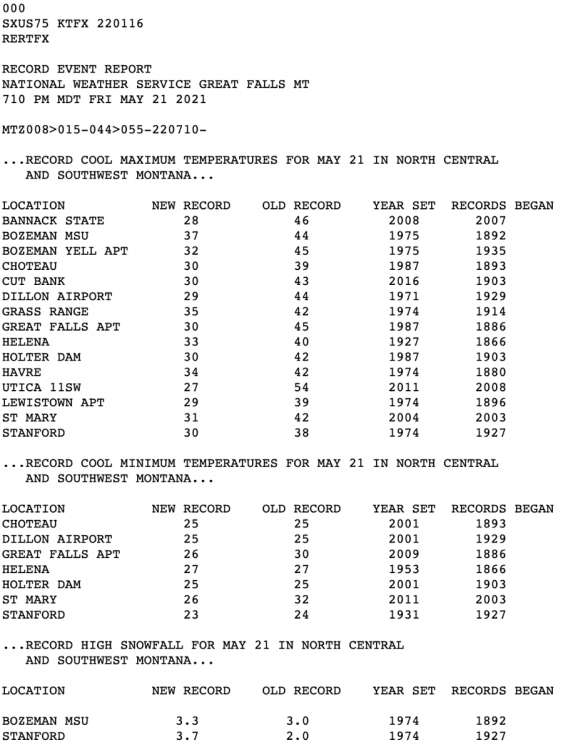
Still snowing here and 29 degrees as we approach 3pm...on May 21st. Just starting to realize the historical nature of this airmass. Latest high at or below freezing was set on May 1st 1954 at BZN and May 12th 1953 at Bozeman MSU. Airport is currently sitting right at 32F as is MSU. Would be really incredible to break that record by three weeks!1 point
-
10 years ago on May 22 2011, the American city of Joplin (Missouri) was badly hit by an EF-5 tornado. 158 dead and 1150 injured. Nearly 3 billion dollars in damage. What went wrong? Why so many deaths? With the help of a model we can find and analyze the causes. In the end you will also have some pictures of post-tornado Joplin and memorial. This video is a video presentation of Joris Dewolf (Belgian geographer and storm chaser). https://youtu.be/dJ57UrZ2eig1 point
-
66F and mostly sunny. Looks like another dry day so the kiddos are happy.0 points
-
Louder today. Can hear them from indoors for the first time. IMG_0584.mov0 points
-
We are waking up to more thick clouds today. There hasn't been morning sun since last week.0 points
-
Should be a total washout Memorial Day weekend... for the central BC coast.0 points
-
I wonder if we can go a decade without a sub-freezing high here? I don't think that feat has happened since the Medieval Warm Period. Now at like almost 1600 days since our last one. By far the longest stretch on record...fuckking depressing and I want to move my family so bad.0 points
-
The 32 degree high did indeed hold up at BZN. Breaks today's record low high by a whopping 13 degrees and will now go into the books as the latest freezing high on record (records go back to 1935). @BLI snowman Mark another historically cold airmass up!
 0 points
 -
PDX is still awaiting its first <60 high of the month. Toasty.0 points
-
Not so low key product placement. Partly to mostly cloudy with a low of 43 here. Shop Amazon.-1 points


This leaderboard is set to Vancouver/GMT-07:00