
Leaderboard


Popular Content
Showing content with the highest reputation on 08/26/21 in all areas
-
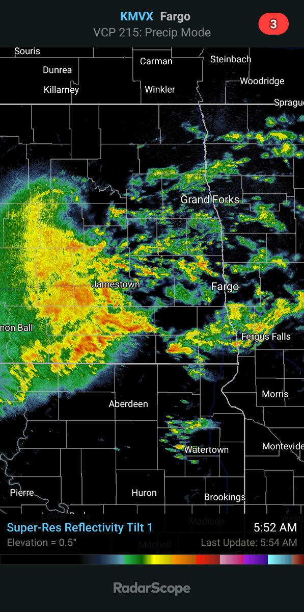
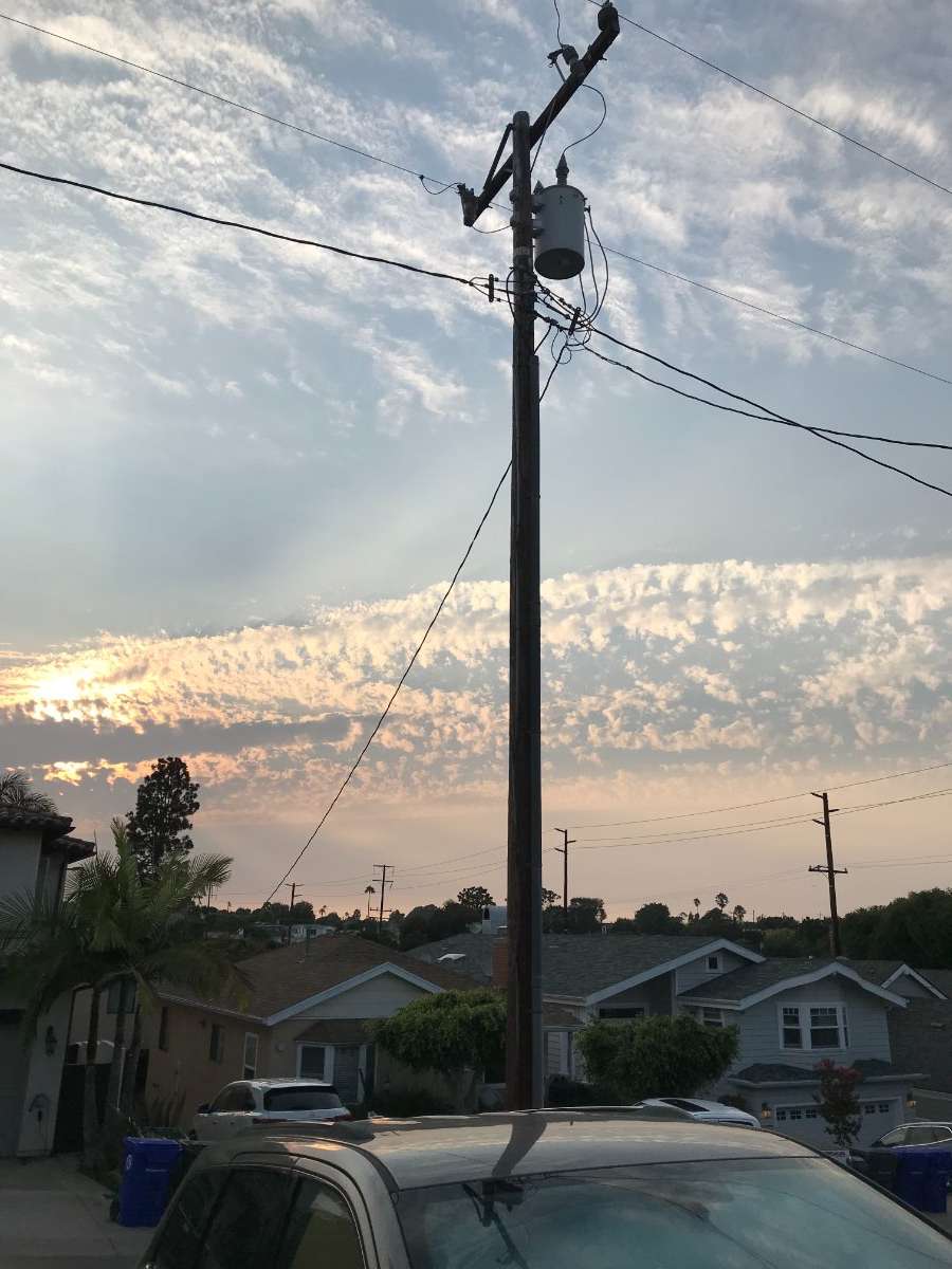
Looking at radar estimates, widespread 1" amounts in the Fargo area, 2"+ and still counting in the areas where the dried up Otter Tail River is. Keep whittling away.6 points
-
Exactly what the drought doctor ordered. Probably won't even hit 70 today, so I'm leaving my downwind windows open.
 5 points
 -
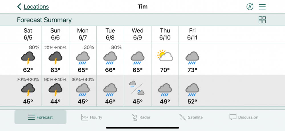
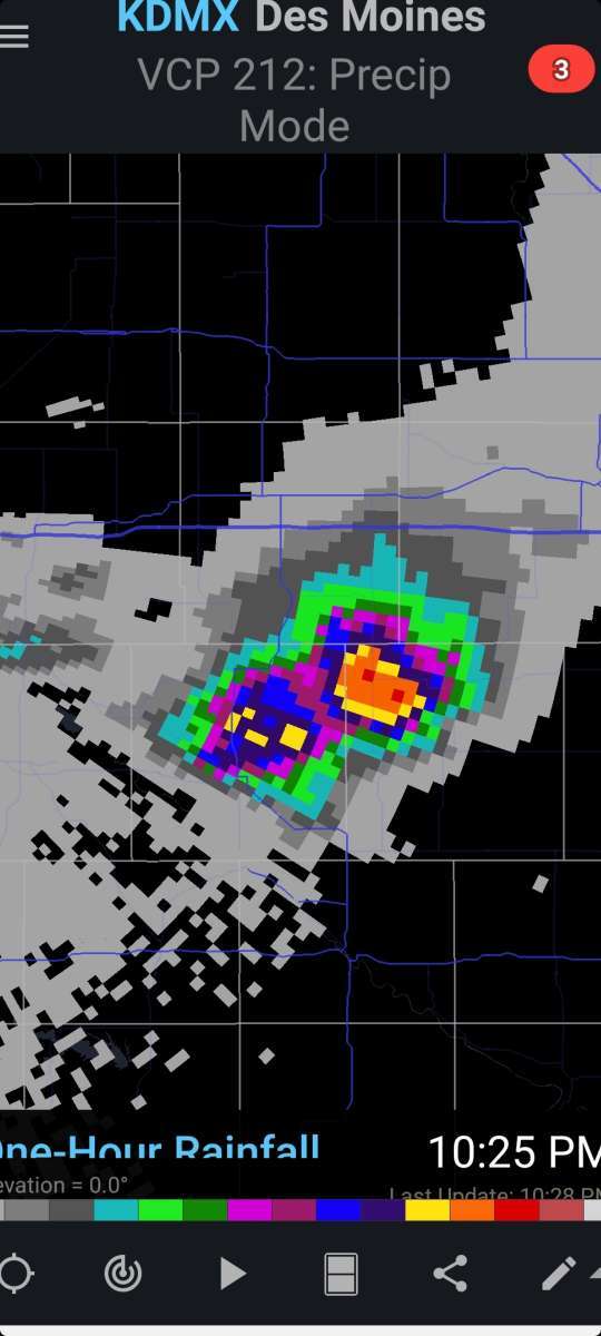
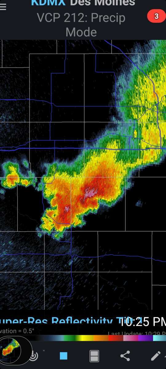
Flood Watch has been expanded in Iowa. It is pounding right now! Heavy thunderstorm4 points
-
I'm in a Flood Watch tonight for 3-5" with 6+ isolated. Wasn't expecting that4 points
-
Kuddo's to the GFS for staying pretty much steady on the track of our next Hurricane in the GOM. The Euro has caved towards the GFS track and targeting the LA area. Its still early in the game, but looking more and more likely that Houston may escape the worst of this storm. While we count down the remaining days of met Summer, how will we open met Autumn??? My, oh my, what a bountiful blocking pattern setting up across Canada/Greenland. Signal for the future?? The models are showing quite a fascinating temp gradient to open up Sept...battle of the seasons...a nearly 20-30F temp gradient if you believe the Euro in the extended. Who's ready for our 1st REAL Autumn cold front???? Your patience will be rewarded for our northern members who have been frying. #hoodiewx....dust off those sweaters and prepare for what will be some of the chilliest air of the early autumn season arriving during Labor Day weekend. Bon Fires, smore's, sausages and potato's in the fire??? Ahhh, I have these images in my mind of those type of nights up in the woods! #Septembrrr Chill is on Z way...

 4 points
 -
0.70" just in the last half hour. Had 0.20" earlier today3 points
-
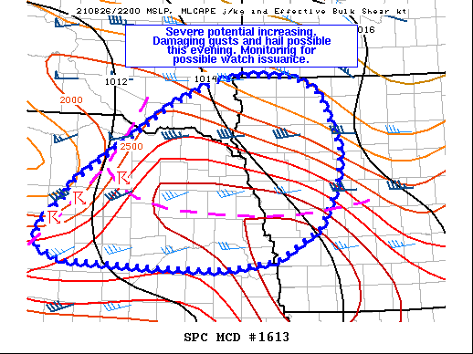
New SPC severe outlook3 points
-
Des Moines NWS talking 2-4" rain possible in my area along the highway 20 corridor with an enhanced risk of severe weather later today. Widespread damaging winds are the main threat. Could get quite interesting!3 points
-
Bring it on! I have more trees the storms can knock down that they didn't get yesterday. Lol3 points
-
The heavens opened up yet again yesterday around here in this soupy airmass. ORD hit a high of 94F and recorded 0.39" of rain while not a lot, but neighboring cities had flash flooding from nearly stationary storms that bubbled up along a lake breeze boundary dumping up to 1-4" of rain. More storms then blossomed right over my place around 10:00pm last night right as I was entering REM sleep. As that happened, a vicious lightning bolt struck about a block down the street and woke me up but then I was able to fall back asleep to the sound of rain falling. I dunno about you, but I love falling asleep to the sound of rain in the summer. http://mesonet.agron.iastate.edu/current/mcview.phtml?prod=lotrad&java=script&mode=archive&frames=50&interval=10&year=2021&month=8&day=25&hour=17&minute=03 points
-
It all congealed into one big cell! Man I’ld love to be under that downpour!2 points
-
Models dont show anything but
 2 points
 -
Getting a very heavy shower. The road is flooding out. I will post a rain fall amount when the rain stops.2 points
-
Kinda windy with some thunder and light rain just starting. Gonna be irritated if this ends up being weak and then kills off the strong storm potential later.2 points
-
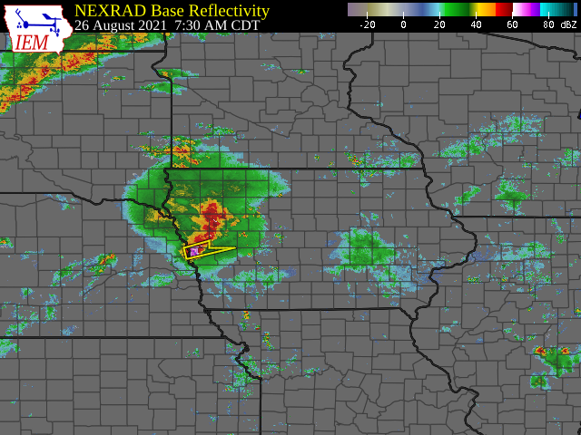
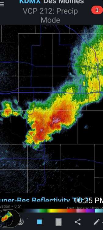
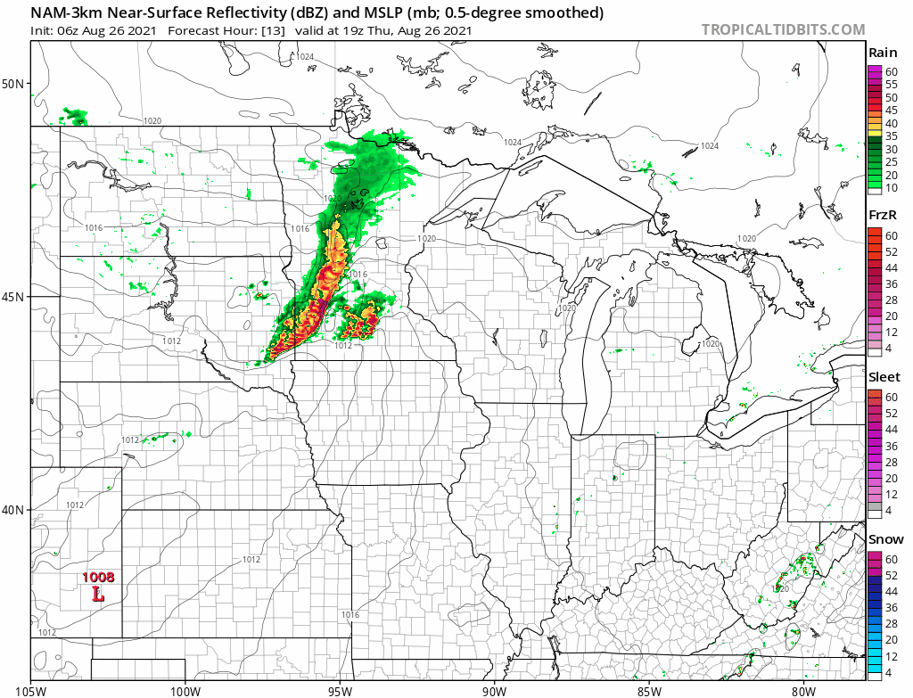
The CAMs are, once again, struggling to even see the MCS in western Iowa. A new SPC discussion says... The airmass downstream is not overly favorable at the moment for this activity to maintain itself, as a fair amount of convective inhibition is in place across IA per recent mesoanalysis estimates.2 points
-
Kinda reminiscent of 8-10-20. Derecho coming ?
 2 points
 -
I’m hoping for some active storms heading into eastern Iowa later today.
 2 points
 -
Ive been watching that closely. Might catch Ottumwa after all. Torrents of rain with it. 3 to 6 inches per hour.

 1 point
 -
More non forecasted rain. Large complex of storms rolling in. Feels like a tropical rain storm.1 point
-
Cams did very poorly last night and today. I wouldn't give up yet1 point
-
Wow, It did not rain for all that long but it came down very hard. I just checked and there is 0.83" in my rain gauge. And there is now a lot of thunder off to my east. It did drop the temperature down to 77 and it now feel nice out. Will go for my walk in a little while.1 point
-
Currently just exited the first round of storms. Looking like it is going to be a nice and wet stretch here (finally). Currently getting some unexpected sun as well as intense wildfire smoke. Models seem to disagree on timing a bit, but we look to score some nice storms with a warm front in place and an LLJ that starts screaming heading into the night. Maybe after this stretch I won't be able to walk across the Mississippi and Rum rivers... Hoping this also signals the end of being baked to a crisp!1 point
-
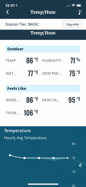
Sunny, hot, and humid. Temp is 96 and heat index is 106.1 point
-
Nice rumbles of thunder with a steady rain. I think its gonna remain too cloudy and cool for any severe stuff but maybe we can score some old fashioned tstorms with good rain. Nice to see some development behind this MCS.1 point
-
Storms are kind of bubbling up on the back end again north of Des Moines. The old MCS decayed soon enough that storms could reorganize this afternoon, although there are some clouds around, but not very thick so far. All that is left of the weak outflow are some wavy clouds just east of here.1 point
-
I'll be honest, i thought the exact same thing when i looked at radar.1 point
-
I'll be ready over here in Waterloo, man!!1 point
-
http://www.alertwildfire.org is a good site to see webcam footage of active fires, as these cams have been positioned in order for people to report fires. Most of the cams are in CA, but there are a few in Oregon, Nevada, and Washington as well.1 point
-
Looking like a good bet it will be IA's turn later today...
 1 point
 -
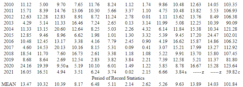
Still sitting at 8.76" on the year. These are some desert numbers.1 point
-
A tropical system will be coming up towards Baja and maybe the southwest in about a week. Ironically it will have the same name 'Nora' as another system with a very similar track from 1997 that caused a lot of problems down here. SSTAs are above normal so I suppose its possible.
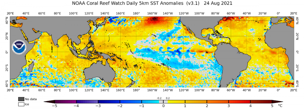 1 point
 -
Currently a tornado warned storm just se. of the Quad Cities.
 1 point
 -
I agree with him and I think 3 and maybe 4 major hurricanes are possible in the Gulf and I expect at 2 or 3 of them to make landfall in Louisiana based on the LRC. The gulf coast in Florida being the other.1 point
-
I saw a post on Twitter from a hurricane guy showing the upper level patterns and that it’s showing a potential hyper active hurricane threat coming up towards the 1st of September.1 point
-
Not sure where these came from, but I’ll take it. You can see how much shorter the days are getting. AquariusRadar, I’m still stunned that more effort hasn’t been put into rain catchment and absorbent pavement in cities in the monsoon zone. Just one stray shower can make a difference. Do people just not want tanks on their roofs? Plus porous pavement would make flash floods less likely, and help recharge aquifers. The idea has been thrown around out here too to keep winter storm water from being wasted to the ocean, but it hasn’t gotten any serious momentum.
 1 point
 -
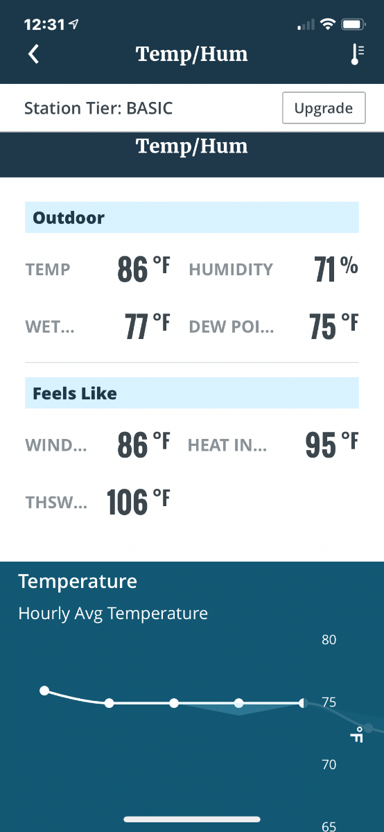
It just never ends. Really done with this summer. This is as of 12:30 pm.
 0 points


This leaderboard is set to Vancouver/GMT-07:00