
Leaderboard


Popular Content
Showing content with the highest reputation on 08/29/21 in all areas
-
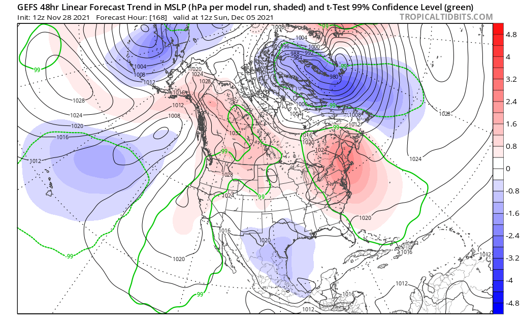
The good ol' Hudson Bay Block is trending stronger in the medium range which is "pressing" the front over the big holiday weekend farther south now. Boy, these daytime high temps for the central Plains/MW/Upper MW look super. Upper 60's for the Northwoods next Sunday??? #Fall #BonfireWx
 6 points
 -
So happy to hear that the "desert" climate you've been experiencing this summer is likely history for the rest of this year! On the topic of history, Ida is about to make history and hours away from slamming into LA as a very powerful CAT 4 with winds now at 145 mph. This storm is going to cause tremendous coastal and inland flooding along with immense storm surge. Nothing worse than a rapidly deepening storm as it approaches while slowing down. I feel for those who are in the path of this storm. Prayers to all.4 points
-
11:55 am CDT #Ida made landfall as an extremely dangerous category 4 hurricane near Port Fourchon, Louisiana https://twitter.com/NHC_Atlantic/status/1432024656932794373
 3 points
 -
I was asleep, but overnight was the first widespread downpour in like forever. 1.12" at the airport.3 points
-
I got 0.55” this early morning. Lots of reports over 2.5” north and west. Corn now needs dry weather for the final maturation stage. Also should not be putting off much evapotranspiration anymore. One day of cooler today that back to warm for the week. Hopefully Friday onward we flip to a Fall pattern.3 points
-
@snowstorm83and LNK/OMA crew got hit pretty good overnight...and of course @CentralNebWeather where its been tropical of late. @gabel23, how are you doing out there? Is your garden doing good this year? http://mesonet.agron.iastate.edu/current/mcview.phtml?prod=comprad&java=script&mode=archive&frames=75&interval=10&year=2021&month=8&day=28&hour=19&minute=403 points
-
Another thunderstorm moving through. We've made up the deficit quite nicely with all these rounds of rain over the past couple of days.3 points
-
Been a crazy year @Tom. Rain totals this month is sitting at just over 7" with another 2-3" in the forecast for tomorrow into tomorrow night. Last night we had a crazy amount of CG and the rain came down in buckets. Garden is out of conrol! Wife put up 14 quarts of chili and spaghetti base today and I still have 6 beer flats of tomatoes sitting in the wind! We also canned our Colorado peaches tonight so it has been a crazy sunday. My total precipitation since January (34.05") is well over what I average in a given year!2 points
-
153mph wind gust at Port Fourchon, LA where it made landfall. Wild video footage coming in from Louisiana2 points
-
Ida’s going to hit the beach in about an hour just west of NOLA as a Cat 5 ( I’m hearing Cat 4 too but it’s on the line) Pressure 933mb wave height 14-15’ Wind is 150 mph, gusts to 185 mph Her strengthening should be no surprise as the Gulf waters are so warm. 87-88*. They’re talking echoes of Katrina and hopefully all the lessons learned will assist in moderating this storm. The pumps and wall were improved upon but nothing can stop the amount of rain or wind damage. Hoping many evac’d. Currently in the DFW area we have wind from the NE. Very unusual. We usually get this with hurricanes east of us. It’s cloudy with a few scattered showers. Not expecting anything more from Ida. Currently 81* 95* mañana. Our break is over. Thought I’d add that Ida ties with Laura for the 5th in mph speed at landfall with 150 mph a Cat 4. An unnamed 1935 storm is 1st at at 185 mph.!2 points
-
My extended has highs in the 70s and lows in the 50s thru the 12th. I'm happy with that. Maybe we are finally out of the extreme heat/humidity.2 points
-
A line of showers has formed along an outflow boundary this morning giving me some light rain and temps in the mid 70s.2 points
-
Hopefully accompanied by much lower dews.2 points
-
A new record warmest minimum was set yesterday. The official low for August 28th at Grand Rapids was 74 and that set a new record for the date. The old record was 71 set in 1948 and 1971. For today the record high is 95 set in 1953 and the warmest low is 74 set in 1984. The overnight low here at my house was a very warm 76 the official low at Grand Rapids was 74. At this time it is 77 here with a dew point of 71 The 8 am reading at GRR was 75 with a dew point of 71.2 points
-
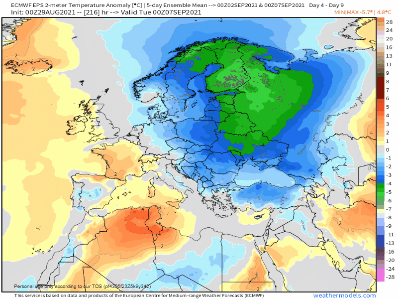
Remember those CFS snow maps I posted earlier out of Eurasia?? It is becoming clearer day by day that the pattern evolving across the "pond" over W Russia/Europe will support the onset of early snows. I think this is the harbinger of things to come as nature lays down the foundation...just like it will be doing on our side of the Northern Hemisphere over AK/Canada. Check out this temp anomaly off the 0z EPS as a very cold airmass will brew and spill over eastern Europe and W Russia in early Sept. I will confirm, based on conversations with my mother who has been in Poland this summer, it has become very cool of late. A vast difference from recent summers where its been anomalously hot. I wonder what the SAI index will start off like this year on Oct 1st??? Very interested to see what Dr. Judah Cohen will have to say about all of this in the weeks ahead. CFS still advertising widespread snow to overwhelm Russia throughout Sept.... Oct 1st...
 2 points
 -
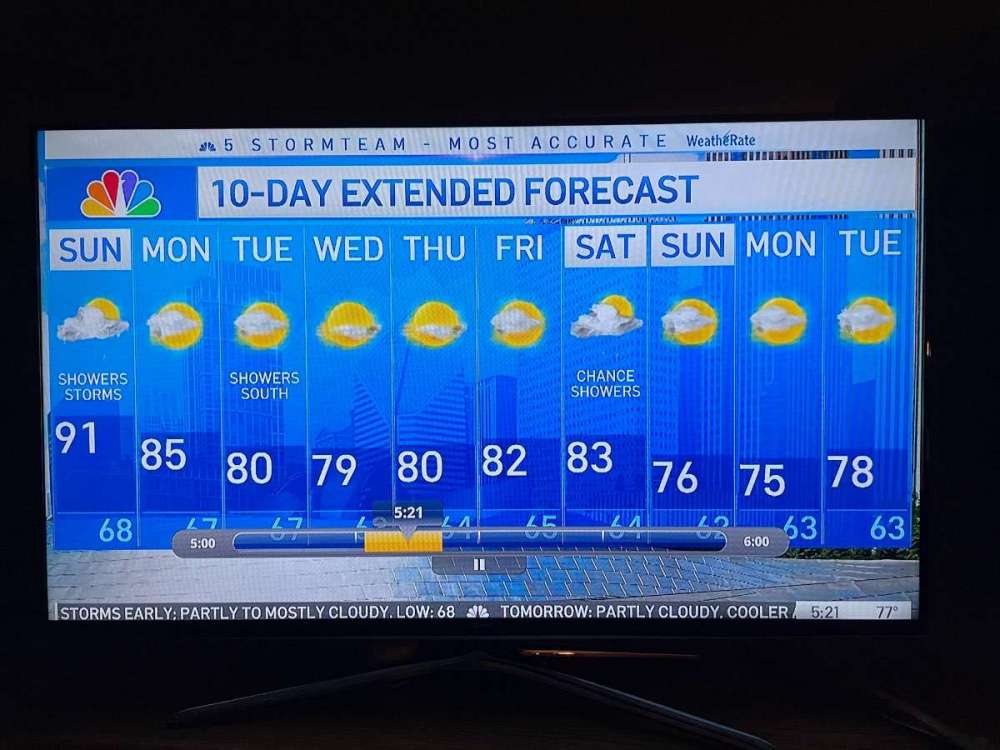
Rise n Shine! As daylight begins to emerge, I happened to catch this 10-day forecast and it shows nothing but sunshine after today’s possible storm action along a CF that is pressing through the region. Boy, these temps look amazing and Labor Day weekend is trending to be a great one.
 2 points
 -
It hit 92° here the last two days which are the hottest days for me so far this year. Dews in the low 80°s as well, but had decent winds2 points
-
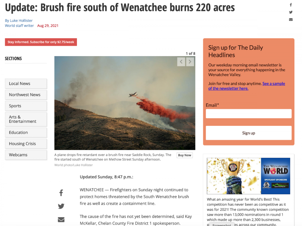
A new fire has sparked Sunday evening around 4:30pm in south Wenatchee. Roughly 300 homes have been order to evacuate. Luckily crews are hitting it right away with air support. I am heading to Wenatchee tomorrow... but maybe not now if it's just going to be a smokey mess. Wishing those firefighters the best. Contain and kill this fire before it keeps growing. Unfortunately there is no local news channel in Wenatchee (on the weekend) so there is no updates beyond what they post on line. (I'm glad they recently got a local tv news channel though within the past decade) [url=https://www.wenatcheeworld.com/news/local/level-3-evacuations-ordered-due-to-brush-fire-near-methow-street-south-of-wenatchee/article_75928aa4-092c-11ec-9e9f-67486a34e6f3.html]Wenatchee World Article[/url]
 1 point
 -
8/29/21 8:02 PM Oregon/Washington Large Fires Overview UPDATED Source: NWCC(Northwest Interagency Coordination Center), InciWeb) ____________________________________________________ * NEW FIRE ** UPDATED INFORMATION (Cause, Estimated Containment Date) ____________________________________________________ Oregon fires [6] (1) - BULL COMPLEX (Location: 12 miles NE of Detroit, OR) Acres: 9,398 (471) - Cause: Under Investigation - Percent Contained: 3% - Estimated Containment Date: 2021-10-30 - DEVIL'S KNOB COMPLEX (Location: 30 miles SE of Roseburg, OR) Acres: 32,391 (1,167) - Cause: Under Investigation - Percent Contained: 25% - Estimated Containment Date: 2021-10-15 - GREEN RIDGE (Location: 30 miles E of Walla Walla, WA) Acres: 39,633 (81) - Cause: Lightning - Percent Contained: 35% - Estimated Containment Date: 2021-10-15 - JACK (Location: 20 miles E of Glide, OR) Acres: 23,884 (18) - Cause: Human - Percent Contained: 53% - Estimated Containment Date: 2021-10-31 - MIDDLE FORK COMPLEX (Location: 9 miles N of Oakridge, OR) Acres: 18,506 (1,042) - Cause: Under Investigation - Percent Contained: 12% (2%) - Estimated Containment Date: 2021-10-15 - ROUGH PATCH COMPLEX (Location: 26 miles SE of Cottage Grove) Acres: 29,760 (15) - Cause: Under Investigation - Percent Contained: 11% - Estimated Containment Date: 2021-10-31 Washington fires [12] - BULLDOG MOUNTAIN (Location: 20 miles N of Kettle Falls, WA) Acres: 5,176 - Cause: **Under Investigation - Percent Contained: 47% (2%) - Estimated Containment Date: 2021-10-01 - CEDAR CREEK (Location: 4 miles WSW of Mazama, WA) Acres: 55,187 - Cause: Lightning - Percent Contained: 80% - Estimated Containment Date: 2021-10-31 - CHICKADEE CREEK (Location: 15 miles W of Tonasket, WA) Acres: 5,199 - Cause: Under Investigation - Percent Contained: 25% (10%) - Estimated Containment Date: 2021-10-15 - CUB CREEK 2 (Location: 5 miles N of Winthrop, WA) Acres: 70,186 - Cause: Under Investigation - Percent Contained: 70% - Estimated Containment Date: 2021-10-01 - DELANCY (Location: 4 miles W of Mazama, WA) Acres: 223 - Cause: **Under Investigation - Percent Contained: 95% - Estimated Containment Date: 2021-08-31 - FORD CORKSCREW (Location: 21 miles NW of Spokane, WA) Acres: 15,777 (9) - Cause: Under Investigation - Percent Contained: 92% (1%) - Estimated Containment Date: 2021-08-31 - MACK MOUNTAIN (Location: 15 miles N of Kettle Falls, WA) Acres: 1,233 - Cause: Under Investigation - Percent Contained: 25% (5%) - Estimated Containment Date: 2021-10-01 - MUCKAMUCK (Location: 3 miles NE of Conconully, WA) Acres: 13,119 - Cause: Lightning - Percent Contained: 60% (10%) - Estimated Containment Date: 2021-10-15 - SCHNEIDER SPRINGS (Location: 20 miles NW of Naches, WA) Acres: 78,937 (2,173) - Cause: Lightning - Percent Contained: 8% - Estimated Containment Date: 2021-10-01 - SUMMIT TRAIL (Location: 17 miles W of Inchelium, WA) Acres: 45,935 (189) - Cause: Lightning - Percent Contained: 52% (4%) - Estimated Containment Date: 2021-10-31 - TWENTYFIVE MILE (Location: 12 miles NW of Chelan, WA) Acres: 11,394 (137) - Cause: Under Investigation - Percent Contained: 32% (1%) - Estimated Containment Date: 2021-10-30 - WALKER CREEK (Location: 1.5 miles SE of Bonaparte Lake, WA) Acres: 23,412 - Cause: Under Investigation - Percent Contained: 30% (10%) - Estimated Containment Date: 2021-11-151 point
-
Looks like some nice stuff happening in San Diego County.1 point
-
Good news, temperature has only made it to 75 under cloudy skies. However, dews have stayed mid 60’s with no wind. Just too much moisture around, and not a strong enough cold front to scour out the humidity. Though it is about as green and lush as any late August I’ve ever seen.1 point
-
Thanks for the update Rob.1 point
-
59 (!!!) in Malibu right now! And this is supposed to be the hottest time of year at the coast?1 point
-
She’s a beast.1 point
-
Interesting forecast of Severe Thunderstorms and patchy fog in the same night.
 1 point
 -
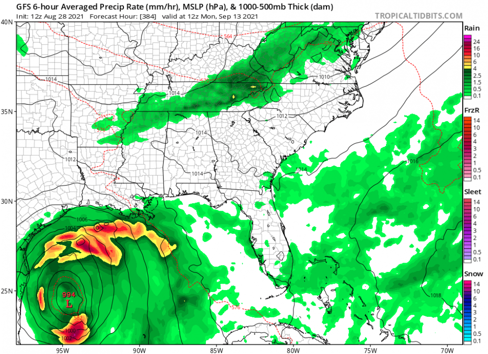
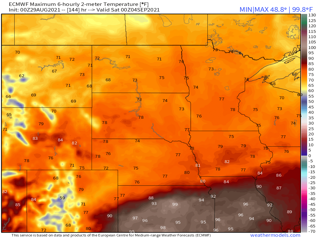
This is not what anybody in Louisiana wanted to see at the end of the 12z GFS but it is exactly what the pattern has in store. Louisiana is in for a rough road and will need a lot of help.
 1 point
 -
Bring on the 45 degree dew points! I have a landscaping business and it was a real struggle getting through this past week. Current heat (misery) index is 104 as I glance at my weather station. Dew point at 78!1 point
-
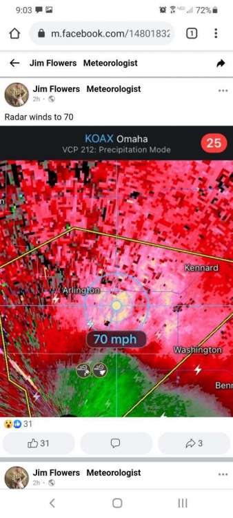
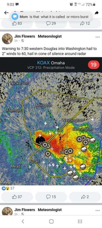
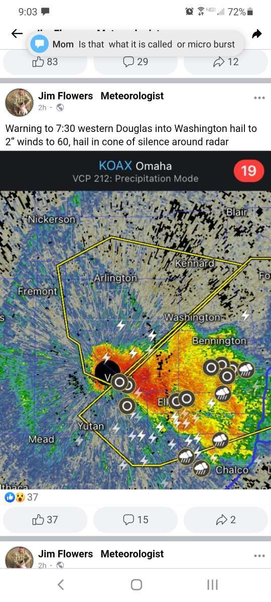
Went storm chasing this evening, was in valley, ne to just east of Arlington, ne
 1 point
 -
This humidity is why many move west.1 point
-
Looks like Arizona gets the remnants of Nora again while we miss out.0 points
-
81F dewpoint in Houma, LA.
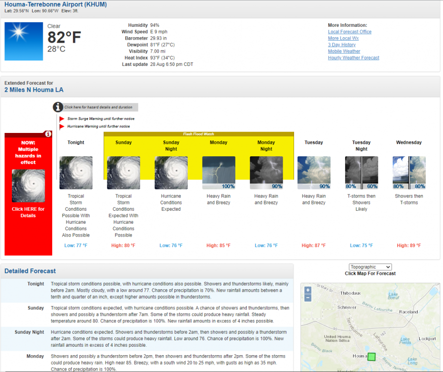 0 points


This leaderboard is set to Vancouver/GMT-07:00