
Leaderboard


Popular Content
Showing content with the highest reputation on 09/20/21 in all areas
-
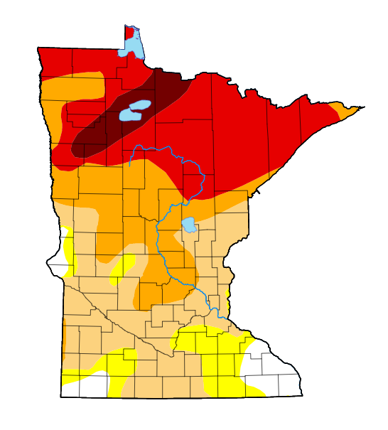
Last night was the rainiest night I can remember in forever it seems. 5-6 hours of constant rain shifting between steady, moderate, and heavy rain, nothing severe but decent amount of thunder. You really couldn't have drawn a better a better outcome for the D4 drought areas of northern Minnesota.

 6 points
 -
Persistent light rain for the past few hours here. 55°F.3 points
-
Severe Thunderstorm Watch til 10pm!3 points
-
67 degrees at 12:30 pm with a NW wind gusting to 25 MPH and a dew of 49. Low tonight of 48, high tomorrow of 68 and low tomorrow night of 41. Love this kind of weather.3 points
-
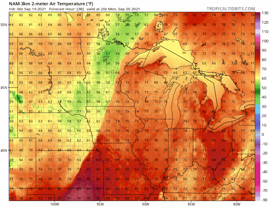
Love how those temps look behind that front!3 points
-
First fall like cold front is on it's way! Models showing .5-1 inch of rain possible for my area this evening but not much margin of error. If the storms fire further east I will be left high and dry.3 points
-
I'm hoping for a solid soaker this evening. Models have been consistently showing 0.50-1.00" across the area. Once again, it may be quite a while until the next rain. This summer sure has had a lot of long dry periods.3 points
-
Thankfully, the line filled in as it approached Cedar Rapids. I got a decent storm. It just didn't last long. My total is 0.51". Johnson county (Iowa City) ended up getting the weakest/thinnest part of the line.2 points
-
Severe Thunderstorm Watch about to be issued for KC area. High cape values 1500/2000 and dew points around 70 could make for some noisy storms2 points
-
Scattered thunderstorms happened this evening here. If you've ever been to the gulf coast and seen the radar on your average summer afternoon there, that's how the radar looks here. Really not helpful to the drought. Expecting a bit more with the fropa. 70°F.2 points
-
1.27" here for the evening1 point
-
The skies finally opened up here I received .60 inches. Another line is developing to my west so I may be able to add on some more. Temp is down to 73 and the wind is gusting to 35mph.1 point
-
Went to my son’s JV football game tonight. Sweatshirts on everyone. Temp was in the upper 50’s. It was chilly.1 point
-
Just looked at our weather almanac, I forgot that the autumnal equinox is Wednesday. Sunrise and sunset are both about 7:30. Average high temps are now low to mid 70's and lows are about mid 40's.1 point
-
80 here! Finally some real heat that reaches the coast again. Combined with the weak eddy, should be a boost for our iced over ocean waters.1 point
-
It's looking possible that there will be no measurable rain in Lincoln through the rest of Sept. (entire GFS run has nothing). If that's the case, KLNK will only have 0.31" for the month (7th driest on record). Though most of the rest of the town has more due to the storm at the beginning of the month.1 point
-
76 here! Was wondering if we’d ever hit that mark again this year without a Santa Ana event.1 point
-
It’s so nice finally have a full sunny morning for once. Its been over two months since that last occurred. Thats how bad the marine layer has been this year.1 point
-
Wind is weakly offshore here, allowing for a significantly warmer morning.1 point
-
Well defined “stratocane” near San Clemente Island this morning. And some of that haze looks like it could be smoke from the French Fire.1 point
-
Sun will be rising at the South Pole today, 2 days before the equinox.1 point
-
Despite an unseasonably chilly Pacific, there’s hardly any marine stratus in sight from Oregon to the Mexican border!
 1 point
 -
Nice to see cooler temperatures moving in. But more than 1.5 inches of rain in 50 days would be nice. Borderline absurd now. Despite decent rain at times its become way way to infrequent. Since July 31 barely a cloud. 3 light rains to settle dust.1 point
-
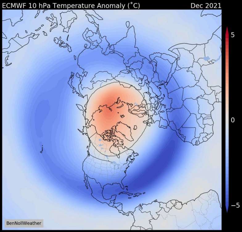
I've read several tweets from @BenNoll's comments regarding the potential for both a significant and early SSW event to occur over the N.H. This is interesting, for several reasons, but none moreso than the LR signal from an ensemble mean of climate models suggesting this could be the 2nd (if not earliest) SSW event in recorded history. Low Solar playing a role??? The high lat blocking which is to immerse the Arctic region later in early October is likely a very big clue. Not to mention, but look what is transpiring right now over the N Pole/Alaska as the 10mb/30mb upper atmospheric warming already brewing. Interesting commentary from him... How could you NOT be excited about this winter season??? The LR clues and signals are growing stronger as we get closer in time. Speaking of which, the CFSv2 continues to trend with abundant high lat blocking when just a few weeks ago the signal was very weak. I made a comment the other day where the model is playing catch up it seems as it is likely "seeing" the potentially historic SSW event. As I digest more data that continues to perk my interest for how this Autumn/Winter season ends up becoming, all you have to do is see what nature has already shown us. In my opinion, one aspect of what has transpired here in Arizona and the SW this Monsoon season is quite fascinating. We have seen an overwhelming amount of precip and I don't see this suddenly ending. In fact, I do strongly believe it will continue into October. Patterns like these don't just suddenly stop as I feel its more of a longer term trend. The fact that we are going to see such an enormous amount of blocking this coming cold season it is very conceivable that this will drive the jet stream farther south and become a factor in the SW U.S. Speaking of which, the CFSv2 is trending in a much wetter signal for the west coast and even down into So Cal! I love it... So, here we are in the middle of Sept with so much to look forward to as a winter wx enthusiast...are the models eye candy to look at? Yes...am I getting my hopes up to early??? Ehh, possibly....but when you see such a profound agreement in the modeling and not the conflicting signals you typically see at this range from the models you gotta get a bit excited, right?? Finally, I'll end this post with this comment that came from Dr. Cohen. If you recall, I've made several posts on the predicted pattern the CFS was indicating over near Siberia/Russia for this month into Oct. Well, it appears that both of us are on the same page...
 1 point
 -
We'll be tracking our seasons strongest Autumnal CF right on que....it's like a wall of cool air will spill into the region. Imagine tracking something with this type of vigor in the Winter...boy, I'd like to see these fronts as we roll into the early part of Winter around the holidays. How about you?
 1 point
 -
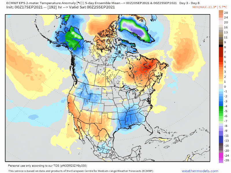
Happy Friday! The countdown to astronomical Autumn continues as we only have a few more days of Summer left and it will feel like it back home today. Upper 80's are in the forecast for ORD as late season warmth pokes out ahead of a CF straddling the northern Sub. There may be one more day of late season warmth early next week before the pattern really takes a turn and will feel like Autumn. Low and Behold, mother nature is going to welcome Autumn right on cue with a strong CF sweeping through the center of the nation. 0z Euro morning lows on 9/22... As the sun sets way up north, I'm inclined to believe the first bits of info on the developing cyclical pattern is evolving. I can't help but notice the strategic blocking patterns that suddenly blossom on 9/22 and the days ahead to close out the month. I've been studying the data coming in from the various models to get some insight on what we may be seeing in the weeks and months ahead. This morning, I "saw" something in the 500mb pattern that I've seen numerous times while combing through data. Ironically, it matches what the CFSv2 and other climate models are suggesting for this Autumn/Winter. By late month, notice the corridor that develops from AK and through W Canada into the our Sub...a massive West-Based Greenland Block/SW Ridge will ultimately set up an expansive trough into our Sub. For the record, as we get closer in time, the CFSv2 is seeing the Greenland block develop more epansively in the data. If you look out ahead into mid/late winter it looses it. This was a problem last year I recall vividly when not only this model, but you can also say that all of the others missed on the blocking. Can you see what I see? It's strikingly similar....nature provides clues and this is one of them IMO... With that being said, it is looking quite cool for the eastern Sub to close out the month...Who's ready for fall-like weather??? Full disclosure, I'm ready for those cool and crisp mornings while sipping on my morning coffee...

 1 point
 -
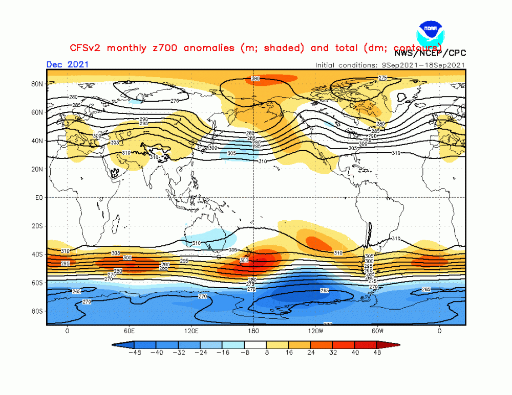
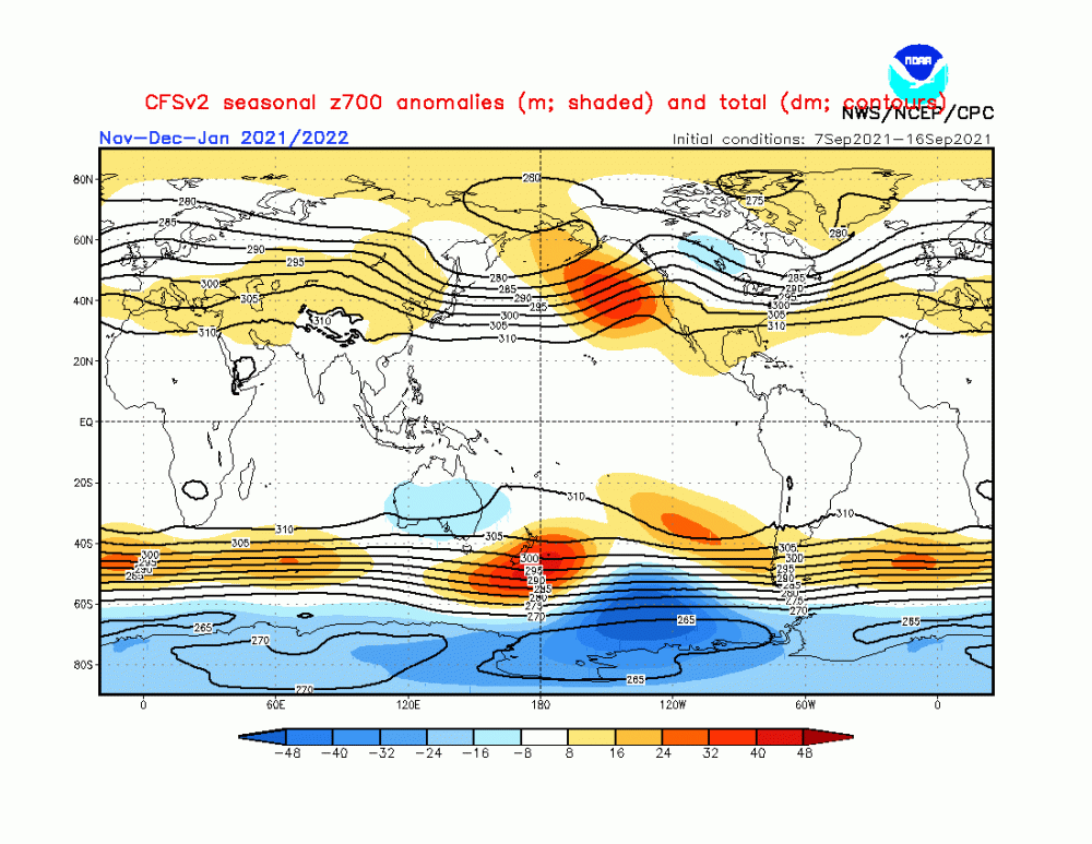
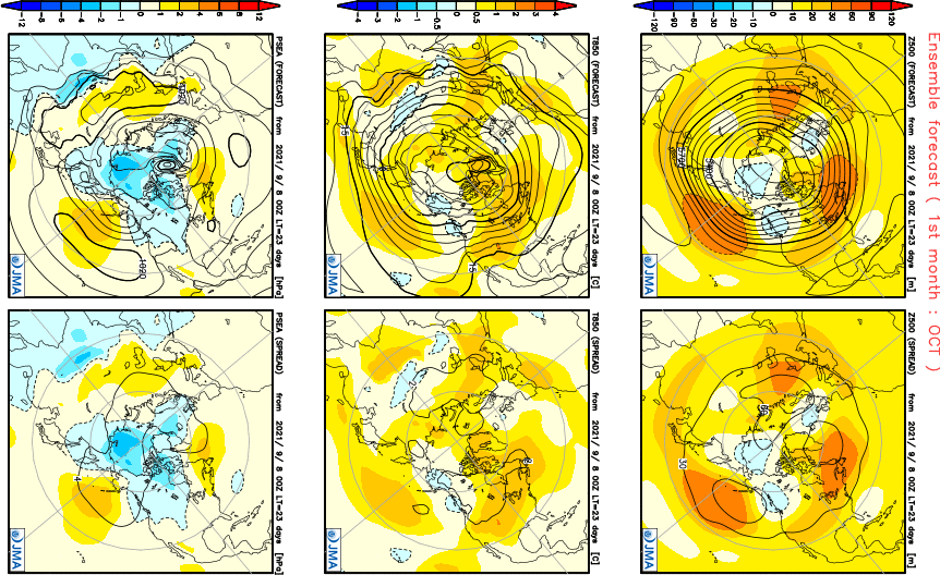
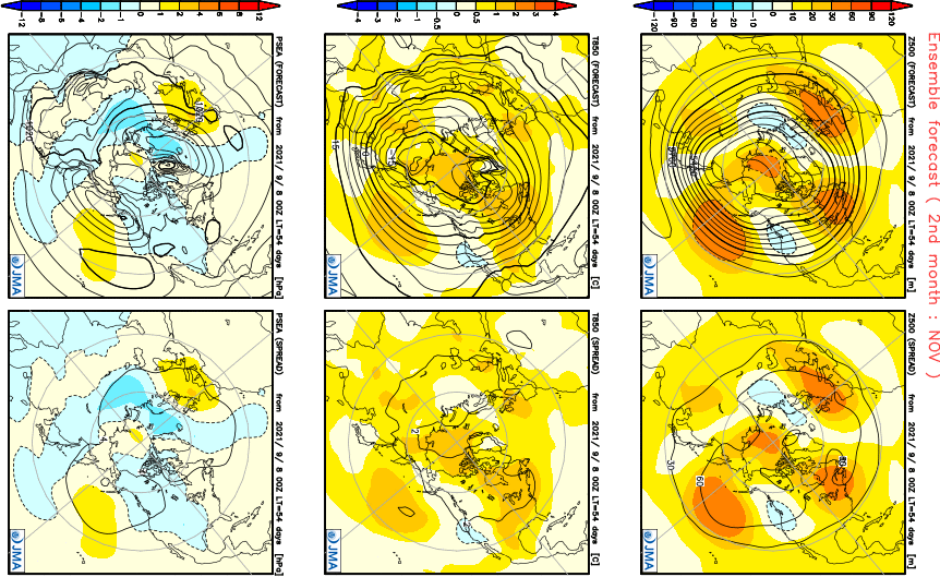
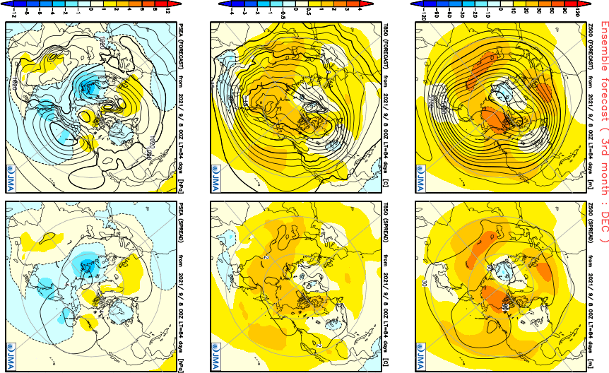
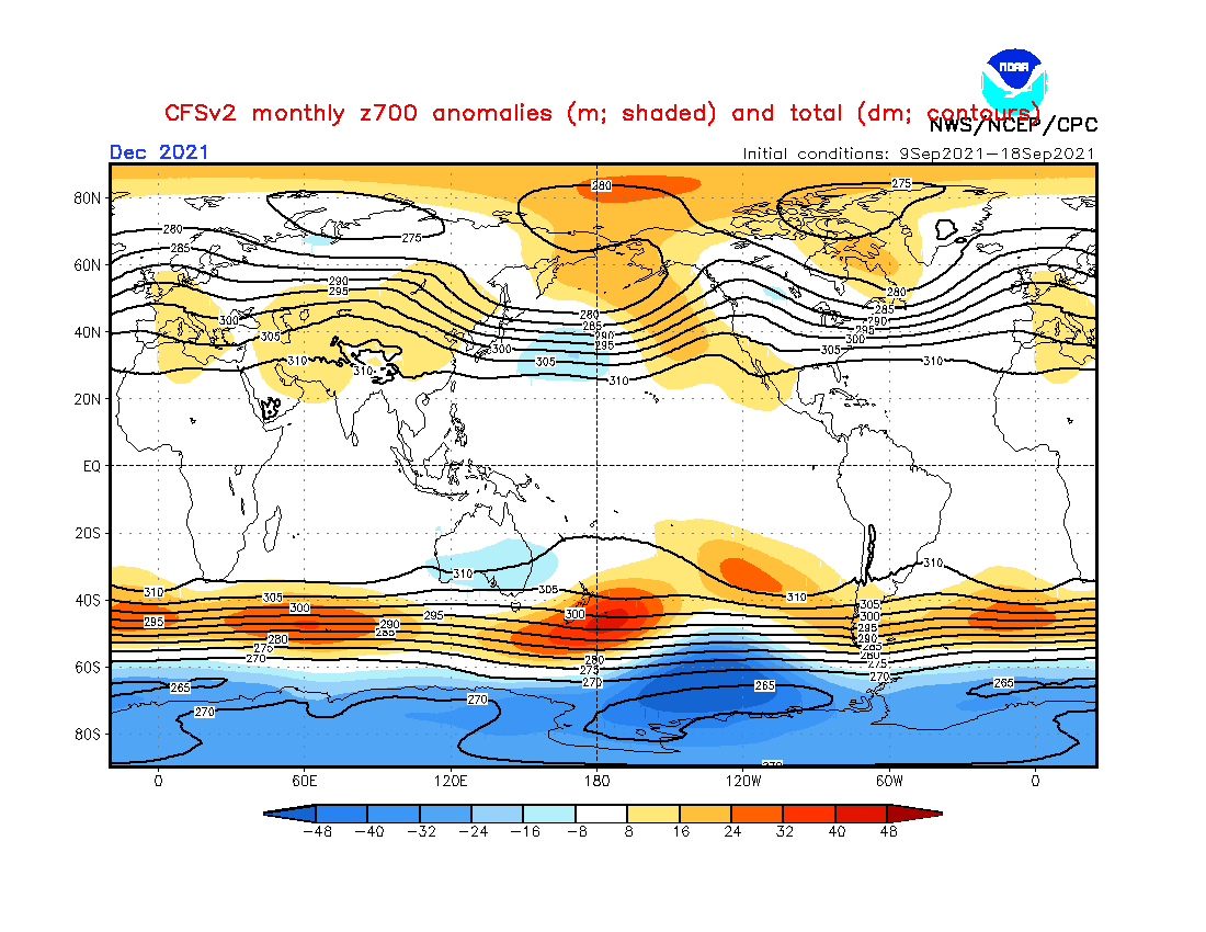
As promised, I'll post the latest maps off the JMA seasonal that came in the other day. What I find interesting, is the model agreement between the CFSv2 and JMA for the month of October. The trough near AK/NW C.A. signalling winter will hit it off quickly up that way while farther south down into the U.S. a warmer pattern may be in the cards next month. Temp...overall a slightly AN temp pattern from the SW into the W GL's region while a hint of normal temps near the PAC NW and SE CONUS. Precip...it appears like a normal precip pattern across the eastern 2/3rd's of the nation but a wetter potential pattern across the west coast and So Cal?? That would be very interesting if this ends up being right and nature delivering moisture into So Cal. As we approach November, I think the model is signalling major blocking patterns in and around North America. This, IMO, is a huge factor going forward for many reasons as it will solidify the LRC pattern that will undoubtedly favor a Greenland Block and -AO. Notice the trough that is targeting the PAC NW/W Coast and the big block in eastern Canada. This is fantastic signal for a significant storm train to inundate the west/SW which eventually make it into our Sub Forum. It's no surprise that the precip pattern is showing a very large area of AN precip from the west into the eastern CONUS. Temp/Precip... Precip....the W PAC signal is one to watch in the month of November as it could deliver some powerful late season Typhoons. I remember one year when Typhoon Nuri tracked up near East Asia into the Aleutian Islands that was a big part to the pattern in mid November back in 2014. We could very well see something similar. Notice the trough near Japan and using the East Asian rule, this is indicative of stormier pattern for the eastern CONUS. Typhoon Nuri's track... Finally, the time of year when we all want to see cold air and snow falling during the holiday season that has been lacking in recent years. Well, if the JMA is right, I think there will be smiles on peoples faces. I mean, you can't script this any better after looking at the 500mb pattern. #eyecandy Temp/Precip...let's hope this holds....no warmth whatsoever across the CONUS (the model does not really "see" cold at this distance). Precip...nearly the entire Sub Forum has AN precip. Like I've said before, I got a great feeling that due to what has transpired here in the SW during this years Monsoon season, I strongly believe Nature will be delivering many storms out this way in the Fall/Winter. These maps are mirroring what I think will transpire. Overall, there will be some warmer periods in Oct/Nov but the general them is for a very active storm track and then possibly a big flip into Winter sometime in Nov or early Dec. I'm really getting excited and antsy to start seeing storms track into the west, esp if the high lat blocking takes over and also the big ticket item...what happens in the Strat? Early disruption like the models have been suggesting over the past couple months? Lot's to decipher over the coming weeks.
 1 point
 -
.13” here. Rained for 5-10 minutes.0 points
-
It's looking like the best rain wants to track north and south of Cedar Rapids.0 points
-
Hazy here this morning.0 points


This leaderboard is set to Vancouver/GMT-07:00