
Leaderboard


Popular Content
Showing content with the highest reputation on 09/24/21 in all areas
-
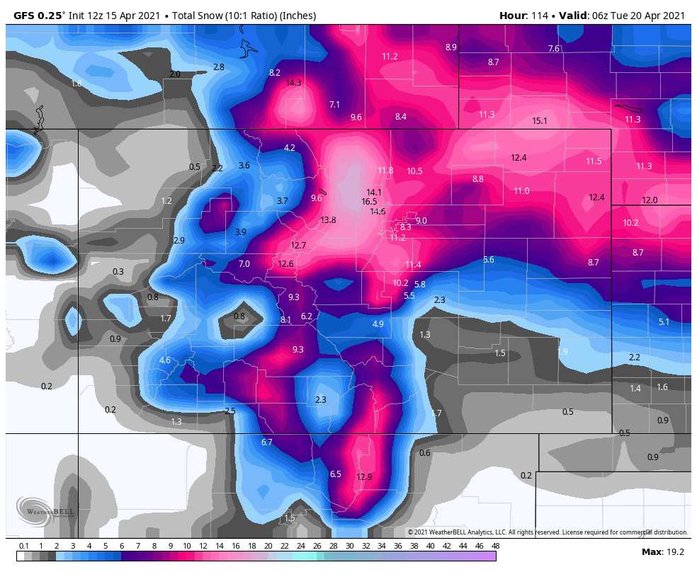
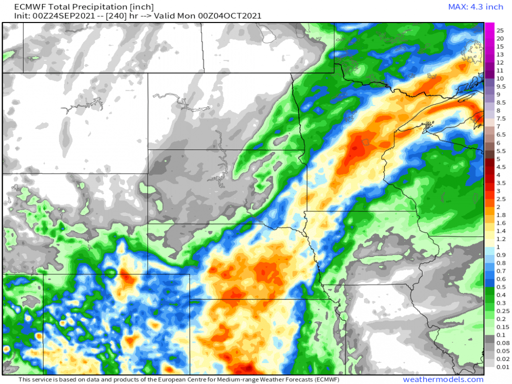
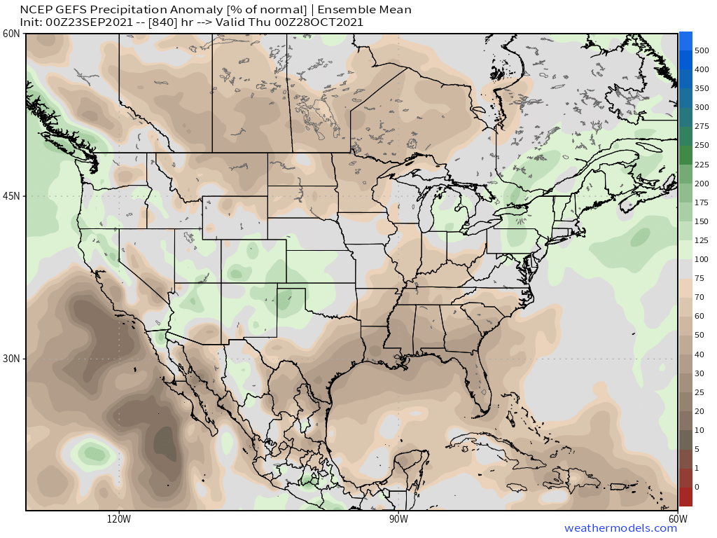
The wx pattern over the next 7-10 days looks phenomenal around these parts. Not to hot, not to cool...plenty of sunshine and comfortable DP's...nothing but 70's and some warmer low/mid 80's for a few days later next week. The only "issue" I see is the drier pattern over N IL/S WI were the drought has intensified once again since it's been so dry this past month. If we'd have our first frosts, this wx pattern would constitute as prime time Indian Summer wx. In other news, it has been very dry in the SW/TX Pan Handle region but nature is going to flip that script and provide abundant moisture. The models are locking in on a ribbon of heavy precip up through the C Plains and SW... As we get closer to the period when the new LRC begins, I'm beginning to see a new pattern mixing in as we close out this month and enter the first days of Oct. Needless to say, I'm enthusiastic to see the wetter pattern setting up in the SW/S Plains. Nature providing some initial clues as I foresee this will be an exhibit to the new LRC pattern..."Southern Stream Storm Track"...there is just an overwhelming signal for blocking to be present across the north next month. Let's see how this all shapes up. LR GEFS....notice the ribbon of AN precip from Cali/SW/Plains into the GL's...hmmmm
 4 points
 -
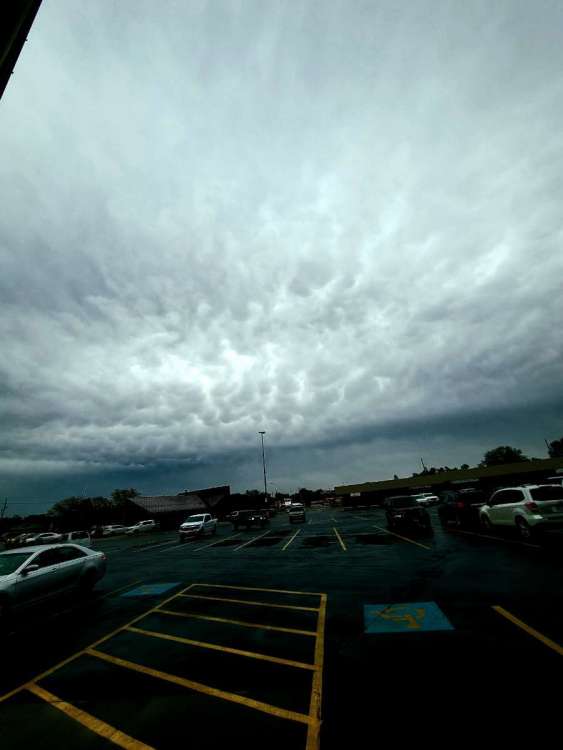
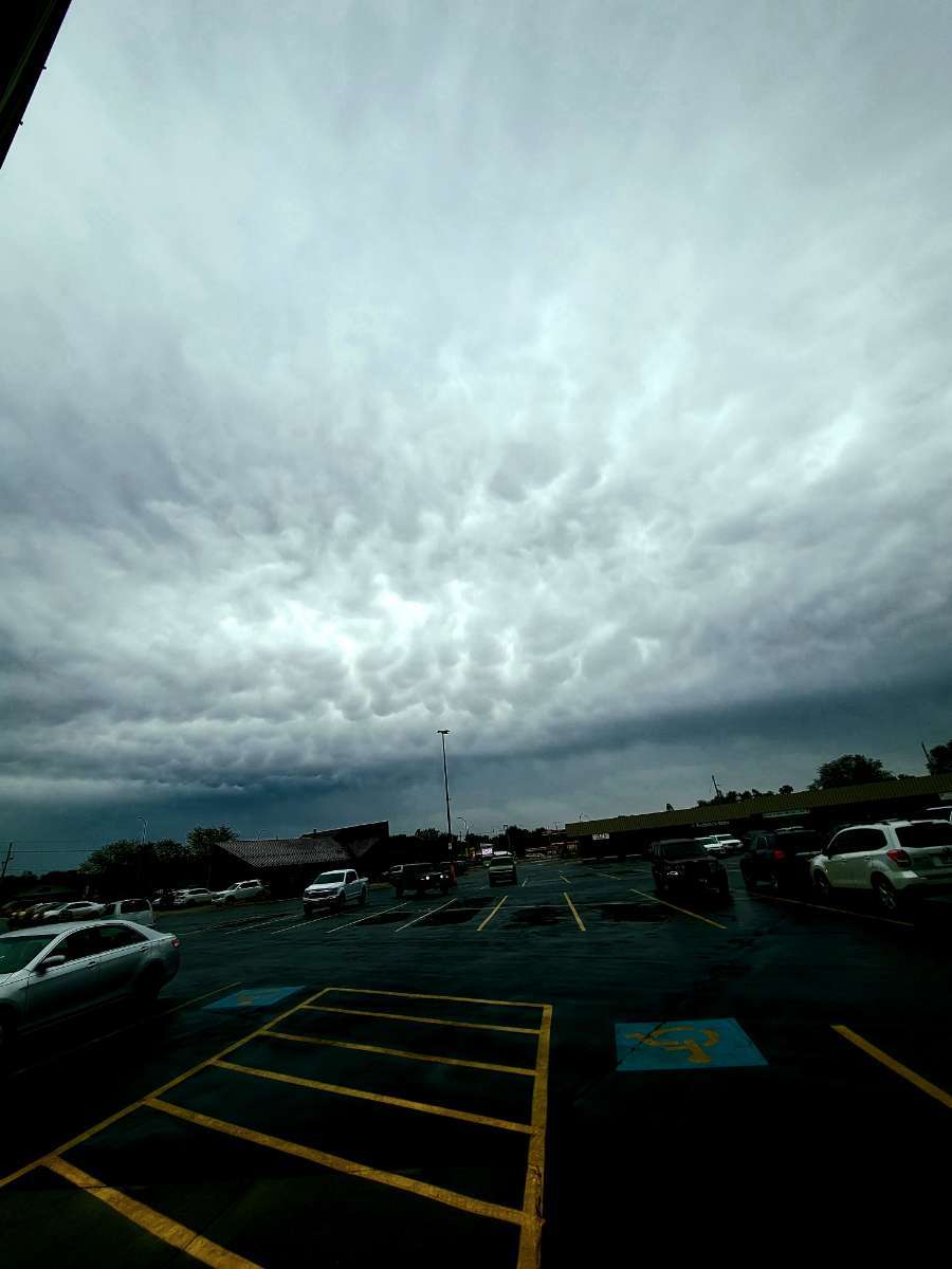
We have a thunderstorm3 points
-
Hello Tom Greetings from Los Angeles, Ca. I am currently in Santa Barbara and I gotta tell ya, its pretty nippy here. Low clouds currently w temps holding in the upper 50s. Highs here not getting outta the 60s. (Goleta is the place to be exact where I am currently at). Came for a wedding. Flew to Lax 2 days ago and drove north to Santa Barbara (took route 101). Gotta tell ya, luv all of these "Palm Trees" around. Very nice area here. Btw: I flew over your area (Arizona, near Flagstaff). Anyways, hope everyone had a great Summer and a safe one for that matter. Been traveling quite a bit these past few months, so lots of catching up to do once I finally get back to Detroit. Btw: I heard about that wicked storm Detroit had couple of days ago. Holy smokes! Excellent track for an epic winterstorm. Had it been Winter, over 4ft would had fallin in the Detroit Metro area. Hopefully a sign of great snowstorms ahead for this upcoming Winter.3 points
-
I was in Kzoo on business today. Pretty amazing that Marshall was 49F at 1:30 pm. Has to be some of the colder temps in Sept 23 history. Kinda reminded me of some of the cold of '81 and especially '89. The first flipped at Christmas with the mega-Nino, while '89 was very cold and remained at least somewhat cold and snowy into the new year. It was decent. My last winter in SEMI before moving north.2 points
-
Brief shower earlier
 1 point
 -
Temp dropped from 72 to 55 after the front passed. Wow! Had a quick shower too but just 0.08"1 point
-
Nice showers for Reg and south of Salton Sea. A nice flow of Pacific moisture helping a small popup cyclone just south of Yuma. It is interesting that the very driest part of the blocking high (as viewed with the upper water vapor image) has moved rather quickly- over the last 48 hours -to a position SE of the Hawaiian Islands.1 point
-
Good to hear from ya and enjoy the west coast trip. I love heading out to the west coast and seeing the ocean along with enjoying the beautiful wx (except for today). It’s rare to get that chilly out that way during the summer. That cut off low is ill-timed!1 point
-
Going to be a beautiful night for HS football. Temps dropping through the 50's this evening and bottoming out at 45. Heat comes back Sunday-Tuesday. However, NWS Hastings is starting to ramp up precipitation for Wednesday and beyond as this system comes out of the Southwest.1 point
-
@jaster220 @Tom I don't know how that afternoon reading of 49 stands up for during the day time but at Kalamazoo the highs on the 22nd and 23rd of 58 and 59 were the 5th and 8th coldest for the dates at Kazo and the official rain fall of 1.40" was the 3rd most for September 23 at Kazo.1 point
-
KYIP finished at 3.84" mostly from first round, while KRMY rallied with the ULL last night to score above forecast at 3.25"1 point
-
I was sick of it before I got here lol I'm trying to get out.1 point
-
Jim Flowers posted this video yesterday. He is showing a pattern change by mid October with much cooler air, although he thinks the model is seeing it as "too quick". He also mentions '08-09' as his preferred analog year for this upcoming Winter. https://www.facebook.com/148018328718825/posts/1821440708043237/1 point
-
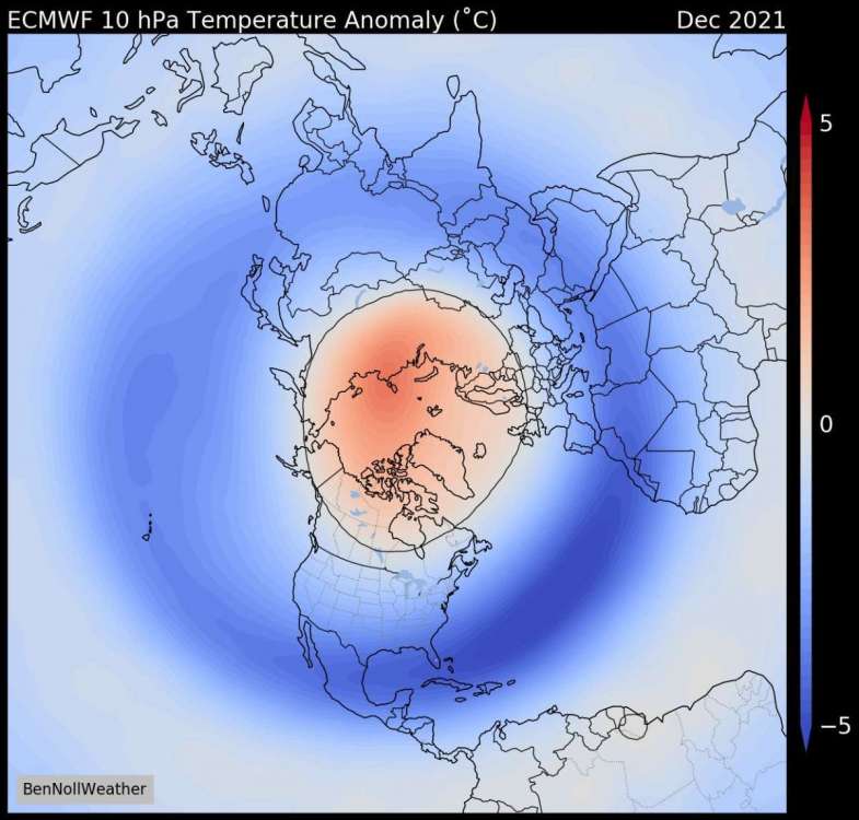
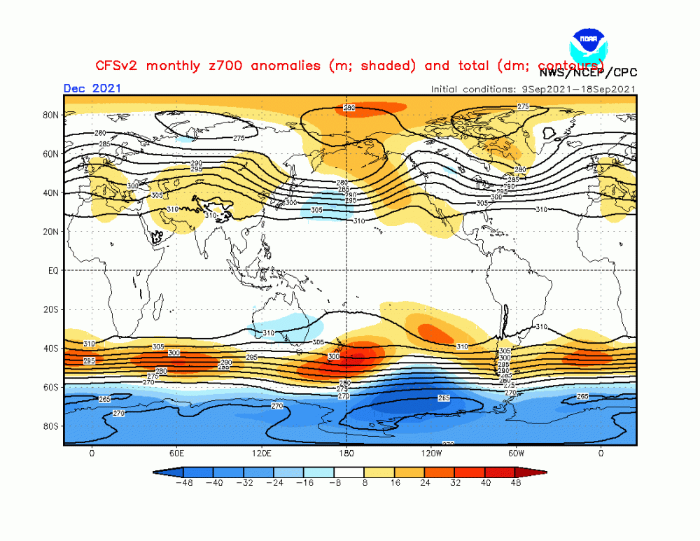
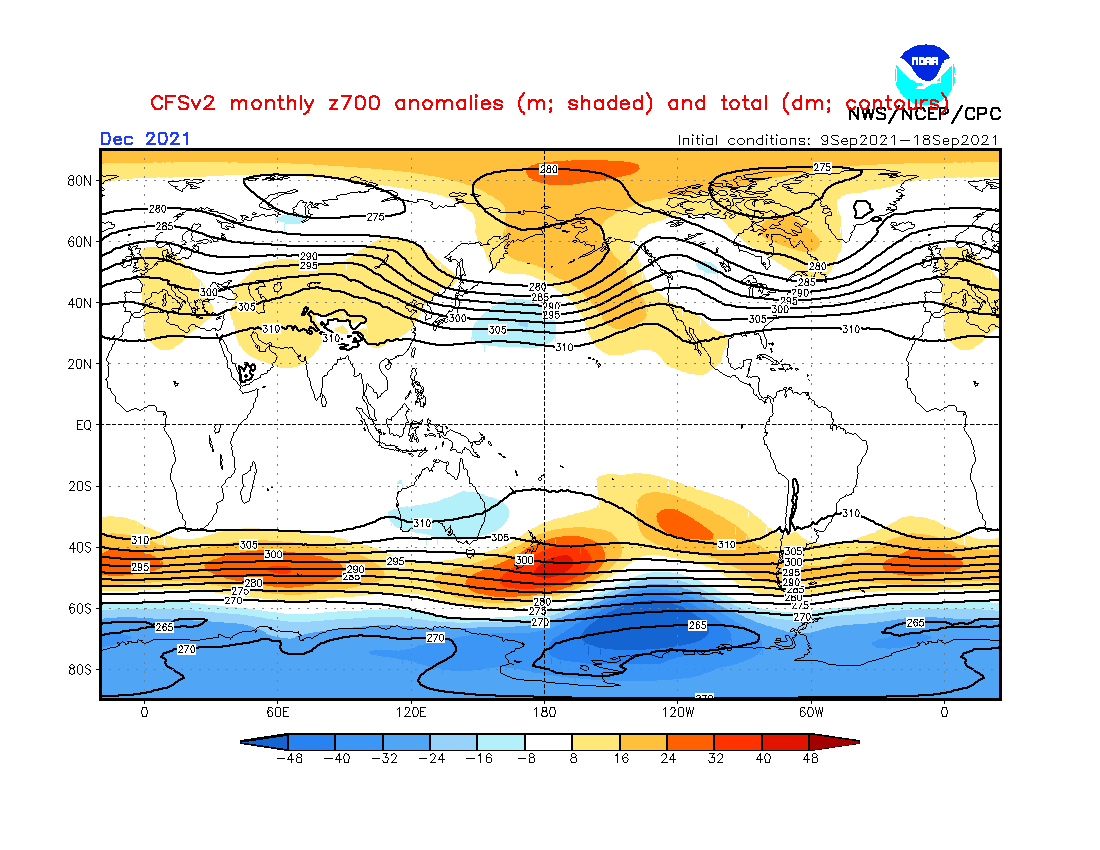
I've read several tweets from @BenNoll's comments regarding the potential for both a significant and early SSW event to occur over the N.H. This is interesting, for several reasons, but none moreso than the LR signal from an ensemble mean of climate models suggesting this could be the 2nd (if not earliest) SSW event in recorded history. Low Solar playing a role??? The high lat blocking which is to immerse the Arctic region later in early October is likely a very big clue. Not to mention, but look what is transpiring right now over the N Pole/Alaska as the 10mb/30mb upper atmospheric warming already brewing. Interesting commentary from him... How could you NOT be excited about this winter season??? The LR clues and signals are growing stronger as we get closer in time. Speaking of which, the CFSv2 continues to trend with abundant high lat blocking when just a few weeks ago the signal was very weak. I made a comment the other day where the model is playing catch up it seems as it is likely "seeing" the potentially historic SSW event. As I digest more data that continues to perk my interest for how this Autumn/Winter season ends up becoming, all you have to do is see what nature has already shown us. In my opinion, one aspect of what has transpired here in Arizona and the SW this Monsoon season is quite fascinating. We have seen an overwhelming amount of precip and I don't see this suddenly ending. In fact, I do strongly believe it will continue into October. Patterns like these don't just suddenly stop as I feel its more of a longer term trend. The fact that we are going to see such an enormous amount of blocking this coming cold season it is very conceivable that this will drive the jet stream farther south and become a factor in the SW U.S. Speaking of which, the CFSv2 is trending in a much wetter signal for the west coast and even down into So Cal! I love it... So, here we are in the middle of Sept with so much to look forward to as a winter wx enthusiast...are the models eye candy to look at? Yes...am I getting my hopes up to early??? Ehh, possibly....but when you see such a profound agreement in the modeling and not the conflicting signals you typically see at this range from the models you gotta get a bit excited, right?? Finally, I'll end this post with this comment that came from Dr. Cohen. If you recall, I've made several posts on the predicted pattern the CFS was indicating over near Siberia/Russia for this month into Oct. Well, it appears that both of us are on the same page...
 1 point


This leaderboard is set to Vancouver/GMT-07:00