
Leaderboard


Popular Content
Showing content with the highest reputation on 10/23/21 in all areas
-
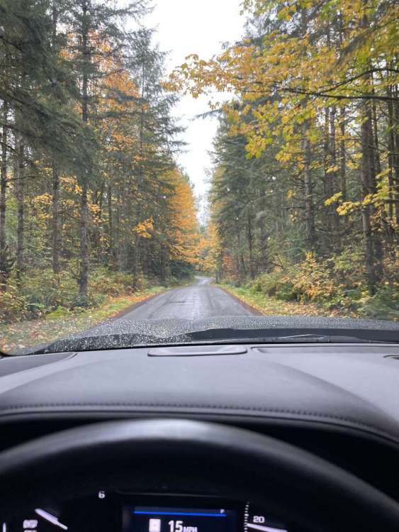
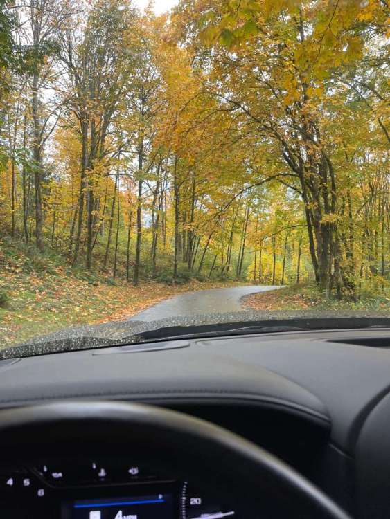
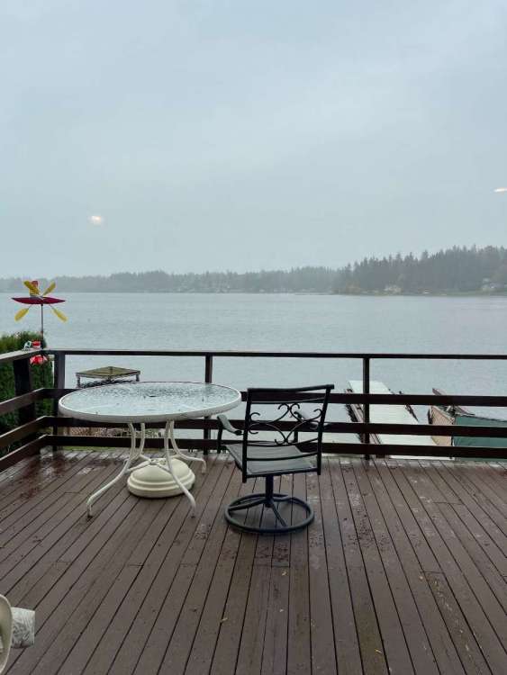
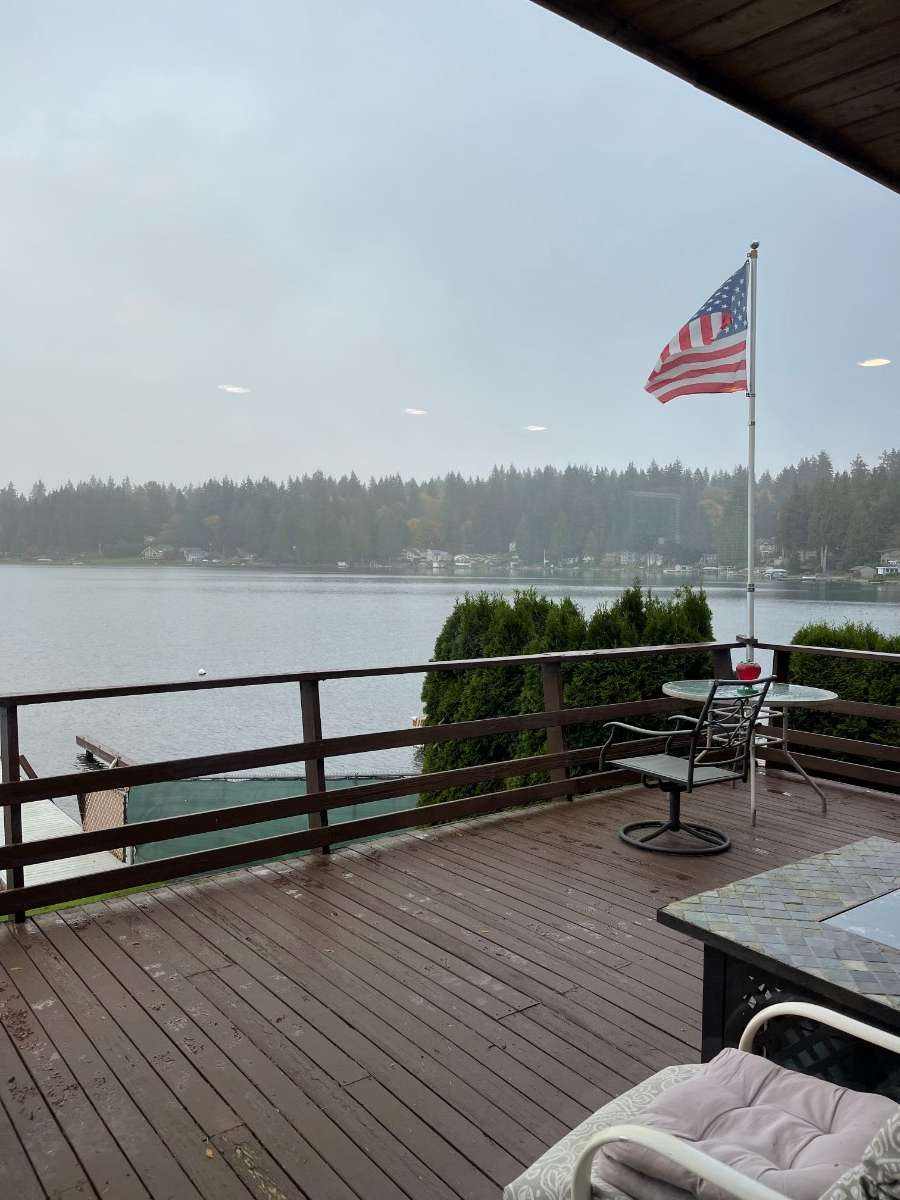
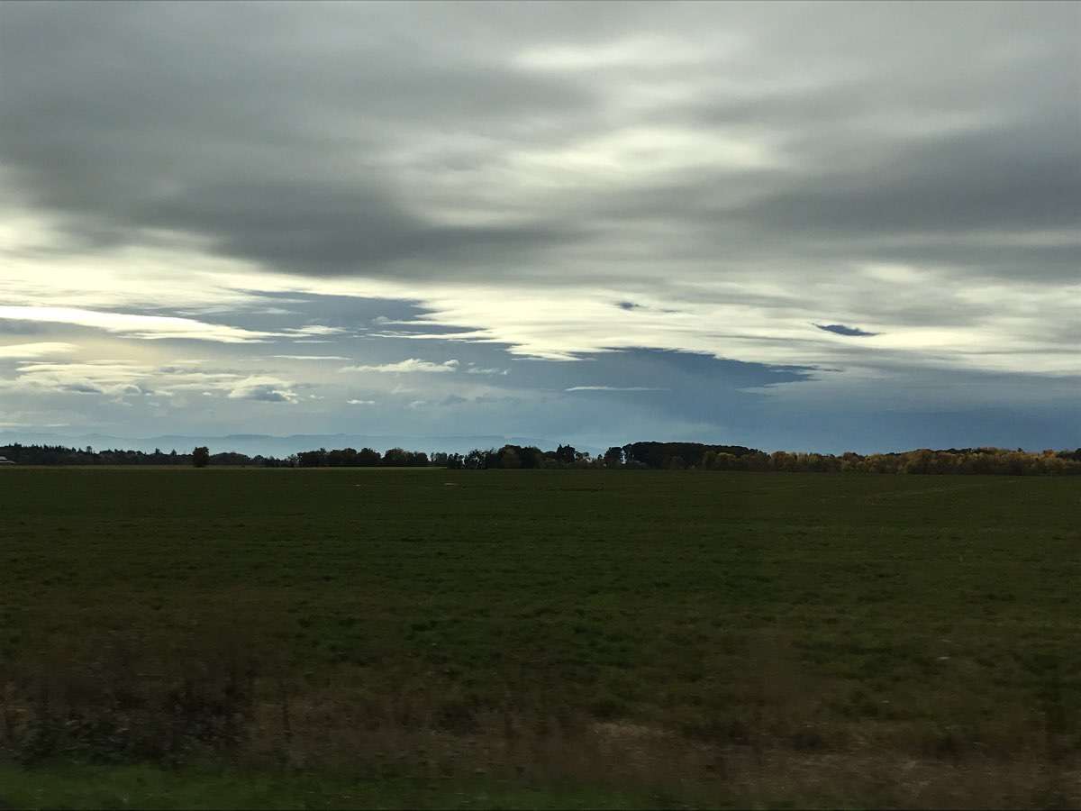
Absolutely gorgeous drive to and from my friends place in Carnation this morning, the color was amazing! There where not many places to easily pull off of SR-203 but I did take a few pics up off of the side road by their property. Then stopped at the Lake Goodwin lake house on the way back. Was a drizzle fest! .16” so far on the day at home.
 10 points
 -
Salmon fishing off the Klickitat R the other day. The sunrise was so spectacular the salmon were even jumping out of the water to take a look.
 10 points
 -
Beautiful fall weather and fall colors on display today. I’m really lucking out on the weather with this trip!
 9 points
 -
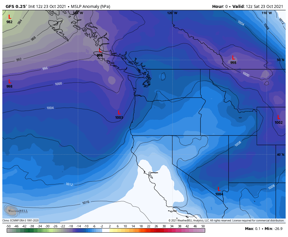
For those whom put stock in CPC 6-10 day and 8-14 temp forecasts ( I never have as the bias is obvious) where was this cool shot 1-2 weeks ago??? Not even close to what has happened. DSM is going to be -6F ( or so) for a 5 day period starting on the 21st - through the 25th. And that is "above normal" according to previous outlooks??? CPC is blinded by political issues. No accountability either. Sorry for the rant and truth. And yet their winter forecasts are what get blasted on main stream media. Even Jim Flowers called them out on that. Sorry for the rant, but Truth will set you free!!8 points
-
Today I got some new tulips planted, got some plants cut down, got the lawn mowed, and got the patio cleaned up. I'm ready for a nice soaker.7 points
-
Looking ahead... the GFS shows a little bit of rain for the Seattle area on Thursday and Friday.6 points
-
Looks like an ultrasound. Congrats! It’s a bomb cyclone!6 points
-
Pic from this morning. Got down to 36 and we even had 0.65 of rain yesterday, which was awesome.
 6 points
 -
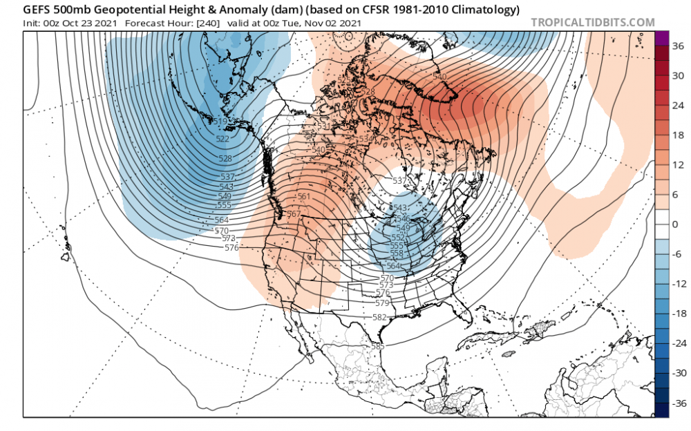
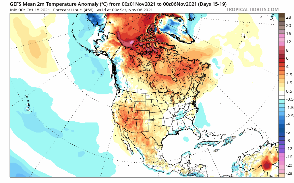
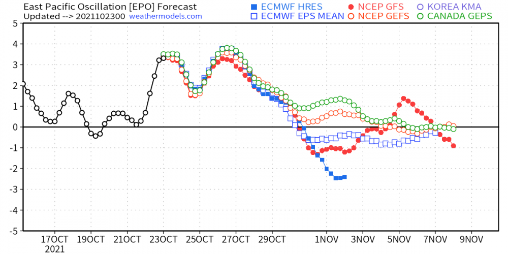
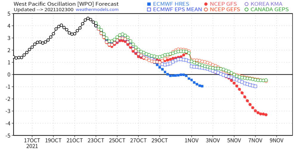
I usually don't start a thread this early but this year will be different. In many ways, this month is going to be an impactful one for much of our Nation. I'm inclined to believe there will be several bouts of Severe Wx accompanied by the battle with Ol' Man Winter. What is Nov '21 going to be remembered for? Is Winter coming out of the gates early?? What will the holiday season look like? This is the time of year when I personally start to enjoy tracking autumn/winter storms as our Sub comes together and members become more active. I'm excited about what I see coming down the road for this month. Alright, alright, alright...I've done enough digging/studying and deeply focusing on some intriguing data that continues to support the long standing idea for a big reversal heading into November. All systems are ready to "GO" as we open up the door to Novembrrrrr....that's right, it's looking very likely that just as we open up the month, in a timely fashion, our seasons first big shot of early season cold is on the way. Ya'll know how I enjoy seeing the wx line up to specific calendar dates. Right on Cue, the entire North American 500mb flips a switch from Ridging across central/eastern Canada to what I foresee will be the next Long Term Long Wave trough of the developing LRC....Hudson Bay Vortex.... 7 Well, this certainly flipped pretty quick...last 6 runs off the GEFS...opening week of November is going to FEEL cold after such a warm Oct. As the fastest cooling month of the year opens up, temps also appear to follow suit and take a dive... 0z EPS... What about storms??? Oh boy, there are plenty on my calendar in what will be a series of systems coming out of the SW...aka "SW FLOW" where this years LRC's golden hot spot has set up. Using the BSR as guidance, there is data to support the idea that during the week of the 7th, I'm seeing back-to-back southern stream systems coming out of the SW/TX PanHandle region. "Cutter Week Special" Round #2??? Just like in early Oct, in similar fashion, either this is another harmonic beat of the LRC or maybe a secondary active part of the entire cycle. Nevertheless, the pattern setting up is eye candy and one that will keep us ALL busy tracking storm systems. Storm Target Dates during Week 2 of Nov: 11/7-11/9, 11/11-11/13 (Veteran's Day Winter Storm?). Doesn't it always seem like we are tracking some sort of system around Veteran's Day...iirc, someone's B Day is around that day also @james1976??? Anyway, we will prob seeing a winter component during this period. Winter is likely to show itself in an abrupt fashion Week 2 of November. No joke, but it's like everything is lining up right as we enter November...I mean, you couldn't script this any other way....look at ALL the teleconnections from a variety of models...that is quite rare to see practically all of them flip in sync. I'm amazed at what I see happening. Lastly, #ThinkSnow...I'm predicting that a number of places across the central CONUS have a good shot at breaking records. It ain't just a mere fantasy, but a legit prediction that the overall pattern for this month will deliver bountiful chances of Snow. No doubt about it. The Euro Weeklies from Thursday illustrate a solid idea of whats coming down the road. This is just before the beginning of the holiday season...once we get towards the middle/end of Nov, I think we'll see the cold press farther south and east. I know this has been a long post but I had a lot on my mind....who's ready for tracking????

 5 points
 -
Mesoscales definitely speeding up the system in addition to shifting it eastward-- hmmm.....5 points
-
Picked up .75 in the gauge this morning. The weekend is off to a wet start.5 points
-
It's 7-10 day snowstorm teaser season.5 points
-
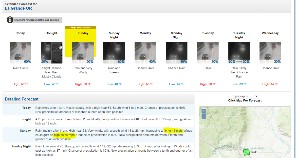
La Grande, OR is looking very windy tomorrow! Could see strong tropical storm like gusts!
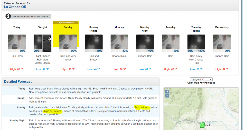 5 points
 -
We definitely got our first freeze this morning, along with heavy frost. The CR airport hit 29º and the station down the road from me hit 30.8º. Waterloo and Marshalltown hit 26º and Mason City hit 23º!5 points
-
Waking up to a little rain this morning as I'm on the northern edge of a shield of rain being caused by a developing warm front. A chance for some good rumbles tonight. The SPC has me in a slight risk.5 points
-
I’m in the Ozarks this weekend in far NW Arkansas near a small town called Garfield. Gorgeous weather here. Highs were well into the 70s today maybe even hit 80. Very little wind as well. Can’t say I’m looking forward to the 40s I’ll be coming back home to tomorrow.4 points
-
A little info about the 1934 event... The gale of '34 appears to have been the biggest, most destructive storm to strike the Pacific Northwest in the time period delineated by the January 29, 1921 and Columbus Day 1962 windstorms. For some Puget Sound locations, such as Seattle, this was possibly the strongest storm on record. The extratropical cyclone brought high winds and widespread damage to all three of the major population centers: Portland, Seattle and Vancouver, British Columbia. Numerous buildings were damaged or destroyed. Unreinforced masonry walls and chimneys collapsed, roofs took to the air, boats sunk, countless trees toppled sometimes crushing cars and structures, fences fell, powerlines were downed and telephone service rendered inoperative (Vancouver Sun 1934a). In a manner similar to a hurricane, the combination of low pressure, strong winds and high tide produced a storm surge on the Pacific Coast that flooded many neighborhoods and towns. In some cases people were trapped by the rising water and had to be rescued during the storm. The gale was also deadly, taking a human toll that is second only to the Columbus Day Storm of 1962. At least 18 people were killed in this event, many from collapsing structures and sunken vessels.4 points
-
I think the only winners in a windstorm are the ones who get the least wind4 points
-
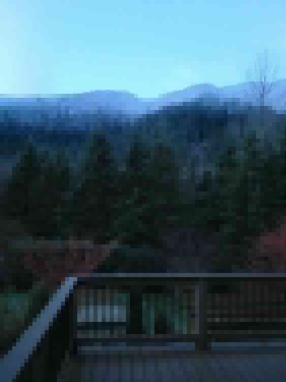
Heading to the upper McKenzie River with the adventure club at OSU. Here’s a nice little south valley scene.
 4 points
 -
Good idea. My wife wants to get a larger propane heater for the tent. It has a carbon monoxide sensor but it still makes me nervous to sleep in the tent with it. In Wyoming I kept opening the tent a little once she fell asleep which is probably part of why she thinks we need a bigger one. Lol4 points
-
Agree x100...I personally think they are not preparing the public for a robust Winter ahead for the eastern 2/3rd's of the nation. I dunno, but sometimes I feel they hold way to much bias as you've stated. Meantime, a wild week of wx heading for us to close out the month. Fun times ahead Grizz! Fired up a new thread for November... https://theweatherforums.com/index.php?/topic/9236-november-2021-observations-and-discussion/4 points
-
Waiting for skies to clear up so temps can drop. First Frost advisory of the season...check that off the Autumn list...prob going to do some final garden/yard work, cover the A/C and put my patio furniture away later today before the soaking rains. Leaves continue to fall at a slow pace so no raking just yet. I gotta feeling they will come down quickly once we turn the calendar into November.4 points
-
00z GFS, ECMWF 2 Day Rainfall totals3 points
-
I like the new “the swamp” name much better than the dots!3 points
-
Definitely an eastward trend with the short range models. Could end up being advisory levels most places.3 points
-
...Oregon Coast... Scattered low-topped convection will develop within an environment characterized by very strong shear and weak instability but steep lapse rates. These storms may become capable of producing a few damaging gusts and possibly a couple of tornadoes later Sunday afternoon and evening.3 points
-
heard about a bombing cyclone. how many feet of snow we getting????3 points
-
LET'S GO BRANDON!!!3 points
-
Boy that cried wolf syndrome. When the big one is really going to hit people will yawn.3 points
-
Today's reading. 2.75 so far
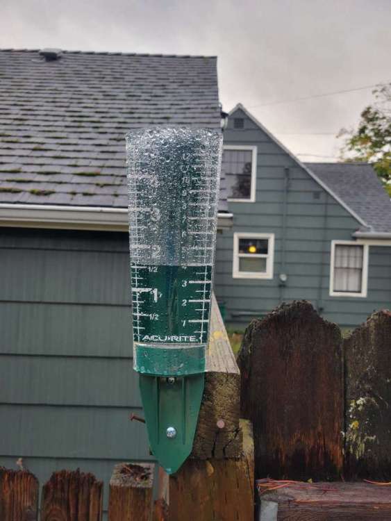 3 points
 -
Several of my buddies and coworkers knows how much I'm into weather and climatology. Pretty much been getting an onslaught of texts asking how bad the storm is because they "read on and heard on the news that there is a 'bomb cyclone' and that they're worried about power outages" -- had to ensure them that everything is okay and the storm is way offshore. This is the type of media sensationalism that we have to deal with and it targets a certain group of people who have no clue about anything about weather for clicks. It's also up to us to not fan the flames on social media by posting these type of maps without a broader context and explanation. This is a fight that I'll be with Scott all the way.3 points
-
My first "Frost Advisory of the season." Frost Advisory URGENT - WEATHER MESSAGE National Weather Service Detroit/Pontiac MI 302 PM EDT Sat Oct 23 2021 MIZ047>049-053>055-060>063-068>070-075-076-082-083-240815- /O.NEW.KDTX.FR.Y.0007.211024T0500Z-211024T1300Z/ Midland-Bay-Huron-Saginaw-Tuscola-Sanilac-Shiawassee-Genesee- Lapeer-St. Clair-Livingston-Oakland-Macomb-Washtenaw-Wayne- Lenawee-Monroe- Including the cities of Midland, Bay City, Bad Axe, Saginaw, Caro, Sandusky, Owosso, Flint, Lapeer, Port Huron, Howell, Pontiac, Warren, Ann Arbor, Detroit, Adrian, and Monroe 302 PM EDT Sat Oct 23 2021 ...FROST ADVISORY IN EFFECT FROM 1 AM TO 9 AM EDT SUNDAY... * WHAT...Temperatures in the low to mid 30s will result in frost formation. * WHERE...Portions of southeast Michigan. * WHEN...From 1 AM to 9 AM EDT Sunday. * IMPACTS...Frost could could harm plants and other sensitive outdoor vegetation if left uncovered. PRECAUTIONARY/PREPAREDNESS ACTIONS... Take steps now to protect tender plants from the cold.3 points
-
I believe Wet Candy was an adult film star back in the mid 1980’s, INCLUDING November 1985.3 points
-
If that's the case, they should just stop with the d8-14 outlook then. After watching them for many years, it's obvious that: 1) Their confidence level beyond d7 is never high enough in BN happening so they will just lean "safe". (aka warm bias) 2) They are often "caught off-guard" by cold snaps that Tom sniffs out weeks ahead of the Gov Gurus. (Tom's just a hobbyist, aka they suck) 3) As for seasonal outlooks, when's the last time the CPC called for a "BN" let alone "COLD/Frigid/etc" winter? The handwriting was on the wall back in 2013 and everybody BUT the GG's were going that way. (one of their worst ever botched seasonal releases)3 points
-
12Z GFS... slight shift to the northwest compared to the 00Z run.
 3 points
 -
Will have to get some more camping in late this month and next month.3 points
-
It has been a while since we have had a big time November storm. So I guess one could say we are overdue. Also while history doesn't suggest that it would happen (as past warm Octobers have not lead to heavy winter snow falls) could the warmer than average great lakes lead to heavy lake effect snows in November or December? well as always we shall see.3 points
-
It's great to see the teleconnections all start working in our favor and so me colder air looks to be on the way. Looks like many who haven't had a freeze yet certainly will by the 3rd including the first freeze for mby.3 points
-
Already looking impressive!
 3 points
 -
Its gonna get wild tomorrow at yby. Some of those storms could produce tornadoes and very large hail.2 points
-
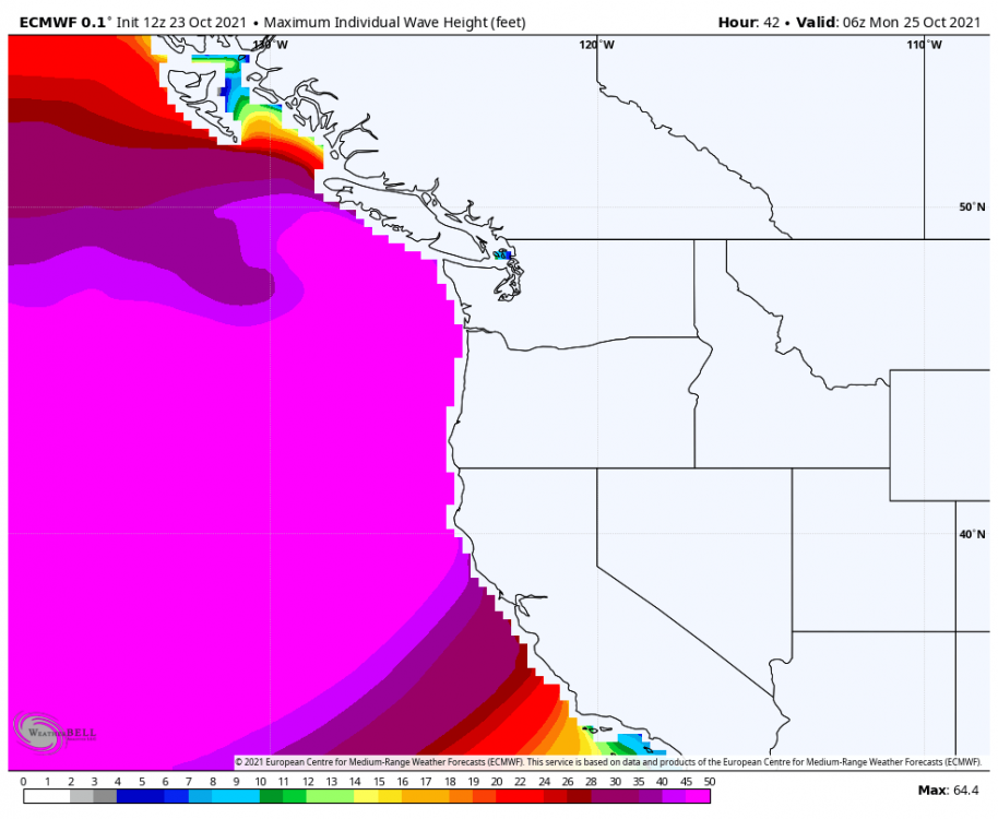
Looks nice for the coastal areas. A nice wave watching day.2 points
-
DTX. OMG, I need one of these during winter.2 points
-
Busy as in let’s get busy Arsenio Hall-style. I remember distinctly two occasions when it was SNOWING outside while AH was on.
 2 points
 -
Pretty cool.
 2 points
 -
How busy? Like engage in carpentry/build a deck and coat it in Thompson's water seal "busy"?2 points
-
Nice day for a cruise ship.2 points
-
Yup. People need to remember that going into a ridgy pattern now would probably be a good sign. The screaming zonal option becomes less likely going forward.2 points
-
Looks like the last couple GFS have things really drying out and turning mild by the end of the month. Just about 5-6 more days of rain and then severe clear.2 points
-
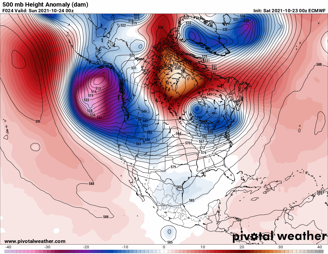
00z ECMWF - 10 Day GIF: 500mb Height Anomaly. 10 Day Rainfall totals. Dry Halloween. Setting up for retrogression?
 2 points


This leaderboard is set to Vancouver/GMT-07:00