
Leaderboard


Popular Content
Showing content with the highest reputation on 10/25/21 in all areas
-
Snow is just about to end. Dog is loving it
 15 points
 -
Tahoe airport this morning...
 10 points
 -
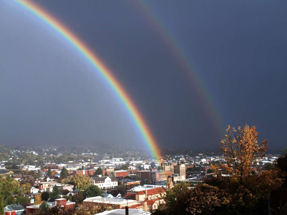
Rainbow memory from 10/25/2014. This was about a year and a few months before my better cameras, the contrast had to be fixed a little and the lighting.
 9 points
 -
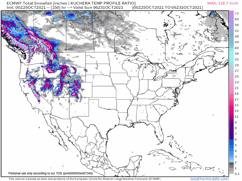
I finished with 2.32". I think that's a bit more than most models were showing for mby.7 points
-
I bet on Jameis to throw at least one interception. (Because of showers or something to keep it weather related)6 points
-
And then 10/26/2015.. Where's all my October fog lately?
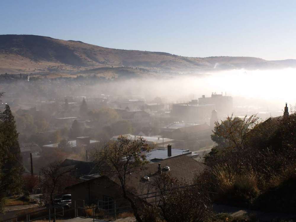 6 points
 -
I finished with 1.87". The defo band underperformed for Cedar Rapids as heavier rain kept rotating around us. A station down in Tiffin (Bud's location) is reporting about 2.9".6 points
-
0z EPS starting to sniff out the system on my calendar around the 7th (could be a day or so earlier)...energy coming out of the SW and tracking into the S Plains should have some winter implications for the central Sub. Snow chances on the rise for a lot of members on here. Quite the pattern setting up for the first part of November. Quick note, models will come in an hour early on the 7th (2:00am local time)...we may be tracking a wintry system during this time period. Perfect timing, ay?? "Heartland Chill"....Brrr, I just got the chills looking at the new data...opening week of the month a stark difference to what we've been used to last month...
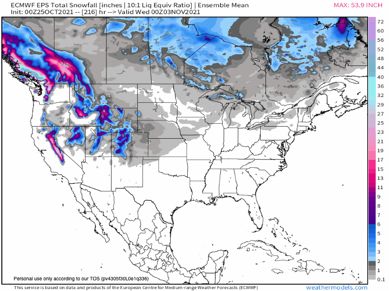
 6 points
 -
Fair enough!
 5 points
 -
We had somewhere around 7" of rain yesterday. It switched over to snow around 2am. We have about 8" of heavy Sierra cement sitting on top of flood waters. Still nuking outside with a temp of 34F5 points
-
4 of them, 6th significant storm to effect the middle of the country since Oct 6th and number 7 is on it's way. The storm you predict for the first week of Nov, could be another slow moving soaker with a cold component to it.5 points
-
Just as I was pulling up to my driveway a minute ago, I saw this huge flash of lighting! This storm is dynamic...rain is blowing sideways, leaves blowing off the trees, branches everywhere...man, what a storm! Not to mention, but this defo band has held together all the way from OMA/LNK and not letting down. My curiosity keeps me wondering what this storm would have done in the colder months ahead...what # storm is this so far this season that has delivered such dynamics??? I think its gotta be 3 or 4...and we ain't done yet for the week!5 points
-
A new month will bring forth an entirely different North American 500mb pattern. Pop goes the western ridge, nature shall unleash the "Fridge"...right on cue, Nov 1st opens up with a good chance of an early season Arctic Chill down the Plains and then bleed east into the GL's. First snows are increasing in likelihood over the GL's region, but maybe also near @CentralNebWeather... 0z Euro...
 5 points
 -
Delightful weekend coming up!4 points
-
Please take football banter to appropriate thread. Thank you.4 points
-
Come on Phil. Admit you are misspoke. You said storm after storm... About a model run that shows no storms hitting California. LOL4 points
-
The 8-14 day from last week that was normal to above normal has now switched in the 6-10 day to the following. No wonder the Heidke skill scores are so bad - it's more flip flopping than a politician.4 points
-
Euro showing some snow to start out the month for parts of Nebraska.4 points
-
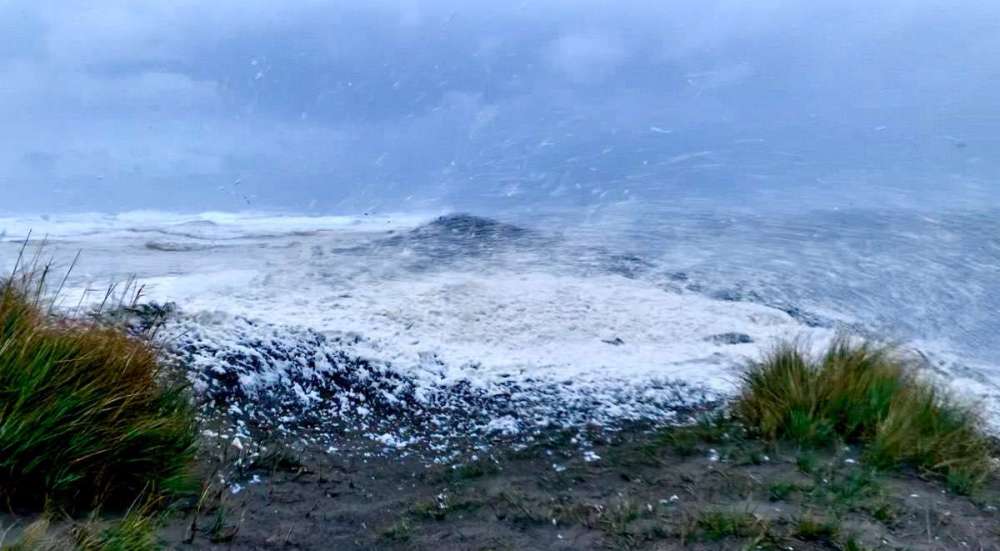
Heavy bands keep missing me this morning. Still plenty windy down on the beach. Felt like 35-40 sustained with higher gust. Sea foam was cruising as well!
 4 points
 -
Good blog today from Lezak, he discusses this years pattern so far, the storm ongoing right now and the upcoming storm later this week. https://www.kshb.com/weather/weather-blog-hurricane-rick-heads-our-way-a-major-storm-develops4 points
-
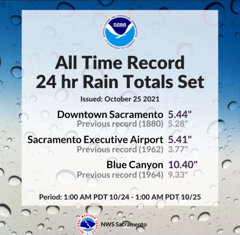
That 1880 storm in Norcal actually occurred in late April, at the tail end of another insane strong Nina storm season in 1879-80. https://www.wunderground.com/blog/weatherhistorian/the-great-california-storm-of-april-1923-1880.html4 points
-
My FB memory from 2016! It didn’t turn out as well as I was hoping for but the little slushy events almost every weekend in my area in December and even parts of January were fun.
 4 points
 -
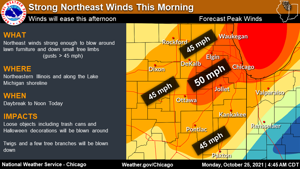
LOT updated their wind map...yup, it certainly paints that kinda picture outside right about now. Holy smokes is it gusty!
 4 points
 -
Ended up at 2.69" IMBY. Looking at radar, thought we'd for sure hit 3"+, but the heavier storms that kept on redeveloping stayed south of us from Lincoln on east, so ended with mainly just light to moderate rain after we hit 2". I chased in Missouri yesterday and probably something I won't do again, unless it's a slam dunk tornado outbreak. Initially wanted to play out in the warm sector and just south of the warm front so I drove to Columbia. Those storms along a prefontal trough or convergence storm all lined out though. Meanwhile I saw the storms form right to the east of the low pressure and they looked to be lining out really fast near and north of St. Joseph, so even though they had a couple of tornado warnings with them very quickly, I didn't make a break for them right away. After a while being near and just east of Columbia, I checked back on the storms and saw now just 2 individual cells remained of the line and they were both tornado warned. I made a break back to the west figuring this will work out since I'm heading in the general direction of home and the storms were moving at me at 40+ mph so I'll get to them quickly. I did get there just around the time Purdin was being hit, but bc of the terrain in that area, plus it being a rain wrapped tornado, I couldn't see anything. That's some of the most winding, hilly, forested area I've ever chased in before. 30 mph almost seems too fast to drive safely on those roads! I called the chase off about 6p and made it home back around 1030p.4 points
-
October 1880 is the most similar to this though. That was the all-time record up until yesterday for most locations in NorCal. Interestingly enough, the longest dry streak on record in Sacramento was also set in 1880 before this year. Huge winter followed for the Midwest and Plains. https://weatherology.com/trending/articles/Long-Winter-Eighteen-Eighty.html4 points
-
I finished with 3.07” what a soaker could be fun when it cycles through.4 points
-
Local wx app says close to 2.5" of rain has fallen with more to come throughout the day. This has been the multi-faceted system as now the winds are gusty out of the NE. Finally, a real Autumn storm that has targeted the MW/Lower Lakes region. The furnace has been kicking on more often than not overnight. IMO, this week of wx will go down to me as the week when "endless summer " flipped into real autumn.4 points
-
Sacramento official 24 hours totals yesterday was 5.44”. Broke the record from 1880. Unreal. SEA’s wettest day all time was 5.02”3 points
-
I’m in the blue!3 points
-
Can’t wait to see all these storms slam CA3 points
-
Looks like the gusts topped out in the mid-30s mph late in the day here. Not the 40+ we saw in Sept. That's what made the Equinox storm such a rarity for time of year and non-tropical at that. Nice storm nonetheless and seriously could've been yuuge in winter. Seems we finished right at the forecast if not slightly better. KDTW = 2.12" KYIP = 2.10"3 points
-
18Z Euro for mid/late week has similar jack zone as this past weekend.
 3 points
 -
These are the folks cancelling winter, too, so keep that in mind. Lol. Anyone wanting some forecasting experience, November will be the gauntlet down here and up by you. Going to get wild.3 points
-
Too much reliance on models and not enough forecasting. They look lazy.3 points
-
OMX thoughts on mid/late week system.
 3 points
 -
Perhaps temporarily. Regardless, big-time blocking is there and that's good to see. Doesn't seem like a static pattern.3 points
-
Breezy. IMG_5325.MOV3 points
-
Good thing California just got a whole bunch of rain/snow otherwise this upcoming pattern would have been an ugly fire situation once again.3 points
-
Another nice soaker for CA on the GFS.3 points
-
Can't draw it up much better for you than that. Maybe it will be a little whiter in 50 days or so for ya!3 points
-
Chilly mornings and mild afternoons coming up...3 points
-
Looks like it might be white up here next week...ready to roll!!!3 points
-
I did not check on my rainfall amounts so far, but it is definitely more than 1.50" and counting. Mby should receive b4 its all set and done near 2.50"+.3 points
-
Man, its very stormy outside. Radar looks loaded w moisture. I hope Ma Nature develops these storms, come Winter.3 points
-
Almost ready! Christmas lights up later this week and snowblower on the tractor on Sunday. Then bring it!

 3 points
 -
18z? Doesn't seem like we are looking at the same model... 12z was wetter, was that what you meant? 18z looks a lot more climo...2 points
-
Snowing in Tahoe. 2 months until Christmas.2 points
-
I don't know, margo?2 points


This leaderboard is set to Vancouver/GMT-07:00