
Leaderboard


Popular Content
Showing content with the highest reputation on 02/12/22 in all areas
-
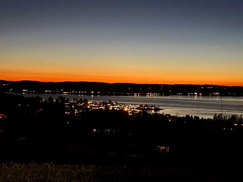
Twilight at 6:30 today.
 7 points
 -
I guess it's because the dynamics for cold rain here are basically climo. Without raging southerly flow or a decent Arctic airmass, it will pretty much always precipitate cold rain here in the PNW. Where you live cold rain is associated with snow either immediately to your north, or immediately above your head. Snow in those situations is a tangible, realizable threat. Here in the PNW we won't really think of cold rain in terms of "oh, snow is immediately above me!" It's just climo; it is the way it is. We aren't "missing out" on as much as you do when it's raining and 40°F. That's just the general nature of a continental vs temperate climate. The dynamics of rain vs snow are basically "boom or bust", rarely in between, at least here at sea level where we miss out on most marginal events. "Cold rain" is dynamically so different between our two climates that comparing them is a stupid game. Zonal flow here is just climo, but especially ecologically beneficial. Hard to convey that difference.7 points
-
unsustainable sources7 points
-
There is no doubt about that. And how wrong I was on a N shift, but to my defense the system is not wrapping up like it was a day or so ago, but still - bad call on my part-- I should've followed the trends of the winter. This thing keeps trending the way it is (weaker and SE) -- other than lake effect off Lake Michigan - a rather non-event. Hats off the CMC (again this winter scoring a coup) for leading the way...6 points
-
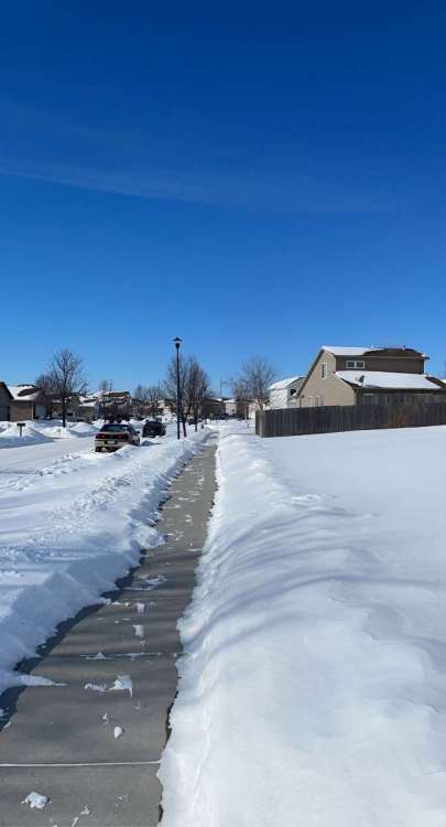
CentralNeb posted some pics yesterday, but yeah it was a different world last Feb. This time last year Lincoln was in the midst of a 10 day stretch where the highest temp was 13, nine of those days were in the single digits or lower. Snow wasn't crazy deep, but at least around a foot coupled with those temps turned Lincoln into northern Minnesota for some time. Of course my friends/roommates/coworkers all think I'm crazy for reminiscing about this time These pics are from the afternoon of Feb 15th, temps were about -6 at the time (Also snapchat pics look way worse after pasting them somewhere else, I need to stop using it but I always lose stuff in my iCloud lol)
 6 points
 -
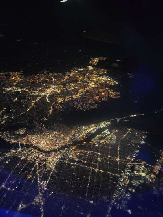
Just flew over a sparkling Rose City on our quick PSP-SEA flight. So nice when planes are landing from the south at SEA... just slide right in without having to circle for an extra 20 minutes.
 5 points
 -
February 12 is snowstorm day. Three separate 6"+ snowstorms on this day here in the last few decades (1990, 1995, 2021). No such luck today, so I went to the closest snow I could find and hiked up Silver Star Mountain. Still a couple feet iced over on much of the trail, so definitely needed the poles and microspikes. But there were still a number of surprisingly elevated clear areas where it was more exposed to the sun, even up at the top.5 points
-
I remember when it used to actually be FUN to watch models and track the storms. This year it's been the opposite. I've had FOUR different storms showing 10 inches or more on models for days, only to end up with 3 each time. Ridiculous5 points
-
Caught this pic last night and forgot to post it.
 5 points
 -
A nice wonderful spring-like day!! Looking forward to many more of these to come. My body and mind is ready to leave “winter” (a week’s worth? Lmaooo) behind.5 points
-
I used to always be concerned with storms going NW of me. Not this year.5 points
-
06z wasn't terrible5 points
-
Nice house, especially with the 21 acres! Carpet in front of the tub can be easily remedied, though we had that in our house in Oregon, and it actually wasn't too terrible. We used a bath mat with a rubberized bottom and draped it over the tub when it wasn't in use. It never got too saturated or funky. Also, seeing that house made me realize that we could conceivably do something like that now. My wife starts a job on Monday that is 100% remote, and my job can be 100% remote. That said, I really don't want to buy with the market being what it is right now....I'll just keep paying on what I've got.4 points
-
Clearly ridging and dryness with zero new mountain snow for weeks on end is far better.4 points
-
As someone who lives at sea level (not 1600ft), zonal flow does NOT, in fact, suck.4 points
-
Last year at this time I was NOT sitting on the patio furniture as I am now.4 points
-
It comes from hoses and pipes, dingledork.4 points
-
Oh no GFS, you aren't gonna rick roll me again.
 4 points
 -
I’m far more excited for tonight’s little clipper than this storm. Short term models are showing a nice stripe of 1 to even as high as 4” through eastern Iowa.4 points
-
GFS is lame. Another storm that doesn’t get its act together until it’s well east of here? Shocker.4 points
-
This is a trending turd4 points
-
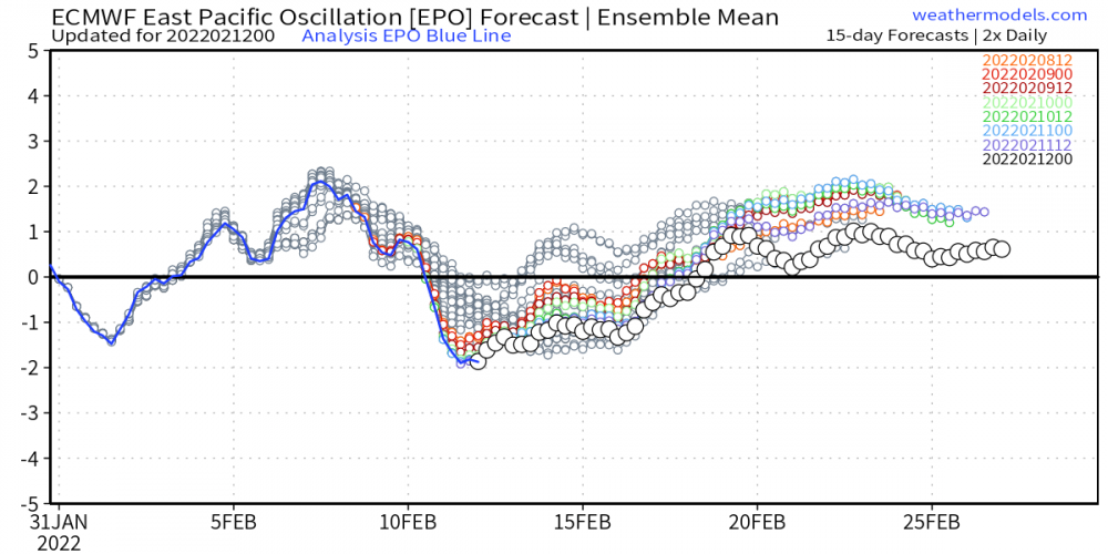
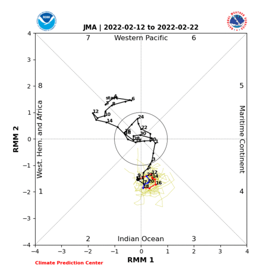
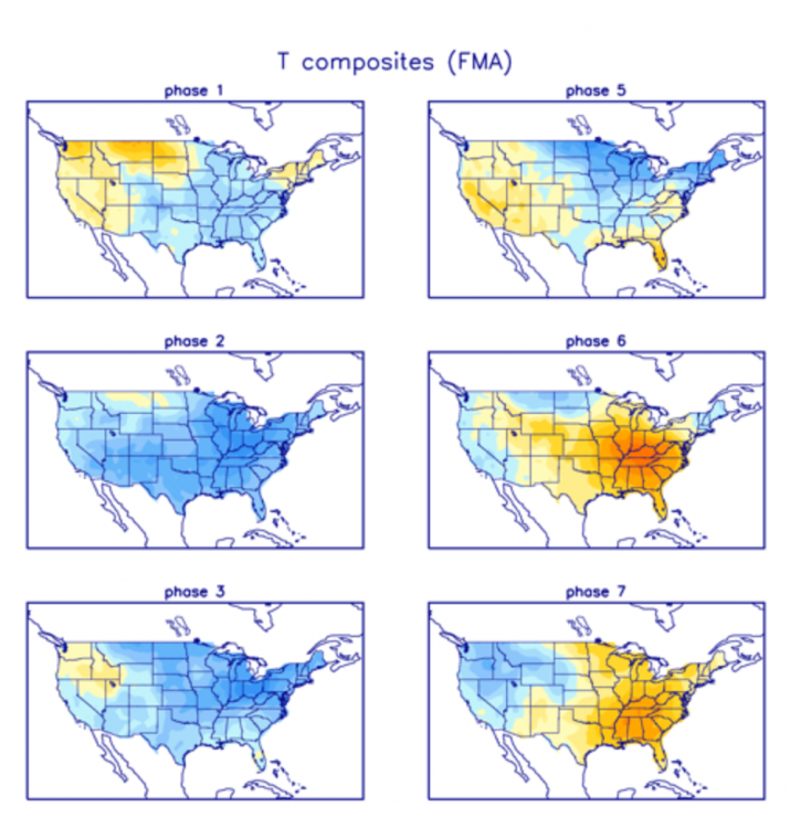
Hmmmm, I'm starting to ponder on the idea if the modeling hinting at the idea of Spring to be a "head fake" or not later this month. Tonight's 0z EPS is starting to show some real interesting members for the next big storm on the calendar between the 23rd-25th. At this range all I'm seeing is a very wet and potentially wintry set up that may turn into a prolonged event. Given the teleconnections at this time period I'd suspect to see a set a pattern where the SER is present and a frontal boundary draped across the central SUB. What has perked my interest are the trends off the EPS that show a large portion of the central SUB with more members showing the snow potential. The pattern will shift towards a more traditional SW Flow aloft for the remainder of the month post 23rd and line up with the idea of a wetter...(snowier ?????)....pattern for the central plains members. Let's take a look at the East Asian Theory and how this may be a better tool right now to predict where this next system may track. There is a potent trough that is forecast to slowly track through central Japan (perfect track for the central Sub)....strong blocking to the north which suggests a Canadian HP should be present...but how strong will it be is the question??? The EPS has been slowly backing off the +EPO in the extended (bias noticeable)... SER pattern is almost a certainty....this would add more validity to the LRC's active pattern during its wetter cycle. So, as we track our storm system for mid next week, there appears to be a lot of model contradiction in the extended. None more so than the battle with the MJO signal during the Week 2 period and beyond. The JMA is now suggesting a stalling in Phase 3...I'm waiting for the new run of the CFSv2 to come in and if it shows any signs of the Phase 3 idea, then I believe we still have a lot of Winter left on the table. Who does that include is up in the air ATM but rest assure, it'll get more active across the board. I always felt that it was going to be the eastern SUB to benefit during the 1st half of the month, then eventually the western Sub would start to cash in. Let's see how this evolves. Just saying, but the CFSv2 is showing some wild individual op runs for MAR...Phase 3 temp anomalies for MAR below...if the JMA wins again in the LR then buckle up bc MAR can produce some wild weather in an environment where the clash of Winter & Spring could dial up some Blizzards. Gosh, could we just track a couple true Wound up Big Dogs before winters over???
 4 points
 -
Installed the new garage door opener today.3 points
-
Rock-Paper-scissors for the closet.3 points
-
Let her have them. Is there really any other option?3 points
-
My gf is trying to claim two closets in the new house just for her clothes….. this will be a fun discussion. Any advice guys3 points
-
0z GFS and ICON wouldn't need much a nudge north to give KC a nice snow. Good hits from mby up to southern Michigan.3 points
-
It was just starting to accumulate one hour from now a year ago: What a weekend that was!
 3 points
 -
Pretty discouraging to see the 18z return to a strong ridge in the long range but at least the ensembles look better Have kind of a sinking feeling we could be fighting off a stubborn ridge just to our west most of early spring, just like last year, but would love to be wrong
 3 points
 -
Most zonal flow is just rain here too... But we need it...3 points
-
Your extreme over-reactions to very popular and pleasant vacation spots is hilarious. Always amuses me.3 points
-
Next time someone mocks me for appreciating zonal flow remember our current nightmare. I don’t think anyone of us imagined this winter would turn out so poorly.3 points
-
64 at SLE, 62 PDX, 58 at EUG. Could have a wild spread in EUG today since they got down to 27 last night.3 points
-
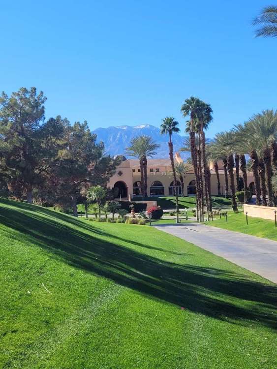
Live view of snow on San Jacinto from Palm Springs...
 3 points
 -
over it still have a sneaky suspicion we'll get hammered with something late season3 points
-
Top 5 Crappy winters of all time in my book! Any ideas to what December this year will look like?3 points
-
Your reasoning made sense. It's just the way it's gone this winter.3 points
-
12Z ECMWF is actually cold enough for lowland snow by day 9.3 points
-
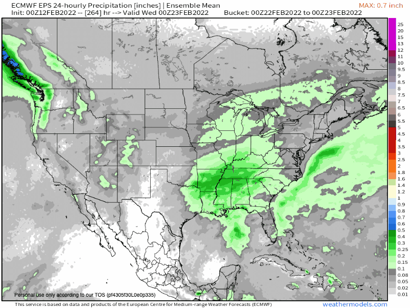
Models seem to be gradually trending wetter and troughier last half of feb hoping to see that keep up3 points
-
1 year ago this evening it started snowing.3 points
-
That's just it. It's been cold, just no real snow. When it did warm up we got 3 inches of heavy wet snow yesterday. Now it's 15 degrees and everything is sheer ice. Now it's going to warm up, rain, then change to wet snow, end and everything will just be ice again. I want one consistent meltdown, then wouldn't care if it snows again. I expect it to snow again, even maybe a decent event by the end of February. A nice fresh snowpack I wouldn't mind.3 points
-
Call it LRC or just the "seasonal M.O.", but yeah it's a real phenomenon. Fantastic when you're in the jackzone constantly, but just horrible when you find yourself in the dearth zone. Unless it's a clipper, my place this winter is riding the southern edge on all these SW flow storms. Can't break that.3 points
-
Just wow at this point.
 3 points
 -
This looks like a repeat of the GHD storm. The model runs are remarkably similar with a further north track several days out, to shifting south and more progressive. It’s looking less and less likely that we’ll see much of anything up this way.3 points
-
Did someone mention spring?3 points
-
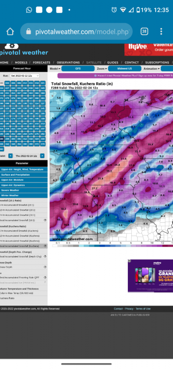
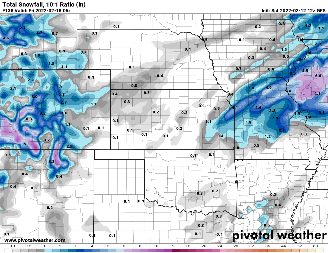
EAX mentioning the potential for blizzard conditions in KC in this mornings AFD That leads into the strong storm system models continue to show track across the middle of the country late Wednesday through Thursday. The GFS and the ECMWF continue to show good agreement with the ECMWF still a bit slower and a bit more south with the 500mb vorticity center at 12Z Thursday. The GFS also has more of a negative tilt sooner which induces stronger lift and a more pronounced deformation zone, that sits over eastern KS and western MO Thursday. The ECMWF is a little later to take on a negative tilt leading to a deformation zone that is further east of the area. This difference in the position/time/angle of the upper trough also affects the surface wind fields. The GFS produces a stronger pressure gradient further west and would result in near blizzard conditions over the forecast area if it verified. With the later/more easterly negative tilt of the ECMWF, the stronger winds are further east as well. That said, there`s still a lot of uncertainty with some critical aspects of this storm. The track of the storm, the thermal profile, how quickly temperatures cool are still very uncertain at this point. Overall, this system has the potential to produce accumulating snow, potentially heavy, across portions of KS and MO, combined with strong and gusty winds.3 points
-
This is going to turn into a GHD joke real soon. Bring on SPRING!!
 3 points
 -
06z NWS Blend...
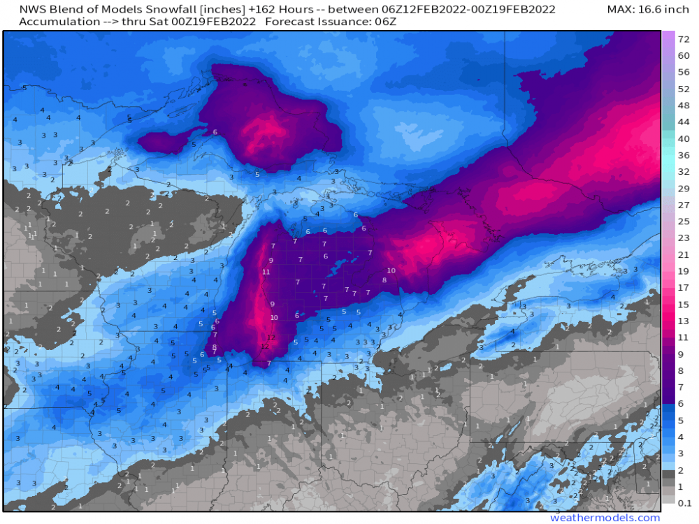 3 points
 -
0z GEFS...
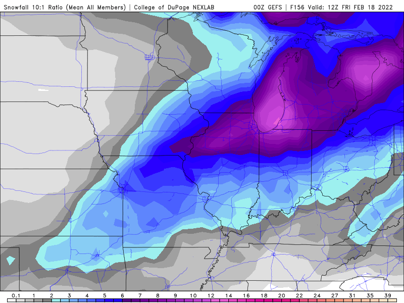
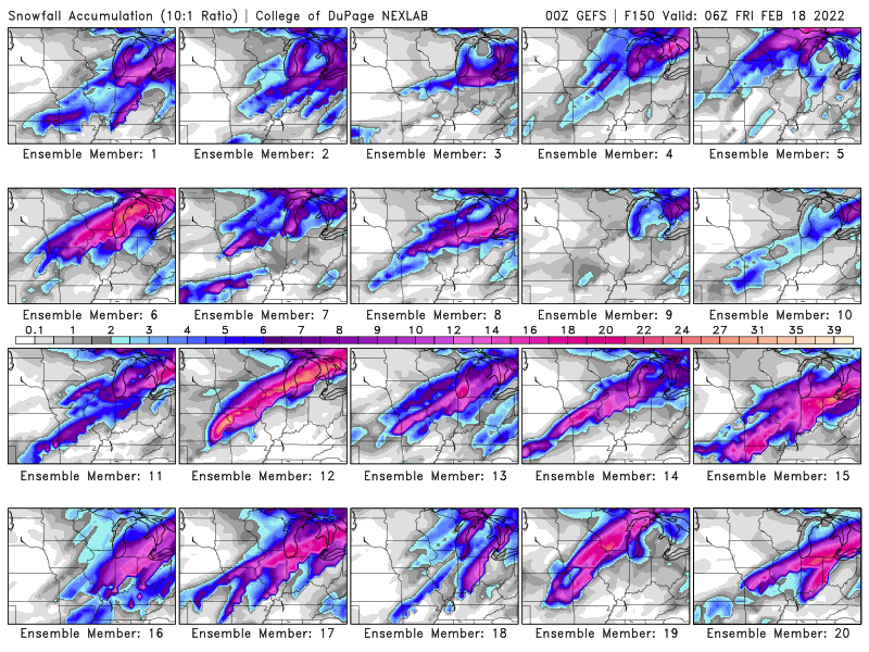 3 points


This leaderboard is set to Vancouver/GMT-07:00