
Leaderboard


Popular Content
Showing content with the highest reputation on 02/28/22 in all areas
-
I know you know this, but it bears repeating for myself and others that we could get 200%+ of normal rainfall over a winter, but if it all fell at an average temperature of 55F in the lowlands with freezing levels 6,000'+ we could still be in terrible shape for summer. I think the fact that the Cascades currently have average to just below average snowpack despite how wet the winter has been shows that pretty clearly. Similarly, it it was wet in November it could probably be completely dry throughout December-February (with such low levels of solar radiation) as long as the following months put enough snowpack in the mountains to bring us to average and we had a normal spring/summer. Of course that wouldn't bring a very good ski season, but in terms of everything else that matters it would probably be fine. I think people see a dry Jan/Feb (yes, except for a couple days that brought us up to normal on those months) and get worried because that's when most of our precipitations normally falls and we're unsure whether March/April will be wet enough to make up for it. And based on the last couple summers, even having average to above average snowfall in the winter has still caused problems by the end of the summer. So basically, has this been a dry winter? Technically no, but we did just go through the third driest 1.5 month (45 day) period during the winter on record at SEA (behind 2009 and 1988) and if the rest of the spring was drier than average we would be in trouble.6 points
-
We may not be done with Arctic air.6 points
-
I just hope Joshua is happy.6 points
-
Dry evening here and warm! The frogs are singing like crazy tonight!5 points
-
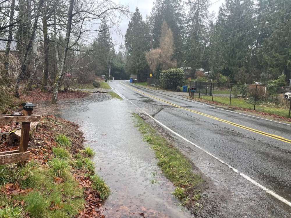
It has been a long time since I have seen a flood warning for the Puyallup river, pretty crazy stuff.5 points
-
Omaha hit 70 today for only the 5th time in February in the last 20 years. Four of those times were in 2017 when we were also under a severe drought.5 points
-
Made it to 69.6 today IMBY with a light breeze. The humidity is down to 14%. Should hit the 70s tomorrow and Wednesday too. It's supposed to cool down Thursday with a backdoor cool front to near 50, but based on today's GFS should warm right back up into the 60s and 70s Friday and Saturday.5 points
-
66 here as of 2:20 PM. It really did a number on our snow...., oh wait, we haven't had any this winter. Upper 70's on Wednesday.5 points
-
Could be looking at approaching some 24 hour records for February in some places. Heaviest rain also looks to coincide pretty perfectly with the calendar day.5 points
-
Trudeau wants to play too
 4 points
 -
Not only that, they have a shot at top 5 wettest days ever. 1 10/20/03 5.02” 2 12/03/07 3.77” 3 11/20/59 3.41” 4 11/06/06 3.29” 5 12/20/19 3.25” 6 2/8/96 3.06”4 points
-
3.01” for the day. Heaviest rain band is NE of here now plenty of time to go though.4 points
-
Chill Jesse. They'll find you.4 points
-
Made me think of this lmao
 4 points
 -
4.70 inches so far for this event - just wet.
 4 points
 -
Better for water supply to get average rain distributed throughout the month4 points
-
First major rain @ the new house. We’ll see If the roof has a leak or not.4 points
-
Was hoping we’d over perform this week and already off to a good start. Sitting at 50 currently and should rise a few more. Sun feels amazing and getting me excited for BBQ, boating and other outdoor activities.4 points
-
We are doing a road trip down to the SW in mid March wonder if it could be cold and snowy at times in Utah and NM4 points
-
Haven’t seen the radar like this over Portland for awhile over .75” on the day and counting temp finally warmed up to 55 after a 44/36 day yesterday
 4 points
 -
Rainstorm total 2.24 Current day .90 Current rain rate .16 Conclusion : wet! 50*4 points
-
I suspect predictability will be very low over the next few weeks. #SSWing
 4 points
 -
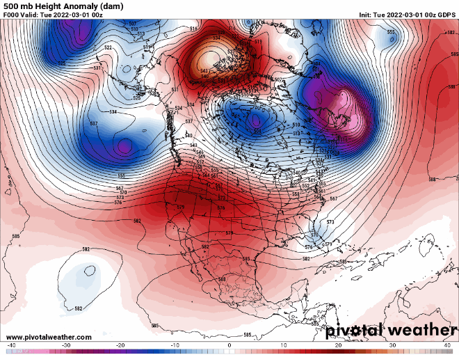
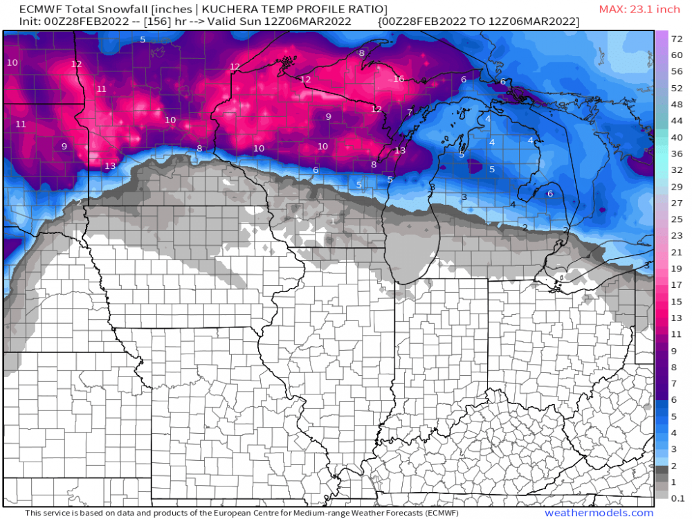
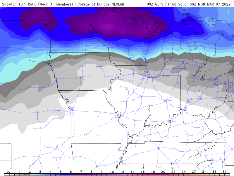
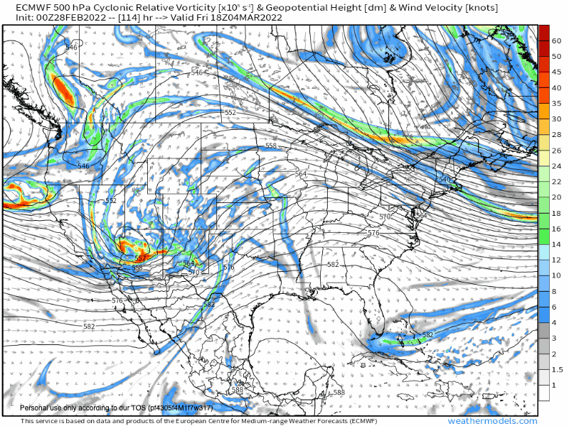
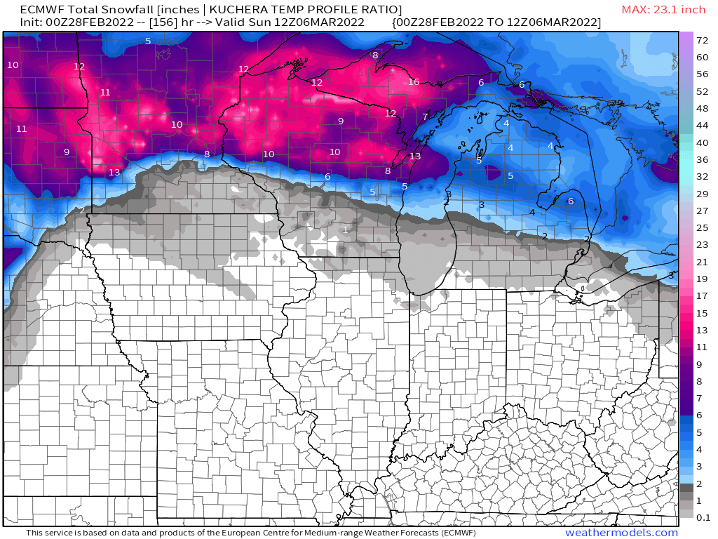
The first, in what will be a series of waves coming out of the SW/4 corners region, will be an elongated CO Low that ejects out into the Plains and tracks towards the W GL's region. How strong will the blocking be up north? This first system looks to take a track into IA and then thru the GL's. There will be a potpourri of precip types from Heavy Snow, ICE, Storms and a good amount of rain. Let's discuss....#SWFlow 0z Euro Op...a little warmer than the GFS up in the Northwoods but still dumps a good amount of Snow with this 1st system... 0z GFS showing a stronger HP Block up on top.... 0z GEFS.... 0z Canadien... Meantime, those south of the track are going to warm up quite a bit and get a taste of Spring....doesn't last long but I'm sure it'll feel pretty darn good! Here's an animation of the 500hpa vorticity off tonight's 0z Euro...just look at the complexity of all the pieces of energy targeting the West Coast....busy times tracking ahead... 0z EPS...farther south with the snow mean thru Saturday...
 3 points
 -
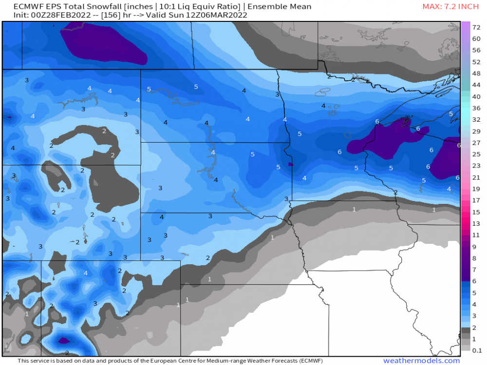
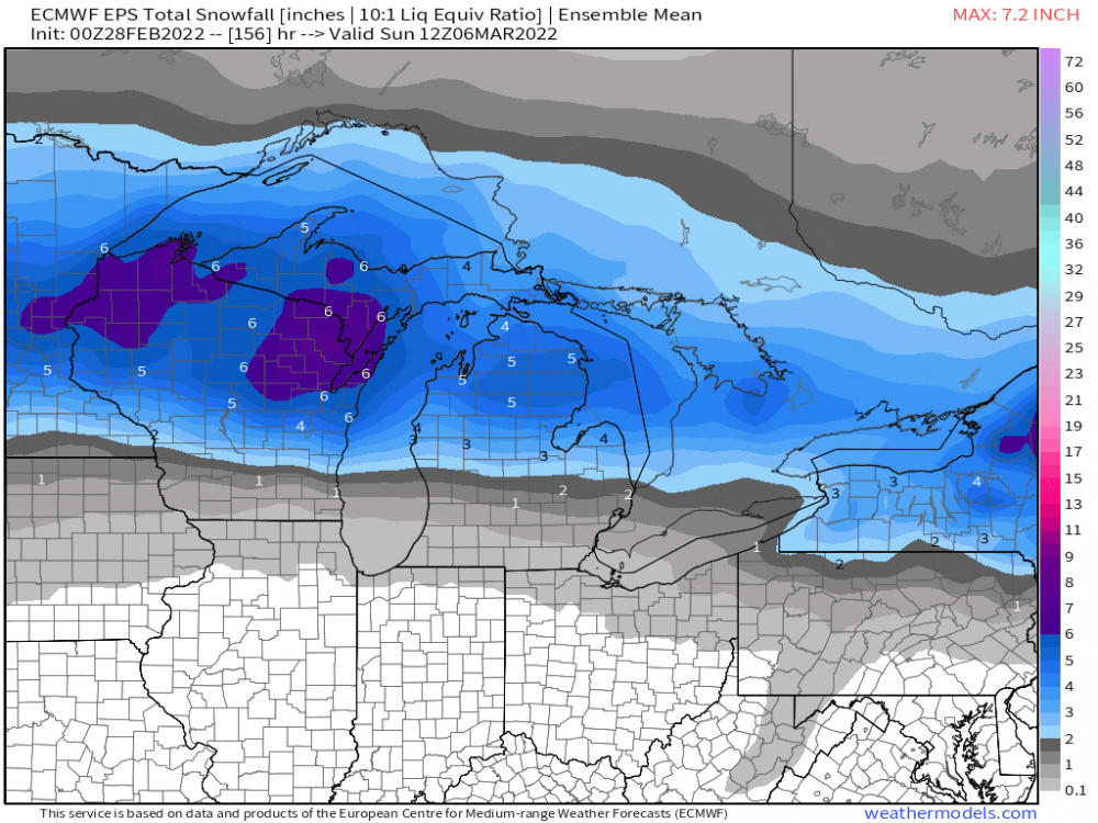
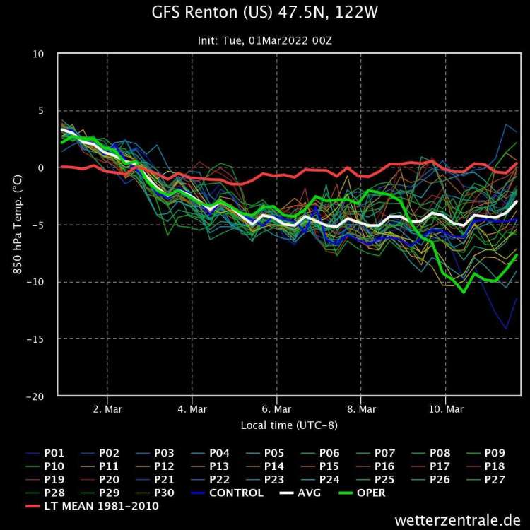
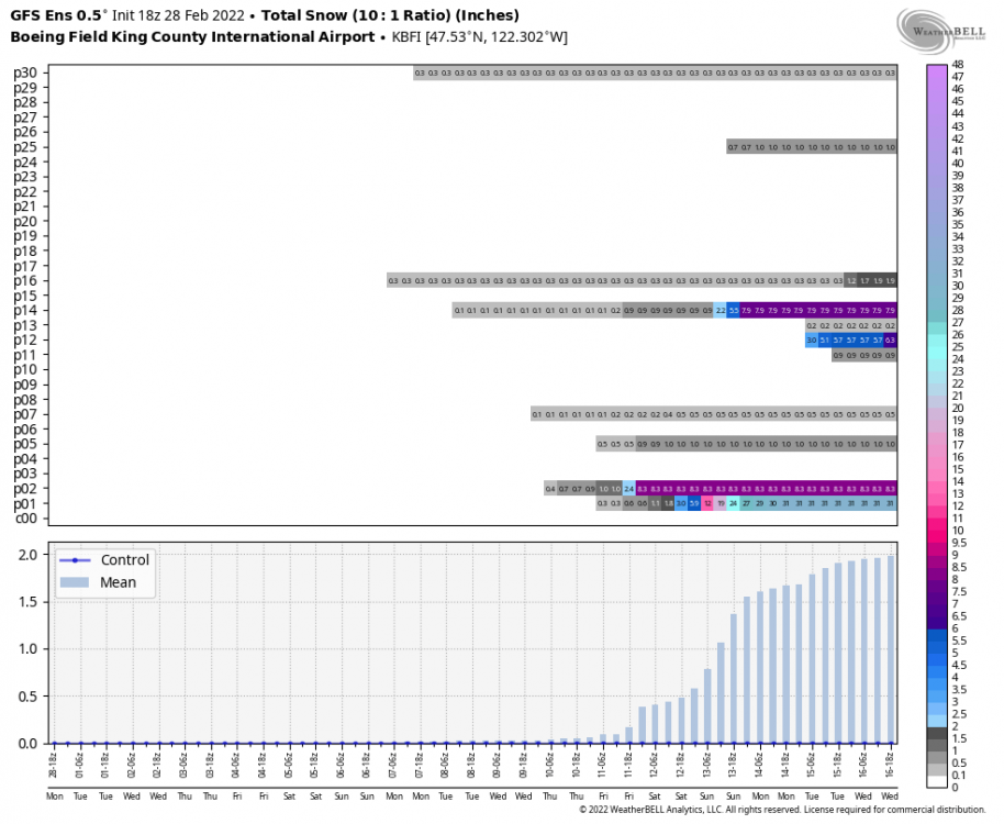
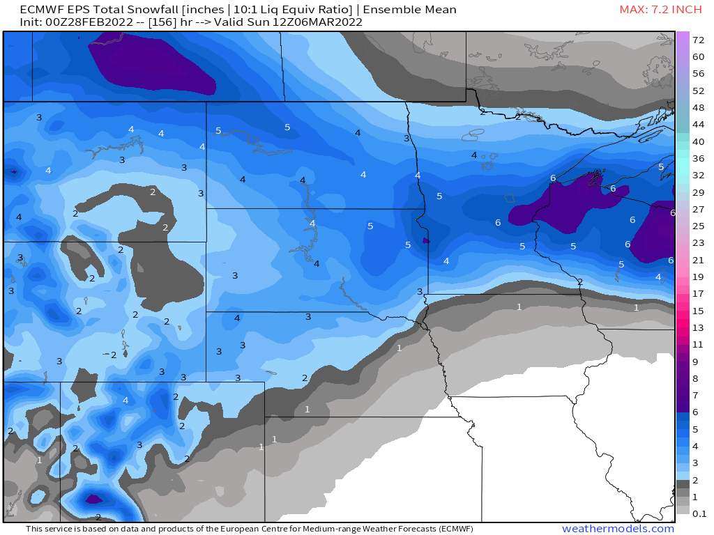
Lowland snow on day 10 per the 00Z ECMWF...
 3 points
 -
Euro gets there at the end. Wonderful progression3 points
-
Here’s GEFS so far. OP has a few pals
 3 points
 -
5.33” so far for the event, 3.65” since midnight. Goodbye planter boxes.
 3 points
 -
Seattle just needs .3 more inches for the record of wettest day in February. Will it make it? Possible...3 points
-
Looks like the rain band is moving back in to the Portland area now 57 degrees after a high of 593 points
-
Recorded a mere trace of rain in the last 36 hours. No measurable precip since the 21st imby and that was snow at 0.01 of liquid precip. 1/2 of snow. Cold last Tuesday and Wednesday with a high of only 17 on Tuesday and 26 on Wednesday.3 points
-
Has rained really hard the last couple hours. 2.90” right now. Since 2005 we’ve only had 2 days exceed 3” of rainfall. 3.33” on 11/6/06 and 3.33” on 1/7/09. Will see how close we can get to those before midnight but wow really impressive amount of rain in the last ~30 hours.3 points
-
2.52 inches so far today. Now at 4 inches for the event.3 points
-
Powers out.3 points
-
18z GEFS was go big or go home. mostly home. but a couple were smoking/snorting/injecting/freebasing/eyedropping/etc the good stuff!
 3 points
 -
Video I took of a nice urban stream forming while walking some pups today. IMG_1500.MOV3 points
-
Temperature ranges have been getting even crazier. I just noticed that LNK bottomed out at 8 yesterday morning and hit 59 by the afternoon. Almost identical today, except 10 degrees warmer. 18 in the morning and it's currently 69. Humidity has also bottomed out at 10%. I guess I don't really have any complaints that haven't already been dwelled on, but it's amazing how the situation continues and worsens.3 points
-
The Euro mostly won. We are expected to only reach the 30s Thursday behind a front before we climb back to the 40s Friday and 50s Saturday.3 points
-
Looks like SEA has set a daily rainfall record and its not even noon yet... surpassing 1.46 inches on 2/28/19723 points
-
True 2008 is a good example of a relatively recent one that averaged cool MAM but was more dynamic with a continental flavor3 points
-
PDX up to 1.13" on the day as of 9:53. Good chance they break the record of 1.66" set back in 2011.3 points
-
Closing out meteorological winter. NWS Kansas City @NWSKansasCity Today is the last day of meteorological Winter! Winter 2021-2022 will go down as tied for the 22nd warmest out of 134 years. It is the 8th driest (1.96" of precip) on the 134 year record. And, it is the 52nd snowiest (15.4") on the 134-year record.3 points
-
This wet season has been a tale of two parts, from a very wet September through early January, to a nearly record breakingly dry 50 day-ish period since. As for temperatures, it's been refreshing to see deep Arctic air in December not immediately answered by torching. Got pretty used to that since 2012. This has been the coolest winter up this way since 2016-17, and even that winter torched hard in November. The one warm month this Sept-Feb wet season (Nov) just edged mild, not very torchy. La Niña has lived up to its name here.3 points
-
NWS Hastings morning disco:: In addition...the flow will become more active as several disturbances will round the base of the trough across the southwest and cross the plains. With the cooler air then in place...could actually see a chance for snow across the local area this weekend and into next week as this more unsettled...and potentially beneficial period...is expected to continue into next week. Models have been hinting at this for several days and consistency continues to increase giving the hope for some much needed precipitation to the local area.3 points
-
For sure. This is the big SSW we've been waiting for. I would have to call this a pretty solid winter if we get another round of significant cold in the next couple of weeks. About as good as you can get without January contributing anything in most locations.3 points
-
When you think about it this regime we are in is truly remarkable. We go for almost all of February with almost no rain and then we get a month's worth right at the end. Then after this we go right back into chilly and blocky. This might be a pretty interesting year.3 points
-
00z Euro looks good next week3 points


This leaderboard is set to Vancouver/GMT-07:00