
Leaderboard


Popular Content
Showing content with the highest reputation on 06/28/22 in all areas
-
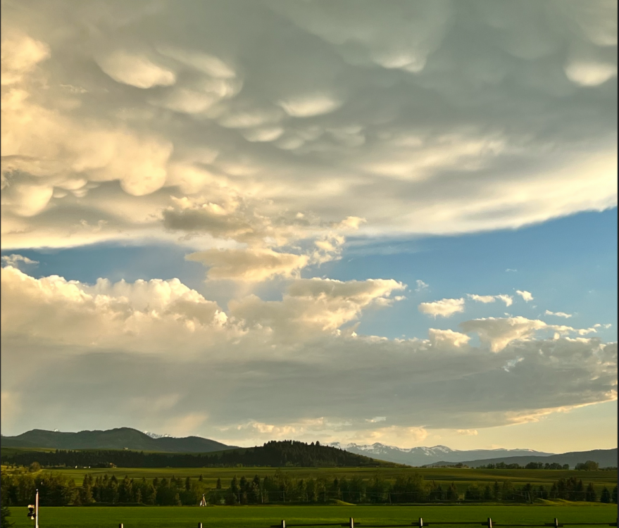
Couple of severe warned storms with 75+mph winds narrowly missed me this evening which is just fine by me! Still put on quite the show. Still a decent amount of snow in the mountains as well! And to think the first snow up there usually arrives again in just a short 6-7 weeks!
 15 points
 -
Very enjoyable evening.
 9 points
 -
Something for everyone the last two days.
 8 points
 -
This is hard to understand because the numbers are not football jerseys.7 points
-
28 degree 24-hour temperature change. Impressive.6 points
-
Seems like a sprawling central US ridge is going to be a main feature moving into mid summer. Hopefully we will stay on the comfortable periphery more often than not.6 points
-
Do I sleep? Yes, sometimes. Little man wanted to party early this morning. Now he is back to sleep so might as well get some things done before he gets up again. Currently 50 with clouds. There are some breaks in the layer though, should be a nice day.6 points
-
Here comes the marine layer cresting the ridge...
 6 points
 -
Just a slight difference…
 5 points
 -
Today will top out at 64F at KSEA, a 27F drop in high temps from yesterday. That is a record for 90F days in June! A true summer crash.5 points
-
For someone who reads the forum often you’d think you know about how some recent summers have played out.5 points
-
South Lake Tahoe also nearly burned down last summer so maybe it's a blessing??5 points
-
5 points
-
Sunshine Village in Banff is opening for 6 days of summer skiing through the long weekend. I read it was only the 2nd time in a century that has happened5 points
-
GRAMMAR POLICE INCOMING!!! Couldn't care less* Could care less implies you care.5 points
-
The man has 5 kids including a baby. Real sleep left his life a long time ago.5 points
-
Yeah, 70°F with full sunshine and a 15mph breeze sounds AWFUL.4 points
-
To be fair there aren’t many weather patterns you guys have gotten down there that I haven’t seen you complain about.4 points
-
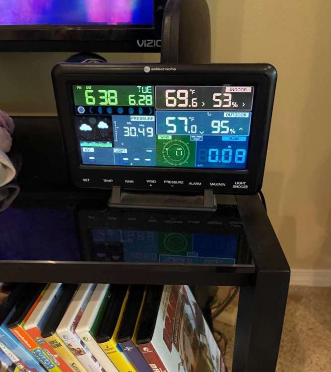
06/28/2022 As can happen with dry air and dry conditions ,Yesterday was a very cool day for late June. The official H/L was 73/52. The high of 73 was the 6th coolest for the date and the low of 52 was the 8th coolest for the date. The official overnight low at Grand Rapids looks to have been 48 and for June 28th that ties for the 2nd coolest low for today. That ties 1923 and 1930 for the 2nd coolest low the record low of 43 was set in 1992. For today the average H/L is 82/61 the record high of 97 was set in 1931 and 2012 and that record low of 43 was set in 1992.4 points
-
It's not trending warmer, it's just more mixed than its previous run. The airmass is objectively colder. There could be a stratoform rainband with thicknesses above 564dm and it could still be a -11F kind of day. Kind of like how weak ridging with strong onshore flow will bring 55F drizzle, while a potent trough with sunny skies will bring 65F spotty showers. Difference is, the latter is more likely to produce a cooler outcome than the former. Waffling between mixed and non-mixed thermal profiles is the hallmark of long range variability. It might tend towards a mixed outcome with time, but the real, current trend is clear: the 4th is looking more unsettled than not.4 points
-
GEM gives Spokane two kinds of fireworks on the 4th3 points
-
Ended the day with beautiful sunshine and a high of 71. About perfect.3 points
-
KSEA actually spiked to 65F, meaning there is no record set. Still ties 6/13-6/14, 2002, when the high temperature dropped 26F from 94°F to 68°F as the all time June record.3 points
-
Wow this took off quickly. Full blown thunder, lightning, heavy rain and pea sized hail now. Bigtime surprise this evening.3 points
-
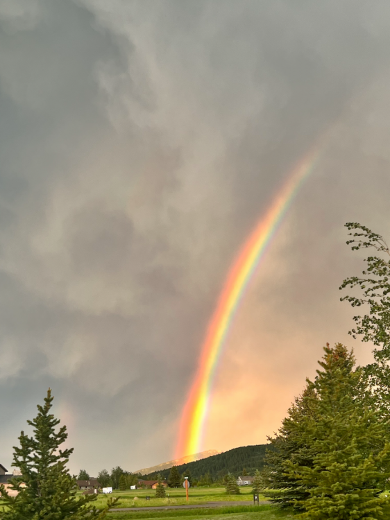
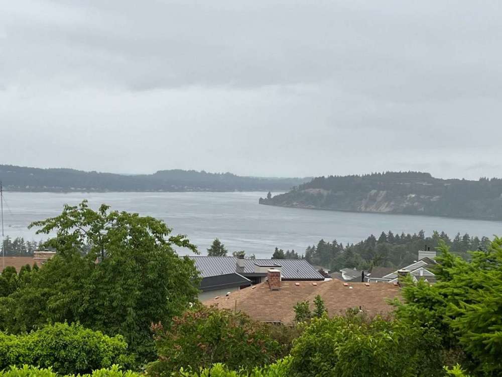
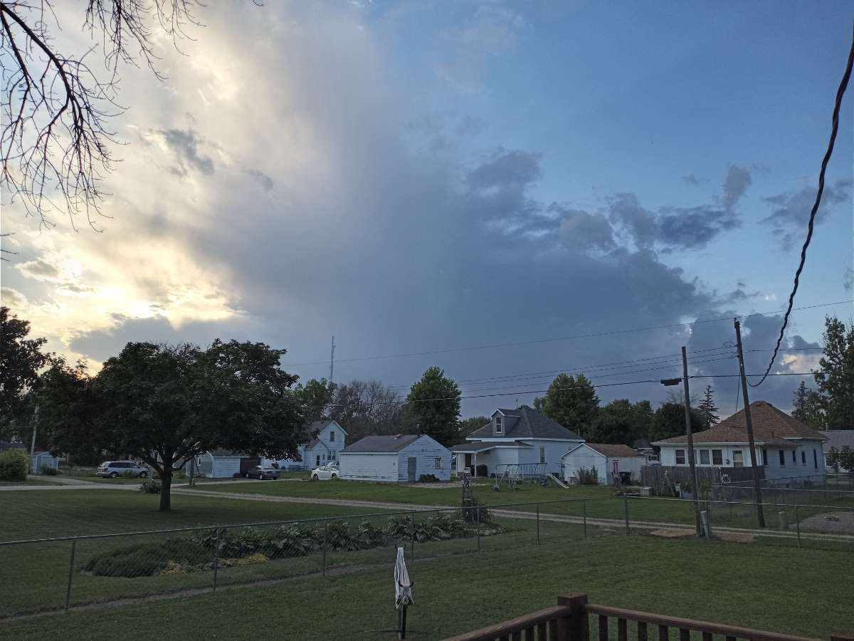
Another top notch evening out on the deck. Did some yardwork and now grilling up some late dinner on the Weber. Took this pic from the deck. Looks like an isolated storm might be moving in.
 3 points
 -
Welcome to my world.3 points
-
Apparently there was a NOAA COOP station really close to my current location from 1967-1969. Some stats for the winters of 1967/68 and 1968/1969: 1967/68: 11.6" of snow Dec: 4.6" of snow, Coldest day: 33/15 Jan: 7.0" of snow Coldest days: 33/23 and 30/24 1968/1969: 39" of snow Dec: 18.7" of snow Coldest day: 15/7, "blizzard conditions in area" (Wind NE 30 MPH, not sure if that's gusts or sustained), next day 30/8 "sleet till noon and ice 1/4" thick" Jan: 19.8" 1/1: thawing, high of 35, but apparently only a high of 27 in E PDX 1/2: "roads clear after worst snow since 1950" 1/6: "snow almost gone" 1/24 (NE 35MPH, not sure if gusts or sustained) & 25: 26/17 1/28: 30/16 Feb: 0.5" of snow3 points
-
From seat coolers to seat heaters in less than 24hrs!3 points
-
18z GFS looks like an Andrew-Approved summer pattern.3 points
-
...What I am referencing in my previous post.3 points
-
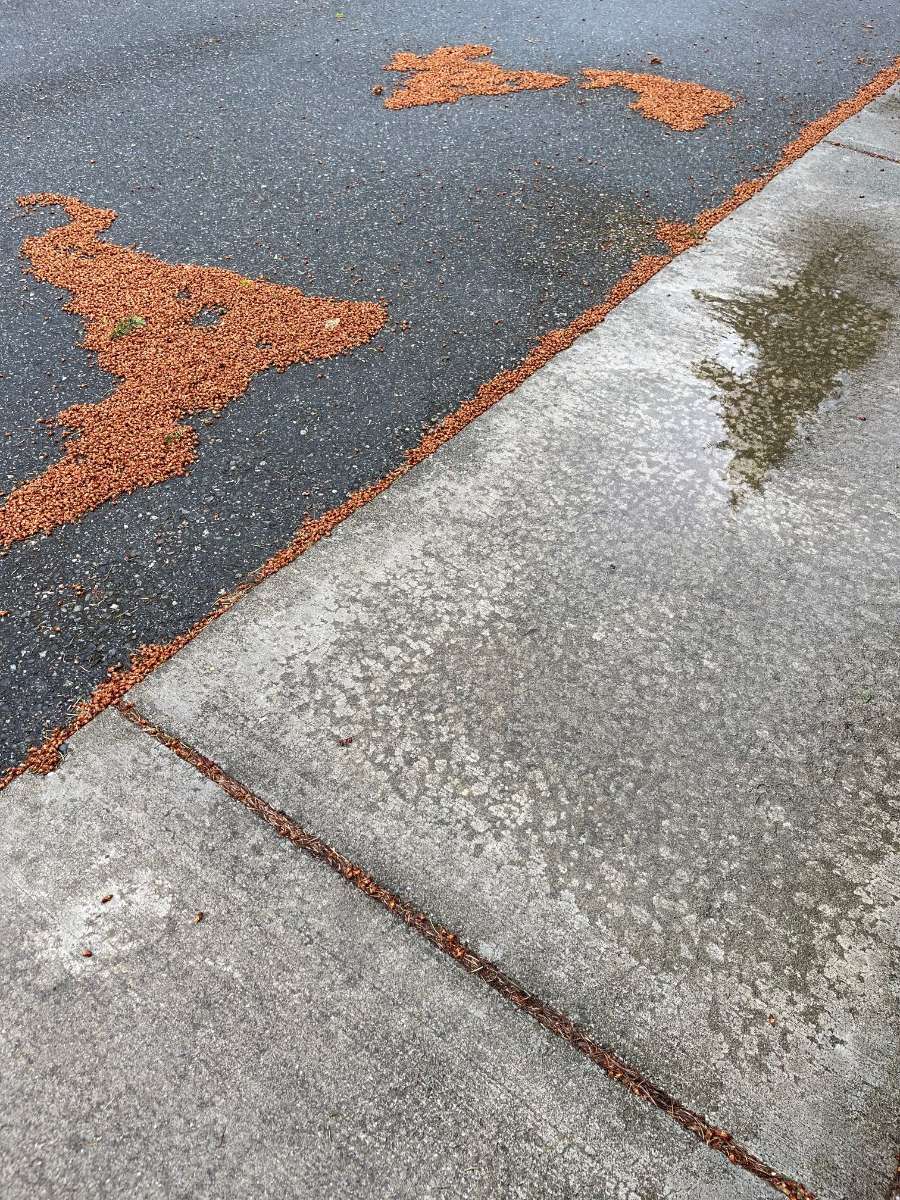
Those are discarded staminate (aka male, pollen-bearing) Douglas fir cones. That’s why there’s been visible pollen on things: Doug firs really pump it out. There’s a Doug fir in the backyard of the house just to my north, and I noticed my bike was covered with specks of yellow dust this morning.3 points
-
Happy Fall everyone!
 3 points
 -
Looks like YVR will have a midnight high for the day. Quite unusual for late June.3 points
-
I’m really not sure if it’s worth even responding to you since you are kind of like that annoying fly on the wall who says things that don’t make sense…but Seattle and near the Puget sound was the exception of the PNW last summer. Many stations across the PNW were record hot just last summer. Not to mention years like 2015,2017 2018 too. If anything we were due for a normal or cooler than average summer.3 points
-
Starting to rain.3 points
-
12z EPS isn’t terrible. Some signs of a warm up in the long range but there is a lot of spread out that far.
 3 points
 -
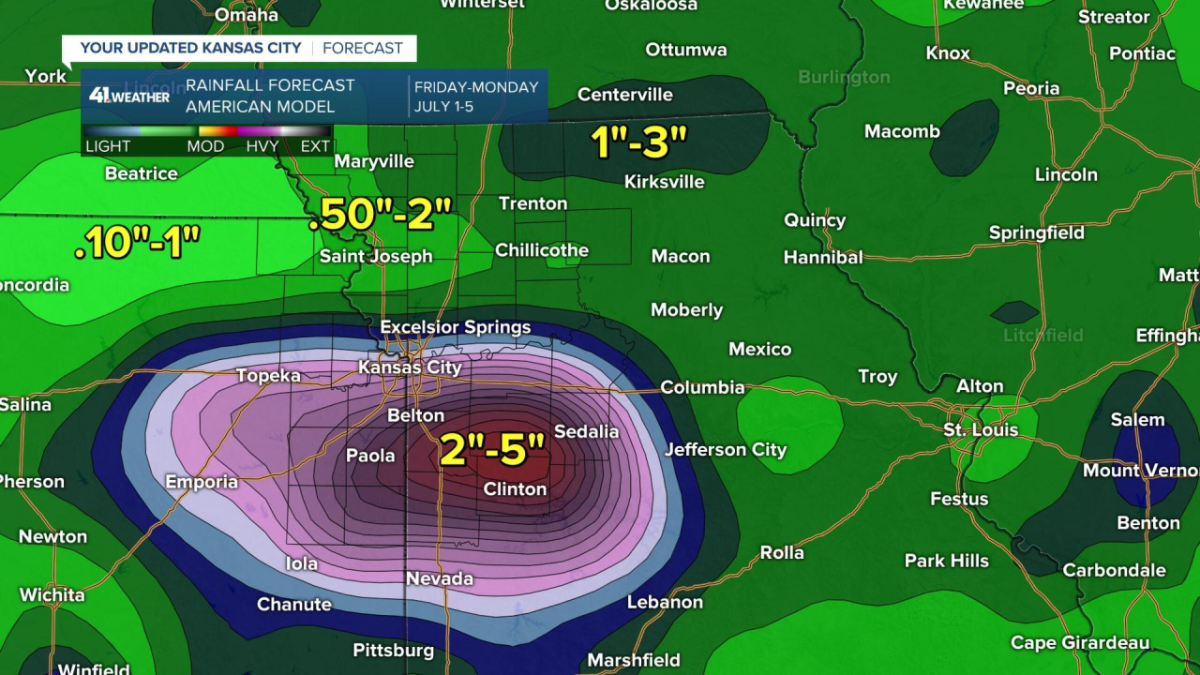
12z GFS is nice as it targets western MO and Eastern Kansas with the heaviest totals Friday and Saturday. Crazy how a few miles makes such a big difference on the 30 day totals. 20 miles both north, south and east of me have had above average precip over the last 30 days.

 3 points
 -
We're barely making it to the mid-60s prior to the 1pm update. This is a -20 difference at BFI from yesterday.3 points
-
Looks like Silver Creek Falls' lowest July maximum was 53 in 1988. Their coldest low is 32 in 1970. For SEA, their lowest July maximum is 54 in 1966, with a monthly low of 43 in 1949.3 points
-
A high of 57 in Seattle on the 4th... with rain and clouds of course. Very nice.
 3 points
 -
My wife had a daughter when we married, then we had 2 kids together. We talked about a third (giving us 4 total) but decided 3 was enough. All in all, it was the right decision, but there have been a couple of times I have wondered.... That said, my youngest graduated when my wife and I were 46, so there is that. My daughter has continued to live at home, but she has been a little slow to get the whole adulting thing figured out. She has epilepsy so she does not drive. That makes living on your own (or with a roommate) a little more tricky. She is graduating next month with a BS in Business, and seems to finally be motivated to leave the nest. A good friend of mine has 8 kids, and he said it started to get a little easier after the 4th because the first ones are getting old enough to help out with the younger ones. He is actually the one I mentioned yesterday that has the Pyrenees mix and all the farm critters. He is raising a lot of his own food (especially meat/eggs) to offset the expense of 8 mouths to feed....well 7 now, the oldest turned 18 and left the nest last year. So, @SilverFallsAndrew if you you aren't stopping at 5, it should be starting to get easier.3 points
-
3 points
-
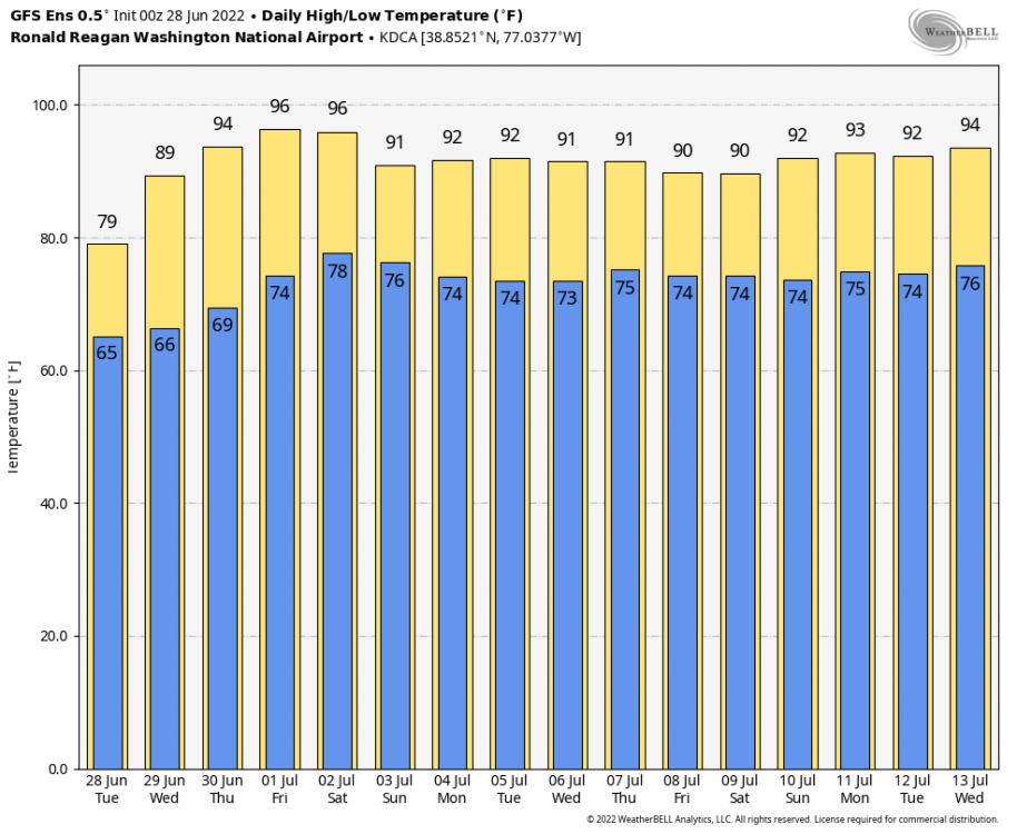
This mornings GFS looks great over the next week. Really hope this verifies, it would be the icing on the cake to go along with these great temps we're having. The Euro on the other hand

 3 points
 -
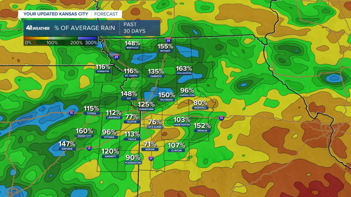
Yikes! I didn't realize it had been so dry down your way Clinton. Hopefully Mother Nature will soon fix that.3 points
-
Yeah, it always takes me time to mentally adjust when I come on this forum. In real life, when people say the forecast looks “great” they always mean warm (but not too hot) and sunny. On this forum, over half the posters mean cold and wet by “great” or when they say the models have “favorable trends.” I think we need a preference cheat sheet so noobs can interpret.3 points
-
It was rather chilly up in the Northwoods yesterday...
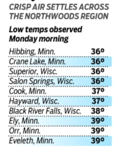 3 points
 -
As the saying goes, "The Tide Turns"....once we get past the drier pattern around the MW/GL's this 4th of July weekend, I'm seeing a great signal for a NW Flow pattern and a more active one. Nice wet signal showing up on all the models. 0z EPS... On a side note, this is the time of year we begin to loose the amount of daylight we can enjoy in the evenings. In fact, yesterday was the latest sunset of the year for our area. The sun set at 8:31:29 local time and today it will set at 8:31:28 and continue the slow side towards Autumn.
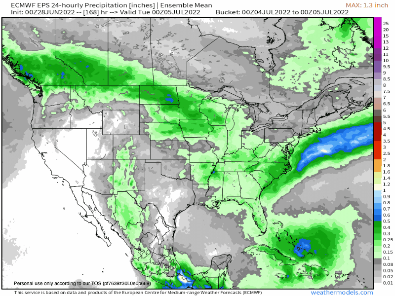 3 points
 -
We’re about to succumb to the summer soup.
 3 points
 -
Raining.2 points
-
It's the mid 30's to 50's part that sucks. Around 3 or 4pm we will reach the 60's for an hour or two on 4th of July. Gonna be lot's of Bay Area folks wearing North Face Parkas. Lol2 points


This leaderboard is set to Vancouver/GMT-07:00