
Leaderboard


Popular Content
Showing content with the highest reputation on 02/01/23 in all areas
-
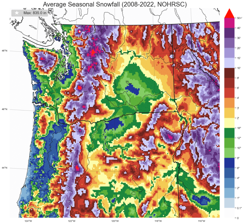
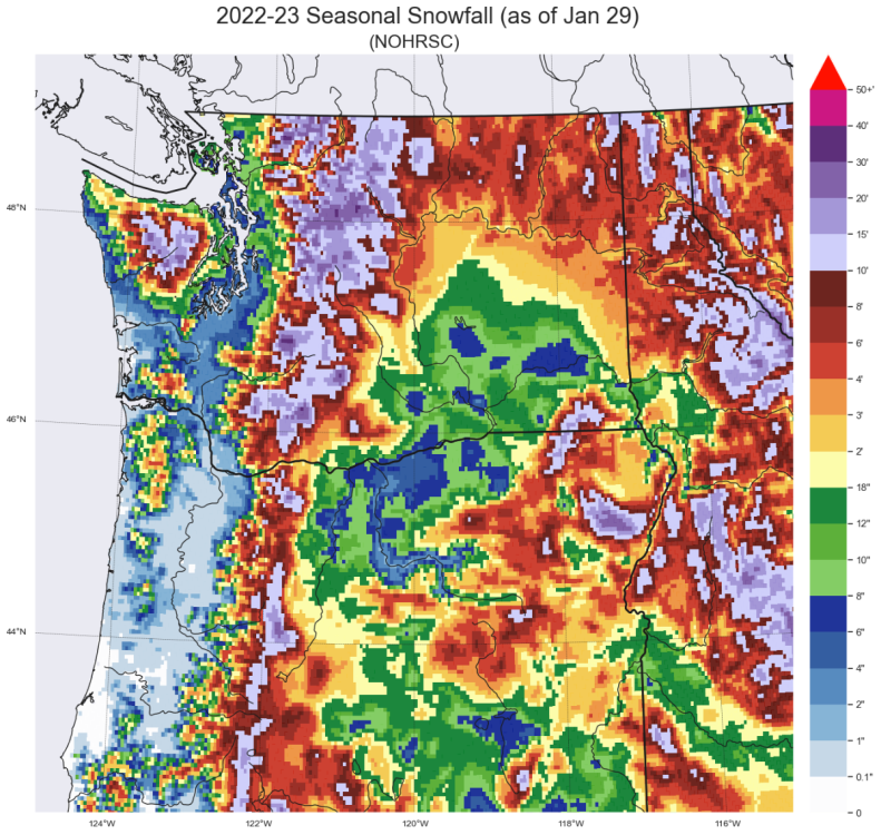
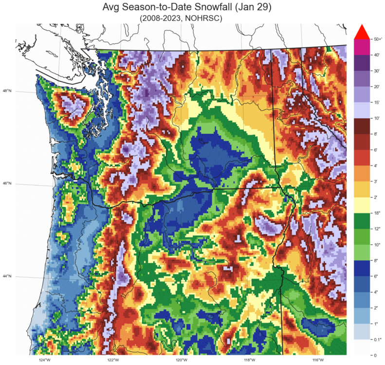
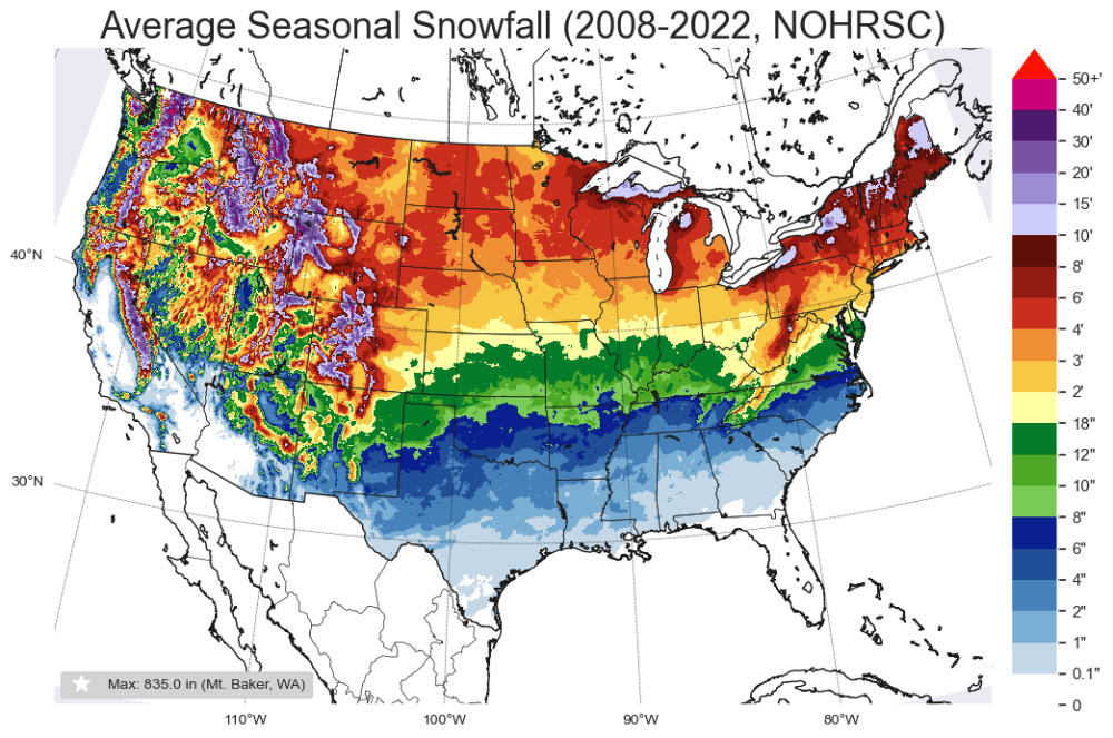
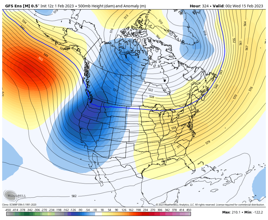
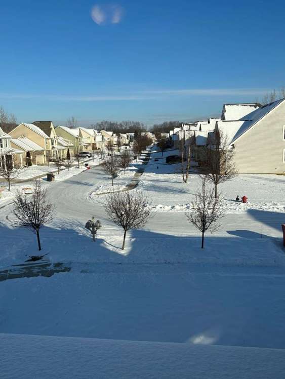
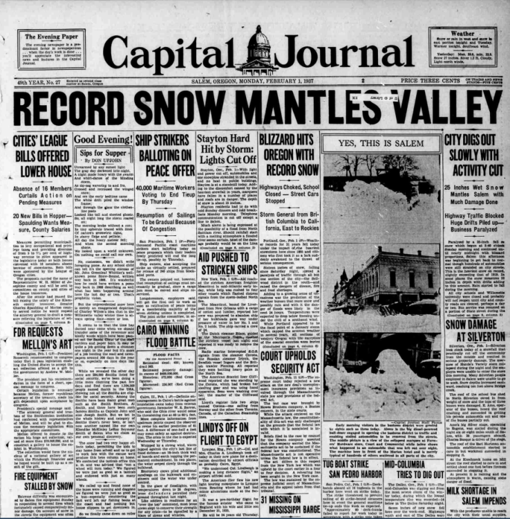
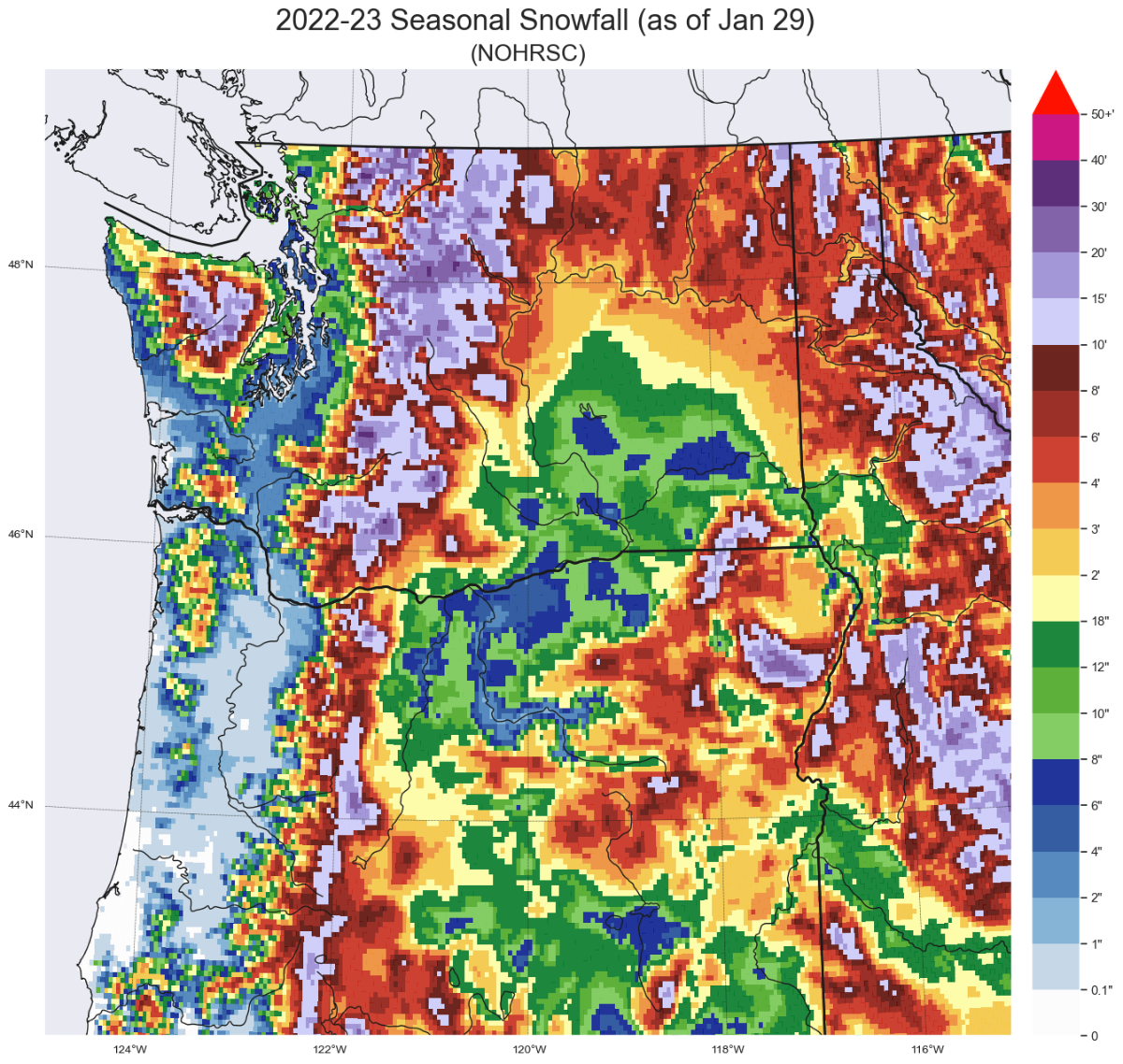
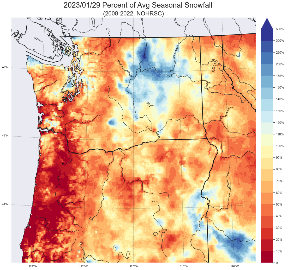
The lack of snowfall, especially on the East Coast, inspired a discussion earlier this week about whether or not parts of the country have had a "good" winter. I was intrigued to see if I could visually represent how much snow had fallen, especially compared to average. NOAA through the National Operational Hydrologic Remote Sensing Center (NOHRSC) has a product available for the last few years that estimates the amount of snow that falls each season. National Map Interactive (zoomable) Map I'm not exactly sure everything that goes into the algorithm, but it sounds like it uses a combination of official station snowfall records, CoCoRahs observations, radar estimates, and an algorithm that accounts for terrain and historic precipitation. I imagine the estimates aren't perfect, but in my experience that actually do a pretty good job at snowfall estimations in Western WA. I believe the resolution of the data is around 3km, but it may be slightly higher than that. I don't love the color bounds presented by the official data, so one of the first things I did was make the bins finer so that we could see snowfall differences between 6" and 12" and changed the color scheme slightly. Here's the map of the snowfall up to Jan 29th for the PNW: You can see how much of Washington north of Everett has picked up above 8" of snow this winter while PDX to SEA has seen 1-4" and there's not much south of PDX. NOHRSC has data for every winter from 2008-09 to 2022-23. Obviously that's not completely representative of historical climate norms, but 15 years should be relatively representative of the current climate state. I took the data from all 15 years and averaged it together to get both an average seasonal snowfall (how much snow usually falls during the water year (Oct 1-Sept 30) and how much snow falls usually during the season to date (Jan 29 was when I first got my data). Here is the average season to date snowfall for the PNW (so 9/30-01/29): And here is the average seasonal snowfall (total) for the PNW: For the entire season the Seattle area averages 6-8", BLI averages 8-12", PDX averages 4-6". I also highlighted the max average value (both in this image and nationally) which to no-one's surprise is Mount Baker with 835" of annual snowfall (look for the star). There might be specific locations that receive greater snowfall, but they were not detected with this resolution of data. And here's the national average seasonal snowfall:
 11 points
 -
I may have posted this yesterday, but the eastern side of Steens Mountain is incredible, this was from at least 30-40 miles away. It is just absolutely massive. The view of the mountain from the north is not as breathtaking in the summer, but from Crane yesterday, due to the stark relief caused by the snow cover it was jaw dropping, an absolutely massive mountain.10 points
-
As I watched it I couldn’t help hearing in my head the bus driver repeating “sorry” over and over in a heavy Canadian accent.10 points
-
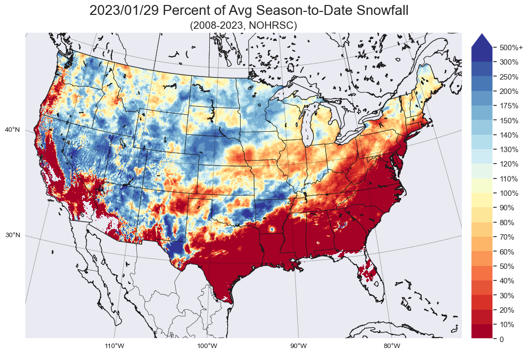
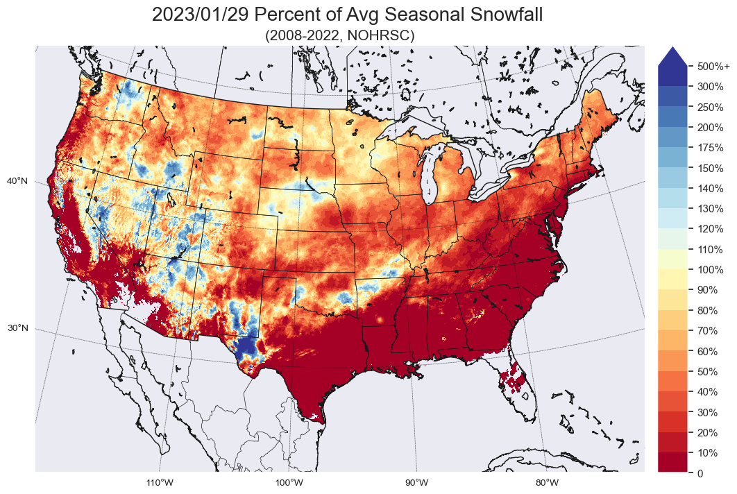
Part 3/3 And finally here's the national picture. This is what percent of the snow that's fallen we'd expect to see by January 29 during any given year. Much of the western mountains (with the exception of the Cascades) are above average as is MN, NE, ND, and the area stretching from western TX to southwestern MO. That area doesn't see much snow to begin with so the 500% of average in TX is because a place that averages less than an inch a year got like 4" when it got cold in Dec. And here's the percent of seasonal snowfall that has fallen so far. There's a lot more red on this map, but this map only verifies if it doesn't snow a flake for the rest of the season. There are a couple places (parts of the Sierra, Okanogan Plateau, eastern Utah, etc) that have seen more snow than they'd expect to see in an entire winter, but most areas still need more snow to get up to the winter average.

 10 points
 -
When the worthless model shows something promising
 8 points
 -
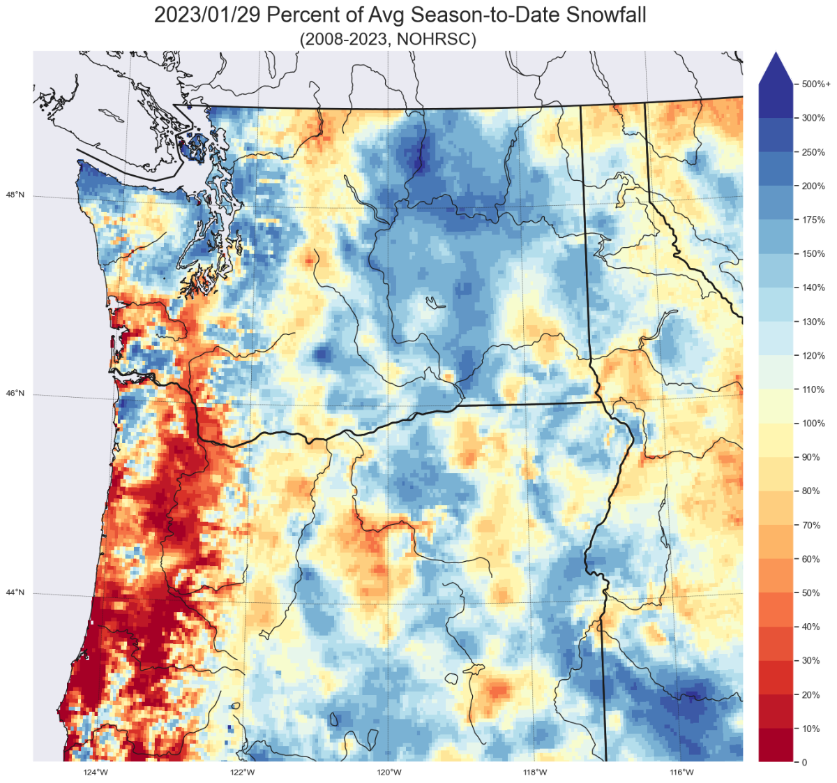
Part 2/3 That's the specific values of snowfall, but I wanted to see how this season compared. I took the season to date snowfall (for winter 2022-23) and divided it by the average season to date snowfall (average for 2008-2023 through January 29). Here's the PNW: You can see most of the Western Washington foothills are doing pretty well as well as the area north of SEA, while the spine of the Cascades and the lowlands south of Olympia are doing quite poorly. You can compare this to the percentage of the average entire season snowfall that has fallen where we can see that a few places (such as up near the WA/BC border, the Okanogan Plateau, the Everett area, and the Kitsap peninsula have seen more snow this season than they would normally see for the entire winter, but every other place is significantly below average (especially for Oregon).

 8 points
 -
The Feb. 1st storm for the central Plains ended up staying well south into Texas. Remember, this storm stranded truckers in the Dakotas for days on end...this go around, sunny skies there... Here in KC, 50 days ago in cycle two, KC received 1-1.5 inches of rain in the city, very wet storm. Here in cycle 3, we received ZERO! This is quite disappointing as this was one of our signature storms per the LRC for KC and we have cold air in place curenttly. Did the LRC fail us, IMO, yes and no. The storm is still there, right on time, but, in a much further south spot. Can this be predicted, I don't know. For me, I was expecting a huge storm here in KC FEB 1st., give or take a few days. Dec. 15th to Dec. 27th was the coldest stretch of winter weather here in KC. 12/13 days were below average and this time frame is due back in Feb. 3rd, this Friday. However, we are forecasted to have much above average temps starting this weekend through what appears to be all next week. The total opposite of the Dec. 15th-27th period. Following that, KC, starting on Dec. 28th, had 28+ straight days of above average temps and mainly rain storms in Jan. Storms? Cycle two: Dec. 19th we had a small accumulating snow here in KC with more off to the NE of here. Dec. 22nd, artic air poured in and KC received 1-2 inches of snow with more off to the east and northeast. Remember, this storm did not DIG!! it was way to progressive.. Dec. 25th, clipper system produced little in KC but did produce accumulating snow in the northern plains through Iowa and off to the east of KC. Jan. 2nd, another big rain storm in KC, snow off to the NW. So, Feb. 7th should see a smaller storm in the Plains, followed by a bigger storm 2-4 days after that and a big storm around Feb, 21st to match the Jan. 2nd storm. The 6z GFS at face value, shows all of the above in the extended.....BUT, it seems to warm of a pattern to be a good snowy stretch for most on here. It does get colder towards the famous "10 days away saying" on this run. Let's hope the data trends colder as I believe we do have a great chance of a stormy FEB in the Plains according to the LRC. Again, here in KC, between Feb. 10th and March 10th last winter, we had (4) good winter events. I'll take that again!!! It is still winter, you can still have hope now, you can't have hope in July as there is no chance of snow.8 points
-
I'd be busy fishing! I think.... Unless that's a sewage treatment pond. I heard they have some big 'brown' trout. Yeah bad Dad joke. Real bad! 00z GFS in 2 hours 39 minutes7 points
-
And that could be our gangbusters window for a little wet AM snow on the hilltops! Should be pretty fun for all.7 points
-
Today’s spring fever talk is both very encouraging (for snow lovers) and very aggravating (for sensitive members).7 points
-
The Sheephead Mountains are NE of Steens Mountain, when viewed from the top of Steens they are just a low drab set of hills in the vast desert to the east, but they were pretty cool with the snow cover. Going through the pass there was probably about 2-3' of snow on the ground. The range is so dry it doesn't even support trees. This conservationist has identified the potential for a very large designated wilderness area in the range. https://www.andykerr.net/odg-sheepshead-mountains6 points
-
Is it just me or was the 00z a huge step in the right direct, but no one cares anymore?6 points
-
This would be some crisp weather.6 points
-
I remember specifically being in the Centralia Burgerville drive thru when it was snowing during that backside “event.” 2006’s retraction/retrogression was definitely more durable. More of a double shot with the initial shortwave on the 14th being quite similar to what we had over the weekend at the 500mb level. Then of course the big backdoor penetration on the 17th.6 points
-
12z CMCE still ripe with potential
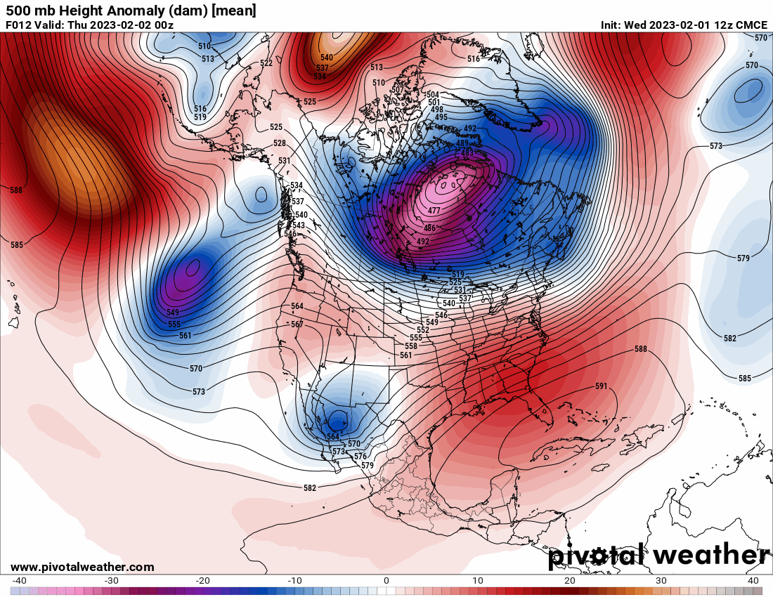 6 points
 -
6 points
-
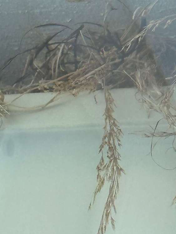
Suns out, snow on the ground and we have a brave bird making a nest between the gutters. Temp is 18.
 6 points
 -
It was a rather nippy walk this morning (11F) but I enjoyed the cold air as it makes you feel alive. The bright sunshine reflecting off the snow pack and producing a twinkle is the quintessential reason why I enjoy these winter mornings.
 6 points
 -
After tonight I’ve never felt stronger about the fact we all need to meet up!5 points
-
For claiming to be such a renegade badass you sure seem to have mighty thin skin.5 points
-
Oh boy... more April snow for us.5 points
-
We went from tracking when the first decent rains would fall to snow chances in less than 2 weeks this year.5 points
-
2019 was one of my favorite weather years in general. There was some dynamic stuff at times in 2021 and 2022…but 2019 had some amazing cold, snow, thunderstorms and a summer where it actually rained at times!5 points
-
Agreed. That was an amazing warm season overall, with a ton of convection but almost no fires thanks to the lack of high end heat and long dry spells Then we went straight into chilly weather by late September. 2019 was one of the coolest and more dynamic years overall of the last couple decades. I think it had the coolest annual average for PDX since 2011 (which was their coldest year since 1985). Featured two top tier cold months which is a very rare feat these days (February and October).5 points
-
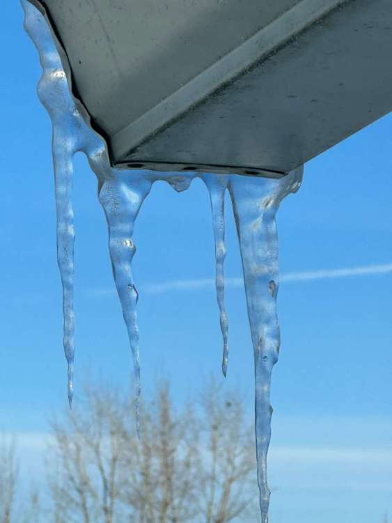
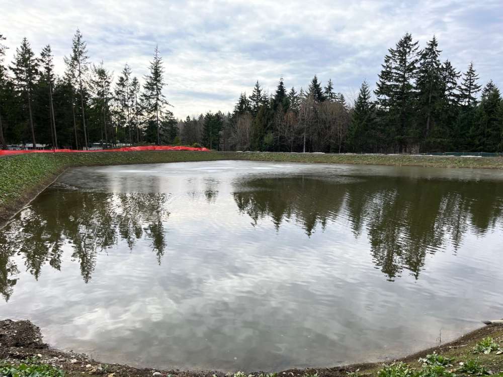
Still some ice in the pond here in federal way!
 5 points
 -
Canadian ensembles Alert5 points
-
The best valley snow event I’ve experienced was 02/14 and DEC 2008. Jan 17 I saw a grand total of 3-4 inches. When i moved to Ridgefield. Feb 2021 was awesome. April 22 was also undeniably a fascinating event. I tend to toss out years like Dec 2008 and February 2021 because Clark county just isn’t considered “valley” call it a character flaw. Of all snow events. February 21 and April of 22 will always stand out to me. Excluding my pre teenage years living in Lynnwood.4 points
-
January 1949 at the Harney Branch station was absolutely bonkers. Warmest max for the month was 33, warmest low was 14. But the cold in January 1937 was next level too. 1949 https://climate.usu.edu/mapServer/reports/e15daily.php?stn=USC00353659&year=1949&month=1&unit=EN&network=direct:ghcn&sidebar=0 1937 https://climate.usu.edu/mapServer/reports/e15daily.php?stn=USC00353659&year=1937&month=1&unit=EN&network=direct:ghcn&sidebar=0 They also scored a -2/-45 in January 1930, but the -11/-45 day in December 1924 takes the cake.4 points
-
Don't hate the 00z GFS. February 2020 VIBES.4 points
-
FWIW it appears the 00z GFS drops a pretty chilly trough on us the middle of next week. A nice 49/23 day at SLE. Back down to freezing already. SLE put up a +0.2F departure for January. Last year was 0.1, so warmer than last year. Though they managed to keep their average high below 50, 48.9 to be exact.4 points
-
At this point it's a near certainty that literally every comment made on here is some variation of 3000 other comments made before it. Many of us are soon to be pushing 18 years posting together. We're almost legal!!4 points
-
On this day 86 years ago Salem had a 41/23 day with 25" of snow.
 4 points
 -
March madness babay!!
 4 points
 -
Wednesday evening update! At this point at the coast, we were seeing strong westerly winds with dew points in the teens. Unheard of. I also had absolutely no plans at this time of attending law school…
 4 points
 -
That block over the Beaufort Sea/Western Arctic plays a crucial role insofar as continental cold is concerned.4 points
-
More cold air in BC on this run... that is definitely an improvement.4 points
-
I dunno...GFS with something around the 9th...Euro says dry through the 11th....Sun issues start around the 15th of Feb...winter ain't over, but sure isn't a harsh one. Going to be an early ice out...still only around 12-16" of ice on a lot of lakes...Should be 20"+ everywhere by now4 points
-
True winter days here in S MI w/ a nice snowcover otg and very cold temps. Hopefully some more snowstorms down the road, although, not looking too promising this week. Still, plenty of ol' man winter left.4 points
-
Haven't had this look all winter long, we have just not had the cold in place at the right time. I may not have this look this winter....at all. Man, that would be super depressing. Still holding out hope as we still have 7-8 weeks of winter. NEVER GIVE UP!! Glad you were able to score a nice winter stretch!!4 points
-
I don’t get some people saying this is the most boring winter ever (western WA folks) Do you guys even remember 2012-2013 or 2015-2016? Even 2019-2020 was worse than this one…maybe a little better in PDX with the mid March event.4 points
-
Crazy the difference a year makes! For us, it's been two years but you have to figure sooner or later we will get back to a snowy winter.......4 points
-
Shooting the breeze with Lezak back in early Dec. he mentioned La Nina could fade late winter and we just might have a great finish if that did indeed happens. I so remember him saying that. Come on snow, don't finish around 4-5 inches in KC and surrounding areas, do what you did last winter, finish strong!! I think I ended up with average snowfall with only around 5 inches total come Feb. 1st 20224 points
-
You mean while you're out of town?4 points
-
Always nice when the forecast low busts cold. Supposed to be 34F but we are 31F and another beautiful, crispy night under the moon and stars. Grateful for so many cold nights. Feels like winter.4 points
-
All three ensemble means take the PNA below -2 by mid month. Something is brewing!4 points
-
All three ensemble means takes the PNA below -2 by mid month.4 points
-
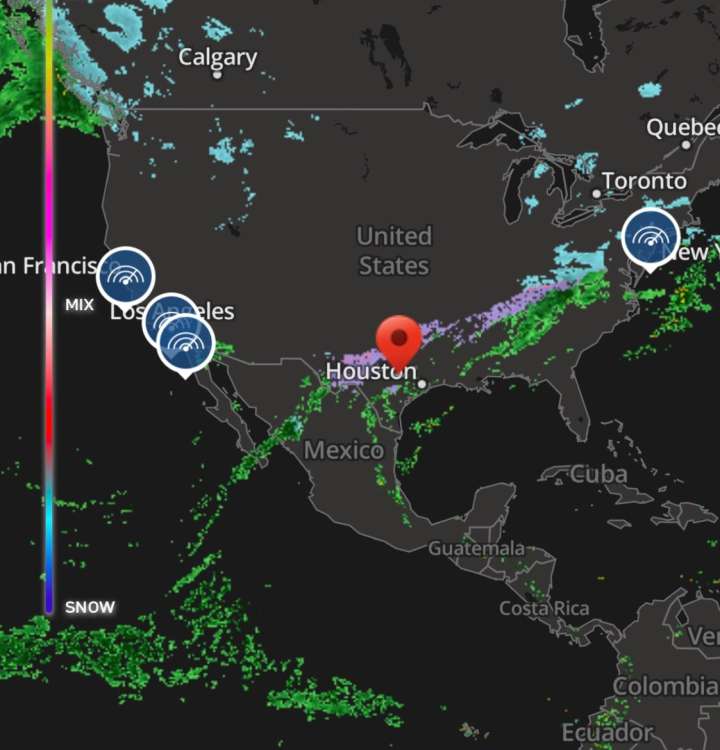
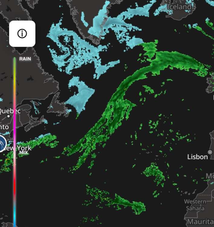
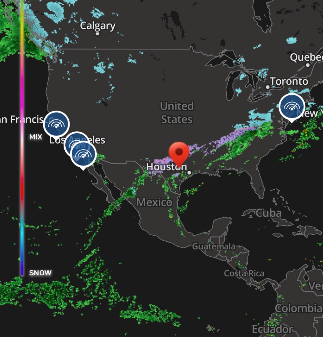
I was curious as to where this event was coming from and the global radar answered my question. All this moisture is being energized from out in the Pacific far west of Mexico. The line stretches to NE where it’s delivering snow. I have a friend near Boston that hunkered down. This is one long string of “pearls.” It leaves New England, picks up Arctic energy and swoops over to Britain. Amazing
 4 points
 -
This needs to go viral. We need 2-2 to be Slug Day in the Northwest.3 points


.png.88c67929bc1c27943d3ae1fb05443505.png)


This leaderboard is set to Vancouver/GMT-07:00