
Leaderboard


Popular Content
Showing content with the highest reputation on 04/23/24 in all areas
-
I think their 2" on August 24th 1992 is absoluetly f****** absurd. At least in June there is just enough residual wintertime cold left over at the poles to drop snow levels down to 5k feet should it be displaced south, and enough of a poleward thermal gradient still in tact to spawn strong-ish cutoff lows around the meridian line. Mid-late August is a joke of a time to get a snowstorm, even at their somewhat high elevation. They pretty much combined the strongest weather system possible at that time of year with the coldest air possible... Neither factors being very impressive nonetheless. But enough is enough. The only month I doubt they could pull off a snowstorm at all would be during July, and even then I bet the first week holds some out-there potential in the right setup. July 15-August 15 is off the table though. I think....5 points
-
One record I think is absolutely insane is the 14.3” of snow Bozeman got on June 13, 2001. The fact that happened during meteorological summer is crazy. Though it was recorded on the MSU campus weather station and not at the airport.5 points
-
Snow at home is just fundamentally different. Never hits the same when you're on vacation.5 points
-
Models continue to bless the west.5 points
-
Nice morning outside.5 points
-
2016-17 was another good water year for CA which happened during a multi year nina phase. Which of course you deny.4 points
-
00z GFS gives me a foot of snow, ITTTTTSSSS COMIIIINGGG!! (I refuse to look at the kuchera map)
.thumb.png.db394dec03f2da22c396f13216d7e450.png) 4 points
4 points -
We drove to the Royals Orioles game on Sunday (go O's!). And there was quite few dry areas between here and kc.. much wetter here thankfully. But looks like we all get in on it soon!4 points
-
Gorgeous evening. My daughter got the Irish setter up on her trampoline and is hosing her down. Pandemonium.3 points
-
Overall this has been a nice spring.3 points
-
I went to the Columbia River Gorge today are there’s still some drifts on the Oregon side that’s sheltered away from the . It’s probably from the January storm and it’s crazy it hasn’t melted yet in 3 months.3 points
-
May 2010 was frigid for the western half of the country.
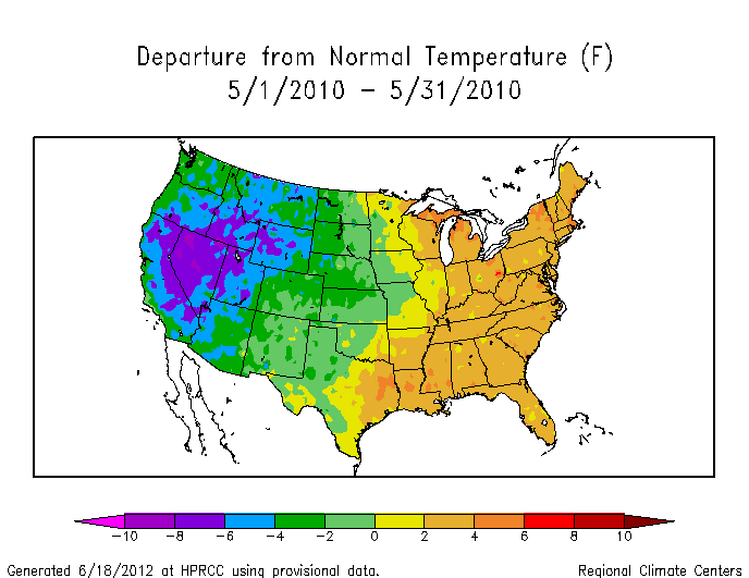 3 points
 -
The impressive speed of this CCKW across the Pacific is another indicator the niño is losing its grip on higher frequency elements of tropical forcing.
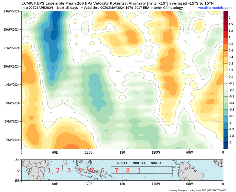 3 points
 -
Pretty impressive storm for almost May.
 3 points
 -
I feel like the west is entering a pretty special era.3 points
-
This is probably going to be a memorable outbreak for some. Everything is coming together for some big days. SPC just updated their day 3 outlook to add an enhanced. I suspect we get a moderate or two during this stretch.3 points
-
Oh. Well hopefully that Nino-Costco magic strikes again with the strong Nina event this coming winter. Would hate to see something nasty like a Nino-Big Lots signature emerge.3 points
-
Not really. It was never anything more than a very weak Nina to begin with, and the weather patterns remained remarkably consistent across the CONUS pretty much throughout so there was no discernible impact from any of the marginal SSTA warming in the equatorial Pacific. It will go down as a weak Nina cold season that for one reason or another had an unusually dominant grip on the weather patterns. Kind of the inverse of a year like 2004-05, which was only ever a very weak Nino but one which developed a solid death grip on the weather patterns nevertheless. It's cute that you're still so hung up on it, though.3 points
-
I always get the in-flight WiFi too. Can only play sudoku and minesweeper for so long3 points
-
It’s healthier to talk about your feelings as opposed to bottling them up. Try it sometime.3 points
-
Nov/Dec maintained the weak niña base state, but that regime imploded in January. It was quite remarkable, actually. By February, the niño-costero signal was stronger than the preceding niña ever was. Then it abruptly collapsed in May/June, and a more substantial EPAC niña signal emerged during summer 2017 (though it was still disconnected from the PMM/IPWP state..the entire system state appeared disheveled and confused in the years following the 2015/16 super niño). I figured you guys would have some intellectual curiosity on that front, but apparently people would rather cling to preconceived notions because of how the weather behaved in their backyards. Sad.3 points
-
12z runs look great!!!!!!!!!!!!!3 points
-
Tropical forcing was already El Niño like by spring 2023, despite the lack of an official declaration. January 2023 was an intraseasonal event but was also a harbinger of things to come. Couldn’t know this in real time, but the ocean/atmosphere system had already made up its mind about where it was going at that point.3 points
-
Have a safe trip man!3 points
-
PHX torched yesterday and it sure did feel HOT...it hit 102F at 2:04pm...I was at the pool earlier in the day around Noon and it felt like a day in late May or early June. some ppl were complaining but I embraced it and didn't mind the Heat at all. Looking forward to the cool down coming later this week into the weekend.3 points
-
Had a low of 33 here this morning. So close to a freeze.3 points
-
This is the part of the pattern that can put a dent in the ongoing drought and will likely produce alot of damaging storms. Here's some thought from Gary Lezak as this is by far the most exciting stretch of weather in this years pattern and he thinks 3-5 inches of rain over the next 10 day is certainly possible for the KC area. Weather 2020 Well, here we are almost 45-days after the strongest and most deadly severe weather outbreak in this year's LRC, March 12-14, and around 135 days after the other big winter outbreak in this part of the LRC, December 9th. Gary Lezak @glezak Do you remember this day in the previous cycle? 3 people were killed in western Ohio. This part of the pattern is cycling back through, one of our signature long-range predictions, in the next six days! If you know the LRC, then you know it is due around 4/283 points
-
2 points
-
I get the point, but I can still tease you - especially when you use that approach most when it fits your preferences/arguments.2 points
-
Wow2 points
-
You feel a lot of things.2 points
-
None of us control anything, Tim. Why should you or anyone care about anything.2 points
-
Oregon needs all the snow they can get. So happy for the basin areas.2 points
-
The 2023/24 niño emerged from a niño-costero event. First time we’ve seen that type of evolution before the 1976 Pacific Climate Shift. This is fascinating stuff when you really dig into it.2 points
-
This is an informative read: https://link.springer.com/article/10.1007/s13753-017-0151-82 points
-
What sounds better, seeing 12" of snow on vacation and then 4" at home a few days after you come back, or see 12" on vacation while 4" falls at home, and then when you come back it's back to boring weather?2 points
-
Colorado-like diurnal cycle today. 35°F at 7AM to 71°F by noon. Will miss this come July when it feels nastier at 9PM than it did at noon.2 points
-
We get free wifi through T-Mobile on Alaska. Seattle based companies partnering up.2 points
-
I digress, as evidenced by my non-response. We all have our own unique oddities. Sometimes those oddities are weird weather preferences, sometimes it’s other stuff. No amount of debate on a weather forum will change that.2 points
-
But you do that literally every day!2 points
-
There was no El Nino in spring 2023 and it was one of our coolest and cloudiest springs on record. It's extremely rare to have the jacarandas not bloom until late June or early July here, but that's what happened last year.2 points
-
Like Phishy says, let’s check back in in a couple weeks.2 points
-
Not if the California cold and wet, PNW warm and dry curse that began in 2023 continues.2 points
-
first it has to happen2 points
-
Don't like leaving on such a gorgeous day... but don't mind missing the next week after today.
 2 points
 -
Here is the latest CSU ML severe forecast for the next 6 days.
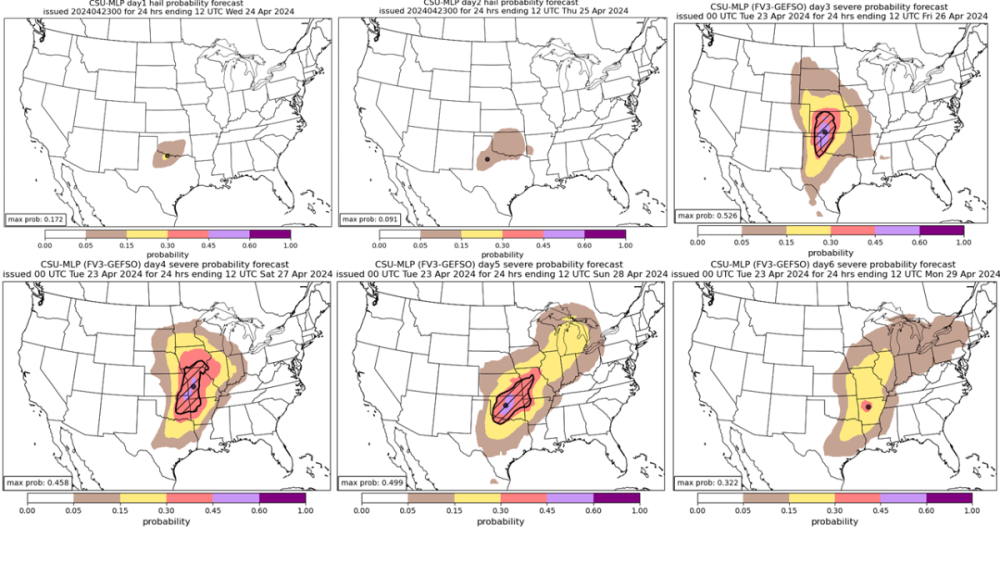 2 points
 -
Putin destabilizes another nation. …Gobble Gobble https://www.newsweek.com/russia-moldova-putin-shor-sandu-18928022 points
-
How deep into the year can you see snow? Seattle proper has arguably seen flurries as deep into the Spring as May 1st (at night w/o accumulation and probably a precip mix of course), so I imagine May is no issue up there.2 points
-
49F and clear. Nice night.2 points
-
Your climate seems like it would be heaven for Jim.2 points


.png.adef18d54aee895f2fa17d13a1f5298a.png)


This leaderboard is set to Vancouver/GMT-07:00