
Leaderboard


Popular Content
Showing content with the highest reputation on 04/19/24 in Posts
-
GFS shows one of the most impressive daytime temp crashes I've ever seen tomorrow. From 71 at 2pm to 49 at 5pm in Tacoma.
 7 points
 -
It delays the rain a couple hours behind the GFS. Still drops to 48 by 8pm, so still an impressive crash.6 points
-
Hello Friday... going to be a spectacular day.
 6 points
 -
Pretty enjoyable pattern overall. Some places have actually chalked up three consecutive freezing mins in spite of the warm days. IMBY I had two which is only the second time this century I've seen back to back freezing mins after April 15. Going forward things look kind of similar although not quite as cold with the nights.5 points
-
Looks like I can post again! My account got messed up big time for some reason.5 points
-
I'll be in Whistler and it's supposed to go from near 60 Saturday afternoon to snow near the village Saturday night. Up the hill should go from near 50 to seeing several inches of snow in a few hours.5 points
-
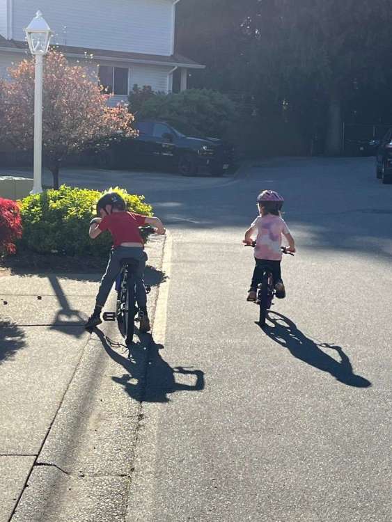
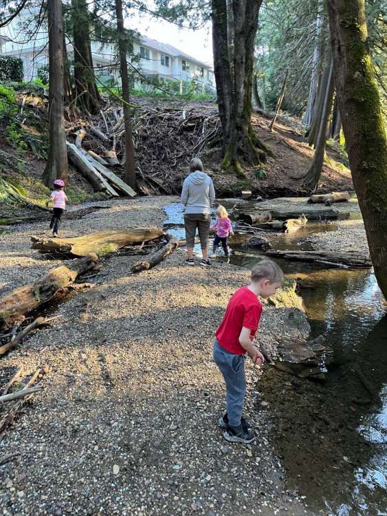
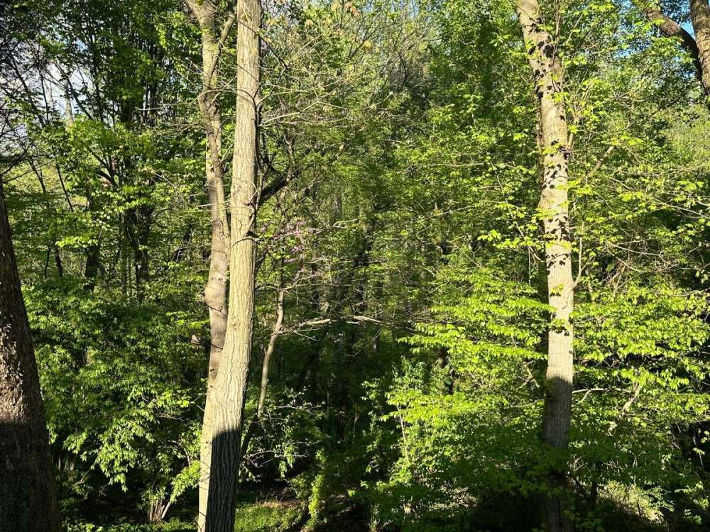
The warm, dry outflow allowed some time for the kids to ride bikes and explore the creek beside our place
 5 points
 -
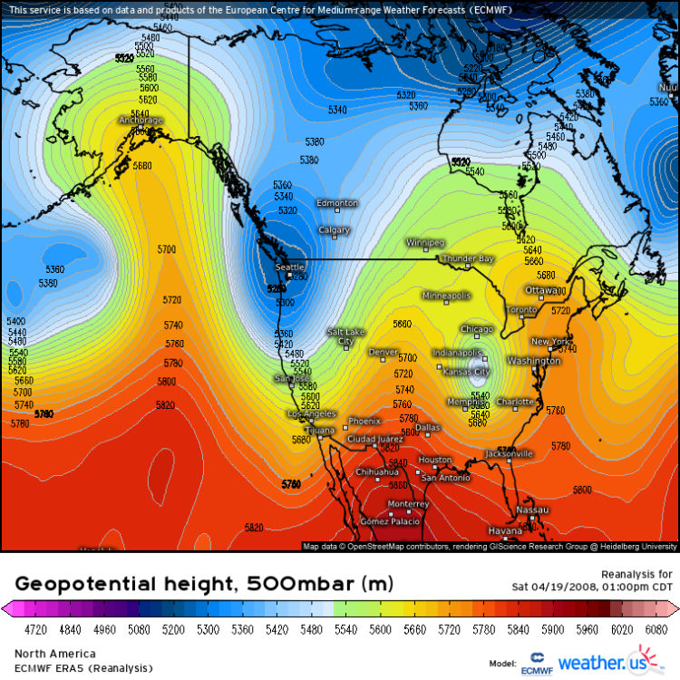
And 16 years ago yesterday I believe Everett got 7” of snow from a CZ.4 points
-
00z EPS looked pretty good overall. Would be nice if it would trend a little wetter.
 4 points
 -
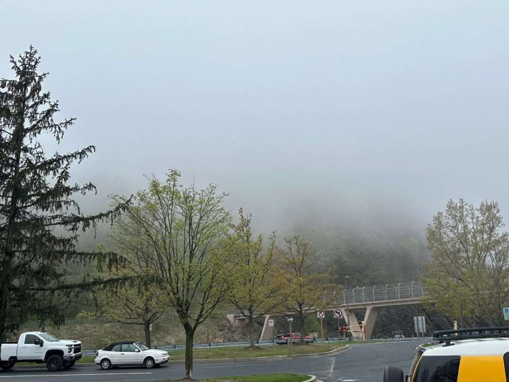
Just below the cloud deck here driving thru Hancock.
 4 points
 -
4 points
-
I can smell the ocean. Immediately knew a PNW-style backdoor marine push had moved thru overnight.4 points
-
16 years ago RIGHT NOW a graupel storm of EPIC proportion was about to decend upon those of us residing in Clark County. Hard to believe this snow pellet party is officially old enough to drive!
 3 points
 -
Welcome back! We just thought you were on warm season hiatus.3 points
-
That pic was at ~ 1200ft. Technically we’d just passed Hancock. Can’t see the terrain because it’s in the cloud deck. But definitely at least 2 weeks behind DC, probably more. Took this yesterday, foliage has been emerging quite rapidly.
 3 points
 -
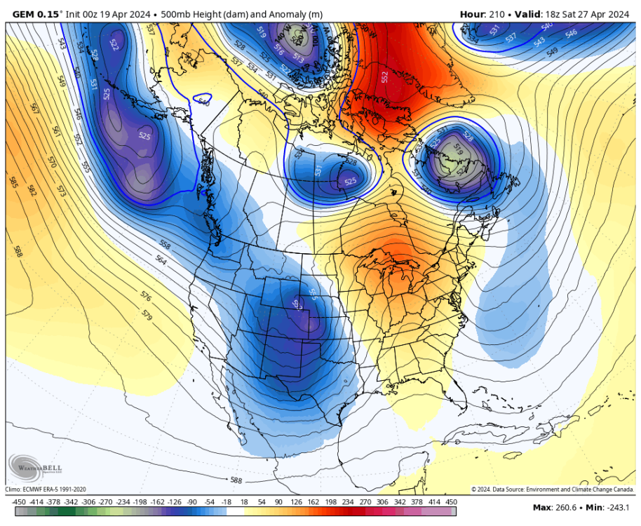
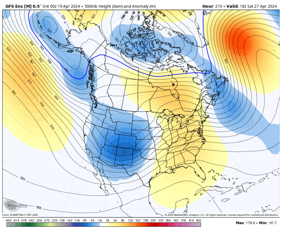
The 00z CMC and GEFS both have that zonal/onshore flow pattern establishing during week-2. A J***e delight.
 3 points
 -
NOAA has been having a rough time lately. Horrible busts last winter on both the seasonal and subseasonal scales. Idk what their methodology is but it’s been failing them since the niño established. IIRC they rely heavily on the IRI which is notoriously bad when seasonal/LF forcing components destructively interfere w/ canonical EOFs (example: strong niño in tandem with -PMM).3 points
-
Great sunset tonight. Cheers from Cashmere!
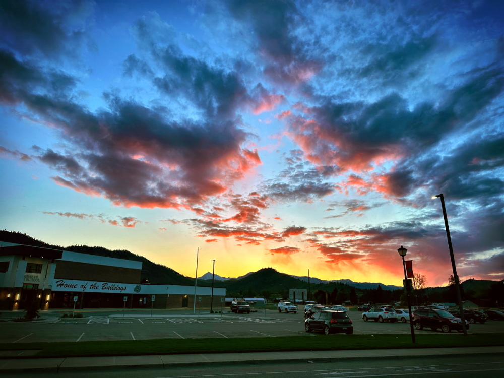 3 points
 -
Whatever3 points
-
Cloud seeding is a form of public relations to say “at least we’re trying” to end droughts. Throwing some silver iodide in a cloud isn’t going to do anything to a storm that is large enough to produce appreciable precipitation. It might cause a few sprinkles from a cumulus cloud that otherwise wouldn’t have rained. There are also legal ramifications since it had been argued that cloud seeding is a form of theft — you are stealing the water from areas downstream of where you seeded. The ironic thing is that project Stormfury got axed in the late 60s after they seeded a hurricane and it happened to make a left turn to the Eastern seaboard shortly thereafter. It would be funny if this makes them think twice about seeding in the UAE, although it’s a bummer that they didn’t seed this storm (or at least they claim to have not seeded it LOL).2 points
-
Looks like a dangerous marine blast incoming for tomorrow! Stock up now!!2 points
-
He says drier in the West but that is not a problem because that area needs to dry out a bit.2 points
-
Pretty good chance that I will stop working before the end of the work day today.2 points
-
Heading out to appalachia for a bachelor party. Will do my very best not to drunk-post this weekend but make no promises.2 points
-
2 points
-
That was my thought. Probably some cool finds.2 points
-
Gusty here as well. We have a wind break that blocks the north wind on the deck and it feels really nice at 62 degrees.2 points
-
Tomorrow's gonna be wild. More akin to what you would see east of the Rockies. Not so sure I've ever seen such a quick pattern progression outside of the summer. 6am: Upper 30s and calm after a clear night. Warmer on the hilltops exposed to east winds, but in the usual sheltered cold spots it should decouple fine. Noon: Low-mid 70s and increasingly breezy out of the east. Main ridge axis overhead. Some filtered sunshine, with fast moving high clouds. It'll be a beautiful morning. 6pm: 50s with increasing rain as a cold front absolutely violates the westside. Some pockets of heavier showers embedded given the warm air ahead of the front. Crazy crash. Midnight: Mid 40s and showery. Not even twelve hours after the main ridge axis passes over does the main axis of our trough glide through. Already starting to warm again above 700mb.1 point
-
Just saw the radar loop. That’s as impressive as it gets. I saw reports of over 6 inches. Looks like the Dubai government said there wasn’t any cloud seeding missions during the storm. They have done it in the past though. I’m not a fan of cloud seeding or any other weather intervention done by man. We need to let Mother Nature run its course. “DUBAI, United Arab Emirates — The National Center of Meteorology, a government task force responsible for cloud seeding missions in the United Arab Emirates, said it had not carried out the weather modification technique in the run-up to the heavy storms that caused flooding in places like Dubai. The organization told CNBC that it did not dispatch pilots for seeding operations before or during the storm that struck the UAE on Tuesday.” https://www.nbcnews.com/news/amp/rcna1482631 point
-
12Z ECMWF is quite a bit drier than its 00Z run.
 1 point
 -
Damp and overcast, picked up 0.01" of light drizzle this morning.1 point
-
Stayed windy all night here which is unusual for this time of year. Made for a very mild low of 52. Warmest of the year so far. Glad that front is coming through tomorrow because this ridging is starting to get stale.1 point
-
That is not in the mountains... only at 564 ft in elevation. The leaf out there is behind here which is surprising because I think its been much warmer there. But it looks like that is quite a bit north of DC so maybe not as warm.1 point
-
Wonder if it might trigger thunderstorms for some areas?1 point
-
Yeah... its going to be quite a change from early afternoon to evening. Pretty unusual.1 point
-
Highs 71. Low 62. Rain on and off throughout the weekend. Feels more like early Spring than April.1 point
-
Eric thinking a Summer quite similar to 20201 point
-
Interesting View from Eric Snodgrass https://youtu.be/UjOA_iTnfP0?feature=shared1 point
-
Honestly I wish the operational GFS didn’t exist. Always shows the most amazing, enjoyable solutions but it never happens. Especially in the spring. 06z has a sexy-af tropopause fold/TPV lobe swinging thru next week but not a single GEFS/EPS/GEPS member has it. Idk how it strays so far off the reservation, but it be trollolololin’.1 point
-
Maybe if we get this pattern out of the way in spring it’ll reverse during the summer.1 point
-
Some weather history for April 19 for Southern Lower Michigan 1957: Less than a week after record low temperatures in the teens, high temperatures are pushing 80 degrees across Lower Michigan. Muskegon went from 19 degrees on the 15th to a high of 79 on this date, a rise of 60 degrees in four days. 1953, the temperature in Flint never rose above 35 degrees. This temperature was a record temperature, in that it was the lowest maximum temperature for that day. The next day, the record lowest maximum temperature for Flint was 34 degrees. 1927, A deadly tornado outbreak occurred across the central part of Illinois, killing 21 people. The first tornado touched down near Hardin, traveling northeast through Carrollton, then skimmed the south side of Springfield. At Carrollton, a teacher was killed as she held the door of the school shut, saving the lives of her students. The second tornado, peaking at estimated F4 intensity, touched down on the southeast side of Springfield, then moved to affect the towns of Riverton, Buffalo Hart, Chestnut, and Cornland. In Buffalo Hart, only three houses were left standing, while the northern half of Cornland was leveled. The tornado track was 65 miles, ending in Ford County 1986, A major storm system produced ten tornadoes in Texas. One of these tornadoes virtually annihilated the town of Sweetwater. The tornado struck at the unlikely time of 7:17 am. One person was killed, and 100 were injured.1 point
-
The tiny areas of extreme drought in upper Idaho and Montana have returned. The extreme area in Iowa has decreased. The drought areas of the Kansas and Oklahoma (very dry) and desert Southwest are expanding to merge in the Texas panhandle. If that trend continues, there will be a continuous line of drought that extends from the boot heel of New Mexico to the upper Great Lakes.
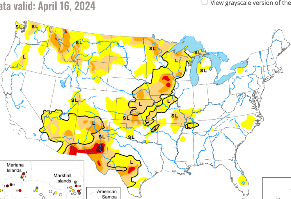 1 point
 -
Yes, they think it started in the attic or from embers from the chimney.1 point
-
Probably our most pleasant summer in a decade.1 point
-
Been saying this for awhile. 2024 will probably be the hottest summer on record for the lower-48. All forcing components are lining up in the worst way possible.1 point
-
16/17 was full blown niño-costero by Feb. Calling that winter a niña borders on criminal.1 point
-
If it makes you feel any better, there hasn't been a major U.S. plane crash since 2009. An amazing testament to how safe air travel has become, almost down to a science. The bigger picture shows that even with the questionable recent record of certain companies, the safeguards are overwhelmingly doing their job.1 point
-
North wind is blowing and a DP of 33 and a RH of 35% Still a dry arctic blast!1 point
-
Here in the Fraser Valley we woke up to a stiff outflow that’s still blowing. That’s likely the source of the N wind. Beautiful here in Mission: sunny, 64F with a dewpoint of 19F with the outflow.1 point
-
It'd be cool if we could view model output (upper level, large scale progression type of stuff/500mb) on 3D maps rather than the 2D distorted projections1 point


This leaderboard is set to Vancouver/GMT-07:00