


Esquimalt
-
Posts
2179 -
Joined
-
Last visited
Posts posted by Esquimalt
-
-
10 minutes ago, VancouverIslandSouth said:
Still a bit early to say, the heaviest precip doesn't arrive until 10~12pm, could be some pretty quick accumulations with that so long as the winds continue to be northerly.
What is going on with environment Canada. 2 cm near the water and meanwhile every model predicts more than 10 cm and we have 5+ cm on the ground here at sea level in esquimalt
-
 1
1
-
 1
1
-
-
Anyone have the 00Z HRDPS snowfall maps? Looking good?
-
1
-
-
8 minutes ago, Hawksfan2008 said:
Interesting…HRDPS actually increases totals for quite a few areas
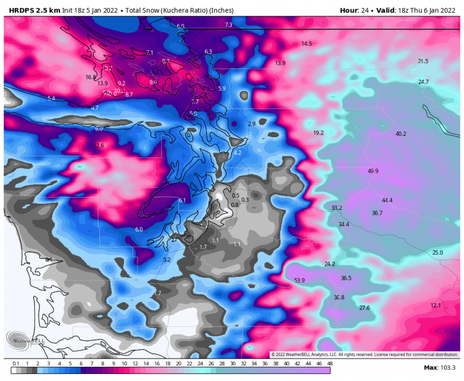
10 inches over my house. Gfs and wrf shows 10 as well. Euro shows 3. Who to believe lol
-
1
-
 1
1
-
-
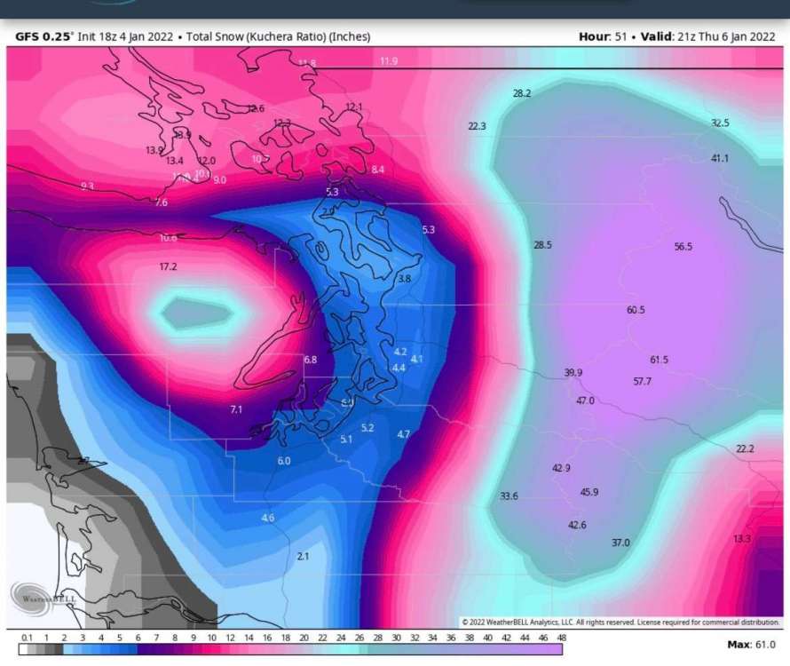
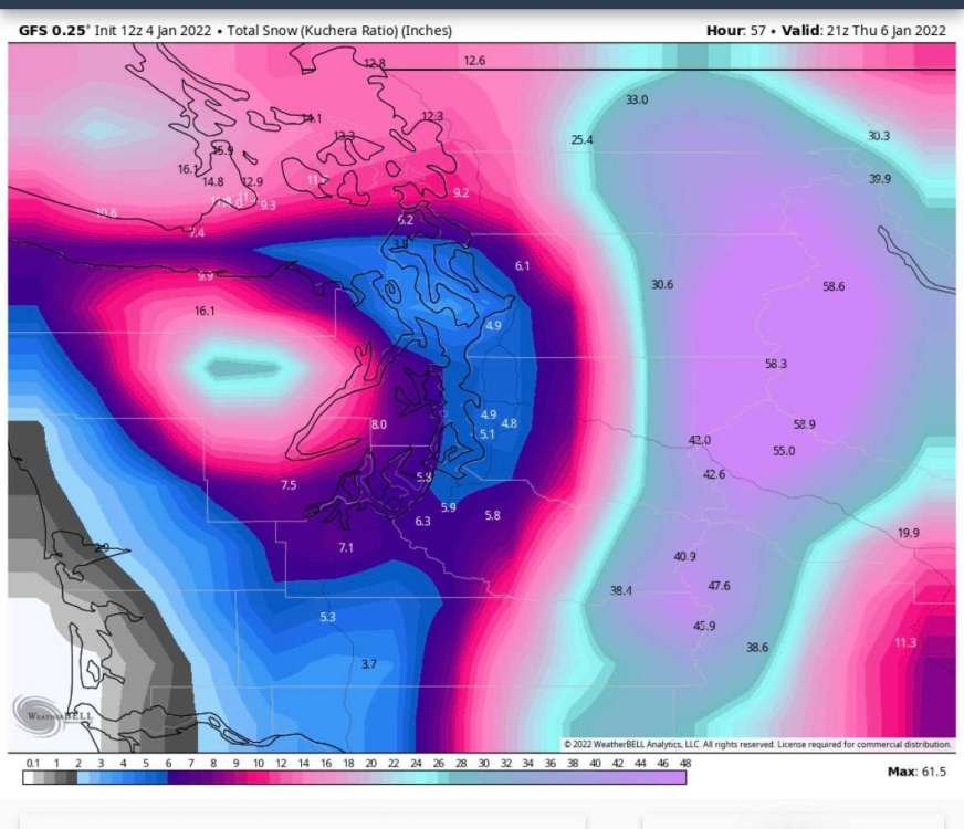
How is it that the wrf and the gfs show me getting 8-10 inches and the RGEM and euro show me getting 3 lol? I’ve never had a situation where within 12 hours of the event theres been that much variation
-
8 minutes ago, VancouverIslandSouth said:
Eagerly awaiting the arrival of that Fraser Valley outflow, still 35F here with light SW winds. It seems this might be one of those tight snow gradient scenarios, the Arctic air is arriving at just the right time to meet a Pacific storm. Places that end up near the boundary will see huge amounts of snow. Hope is sitting at 16F now with blasting outflow, this Fraser Valley airmass is plenty cold.
What are you expecting tomorrow? I was initially very bullish on this setup but everything except the gfs has pulled back significantly?
-
12 minutes ago, SouthHillFrosty said:
Pullback definitely starting to show up on the GFS.
How did the euro look like for this event?
-
1 hour ago, TT-SEA said:
Its 37 degrees in North Bend this morning and schools are closed. Can't keep that up. That is the normal low in the winter.

Do you have the 06Z euro snow maps?
-
Just now, ShawniganLake said:
Bad. Really bad. But pretty unlikely on the island. Never seen anything close to that here even when we transition out of strong arctic air masses
I’m encouraged that the euro and gem show mostly snow. What do you see happening in vic on Thursday?
-
1
-
-
An inch of freezing rain on the gfs this morning here continuing the trend of thrursday’s event being snow to freezing rain. Any clue how damaging that much freezing rain would be?
-
1
-
-
Wow huge improvement on the Gefs
-
7
-
-
Just now, Joshua Lake Oswego said:
We all know that lows end up a few hundred miles north of where they are originally forecasted. No chance for Oregon.
I like my odds up here.
-
1
-
-
GEM a decent bit further north tonight lol. Let’s see what the ukie says
-
1
-
 1
1
-
-
The second low is too south in this run
-
 2
2
-
-
5 minutes ago, VancouverIslandSouth said:
The lack of wind here has been amazing given the large pool of cold air nearby. Currently 31F with virtually no wind after a sunny windless 35F high here, typically such conditions would be accompanied by roaring outflow winds.
Looking like it’s friday night or bust here. The southerly trend tonight is undeniable
-
1
-
-
1 minute ago, Bryant said:
Let's see these 00z models shift north
I love how divided this forum is lol
-
2
-
 1
1
-
2
-
2
-
-
3 minutes ago, OysterPrintout said:
How does that compare to the 12z?
-
Any update from the eps?
-
1 minute ago, MR.SNOWMIZER said:
I'd say about 50 miles south of the 12z.
I’ll say 30 miles north
-
1
-
-
Just now, RentonHillTC said:
Although there does seem to be much better agreement with 18z GEFS low locations.

Looks like there was a lot of agreement on the 06Z too lol
-
Stays impressively cold with this one
-
RGEM decent leap north
-
1
-
1
-
-
3 minutes ago, BLI snowman said:
Sure, not to mention March 2012 and even some of the weak stuff that we had in 2012-13.
It's not really about "winning" so much as it's about being left with so little while so much is going on a relatively short distance away. It'd be different if we had a couple more 2-3" events to show for the last few years. My snowiest event since 2018 was in fact last Pi Day! A fairly unusual stretch of ineptitude in the midst of other places seeing some really big totals.
Yeah these things come in waves. I remember a 10+ inch storm in Feb2017, Feb2019 and Jan2020 (and now possibly this week again). But before that we’d have to go back to 2014 or 2011 to get anything that big up here
-
No one should be looking at the 18Z HRRR. Disgusting lol
-
2 minutes ago, hawkstwelve said:
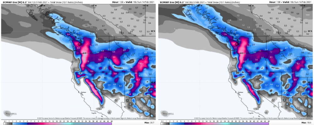
By Sunday morning, 12z vs 00z EPS snowfall mean...
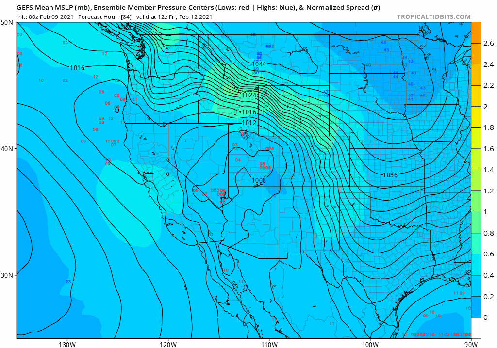
Do you mind posting the ensemble member mlsp's for the sunday evening event?
-
1
-


PNW January 2022, Contact Info for Phil
in West of the Rockies
Posted
About 6 inches at sea level in Esquimalt, and the precip has turned to sleet. Gonna get an official measurement a little later. Pretty impressive for an event 24 hours ago seemed might be rain.