


weatherfan2012
-
Posts
1478 -
Joined
-
Last visited
-
Days Won
1
Posts posted by weatherfan2012
-
-
4 hours ago, Phil said:
I’m not sure the GEFS “won” since it was projecting a prolonged, 7+ day trough, while in reality it’ll be a transient 2-3 day event followed by another prograding heat ridge.
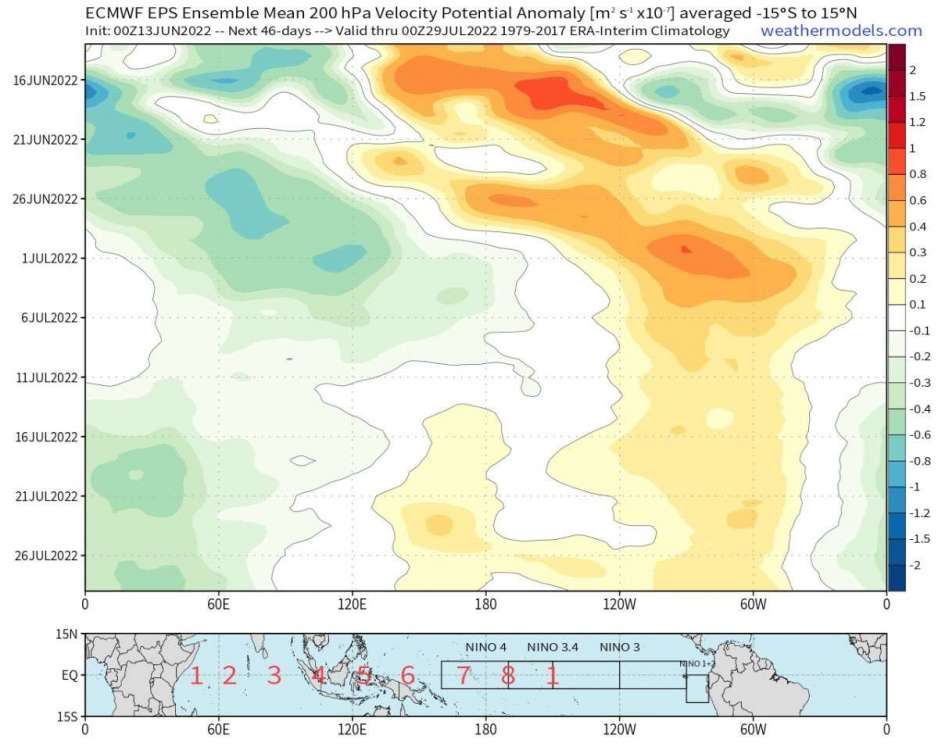
I have hope the first half of July will offer a “break” in the heat as upper level divergence reaches the dateline. But the 2nd half of July looks brutal again, with IO forcing/W-Pacific subsidence taking over.

Larry Cosgrove is still in eather the warm neutul to weak El Nino idea this fall.whats he seeing your have to ask him that question.
-
18 hours ago, Phil said:
Culmination of factors. That La Niña was also collapsing rapidly during the spring, while this one was/is strengthening.
1988 might be a better ENSO analog as that Niña was borderline strong by summer. This one will also likely be the strongest since 1999 during boreal summer.
And Larry Cosgrove is still on the weak El nino by fall if you can beleave that.Nothing against cosgrove just wonder what it is he seeing.
-
1 hour ago, Phil said:
I’m not nearly as optimistic about cool summer weather as some. Large scale subsidence over the West-Central Pacific, if indeed that is the low pass signal, does not bode well for deep troughing as we get deeper into the the warm season. Upper level divergence has had a tendency to fill the W-Hem/IO-IPWP sector this spring, which can be a cool/changeable pattern for the CONUS early on, but becomes hotter/drier with time as seasonal teleconnections evolve.
Of course there are many variables involved. Not a slam dunk by any means. But I know where I’m placing my bets.
Also must factor in things are running about a month late it would seem the last few years or so.
-
 1
1
-
-
Round 2 of thunderstorms moving through can see the storm lighting to the southeast.
-
3
-
-
14 minutes ago, Meatyorologist said:
The tropical-midlatitude coupling is undoubtedly stronger than last year and arguably any year in decades. A totally different animal, since summer last year resembled more of a warped +ENSO hybrid w/ a front loaded warm season (no duh) gradually tapering into some chiller late August weather. Every month ran warm in the PNW, with several locations (KGEG, KEUG, KSLE, ect) setting records for all time seasonal warmth. Western ridging was absurd and quite literally all time record breaking.
This time last year we were looking forward to a major heat wave on the horizon to ring in June, shortly after reaching 70°F at KSEA for six straight days mid May. April was overwhelmingly ridgy and reached 80°F on the 17th, and 70°F eight times in total including a week straight. I think you'll be the first to agree that -ENSO isn't the whole story, and that last year was a great example of that. But for whatever reason, this warm season seems to be directly tied with the current La Niña regime and this 'mode' of the atmosphere doesn't seem to want to end any time soon. It happens around once every decade or so given 2010/11, 1999/00/01, 1983/84, ect. This upcoming cold season may very well continue a Pacific dominated regime, not necessarily Arctic.
The thing I'm lost on is why Larry Cosgrove is so certain on a weak El Nino end of summer fall I have alot of respect for him as he is a great met but I'm just not sure what it is that he is seeing to be forecasting that.It has made for some interesting comments on his facebook page as some are asking him what he thinks of the on going La nina.
-
 1
1
-
 1
1
-
-
On 5/19/2022 at 8:23 PM, Phil said:
First heatwave of the summer a cometh. Low 90s likely tomorrow, while upper 90s to near 100°F are possible over the weekend.
Unfortunately convection looks capped/confined mostly to the high terrain. Sucks.
At least until sunday then chances start to go up as we break down the heat.
-
 1
1
-
-
1 hour ago, Phil said:
Today’s severe threat totally flopped here. Pre-frontal crapvection blew through way too early.

The models were way to slow with this system the storms yesterday came in a few hours faster as well looks to me that the models errored to slow this time.The good news if Larry Cosgrove idea of the core ridge in the west southwest this summer we should have plently of opportunities for some good thunderstorm events.
-
1
-
-
31 minutes ago, TT-SEA said:
This 3-year Nina is doing wonders. The western US is completely out of balance.
I notice the other day people were pissed with Larry Cosgrove in his comments section because he against the La nina ideas lol he still forecasting weak El nino by end of summer.
-
30 minutes ago, Andie said:
Texas straddles a couple lines.
The SW crowd and the S Central bunch. Then there are the NW cold fronts and Hurricanes.
In short, we’re in the “sweet spot”.It can suck.
In truth that sweet spot isnt sweet at all.
-
 2
2
-
-
14 hours ago, Phil said:
Going to be a death ridge summer, I’m afraid.
Cosgrove is forecasting the core of the heat to be in the southwest and west this summer so Texas does sound to be in the oven this summer
-
5 hours ago, Phil said:
Super Niña coming?
I asked steve his opinion on what Larry has been saying Steves weather page he said he agrees with Larry Cosgrove
 I just phil can not understand what it is that there looking at but I will kindly have my crow if there proven right.
-
1
-
-
4 minutes ago, Phil said:
I’ll eat a bug and post the video here if that happens.
Agreed lol
-
 1
1
-
-
6 hours ago, Phil said:
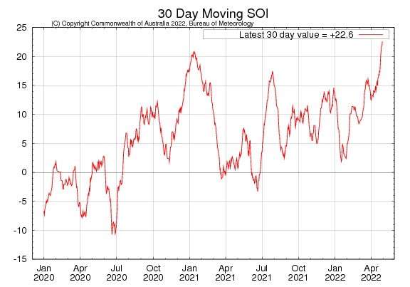
The 30-day averaged SOI is more positive now than it was at any time during the winter.
Larry Cosgrove is still somehow convince that we go weak el nino by late summer.we will see
-
1
-
 1
1
-
-
On 4/27/2022 at 10:09 AM, Iceresistance said:
Goodness, it's coming back with a Vengeance!
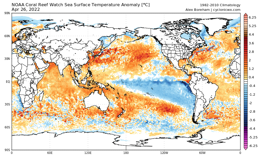
Larry Cosgrove thinks it is weaking https://www.linkedin.com/feed/update/urn:li:share:6925431474506661888/ not sure what he is looking at but he a old school forecaster.
-
1 hour ago, Phil said:
Yeah that almost certainly isn’t happening.
In fact this is the first year I can remember without any “spring barrier” issues in seasonal guidance. Mostly because the system state is so deeply entrenched in its La Niña state. Usually ENSO weakens during the warm season, but might not be the case this year.
Which begins the question of what exackly Larry is seeing to lead him to beleave a weak El nino and I'm a cosgrove fan but his line of thinking is confusing giving the Data.nothing against the guy a great respected forecaster just would like to see what he seeing.
-
1
-
-
5 hours ago, Phil said:
Pretty insane +SOI numbers now.
https://www.longpaddock.qld.gov.au/soi/
The 30 and 90 day combined average is actually the highest it’s been since the start of this La Niña in 2020. Crazy stuff.
What funny is Larry Cosgrove is still very much on the weak El nino train for end of summer fall.
-
On 3/29/2022 at 4:50 PM, OKwx2k4 said:
Yeah, that Niño hope really crashed in weeks. So crazy.
I'm wondering if I don't experience a July this summer that's "polar" opposite of my December 2021.
Larry Cosgrove is still convince a west basen Weak El nino end of summer someone asked him if he was still thinking El nino on his Facebook page.so it will be interesting to see if he ends up right sure is interesting he going against the grain.
-
7 hours ago, Phil said:
At some point we’ll see a +MT/+dAAMt dampen this La Niña background state (which is normal..saw it in both 2011 and 2008, as well) but that process may actually perpetuate the cool pattern in the West as seasonal dynamics/relationships change quickly during the spring.
At the very least, it’s a much healthier and more stable -ENSO regime than last year. Possibly the most impressive since 1999. Going to be tough to climb out of this. And we probably won’t climb out of it...odds of a 3rd year -ENSO are increasing.
Larry Cosgrove has been catching alot of heat from people because he predicting neutral to weak El nino by late summer lol.
-
 1
1
-
-
9 minutes ago, MossMan said:
Is he the Oregon version of Rich Marriott?
Larry is living in Texas now he use to be the head forecaster in Cleveland a long time ago when he had dark hair he also did a station with New york for a time.He and Dave Tolleris WxRisk.com use to get into some very heated exchanges he has sense block Dave on all forums of media.He writes a column called weather America every weekend.
-
It's funny that cosgrove would see La nina breaking down when data does not support that at least right now.He eather going to be a genus or he going to have alot of crow to eat in the coming months.
-
2
-
-
Larry Cosgrove is still very much in the weak El nino train https://www.linkedin.com/m/feed/update/urn:li:share:6916237145888198656/ his weather America letter.
-
1
-
 1
1
-
-
4 hours ago, Phil said:
Oh yeah, -ENSO base state is rock solid at the moment.
How that translates to warm season patterns is less clear. We’re still in the post-1998 z-cell/WP era, after all.
But it can be overcome, as 2008-12 demonstrates. We’ll see what happens. This is the closest we’ve been since then.
It will be interesting to see if Larry Cosgrove concedes or if he is still on the El nino train in the fall in his weather America tonight.
-
1
-
1
-
-
2 hours ago, Phil said:
Could be. Tbh I suspect most of the convection will be low topped around here, as there’s a lot of prefrontal crapvection limiting instability. All dynamics driven.
That said the wind is gusting around 40mph despite cloudcover/WAA so there’s a lot of momentum available for downward transport, should it happen.
Which is very typical with our early spring severe weather set ups they tend to be low top squall lines with damaging wind gust,sometimes these type of storms have littie if any lighting and thunder with them. It's the oppersite in the late spring summer storms become prolific lighting producers.
-
1
-
-
15 hours ago, Andie said:
Another dry drought ridden winter.

I'm not sure what Cosgrove is seeing with his El Nino idea.
June 2022 - Summer Begins
in West of the Rockies
Posted
If you asked Larry Cosgrove he would say the La nina is weaking and going warm neutral possbly weak El nino this fall What he seeing your have to ask him on his facebook page.