

Requiem
-
Posts
6891 -
Joined
-
Last visited
-
Days Won
3
Everything posted by Requiem
-

January 2024 Weather in the PNW (Part II)
Requiem replied to Meatyorologist's topic in West of the Rockies
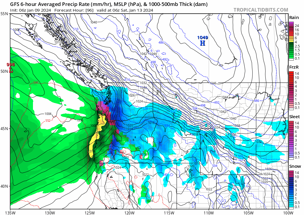
I have a feeling it's being a bit too anemic with precip-- Euro actually has quite a bit, it just happens to fall as ZR -
January 2024 Weather in the PNW (Part II)
Requiem replied to Meatyorologist's topic in West of the Rockies
-
January 2024 Weather in the PNW (Part II)
Requiem replied to Meatyorologist's topic in West of the Rockies
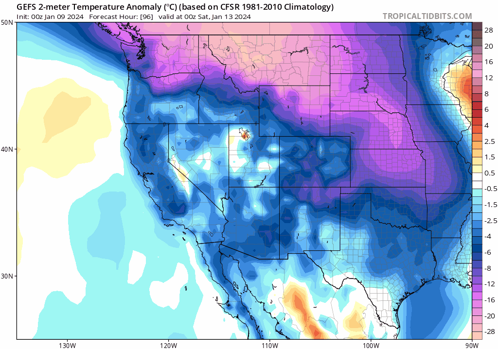
Cold air a hair south on the 06z -
January 2024 Weather in the PNW (Part II)
Requiem replied to Meatyorologist's topic in West of the Rockies
Yo Eugene folks-- surprised it wasn't mentioned but the South Valley gets a nasty ice storm this run. I was confused by the snow totals as precip was actually increased from the 00z last night (shifted south, however)-- it appears a lot of that falls as ZR. -
January 2024 Weather in the PNW (Part II)
Requiem replied to Meatyorologist's topic in West of the Rockies
So I looked back at that December 2009 event out of curiosity-- interesting to see how little Gorge influence that one featured. Mark's old blogs featured many comparisons to 1998-- save for the raging easterly winds, which 2009 was apparently bereft of. -
January 2024 Weather in the PNW (Part II)
Requiem replied to Meatyorologist's topic in West of the Rockies
Well... sorta? That was mostly a nightmare if I recall because cyclogenesis screwed the pattern up and sent lows so far north that it turned into a minimal event in the end -
January 2024 Weather in the PNW (Part II)
Requiem replied to Meatyorologist's topic in West of the Rockies
The Euro also showed lows going south of the region until maybe a day or two before the event. -
January 2024 Weather in the PNW (Part II)
Requiem replied to Meatyorologist's topic in West of the Rockies
This run features a rather absurd 15 mb PDX-DLS gradient, as well as a 32 mb OTH-GEG gradient... that would be pretty insane. Also explicitly models gusts in excess of 75 mph in the Gorge, which I've never seen from a global model. -
January 2024 Weather in the PNW (Part II)
Requiem replied to Meatyorologist's topic in West of the Rockies
I'm also thinking that. GEM and GFS like a more battleground type event with a pretty sharp temp gradient-- EURO on the other hand is much colder and like 2014 shifts those lows very far south. -
January 2024 Weather in the PNW (Part II)
Requiem replied to Meatyorologist's topic in West of the Rockies
I'm sure Euro will swing north... but maybe at face value this gets Eugene in on some arctic fun -
January 2024 Weather in the PNW (Part II)
Requiem replied to Meatyorologist's topic in West of the Rockies
Apparently fully snowing back home-- reminds me of a less potent but more timely April 2022 -
January 2024 Weather in the PNW (Part II)
Requiem replied to Meatyorologist's topic in West of the Rockies
Wow it's coming down over there -
January 2024 Weather in the PNW (Part II)
Requiem replied to Meatyorologist's topic in West of the Rockies
Last winter was pretty great-- one of the more impactful southerly windstorms I can recall in recent memory, a significant ice storm, and of course what I think may be one of the greatest PDX snowstorms of at least the 21st century. -
January 2024 Weather in the PNW (Part II)
Requiem replied to Meatyorologist's topic in West of the Rockies
Wow! -
January 2024 Weather in the PNW (Part II)
Requiem replied to Meatyorologist's topic in West of the Rockies
Tichner and Burnside up by Washington Park seems to be all snow on the cams. Looks like Sylvan has also switched over. -
January 2024 Weather in the PNW (Part II)
Requiem replied to Meatyorologist's topic in West of the Rockies
I do not believe it will be one of the biggest single storms in Portland or the WV, but it will be a very impactful and significant system nonetheless and someone's gonna get slammed with a foot of snow somewhere. -
January 2024 Weather in the PNW (Part II)
Requiem replied to Meatyorologist's topic in West of the Rockies
-
January 2024 Weather in the PNW (Part II)
Requiem replied to Meatyorologist's topic in West of the Rockies
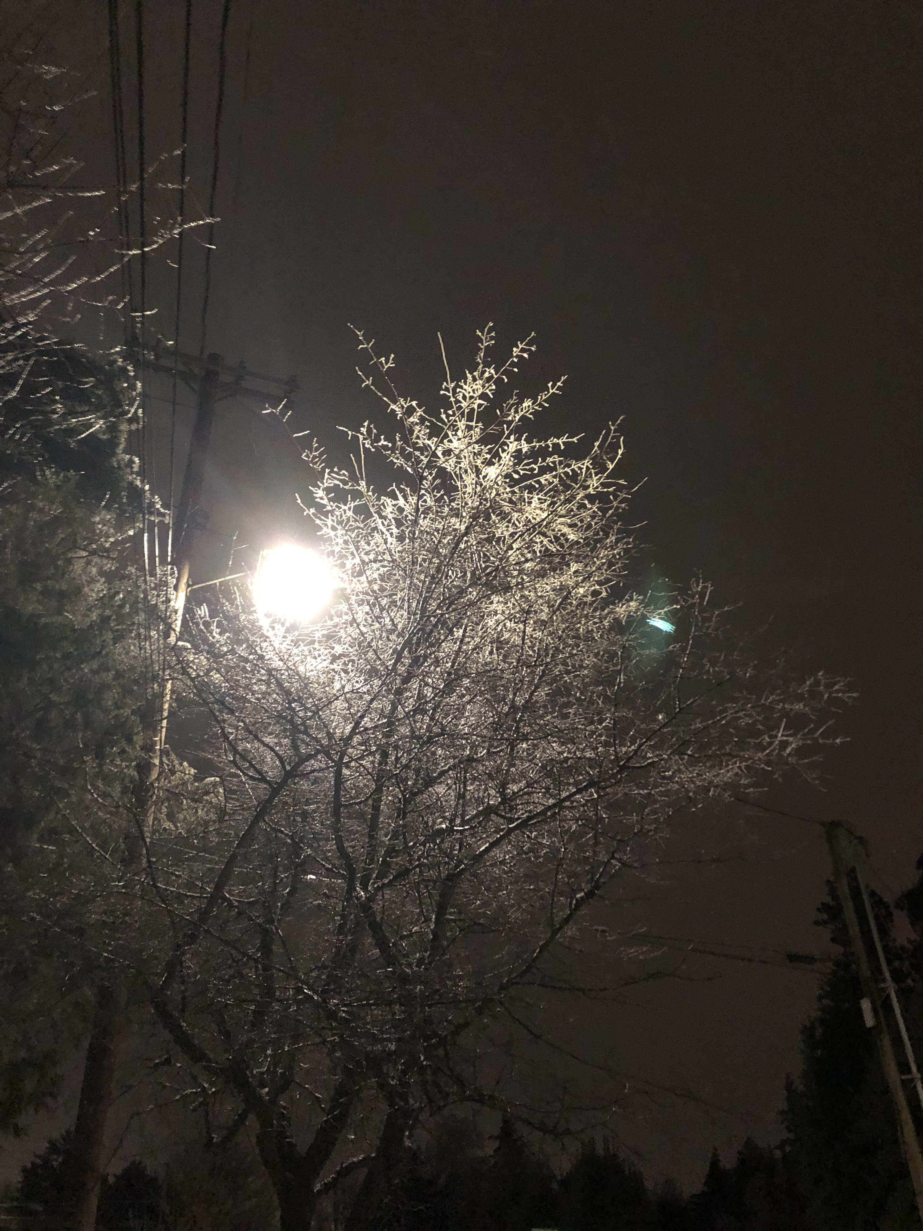
Snow at Gales Creek -
January 2024 Weather in the PNW (Part II)
Requiem replied to Meatyorologist's topic in West of the Rockies
Has a blizzard warning ever been issued for the immediate metro area? 2008, maybe? 2004? -
January 2024 Weather in the PNW (Part II)
Requiem replied to Meatyorologist's topic in West of the Rockies
This is a fantastic run for Seattle -
January 2024 Weather in the PNW (Part II)
Requiem replied to Meatyorologist's topic in West of the Rockies
It will be very cathartic to see my 2/2021 prediction come true pls models -
January 2024 Weather in the PNW (Part II)
Requiem replied to Meatyorologist's topic in West of the Rockies
GFS is definitely more aggressive w the cold -
January 2024 Weather in the PNW (Part II)
Requiem replied to Meatyorologist's topic in West of the Rockies
Portland people... (and EPSL people too to some extent)-- it's worth noting that several models are showing insanely strong easterly winds as the gradient rises on the Euro to as much as -15 mb PDX-DLS. There would be somewhat of a downslope element to thus as well. Could be a rough go east metro and west hills, I've actually never seen a model explicitly forecast gusts of over 70 mph for the Gorge. -
January 2024 Weather in the PNW (Part II)
Requiem replied to Meatyorologist's topic in West of the Rockies
With the first low it is slightly further north than the 12z, but precip this run still doesn't actually make it into the PDX metro or across the state line. Not too concerned, these lows always have a pretty robust and further north than modeled precip shield. -
January 2024 Weather in the PNW (Part II)
Requiem replied to Meatyorologist's topic in West of the Rockies
That to me seems like the theme of today-- models not doing anything new, but reverting to their solutions several runs before and back again.


