NEJeremy
-
Posts
1896 -
Joined
-
Last visited
-
Days Won
9
Everything posted by NEJeremy
-
Discussion For The 2018-19 Autumn & Winter Seasons
NEJeremy replied to Minny_Weather's topic in East of the Rockies
Yeah I remember the snowpack sticking around forever. Set records I believe -
Discussion For The 2018-19 Autumn & Winter Seasons
NEJeremy replied to Minny_Weather's topic in East of the Rockies
Sorry for the dumb question I guess. I'm aware of global temps and US temps being totally different. I had inferred that low sunspot activity meant the planet would be cooler, not just part of one continent. The statistic about Lincoln came up when I was trying to refresh my memory what things were like around here back in 2009 during the last low sunspot activity and thought it was a pretty cool stat since that was only the 2nd time in 125 years of record keeping that the average November temp was higher than October. -
Discussion For The 2018-19 Autumn & Winter Seasons
NEJeremy replied to Minny_Weather's topic in East of the Rockies
Question on something I'm not understanding. If sunspots are a precursor of cold conditions, how come when the last time the sunspots were nonexistent in the late 2000s, temperatures were still so warm? At the time 2009 was the 2nd warmest year for the planet and 2010 was tied for the warmest with 2005. I know sunspots are only one part of the formula, but talking about a Nino normally also means warmer than normal conditions here as well. Winter 2009-2010 is infamous here for the amount of snow we had in December, but it was warmer than normal leading up to December and most of the snow for the winter fell in December and early January if I remember correctly. Found this interesting stat for Lincoln: November 2009 high temperatures in Lincoln averaged 1.9 F warmer than October 2009! How rare is this to have November be warmer than October in Lincoln, NE? Very rare. In fact this has only occurred once before in the 123 years of data (1887-2009) for Lincoln and that was in 1925 when November 1925 average high temperatures were 0.2 F warmer than the previous month October 1925. -
seeing pretty strong damage pics from Pella. There was a tornado emergency in Marshalltown a bit ago
-
Discussion For The 2018-19 Autumn & Winter Seasons
NEJeremy replied to Minny_Weather's topic in East of the Rockies
It's weird how winter weather sites that are run by winter weather enthusiasts always all say that... I already know what the winter weather forecasts are going to say each year -
I was lucky and got .76” of rain from the early storms, but disappointed to see everything pushed off to the south. Looks like nothing now until mid week
-
98/67/102 It's hot, and I love it
-
Discussion For The 2018-19 Autumn & Winter Seasons
NEJeremy replied to Minny_Weather's topic in East of the Rockies
I'm going to go out on a limb and say, who knows what's going to happen? Last winter was supposed to be epic everywhere based on the models, indices, and analogs, and we ended up with 18" of snow total and most areas were below or near normal for snowfall for the season. Spring took a while to get here and there was some extreme cold in January, but overall it was a pretty benign winter. This summer was supposed to begin hot and dry with talks of a severe drought kicking in especially out here in the Plains, and instead a lot of areas have had record rainfall and flooding and still the heat. All I know is I am done telling my relatives/friends what the upcoming winter is going to be like in the fall. They've stopped believing me -
https://www.washingtonpost.com/news/capital-weather-gang/wp/2018/07/03/hot-planet-all-time-heat-records-have-been-set-all-over-the-world-in-last-week/?noredirect=on&utm_term=.acace9adf9ca
-
Chased 6/30 in south central Nebraska. Unfortunately, made it to the storm about 10 minutes after the last tornado with this storm touched down. Kind of surprising as the storm continued to look amazing on radar and was in a great environment to continue to produce. It did try one more time, but other than that didn't come close. Storm was eventually killed off by a new storm that moved in from the south and we chased that storm to the east for quite a while. This storm was also very pretty, but never came close to producing a tornado.
-
I chased today and I'm ready for 2018 to be done with. Any chase is always nice to be out, but the lack of "luck" this year with tornadoes has been maddening. The models were kind of all over the place with both location and severity of the storms. So my partner and I initially headed for Columbus with an idea we would maybe drop south to York. So we headed towards Columbus. Made it there and storms fired a bit earlier than expected and were way back southwest of Grand Island. So we had to make a break for those storms. Made it to Minden where the last confirmed tornado touched down no more than 10 minutes before we got there. Ran into a chaser that saw 3 tornadoes. Storm remained very strong and well organized with a good looking hook, etc. for over an hour, but didn't produce another tornado. Came very close one more time with a bowl funnel and dust being kicked up from the RFD and rising up towards the base of the storm. Had AMAZING structure too. Will post some pics when I get a chance. To add insult to injury this year, I thought I had my video camera recording when the storm came so close to producing, but I didn't and then when I put the camcorder back in the vehicle when we were leaving, I hit the record button so I ended up getting a 10 minute video of the back seat after we left the storm for a bit to reposition. Unbelievable....
-
Des Moines is under a flash flood emergency. Numerous rescues are taking place. I was listening to the scanner and it is nuts over there. Heard talk of a Hobby Lobby with it's roof collapsed, trees and powerlines down, roads washed out, cars on top of each other, and people asking to be rescued from their houses/apartments.
-
Ha! My wife is from Humboldt. I spent many a day there years ago....
-
Next week looks BRUTAL again for several days after a brief "cool down" for a couple of days coming up. GFS is forecasting dews in the 80s and heat indexes of 110+. Just in time for our family's camping trip
-
Had another .49" from yesterday afternoon and then overnight last night. Storm total since Monday afternoon is 6.08"
-
1.34” from overnight. Total since Monday afternoon is now 5.61”
-
And here we go! Making a very quick run towards 6” total at the rate it’s coming down. Pretty crazy CG strikes too with lots of very loud thunder
-
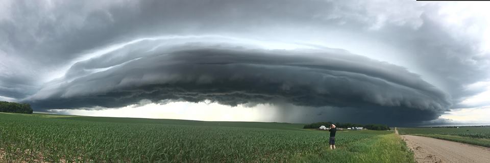
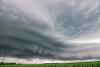
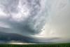
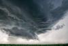
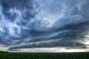
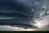
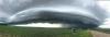
What was kind of cool/different about the shelf cloud, was behind the southern 1/2 or basically the left half of the shelf cloud there was no precip and barely even any clouds. You could see some blue sky behind it. Usually the shelf cloud has precip/clouds behind the whole length of it. Was very impressive!
-
Took this pic on my iPhone yesterday out chasing. Will work on some more of my pics soon
-
I had an additional 2.22" of rain overnight so that makes 4.27" of rain since yesterday afternoon. Looks like a break most of the day before the next heavy wave comes tonight and tomorrow. Could see those totals doubled. Some flooding in west Omaha near Elkhorn. I saw the PW from the ovenight sounding was 2.16" which is believed to be a record for the date. Normally you get all this rain and it clears out the atmosphere. Not this morning, the air is still THICK with moisture so storms will be very efficient with heavy rainfall.
-
Had 2.05” of rain at my house from the storms this afternoon. I was out chasing so wasn’t home for it, but I believe most of that fell in less than an hour here.
-
I agree with you 1000% on heat vs cold If it could snow all the time at 30 degrees, I'd take that in a second. Otherwise give me spring/summer weather all the time!
-
Wowza- look at the forecast heat indexes on the 0Z GFS from last night. Yeah yeah I know, it's 360 hours away, but still crazy to see.... 120+ degrees in eastern NoDak! Mid 80's dews over a lot of the upper Midwest.
-
Outflow from the storms way over eastern Iowa created a special weather statement earlier today for western IA and eastern NE for wind gusts up to 50 mph. Cooler air and lower dewpoints have stuck around here in Omaha. We're only in the mid 80s with low 60s dews. About 70 miles west of here, Columbus is in the 90s with a dewpoint of 70. You can see the outflow boundary clearly on radar too.
-
mid/high level clouds this morning have held temps in check a little so far, should still hit the mid 90s though I would guess. dewpoints fell all the way to the 50s yesterday afternoon but have surged back to the low 70s already this morning which will help us from hitting 100 like we did a few weeks ago when the dews were lower. Looks like a lot of rainfall potential for some areas with slow moving storms next week. I have a feeling things will be to the west and north of Omaha though for the most part. Severe threat next week in the Plains looks almost nil as winds are VERY anemic throughout almost the whole atmospheric profile. Most days have less than 10-15 knots of flow 500mb and down to the surface. Of course this will also be the reason why storms will be creeping along. Big CAPE might produce some pulse severe storms but nothing too crazy I don't think.