


James Jones
-
Posts
871 -
Joined
-
Last visited
Everything posted by James Jones
-
On the 7th month of... July PNW 2022 (Preferance Wars)
James Jones replied to The Blob's topic in West of the Rockies
'03-'04 was my favorite winter ever, but from an objective standpoint '16-'17 is probably the best of my lifetime. Multiple snow events, consistently cold throughout including the first truly cold January in decades, and of course the heavy thundersnow event followed by a week of subfreezing highs. '03-'04 was magical though. It had been 6 years at that point since we had a major snow event, which as a 12 year old weenie might has well have been forever. -
On the 7th month of... July PNW 2022 (Preferance Wars)
James Jones replied to The Blob's topic in West of the Rockies
Cue the soliloquy from Tim about how the Earth was once molten rock and how alligators used to live in the arctic, which means everything is fine. Given the ridiculous heatwaves we're seeing around the midlatitudes it feels like it's only a matter of time before we see 110 degree heat again. If we're lucky maybe before the decade is even out! -
On the 7th month of... July PNW 2022 (Preferance Wars)
James Jones replied to The Blob's topic in West of the Rockies
Hmm, I'm not sure that's true. August has seen comparable anomalies on both sides of the mountains in recent years for the most part. September has largely been reasonable though. Really haven't seen that month torch since 2014. https://hprcc.unl.edu/maps.php?map=ACISClimateMaps -
On the 7th month of... July PNW 2022 (Preferance Wars)
James Jones replied to The Blob's topic in West of the Rockies
It's pretty mind blowing how much our summers have warmed. I was fully expecting this one to be cool (at least by recent standards) but it looks very unlikely to finish below even the roided 1991-2020 averages at this point, at least for the Willamette Valley. It's like we've hit a tipping point where our midsummer weather is now mostly driven by an expanded four corners high. Downtown Portland once had an average high of 69.1 in August! Even getting a sub 80 average high for that month seems like a huge longshot now. -
On the 7th month of... July PNW 2022 (Preferance Wars)
James Jones replied to The Blob's topic in West of the Rockies
I've seen them a few times before but never that striking. Is there a Tonga connection? -
I don't think it's even a modern phenomenon. Our coldest summer months historically have been quite cloudy for the most part which you can determine fairly easily looking at diurnal ranges, and usually have a lot of days with rain at least by the standards of our summer climo. There are exceptions of course, but very sunny and notably cool summer months have always been rare.
-
I get the desire to counter Tim but I think this spring is more impressive than some are giving it credit for, at least since the second week of April. April was one of the wettest on record for the region, we had an unprecedented snow event even going back to the 1870s (maybe something similar happened before that? Justin would probably know) and it's been persistently below normal with only very brief interludes of warmer than normal. PDX hasn't gotten above 75 yet which I imagine is pretty rare by this point in this spring, though I don't have time to check at the moment. Overall it hasn't been historic aside from the snow event, but I think it's still been pretty impressive.
-
Yeah I'm worried about that too in Lake Oswego. I got completely owned in February 2021 but at least this time there's no freezing rain.
-
Looks like PDX has locked up its first sub 50 April high temp in a decade. Tomorrow's record low max of 50 should go down easily too.
- 4519 replies
-
- 13
-

-

-

-

-
Given the drought the West is facing it wouldn't surprise me if we had another Dust Bowl type summer out this way.
-
Are there any historical analogs for what the models are showing? The only significant April snowfall I'm aware of for the Portland area is 4/1/1936.
-
[Missing] March 2022 PNW Wx Discussion
James Jones replied to Meatyorologist's topic in West of the Rockies
Yeah, before last June that was probably the most anomalous temperature event on record for the region. Numbers like the 21 degree high and 6 degree low at SeaTac, or the -1 reading in Olympia, would be top tier for any day of the year let alone in mid November. Seattle's 21 degree high on the 12th is actually earlier than Burlington, VT's earliest 21 degree high on record to add some perspective. -
PNW January 2022, Contact Info for Phil
James Jones replied to The Blob's topic in West of the Rockies
The trend has been going on for so long now that I think you have to assume there's more going on than just luck, but I have no idea what the mechanism could possibly be. At PDX February has been colder than January for 4 years in a row, which has never happened before in the period of record, and it seems like a decent bet that it could happen yet again this year. It's not like it's just been barely colder either, the last 4 years January has averaged 44.8 compared to 41.5 for February. -
PNW November 2021 Wx Obs/Discussion
James Jones replied to Meatyorologist's topic in West of the Rockies
To me one of the most interesting aspects of this climate is how seasonal lag only really effects the warm season. Spring is very long around here with June actually being slightly cooler on average than September, while fall is very abbreviated compared to places east of the Rockies. Averages bottom out pretty much right on the solstice and start ticking up a couple tenths before New Years. -
July 2021 PNW Weather Discussion
James Jones replied to Meatyorologist's topic in West of the Rockies
Hopefully this trough can clear the air and tamp down the fires a bit, though with another big ridge looking to build in on the backside any relief on the fire/smoke front would be temporary. At the very least it will be welcome to have a few days with coolish temps and some rain. -
July 2021 PNW Weather Discussion
James Jones replied to Meatyorologist's topic in West of the Rockies
What mechanism is causing surface temps to overachieve so much? There's not much of a compressional element with this one. Low soil moisture plus very warm overnight lows? -
July 2021 PNW Weather Discussion
James Jones replied to Meatyorologist's topic in West of the Rockies
1 in 30 is probably about right for most of the Puget Sound (depends of course on how close to the water the exact location is) but for the Willamette Valley 100+ has occurred in probably 50-60% of years since the mid 1920s. In PDX's 81 year period of record only 35 of those years went without a triple digit day, so 57% of years have hit 100. It's a different story before that though, from 1874 (the first year of records for downtown Portland) through 1903 there was a grand total of one 100+ day in that 30 year period. The warming in the last 90ish years has been mostly from a decline in the number of cool, troughy days, declining influence of the marine layer, and an increase in the number of days in the mid 80s to low-mid 90s. Though who knows, perhaps this year is an ominous warning sign of an increase in the number of days with extreme heat. -
July 2021 PNW Weather Discussion
James Jones replied to Meatyorologist's topic in West of the Rockies
Hopefully some of that is falling over the Bootleg fire. -
July 2021 PNW Weather Discussion
James Jones replied to Meatyorologist's topic in West of the Rockies
Junes 2010-2012 were fairly impressive and July 2011 was solidly cool, so I have hope that we could see something better than July 2016 again. Of course the longer we go without a legitimately cool summer month the less likely it is to happen again. August is a different story though. The last time we saw one that was below the 20th century average was back in 2000 and that was only by a couple tenths of a degree. Certainly possible we won't see another one with a sub 80 average high at PDX again in our lifetimes. -
July 2021 PNW Weather Discussion
James Jones replied to Meatyorologist's topic in West of the Rockies
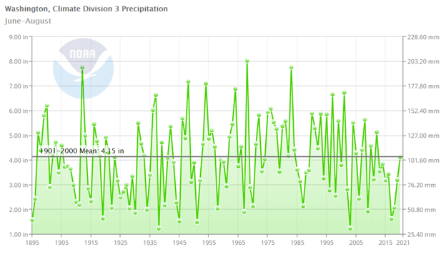
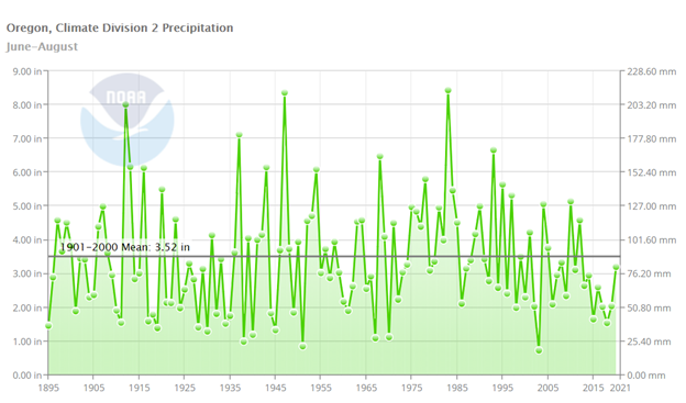
This isn't the case at all. The reason you have this impression is because the local station you like to use was seriously overexposed earlier in the 20th century. Summers in the second half of the 20th century were generally both warmer and sunnier than in the first half, and precip has shown essentially no trend going back to the late 1800s with the possible exception of the last decade or so (though that could easily just be a random blip like we saw in the mid 1920s through the early 30s). There's also fact that September trended much more summerlike over the course of the 20th century. Here are the average summer temps and precip for the Puget Sound and Willamette Valley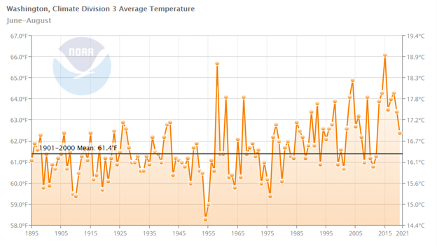

-
July 2021 PNW Weather Discussion
James Jones replied to Meatyorologist's topic in West of the Rockies
1977 might be the ultimate example of this. The first 17 days of the month was perhaps the hottest 17 day stretch on record, then we crashed into fall and never looked back. The last 10 days of the month had 3.59" of rain at SEA, 4.17" at OLM, and 3.26" at PDX. Even a pale imitation of that would be a godsend for our ecosystem. -
July 2021 PNW Weather Discussion
James Jones replied to Meatyorologist's topic in West of the Rockies
The ****? How that post led you to engage in personal insults is beyond me. Apparently even the slightest suggestion that there was colder weather at some point in the past is enough to get you to completely melt down. Get some help. -
July 2021 PNW Weather Discussion
James Jones replied to Meatyorologist's topic in West of the Rockies
At this time in 2015 we were at the start of a troughy period much more "impressive" than anything we're going to see this month. From the 21st through 27th PDX averaged 75.6/58 with .54" of rain, good for -4.7 for the 7 day period including a sub 70 high on the 25th. #ColdJulyMemories -
July 2021 PNW Weather Discussion
James Jones replied to Meatyorologist's topic in West of the Rockies
A November firehose would be nice. The Puget Sound has had some fairly wet ones in recent years but it's been a long time since we've had one down here, and they often portend good things later on. -
July 2021 PNW Weather Discussion
James Jones replied to Meatyorologist's topic in West of the Rockies
I don't get why Phil says it's been humid in D.C. July 3rd only topped out at a 61 degree dewpoint. I mean seriously? It gets worse than that in Finland. Also the 12z EPS shows humidity departures reduced by 40% compared to the 00z run.


