Beltrami Island
-
Posts
368 -
Joined
-
Last visited
Everything posted by Beltrami Island
-
March 2024 Observations and Discussion
Beltrami Island replied to Tom's topic in East of the Rockies
In this case that is the dry slot of this storm, no? Iowa still has the nw to se gradient on average. Minnesota's gradient is particularly contrasting between gulf moisture feeding into storms of upper Mississippi vs the arid plains of ND/MT, etc. -
March 2024 Observations and Discussion
Beltrami Island replied to Tom's topic in East of the Rockies
I am weird,but I find it interesting when a storm system demonstrates climo so closely.
-
3/24-3/27 Midwest/Plains Colorado Low(s)
Beltrami Island replied to Minny_Weather's topic in East of the Rockies
Looking at last nights GFS I was starting to get interested and think maybe the north trend is going to get me into something worth watching. I wake up and see the northern trend smashed with a hard northerly cutoff line to my south reappear. Like living Jan-Feb 2023, watching central and NE Minnesota get crushed while I enjoy the bright clear skies of NW MN. -
ORD and Duluth battling it out 18.5" to 18.7" for the season so far. I can believe ORD has beaten Duluth at some point over an entire cold season. But, you'd have to be a fool to predict this little for Duluth to date.
-
2023 - 2024 Autumn & Winter Discussions
Beltrami Island replied to Tom's topic in East of the Rockies
Had to laugh at this... Accurate for the whole of this winter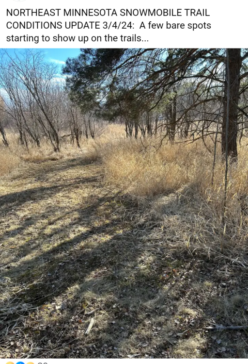
-
March 2024 Observations and Discussion
Beltrami Island replied to Tom's topic in East of the Rockies
Just to tease, Teton pass atm... The entire west is getting hit with the current storm. What's funny out west is, while isolated weather patterns do happen to favor different areas at different times. When good storms hit the west they can cover vast areas from California to Colorado to Montana to Washington at the same time. Snowstorms in the Midwest have maybe a max 200-250 mile wide swath 95% of the time?
-
February 2024 Observations and Discussion
Beltrami Island replied to Tom's topic in East of the Rockies
Quite the unusual weather here the last 24 hours and next 12, just to stay in line with this wacky winter. Woke up to 2" fresh snow yesterday, then a high of 53 in the afternoon melted it all. Even my wife asked, did we move to Denver? Now its dumping snow with temps dropping below zero tonight. NWS says 5-9 inches accumulation today, but back to near 50 by Friday. I have this feeling, the rest of the cold season is going to be a yoyo bouncing between really warm and snowy days. With the rainstorm earlier this month and the Christmas rain it might turn out the cold season will statistically be categorized as wet and snowy imby. But, without looking at temps, the nature of this winter is totally lost. -
February 2024 Observations and Discussion
Beltrami Island replied to Tom's topic in East of the Rockies
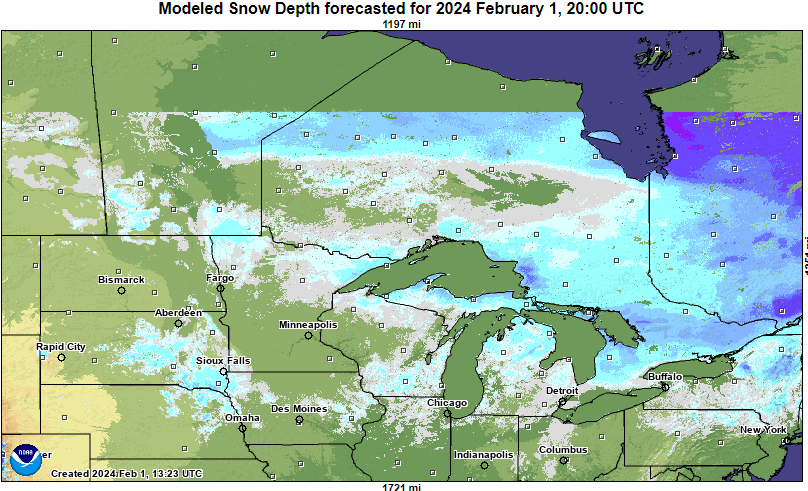
The entire region needs to get some snow on the ground or this spring fire season is going to be awful. I know 2015-2016 the DNR here was ramping up by mid-late winter for all hands on deck in anticipation of high fire danger but a widespread wet 8-10" snowfall third week of March erased the danger. Now here is a fun fantasy model run
-
February 2024 Observations and Discussion
Beltrami Island replied to Tom's topic in East of the Rockies
https://www.weather.gov/wrh/climate?wfo=dlh -
February 2024 Observations and Discussion
Beltrami Island replied to Tom's topic in East of the Rockies
I've noticed going back to early fall, every time a "cold" front has come through the state that the actual wind never seems to have lived up to the speed or duration forecasted by models even 3-4 days out. Those forecasted periods of 36-48 hours of 20-25mph NW winds turned out to be about 12-18 hours of 10-15mph winds before the SE, S, or SW winds returned. I guess just more ways to describe this torch of a winter. As opposed to 2013-14 which felt like day after day of constant 15-20 mph NW winds interrupted by brief lulls due to arctic highs passing overhead. -
February 2024 Observations and Discussion
Beltrami Island replied to Tom's topic in East of the Rockies
I've been to togwotee numerous times so I follow the snotel station there for curiosity sake even if I have no immediate plans to go there. Its been near 0th percentile for snow depth on the date near the entire winter (records going back to 1980-81). Togwotee and west Yellowstone aren't to far from each other as the crow flys, so I would guess they are near the same vs each's avg. Record low snow out there still means 4'+ snow depths at 9-10k feet by this time in the winter. -
February 2024 Observations and Discussion
Beltrami Island replied to Tom's topic in East of the Rockies
For msp cwa 96-97 to 97-98 contrast is similar to this year and last. Enso states compare pretty well I think there as well. Just don't want to follow the trend through 98-99 and 99-00 because that was 3 clunkers in a row for Minnesota and only 00-01 from 97-98 through 02-03 was not below avg snow. -
February 2024 Observations and Discussion
Beltrami Island replied to Tom's topic in East of the Rockies
If you haven't read it yet, read State of Fear by Michael Chrichton... 20 years old now, I should reread it and see how it holds up but it has quite a few examples that look like the red line for us cities up until 2000. -
February 2024 Observations and Discussion
Beltrami Island replied to Tom's topic in East of the Rockies
Up north this is the late Jan/Feb version of March 2012 -
February 2024 Observations and Discussion
Beltrami Island replied to Tom's topic in East of the Rockies
This system keeps coming in with lower and lower SLP and less moisture with each model run it seems. Not very high hopes for this producing anything meaningful other than front end rain and wind and flurries on the backside. -
February 2024 Observations and Discussion
Beltrami Island replied to Tom's topic in East of the Rockies
-58 and -60 according to this... I am skeptical of any measurement of -70 with a handheld thermometer but absolutely believe -70 or lower is possible. NE Minnesota extending up into Ontario has so many little pothole boxed canyon type backwater/swamps (if that makes sense) where under the right conditions cold air just continuously flows down too them like a river connecting a series of lakes, each one colder than the last.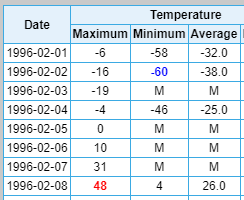
-
February 2024 Observations and Discussion
Beltrami Island replied to Tom's topic in East of the Rockies
A few random facts I've picked up about the about the Tower, MN -60 reading. The snow depth at the site was 44" meaning the reading was taken way lower than the standard 5 feet above the ground, biasing the reading low. The actual reading was -59.5, if normal rounding rules are applied a 5 should be rounded up the next largest integer, well for a -59.5 the next largest integer is -59 not -60. But -60 sounds better and was accepted. The thermometer at the typical cold spot in that area, Embarrass, broke during the night, it can be assumed based on past and subsequent readings then that Embarrass was probably colder. Also in only 6 days Tower warmed to +48f for a 108 degree swing in 6 days. The 44" snow depth is absolutely bonkers as well. Tower is far away from Lake Superior so it has no lake enhancement, it is also is relatively flat having no geographic orthographic lift to aid snowfall. The 44" snow depth is driven purely by synoptic scale weather. One more weird fact, I was a kid at the time and lived closer to the twin cities than northern Minnesota. But, my dad was on a snowmobile trip staying about 30-40 miles from Tower that weekend. There really wasn't much riding to be done, just getting the snowmobiles started was a task. Only carbureted sleds would even start, the first generation fuel injected snowmobiles of that time would not start at all. -
February 2024 Observations and Discussion
Beltrami Island replied to Tom's topic in East of the Rockies
Don't worry MSP you have as much snow as the most of Minnesota. A big swath of Ontario is going to be bare ground as well before anything close to normal winter temps return. To say I have 4" left on the ground might be technically correct, but a lot of bare patches are showing up in wind prone and sun exposed areas. In town its just snowbanks and snow piles looking like late march/april.
-
February 2024 Observations and Discussion
Beltrami Island replied to Tom's topic in East of the Rockies
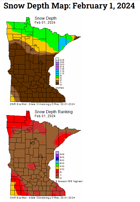
I don't know the official number, 4" in October. 2-3" inches that fell before Christmas and melted. 2-3" in early January. 7-8" of super fluff mid January. I guess that could add up to as much as 18". I know 30-40 miles west had at least 50% more than that. I really don't care what the snowfall number is, I track snow depths/snow water content more than the actual snowfall. The January snow we got was so dry, that 7-8" was probably approaching 30:1 ratios, you could walk through it without even feeling its weight on your feet. Here is what snow depths looked like prior to the meltdown. Even then, areas to my west that had more snow were only barely above the 20th percentile for date. This weeks update is going to have a hole lot more 0-5% areas.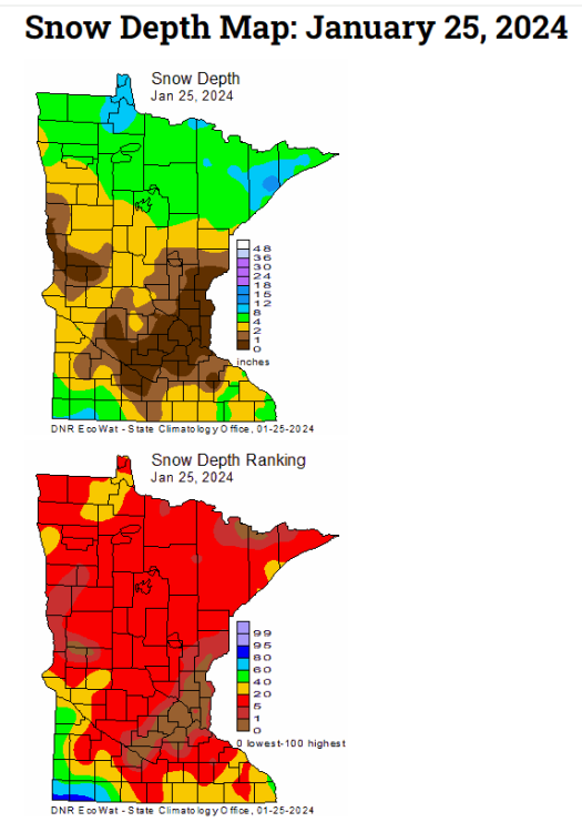
-
February 2024 Observations and Discussion
Beltrami Island replied to Tom's topic in East of the Rockies
In relation to the Northern Plains/Upper Midwest.... If ENSO was a person and ENSO can't lie and ENSO tells you its going to be a crap winter (Very Strong El Nino), you can't act surprised when its a crappy winter. It doesn't make it make things any less crappy having the warning, you just can't act surprised when it happens. 97-98, 15-16, and now The years that sting are years like 2001-02 and 2011-12 where there is no ENSO signal for the very warm winters that ensued. -
February 2024 Observations and Discussion
Beltrami Island replied to Tom's topic in East of the Rockies
Still thinking of heading west this season? I guess there is speculation that we might snap back to a robust la nina next winter. Thinking about la ninas immediately following a mod/strong el nino are 98-99, 2010-11, and 2016-17. I think all 3 of those winters were record/near record snow years out west. Might be worth gambling to wait until next year. -
February 2024 Observations and Discussion
Beltrami Island replied to Tom's topic in East of the Rockies
Is it time to start a season snow total futility record watch for places in the UP? -
You know what el nino you can just go to your room and not come back out until you learn to behave a little better. Nobody around here expects much out of you but you still have this ability to disappoint...
-
2023 - 2024 Autumn & Winter Discussions
Beltrami Island replied to Tom's topic in East of the Rockies
From what I have been able to find elsewhere, this is a non event so to speak. The warming caused the zonal winds of the strat pv to stop and briefly reverse meeting the technical definition of a major SSW. But, the effect wasn't transferred to the troposphere which happens about 1/3 of the time for major SSW? In fact somehow this temp spike is actually related to the strengthening of the strat pv after the non-major SSW around new years. Not saying I can make sense of the correlations/causations just what I read elsewhere. -
January 2024 Observations and Discussion
Beltrami Island replied to Minny_Weather's topic in East of the Rockies
@gimmesnow Colorado has good snow depths at the moment. Utah is good, I think they got some rain at mid elevations though. Pretty much everywhere else is way down... Video from northern Utah.