


Beltrami Island
-
Posts
368 -
Joined
-
Last visited
Everything posted by Beltrami Island
-
November 2021 Observations and Discussion
Beltrami Island replied to Tom's topic in East of the Rockies
I had to look up the exact date because it sticks in my mind. Nov 8 2003 was firearm deer opener for minnesota, much of northern minnesota had -10s for lows that morning. Trees crack as loud as a gun when it gets that cold, warmed to the 40s within 48 hours though. -
November 2021 Observations and Discussion
Beltrami Island replied to Tom's topic in East of the Rockies
Only have to go back to 2014 with widespread -10s for the area. Prior to that I think 1988 or 1989 holds the next coldest memory for cold on Thanksgiving. -
November 2021 Observations and Discussion
Beltrami Island replied to Tom's topic in East of the Rockies
On the flipside I am expecting a different type of bust tomorrow afternoon. A sub 990mb low crawling straight west to east just north of the US/CAN border and my NWS forecast has a high of 38. With this scenario I will be happy if it stays below 45. Similar situations in the past have brought temps to near 50 on the MN/ON border in the middle of winter with a large snowpack. This is one of those scenarios where I wonder if I am missing something in the models that a degreed meteorologist can see? -
Overall agree this was a dud. Bark worse than bite. Biggest issue was yesterday it snowed pretty much all day without no accumulation, snow in the air but rain practically. Once it cooled off around sunset last night and it finally started to accumulate, the snow had much less qpf than models previously showed. I don't know if its everywhere or just particular to my area, but moisture on the NW side of storms is way overdone consistently on all models, from the latest high res Euro to the lowest res NAM. This time was no exception.
-
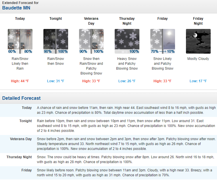
Snowfall rate is finally starting to pick up. Been snowing lightly most of the day but not fast enough to overcome the warm ground and accumulate. NWS says 3-5" daytime accumulation, its going to have to start dumping at 1" accumulation per hour to be close to 3" accumulation. At 33f that is very heavy snowfall rate.
-
My point forecast at the moment: Detailed Forecast Veterans Day Snow. Steady temperature around 33. Breezy, with a north northeast wind 15 to 23 mph, with gusts as high as 33 mph. Chance of precipitation is 100%. Total daytime snow accumulation of 3 to 7 inches possible. Tonight Snow. Patchy blowing snow before 11pm, then patchy blowing snow after 2am. Low around 26. Blustery, with a north northeast wind 21 to 23 mph, with gusts as high as 37 mph. Chance of precipitation is 100%. New snow accumulation of 3 to 5 inches possible. Friday Snow likely, mainly before 3pm. Patchy blowing snow before 7am. Cloudy, with a high near 33. Breezy, with a north wind 18 to 22 mph, with gusts as high as 36 mph. Chance of precipitation is 60%. New snow accumulation of less than one inch possible.
-
Not my location, it's the area N/NE of Lake of the Woods Canadian side. Where the heaviest snowfall for this storm is likely to be.
-
Alerts for: Red Lake - Ear Falls Up to 50cm = 20 inches of wet snow. In comparison, this same area had nearly bare ground all of last winter.
-
Quite the mess this morning. Can't even really tell how much it snowed vs rained vs ground melted snow. Side roads are a sloppy slushy mess. All the maps have me in the bullseye for this one on the US side. I think in 3-4 hours is when the hammer of snow is supposed to get going, we'll see.
-
Change to snow is late and counting for me.... Main rain snow line still well into Canada on radar...
-
I am really surprised with the conservative trend wrt public safety over the last couple years from the FGF office that I don't at least have a Winter Strom Watch issued with this point forecast.
-
I still have stinging memories of Nov 2017 probably affecting my feelings about this snow potential. Had lots of snow and cold temps the first 3 weeks of the month building a solid snowpack 8-12" deep. It felt like mid winter, then Thanksgiving weekend brought rain and 40s melting it all to the grass.
-
I am still hopeful, but skeptical for significant snowfall amounts imby. Temps, air and ground really are not ideal for accumulations and in my experience the models are always to quick to transition from rain to snow. The hard cutoff to my south in the snow forecast does actually help my optimism. My biggest snow events have these strong cutoffs right around Red Lake.
-
I just don't buy how much wrap around QPF models show on the NW side of the surface or upper lows. Models seem to always show significant amounts that never come to fruition be it snow in the winter or rain in warm season. I am expecting some flakes and light-moderate accumulation at most, lots of wind, and the arrival of some seasonable cold air.
-
November 2021 Observations and Discussion
Beltrami Island replied to Tom's topic in East of the Rockies
That's me on the US/Canada border at 20.0". I don't know what to say, this is the craziest model run I have ever seen for my location. The max is 38" in NW Ontario. Do I get the snow blower ready and jinx it, or not? -
October 2021 Observations and Discussion
Beltrami Island replied to Tom's topic in East of the Rockies
Those Black Hills...seems like they get one of these storms every spring and fall. The ultimate in recent times seems to be 1998. https://www.weather.gov/unr/1998-02-25_03-01 -
Autumn & Winter 2021-22 Observations and Discussion
Beltrami Island replied to Tom's topic in East of the Rockies
This is awesome to see and interesting. The Duluth NWS/airport sites sits right at the top of "The Hill" in a prime spot for E/NE upslope flow right off the lake for Superior cutters systems. Makes me want to do similar for other Minnesota cities like Brainerd, Bemidji, and Grand Rapids where snowfall is 100% synoptic and also parse out numbers for seasonal vs Dec-Mar where spring/fall snowstorms distort the seasonal totals (I am looking at you Halloween 1991). -
Autumn & Winter 2021-22 Observations and Discussion
Beltrami Island replied to Tom's topic in East of the Rockies
I do like the idea of your attempted analysis correlating october temps to the following winter snowfall. I have had a feeling there is a correlation for a while. It won't work for KC, probably not Chicago either. Maybe MSP, but I would like to see the results for an area like duluth/superior outside of lake effected/enhancement snow areas. I don't have time to gather the data though. -
Autumn & Winter 2021-22 Observations and Discussion
Beltrami Island replied to Tom's topic in East of the Rockies
I don't think KC has consistent or high enough average snowfall to do this kind of analysis. You need to have a higher average and larger deviations to draw any conclusions from the data. For a generic local in the UP for instance that averages 200" per year, years with 150" or 250" are significant deviations from the average but probably easily within statistically expected values. Where as for KC with an average of 30"(?), a 12" snowstorm or lack there of represent nearly half the annual average. A statistician can probably state what I am thinking more eloquently. -
Autumn & Winter 2021-22 Observations and Discussion
Beltrami Island replied to Tom's topic in East of the Rockies
@gimmesnowI agree with you. My ideal October through 2nd week of November weather is dry and above normal temps, then a gradual return to averages by Thanksgiving. After Thanksgiving nature can drop the hammer of unending snow and cold (with emphasis on the snow) until April. 2018 and 2020 Octobers were cold and miserable here. 2019 was endless rain. The next few weeks look like my kind of October weather. -
September 2021 Observations and Discussion
Beltrami Island replied to Tom's topic in East of the Rockies
If you have the time, check out the Lost 40 south of northome. That area has the best area for fall colors in the area in addition to massive trees. -
September 2021 Observations and Discussion
Beltrami Island replied to Tom's topic in East of the Rockies
Frost advisory was just to my east. To much wind overnight for frost this morning here, only got down to mid 40s. Fall color is developing day by day. Very drab fall colors this year due to the dry summer. -
September 2021 Observations and Discussion
Beltrami Island replied to Tom's topic in East of the Rockies
Last night was the rainiest night I can remember in forever it seems. 5-6 hours of constant rain shifting between steady, moderate, and heavy rain, nothing severe but decent amount of thunder. You really couldn't have drawn a better a better outcome for the D4 drought areas of northern Minnesota.
-
September 2021 Observations and Discussion
Beltrami Island replied to Tom's topic in East of the Rockies
It's definitely started and things maybe a little early through the season due to the drought. Some trees have been dropping leaves early as well, presumably from drought. Still majority full green so far though. -
August 2021 Observations and Discussion
Beltrami Island replied to Tom's topic in East of the Rockies
A 24-36 hour non severe weather soaking rain system would feel like heaven at this point. It can be argued that northern minnesota is an interconnected system of lakes, rivers, swamps, wetlands, etc. with interspersed areas of higher ground. Well, the lakes and rivers are at low levels and the swamps and wetlands are nearly if not completely dried up at this point. Fire danger is about as high as it can be at this point. It seems like there is a new fire somewhere in the region everyday. So far a large fire has been avoided until now, but it could get catastrophically worse without significant rain before leaves fall and vegetation dies off before cold season. Historically, the biggest and most destructive fires in Minnesota are in Sep-Oct and even Nov.


